Long Range Thread 8.0
+30
Grselig
devsman
chief7
oldtimer
Noreaster
Quietace
mako460
jimv45
rb924119
sroc4
HectorO
snow247
essexcountypete
chinkaps
billg315
Snow88
dkodgis
docstox12
WOLVES1
nutleyblizzard
CPcantmeasuresnow
algae888
skinsfan1177
Dunnzoo
weatherwatchermom
Math23x7
jmanley32
amugs
Dtone
Frank_Wx
34 posters
Page 12 of 40
Page 12 of 40 •  1 ... 7 ... 11, 12, 13 ... 26 ... 40
 Re: Long Range Thread 8.0
dkodgis wrote:Doc, we will all be monitoring the ridge and the El Nino position ... because ... as I paraphrase Mugs... we are snow weenies! As for the cigars, it is on the deck for me and a heater out there keeps me alive until early Dec. Then I do the shed (man cave). However, even my wife has tried chick sticks...she is just not into them. Coming back to El Nino, may I ask if Joe Bastardi is still saying the cold winter trend is likely in 2015-2016?
JB is def still on the cold train. He has pointed out that the JMA (his favorite LR model), the Euro and the UKMET are all showing support. The CFS cont to be the outlier, but he is not worried at this time. Again still alot to monitor and alot can change. This is a quote from Tomas Downs, a Met on the Weatherbell team that collaborates along with JB and a couple others to produce the winter forecast. This is what Mugs has been touting.
"For the winter forecast, the most important thing may be how the Nino1+2 region responds. If it continues to lag the Nino3.4 anomaly, a pattern like 1997-98 would be unlikely. This is the scenario that WeatherBell has anticipated for quite some time now.
There still is a chance for the Nino1+2 region to warm significantly. For that to happen there would have to be a decrease in the strength of the trade winds across the far eastern Pacific. This would shut down upwelling off the coast and the SSTs can respond very quickly (a matter of one or two weeks). To have long-lasting implications for the winter, however, those weak trade winds would have to remain for weeks on end, as any strengthening of the trades would promote rapid cooling.
So to put it bluntly, while Nino1+2 has the chance to overtake Nino3.4 as the warmest region, the odds are currently against it."
sroc4- Admin

- Posts : 8331
Join date : 2013-01-07
 Re: Long Range Thread 8.0
Latest weekly ENSO readings shows that area 1.2 has warmed up since last week. Not a good thing if you want cold and snow. However models show that cooling will take place in the coming weeks so this should be only a temporary spike.
nutleyblizzard- Senior Enthusiast

- Posts : 1952
Join date : 2014-01-30
 Re: Long Range Thread 8.0
nutleyblizzard wrote:Latest weekly ENSO readings shows that area 1.2 has warmed up since last week. Not a good thing if you want cold and snow. However models show that cooling will take place in the coming weeks so this should be only a temporary spike.
Yes they did and I concur with this statement. We should see a cooling in the next few weeks and region 3.4 and 4 is warming - so the warm el nino bathtub or hot tub is basin wide at this stage. WXbell boys are expecting this to occur as well. If a month from now we are seeing 1.2 still warm at this stage then we start to head to the SA coast and put our underwater turbines in the PAc and turn them on full blast towards the Indian OCEAN!!

_________________
Mugs
AKA:King: Snow Weenie
Self Proclaimed
WINTER 2014-15 : 55.12" +.02 for 6 coatings (avg. 35")
WINTER 2015-16 Total - 29.8" (Avg 35")
WINTER 2016-17 : 39.5" so far

amugs- Advanced Forecaster - Mod

- Posts : 15093
Reputation : 213
Join date : 2013-01-07
Age : 54
Location : Hillsdale,NJ
 Re: Long Range Thread 8.0

KEEP GROWING MY CHIA PET!!

_________________
Mugs
AKA:King: Snow Weenie
Self Proclaimed
WINTER 2014-15 : 55.12" +.02 for 6 coatings (avg. 35")
WINTER 2015-16 Total - 29.8" (Avg 35")
WINTER 2016-17 : 39.5" so far

amugs- Advanced Forecaster - Mod

- Posts : 15093
Reputation : 213
Join date : 2013-01-07
Age : 54
Location : Hillsdale,NJ
 Re: Long Range Thread 8.0
dkodgis wrote:I wish there were a cigar club where all professional meteorologists could go and hang out and be professionals and not "wait and see" folks. TV weather has always reminded me, at least for the last 20 years, of the Harlem Globetrotters. You know they have super skills, you know they can play, but their primary purpose is to entertain. Everyone keeps it five-minute format and "weather" suffers. This is what drove me here to this board (plus the very funny posts and very nice people with good listening skills, good conflict mgt skills, and superior social skills). Is it going to rain? Is it going to snow? What is the temp today? <--are all good questions but why and how are the things I want to know and I get them here. Good visuals, good synthesis of facts to put complex ideas and topics within reach of readers, citations, and good banter=a fun place with good info. Thanks everyone for making the board what it is.
Thanks for this post! So many people do a great job of giving their input here. Lots of expertise analysis.
nutleyblizzard wrote:Latest weekly ENSO readings shows that area 1.2 has warmed up since last week. Not a good thing if you want cold and snow. However models show that cooling will take place in the coming weeks so this should be only a temporary spike.
That actually is a little disheartening to hear. Some models are showing the greatest forcing taking place over the central ENSO regions so maybe we'll see a reverse next week.
_________________
_______________________________________________________________________________________________________
CLICK HERE to view NJ Strong Snowstorm Classifications
 Re: Long Range Thread 8.0
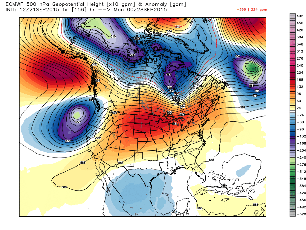
You can tell we've entered the fall season when H5 maps start looking like this. It looks like the pattern has no idea what it wants to do. That's basically going to be the case through October. What's key for winter is how other variables come together (ENSO, Stratosphere, Snow Cover, etc..)

_________________
_______________________________________________________________________________________________________
CLICK HERE to view NJ Strong Snowstorm Classifications
 Re: Long Range Thread 8.0
Interesting article but by a Jersey Shore paper.
http://patch.com/new-jersey/longbranch/strong-noreasters-expected-hit-new-jersey-fall-winter-arrive
http://patch.com/new-jersey/longbranch/strong-noreasters-expected-hit-new-jersey-fall-winter-arrive
_________________
Mugs
AKA:King: Snow Weenie
Self Proclaimed
WINTER 2014-15 : 55.12" +.02 for 6 coatings (avg. 35")
WINTER 2015-16 Total - 29.8" (Avg 35")
WINTER 2016-17 : 39.5" so far

amugs- Advanced Forecaster - Mod

- Posts : 15093
Reputation : 213
Join date : 2013-01-07
Age : 54
Location : Hillsdale,NJ
 Re: Long Range Thread 8.0
amugs wrote:Interesting article but by a Jersey Shore paper.
http://patch.com/new-jersey/longbranch/strong-noreasters-expected-hit-new-jersey-fall-winter-arrive
I saw that earlier, can't believe they are making predictions this early.....
_________________
Janet
Snowfall winter of 2023-2024 17.5"
Snowfall winter of 2022-2023 6.0"
Snowfall winter of 2021-2022 17.6" 1" sleet 2/25/22
Snowfall winter of 2020-2021 51.1"
Snowfall winter of 2019-2020 8.5"
Snowfall winter of 2018-2019 25.1"
Snowfall winter of 2017-2018 51.9"
Snowfall winter of 2016-2017 45.6"
Snowfall winter of 2015-2016 29.5"
Snowfall winter of 2014-2015 50.55"
Snowfall winter of 2013-2014 66.5"
Dunnzoo- Senior Enthusiast - Mod

- Posts : 4891
Reputation : 68
Join date : 2013-01-11
Age : 62
Location : Westwood, NJ
 Re: Long Range Thread 8.0
Not even taking any of this seriously until Frank works up his winter forecast in 5 or 6 weeks.

docstox12- Wx Statistician Guru

- Posts : 8504
Reputation : 222
Join date : 2013-01-07
Age : 73
Location : Monroe NY
 Re: Long Range Thread 8.0
amugs wrote:Interesting article but by a Jersey Shore paper.
http://patch.com/new-jersey/longbranch/strong-noreasters-expected-hit-new-jersey-fall-winter-arrive
Whoever wrote this is r******d with grammer (and I am pretty sure Mt. Holly didnt say “It is indicating the chance of higher than normal temperatures and wetter than normal temperatures,” said Mitchell Gaines, an NWS meteorologist in Mount Holly. “We are going to have a strong El Nino which does indicate a stronger storm track.” Ummmmm.....wetter than normal temperatures and a stronger storm track, lol is all I can say to that!? And many of the things in it worded do not make sense at all. Is this a satire site because its written so poorly anyone who takes it seriously should be committed lol jk mugs.

jmanley32- Senior Enthusiast

- Posts : 20516
Reputation : 108
Join date : 2013-12-12
Age : 42
Location : Yonkers, NY
 Re: Long Range Thread 8.0
That article was not very good. I couldn't even take it seriously.
_________________
_______________________________________________________________________________________________________
CLICK HERE to view NJ Strong Snowstorm Classifications
 Re: Long Range Thread 8.0
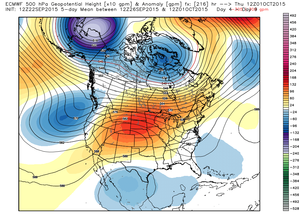
By the end of this month into early October, you'll notice below normal heights begin to encompass much of central and northern Canada. This includes Alaska into the Arctic Circle...a true indicator colder weather is on the way. Most importantly, the aforementioned areas should be building up a nice snow pack in this time. We'll revisit the Snow Cover maps in the 2nd week of October and see how they look.

_________________
_______________________________________________________________________________________________________
CLICK HERE to view NJ Strong Snowstorm Classifications
 Re: Long Range Thread 8.0
This from steve d this morning about the nao and atlantic sst.
"While Ida is no threat to any land mass, Ida does have the potential to help to drive the NAO into a deep negative phase for the first 15 days of October before rebounding towards neutral once again. This is one of the few tropical systems in the Atlantic able to transport latent heat energy into the Polar regions of the Atlantic and may be one of the last as well. This is an important observation going forward.
The fact is that this Hurricane Season has be all but dead for the coastal waters of the East coast, which IS a good thing. However, while we dodge storms from tropical and extratropical nature now, I do not think we get away with this for long.
The SSTA in the Atlantic point to a perfect support for a sustained negative NAO pattern, especially a west based negative NAO in the winter months. Why? Because of the thermal gradient developing at the low levels of the atmosphere to the mid levels of the atmosphere. Basically, if you wanted to create an environment at the lower levels for constant low pressure system development, well you have a perfect environment for that in the western Atlantic."

algae888- Advanced Forecaster

- Posts : 5311
Reputation : 46
Join date : 2013-02-05
Age : 61
Location : mt. vernon, new york
 Re: Long Range Thread 8.0
If the long range GFS is correct 10+ days out we should see a significant cool down with the 540 line making it into our area and much of New England getting below freezing at night.

algae888- Advanced Forecaster

- Posts : 5311
Reputation : 46
Join date : 2013-02-05
Age : 61
Location : mt. vernon, new york
 Re: Long Range Thread 8.0
algae888 wrote:This from steve d this morning about the nao and atlantic sst.
"While Ida is no threat to any land mass, Ida does have the potential to help to drive the NAO into a deep negative phase for the first 15 days of October before rebounding towards neutral once again. This is one of the few tropical systems in the Atlantic able to transport latent heat energy into the Polar regions of the Atlantic and may be one of the last as well. This is an important observation going forward.
The fact is that this Hurricane Season has be all but dead for the coastal waters of the East coast, which IS a good thing. However, while we dodge storms from tropical and extratropical nature now, I do not think we get away with this for long.
The SSTA in the Atlantic point to a perfect support for a sustained negative NAO pattern, especially a west based negative NAO in the winter months. Why? Because of the thermal gradient developing at the low levels of the atmosphere to the mid levels of the atmosphere. Basically, if you wanted to create an environment at the lower levels for constant low pressure system development, well you have a perfect environment for that in the western Atlantic."
So basically no hurricanes but big chances of big noreasters giggity!

jmanley32- Senior Enthusiast

- Posts : 20516
Reputation : 108
Join date : 2013-12-12
Age : 42
Location : Yonkers, NY
 Re: Long Range Thread 8.0
algae888 wrote:If the long range GFS is correct 10+ days out we should see a significant cool down with the 540 line making it into our area and much of New England getting below freezing at night.
Yeah saw that brrrr, is it a good thing through to have cold too early? I remember our first big storm threat last year was right after Halloween, wonder how long it will be before we see our first bomb on the LR models.

jmanley32- Senior Enthusiast

- Posts : 20516
Reputation : 108
Join date : 2013-12-12
Age : 42
Location : Yonkers, NY
 Re: Long Range Thread 8.0
jman not a bomb but snow in southern Canada on the lr gfs... love to see the blue on the models.jmanley32 wrote:algae888 wrote:If the long range GFS is correct 10+ days out we should see a significant cool down with the 540 line making it into our area and much of New England getting below freezing at night.
Yeah saw that brrrr, is it a good thing through to have cold too early? I remember our first big storm threat last year was right after Halloween, wonder how long it will be before we see our first bomb on the LR models.


algae888- Advanced Forecaster

- Posts : 5311
Reputation : 46
Join date : 2013-02-05
Age : 61
Location : mt. vernon, new york
 Re: Long Range Thread 8.0
Just a question, BUT DID ANYBODY SEE THE 12z EURO OP FOR DAY 10???!!! Makes me all warm and fuzzy inside just thinking about it 


Btw, Sroc, I didn't forget about your request, I actually just got my desktop set up on my desk that was delivered yesterday haha It shall be followed up with in the upcoming days. I HATE working on a laptop lol
Btw, Sroc, I didn't forget about your request, I actually just got my desktop set up on my desk that was delivered yesterday haha It shall be followed up with in the upcoming days. I HATE working on a laptop lol
rb924119- Meteorologist

- Posts : 6890
Reputation : 194
Join date : 2013-02-06
Age : 32
Location : Greentown, Pa
 Re: Long Range Thread 8.0
rb924119 wrote:Just a question, BUT DID ANYBODY SEE THE 12z EURO OP FOR DAY 10???!!! Makes me all warm and fuzzy inside just thinking about it


Btw, Sroc, I didn't forget about your request, I actually just got my desktop set up on my desk that was delivered yesterday haha It shall be followed up with in the upcoming days. I HATE working on a laptop lol
Thanks Bud. I appreciate it!
_________________
"In weather and in life, there's no winning and losing; there's only winning and learning."
WINTER 2012/2013 TOTALS 43.65"WINTER 2017/2018 TOTALS 62.85" WINTER 2022/2023 TOTALS 4.9"
WINTER 2013/2014 TOTALS 64.85"WINTER 2018/2019 TOTALS 14.25" WINTER 2023/2024 TOTALS 13.1"
WINTER 2014/2015 TOTALS 71.20"WINTER 2019/2020 TOTALS 6.35"
WINTER 2015/2016 TOTALS 35.00"WINTER 2020/2021 TOTALS 37.75"
WINTER 2016/2017 TOTALS 42.25"WINTER 2021/2022 TOTALS 31.65"

sroc4- Admin

- Posts : 8331
Reputation : 301
Join date : 2013-01-07
Location : Wading River, LI
 Re: Long Range Thread 8.0
rb924119 wrote:Just a question, BUT DID ANYBODY SEE THE 12z EURO OP FOR DAY 10???!!! Makes me all warm and fuzzy inside just thinking about it


Btw, Sroc, I didn't forget about your request, I actually just got my desktop set up on my desk that was delivered yesterday haha It shall be followed up with in the upcoming days. I HATE working on a laptop lol
What did it show

skinsfan1177- Senior Enthusiast

- Posts : 4485
Reputation : 35
Join date : 2013-01-07
Age : 46
Location : Point Pleasant Boro
 Re: Long Range Thread 8.0
Skins not sure what this is but its a insane amount of precip! It comes in from the west and looks like a insanely intense frontal LP, but it kinda rotates, rb can you explain what this excited you? Imagine if it was winter omg. Would the future frames develop a coastal off of this?


jmanley32- Senior Enthusiast

- Posts : 20516
Reputation : 108
Join date : 2013-12-12
Age : 42
Location : Yonkers, NY

jmanley32- Senior Enthusiast

- Posts : 20516
Reputation : 108
Join date : 2013-12-12
Age : 42
Location : Yonkers, NY

jmanley32- Senior Enthusiast

- Posts : 20516
Reputation : 108
Join date : 2013-12-12
Age : 42
Location : Yonkers, NY
 Re: Long Range Thread 8.0
VT would be inundated verbatim, this all in about 24 hrs yikes! Also carrying some pretty strong winds with it verbatim gusts 40kts in the area, but yes I have learned winds rarely happen the way they are shown on runs let alone 10 days out.


jmanley32- Senior Enthusiast

- Posts : 20516
Reputation : 108
Join date : 2013-12-12
Age : 42
Location : Yonkers, NY
 Re: Long Range Thread 8.0

Crazy -EPO, AO that is headed from near neutral back into negative territory, negative to neutral NAO and a nice PNA ridge. It may be early in the season, but that is a pretty nice look at H5 in my opinion. The top of the PNA ridge is folding over, which is why the upper-level low over the Northeast gets closed off/cut off, but those are details that I couldn't care less about at this point. The overall pattern looks really, really promising, though, especially if we can keep it into Winter. So far, it looks to me like the PV is already having a tendency to be split favorably for us, as it is continuing to be advertised that it will drift southward near/over Hudson Bay in the medium and long ranges. As an aside, I'm REALLY liking the fact that we are getting all of these coastals to develop so early in the season. I'm a very firm believer in that wherever the storm track is during the Autumn that is where it will likely be for much of the upcoming Winter season. Again, just my own opinion.
rb924119- Meteorologist

- Posts : 6890
Reputation : 194
Join date : 2013-02-06
Age : 32
Location : Greentown, Pa
 Re: Long Range Thread 8.0
A second comment about the map I just posted: Take note of the trailing negative height anomalies that extend back through Texas. That's indicative of trailing energy that is rounding the ridge and still entering the base of the trough. In a "normal" year, that's nice to see.....in an El Nino year, that's REALLY NICE to see, especially if this was DJF.
rb924119- Meteorologist

- Posts : 6890
Reputation : 194
Join date : 2013-02-06
Age : 32
Location : Greentown, Pa
 Re: Long Range Thread 8.0
I know its in fantasy land but look at the storm track. that would be rain with temps in the 40's for early October. surface fits 500mb setup that rb posted above on euro...


algae888- Advanced Forecaster

- Posts : 5311
Reputation : 46
Join date : 2013-02-05
Age : 61
Location : mt. vernon, new york
Page 12 of 40 •  1 ... 7 ... 11, 12, 13 ... 26 ... 40
Page 12 of 40
Permissions in this forum:
You cannot reply to topics in this forum|
|
|

 Home
Home
