
 Search
Update on Where our Pattern has Evolved to and Why
+3
Bkdude
Mathgod55
sroc4
7 posters

Update on Where our Pattern has Evolved to and Why
![]() by sroc4 Tue Jan 12, 2016 11:55 am
by sroc4 Tue Jan 12, 2016 11:55 am
Hey guys and gals. I have decided to take a look at what's happening now and why our pattern is the way it is. As a reminder here was my take on the pattern up through New years: https://www.njstrongweatherforum.com/t610-mjo-has-played-a-major-role-to-this-point
Now the focus is no longer on MJO, or I should say much less of a degree, and more so on the true ENSO influences
First is the Sat image of the E Pac from Jan 5th. Notice the strong convection near the dateline(left side of image, and the lack of to the East.

 " />
" />
Next is an image from Yesterday. Notice the conv around the dateline is spread out and somewhat diminished, but not gone, and much of it has shifted south of the equator. Additionally there is a flare up of convection now in E Trop Pac zones which is clearly enhancing the STJ.
 " />
" />
Next is the image of the daily, and monthly SOI values dating back to Dec 14th:
You can see the numbers outlined in blue through Dec 23rd avg between approx. (-10)-(+10) This was clearly a sign of El Nino weakening as values sustained -10 or lower are typical of El Nino conditions. However over the last 2-3weeks the daily SOI has crashed to strong neg values and the result has been the redevelopment of sustained westerly wind bursts.
 " />
" />
The result of this is to pile up the warm trop waters in the east as seen by the spike in SSTA on this next image. (Note in the next image a typo is present. Should read....when the SOI was sustained "above" -8 to -10...)
 " />
" />
 " />
" />
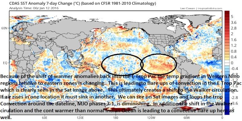
This next image clearly shows the last 7day SSTA change in the Trop Pac.
 " />
" />
 " />
" />
 " />
" />
 " />
" />
Here are the links to the loops of the W Pac. It shows my points very clearly:
http://www.goes.noaa.gov/dml/jma/fd/wvblue.html
http://www.goes.noaa.gov/dml/jma/fd/wv.html
To summarize:
For me a combination of factors are occurring here. The approx 2-3 week sustained strongly negative SOI values has led to a sustained and moderately strong westerly wind burst in the Trop Pac. This has led to the warmer waters of the Central Trop Pac to pile up in the eastern Nino zones as clearly seen by the spike in SST anomalies in that region. The result of this is to affect the temp gradients within the Trop Pac as a whole. This affects the Walker circulation. By allowing convection to occur in the Eastern Trop Pac (directly resulting from the temp spike in this region, and shift in the temp gradient as a whole) we are leading to some sinking air over the dateline region effectively knocking,(but not completely) down and spreading out what was a very robust convective field a bit earlier in the month in this region. By creating descending air in the region around the dateline we effectively remove the cap if you will over the Indian Ocean. Because it is still well above normal SSTA a burst of convection is now occurring there enhancing the polar westerly's again. This time however, I do not believe it propagates into the Warm phases(4-6) of the MJO although this is not a guarantee. It still may however make it into phases 2-3. We are going to need to see the SOI value come up soon and stay there for awhile to allow the rebound of the warmer waters in Nino 1.2 to cool significantly again re-establishing a better temp gradient overall in the trop Pac.
It appears to me that right now there is still some influence into the Aleutian trough by the convection near the dateline and will cont to do so, however, the influence on the polar jet by the convection over the IO seems to be what is causing the Aleutian trough to shift east, closer to the W coast of NA, than it otherwise normally would be if this where not present. I believe this the case because looking at the sat loops this convection is enhancing a trough west of the Aleutian trough. So we get pieces of that trough kick our Aleutian trough east towards the NA west coast. Pieces of this then break off, dive into the SW Rockies, and undercut our PNA ridge. Because this 500mb energy has been for the most part potent(thanks El Nino), and because it is knocking down our western ridge as is comes into the SW it has been allowed to pump the ridge out ahead of it effectively leading to energy that wants to cut before transferring of the coast. This is simply how I see it. I am by no means an expert and some or all of my points may be right or wrong for the right or wrong reasons.
The stratospheric warming occurring as we speak and what is forecast to do by the end of the Month should lead to more sustained blocking in the northern latitudes, and this should re-shift many of the atmospheric anomalies I outlined above once again, hopefully for the better for snow lovers. If we can shut down the IO and cool Nino 1.2 again we should be able to lock in the Aluetian trough in a much more favorable position. But that conversation is for another time. I will leave you with this image of 70mb from this morning showing that it is in fact split as you read.
 " />
" />
I wouldn't cancel winter if I were you in the East. I still predict 50"+ IMBY (LI NY) by the end of the season(first snowfall to last snow fall). I will also again point out that to this point in the season relative to last year I am a mere 2" behind where I was this time last year for my snowfall totals and I ended up with over 70" total. I know its a much diff set up and different drivers are going to need to work for the better going forward for this to happen, but it aint over by a long shot. Yes some feature can be viewed through analogue packages but this entire season thus far is by and large unprecedented in many ways.
Now the focus is no longer on MJO, or I should say much less of a degree, and more so on the true ENSO influences
First is the Sat image of the E Pac from Jan 5th. Notice the strong convection near the dateline(left side of image, and the lack of to the East.
" />Next is an image from Yesterday. Notice the conv around the dateline is spread out and somewhat diminished, but not gone, and much of it has shifted south of the equator. Additionally there is a flare up of convection now in E Trop Pac zones which is clearly enhancing the STJ.
" />Next is the image of the daily, and monthly SOI values dating back to Dec 14th:
You can see the numbers outlined in blue through Dec 23rd avg between approx. (-10)-(+10) This was clearly a sign of El Nino weakening as values sustained -10 or lower are typical of El Nino conditions. However over the last 2-3weeks the daily SOI has crashed to strong neg values and the result has been the redevelopment of sustained westerly wind bursts.
" />The result of this is to pile up the warm trop waters in the east as seen by the spike in SSTA on this next image. (Note in the next image a typo is present. Should read....when the SOI was sustained "above" -8 to -10...)
" />" />This next image clearly shows the last 7day SSTA change in the Trop Pac.
" />" />" />" />Here are the links to the loops of the W Pac. It shows my points very clearly:
http://www.goes.noaa.gov/dml/jma/fd/wvblue.html
http://www.goes.noaa.gov/dml/jma/fd/wv.html
To summarize:
For me a combination of factors are occurring here. The approx 2-3 week sustained strongly negative SOI values has led to a sustained and moderately strong westerly wind burst in the Trop Pac. This has led to the warmer waters of the Central Trop Pac to pile up in the eastern Nino zones as clearly seen by the spike in SST anomalies in that region. The result of this is to affect the temp gradients within the Trop Pac as a whole. This affects the Walker circulation. By allowing convection to occur in the Eastern Trop Pac (directly resulting from the temp spike in this region, and shift in the temp gradient as a whole) we are leading to some sinking air over the dateline region effectively knocking,(but not completely) down and spreading out what was a very robust convective field a bit earlier in the month in this region. By creating descending air in the region around the dateline we effectively remove the cap if you will over the Indian Ocean. Because it is still well above normal SSTA a burst of convection is now occurring there enhancing the polar westerly's again. This time however, I do not believe it propagates into the Warm phases(4-6) of the MJO although this is not a guarantee. It still may however make it into phases 2-3. We are going to need to see the SOI value come up soon and stay there for awhile to allow the rebound of the warmer waters in Nino 1.2 to cool significantly again re-establishing a better temp gradient overall in the trop Pac.
It appears to me that right now there is still some influence into the Aleutian trough by the convection near the dateline and will cont to do so, however, the influence on the polar jet by the convection over the IO seems to be what is causing the Aleutian trough to shift east, closer to the W coast of NA, than it otherwise normally would be if this where not present. I believe this the case because looking at the sat loops this convection is enhancing a trough west of the Aleutian trough. So we get pieces of that trough kick our Aleutian trough east towards the NA west coast. Pieces of this then break off, dive into the SW Rockies, and undercut our PNA ridge. Because this 500mb energy has been for the most part potent(thanks El Nino), and because it is knocking down our western ridge as is comes into the SW it has been allowed to pump the ridge out ahead of it effectively leading to energy that wants to cut before transferring of the coast. This is simply how I see it. I am by no means an expert and some or all of my points may be right or wrong for the right or wrong reasons.
The stratospheric warming occurring as we speak and what is forecast to do by the end of the Month should lead to more sustained blocking in the northern latitudes, and this should re-shift many of the atmospheric anomalies I outlined above once again, hopefully for the better for snow lovers. If we can shut down the IO and cool Nino 1.2 again we should be able to lock in the Aluetian trough in a much more favorable position. But that conversation is for another time. I will leave you with this image of 70mb from this morning showing that it is in fact split as you read.
" />I wouldn't cancel winter if I were you in the East. I still predict 50"+ IMBY (LI NY) by the end of the season(first snowfall to last snow fall). I will also again point out that to this point in the season relative to last year I am a mere 2" behind where I was this time last year for my snowfall totals and I ended up with over 70" total. I know its a much diff set up and different drivers are going to need to work for the better going forward for this to happen, but it aint over by a long shot. Yes some feature can be viewed through analogue packages but this entire season thus far is by and large unprecedented in many ways.
Last edited by sroc4 on Tue Jan 12, 2016 9:27 pm; edited 1 time in total
_________________
"In weather and in life, there's no winning and losing; there's only winning and learning."
WINTER 2012/2013 TOTALS 43.65"WINTER 2017/2018 TOTALS 62.85" WINTER 2022/2023 TOTALS 4.9"
WINTER 2013/2014 TOTALS 64.85"WINTER 2018/2019 TOTALS 14.25" WINTER 2023/2024 TOTALS 13.1"
WINTER 2014/2015 TOTALS 71.20"WINTER 2019/2020 TOTALS 6.35"
WINTER 2015/2016 TOTALS 35.00"WINTER 2020/2021 TOTALS 37.75"
WINTER 2016/2017 TOTALS 42.25"WINTER 2021/2022 TOTALS 31.65"

sroc4- Admin

- Posts : 8331
Reputation : 301
Join date : 2013-01-07
Location : Wading River, LI
Re: Update on Where our Pattern has Evolved to and Why
![]() by Guest Tue Jan 12, 2016 12:22 pm
by Guest Tue Jan 12, 2016 12:22 pm
Great write-up sroc4. It does sound to me though that all the people who broad-brushed winter for this year (like NOAA and TWC for example) and said mild and very little snow this winter because of a record El-Nino, to this point are right on correct. Even in the face of all the evidence we have read on this site that argued to the contrary the El-Nino argument is right. Hopefully this changes going forward as you and Frank have argued, but up to this point it doesn't look good.
Guest- Guest
Re: Update on Where our Pattern has Evolved to and Why
![]() by Mathgod55 Tue Jan 12, 2016 12:41 pm
by Mathgod55 Tue Jan 12, 2016 12:41 pm
Excellent points scroc4. People need to stop whining. There's a long way to go. PATIENCE PLEASE! We are right on Franks schedule.

Mathgod55- Posts : 60
Reputation : 0
Join date : 2013-01-08
Location : West Islip, NyY
Re: Update on Where our Pattern has Evolved to and Why
![]() by Bkdude Tue Jan 12, 2016 12:43 pm
by Bkdude Tue Jan 12, 2016 12:43 pm
Mathgod55 wrote:Excellent points scroc4. People need to stop whining. There's a long way to go. PATIENCE PLEASE! We are right on Franks schedule.
Then why am I depressed? ?
Bkdude- Posts : 87
Reputation : 0
Join date : 2016-01-01
Re: Update on Where our Pattern has Evolved to and Why
![]() by sroc4 Tue Jan 12, 2016 12:48 pm
by sroc4 Tue Jan 12, 2016 12:48 pm
syosnow94 wrote:Great write-up sroc4. It does sound to me though that all the people who broad-brushed winter for this year (like NOAA and TWC for example) and said mild and very little snow this winter because of a record El-Nino, to this point are right on correct. Even in the face of all the evidence we have read on this site that argued to the contrary the El-Nino argument is right. Hopefully this changes going forward as you and Frank have argued, but up to this point it doesn't look good.
I would argue James that things actually do still look good. Up through the first of the year El Nino played a small role in the overall pattern, however, as been stated a ton now the month of Jan is a transition. Now yes I do believe that El Nino is rearing up some in its influence, but it will/should cont to slowly diminish its influences as time marches on. There is no doubt about it that because I am a snow loving weenie there is a small influence on my optimism; however, I am truly approaching my outlook in the most objective manner possible. My conclusions are that we are not done yet. Last year the lack of blocking led to progressive systems that missed us. in Jan, which was also a transition month last year, we started to see the -EPO really take over the pattern. With each successive cold push last year we got closer and closer to what was ultimately our sustained winter pattern dominated in large part by the -EPO ridging. This led to deep arctic troughs in the east and to a progressive flow off our coast. The troughs however were for the most part positively tilted which led to the progressivenes, because there was no -AO/-NAO blocking to be had, BUT the -EPO pattern led to arctic fronts that eventually locked in draped just to our south. Result: Weak waves of LP that rode that front that led to low QPF events that had several overachieving now cast events due to the enhanced lift created by the strong baroclinic zone set up by the arctic boundary and the warmer than normal Atlantic SSTA.
I am still hopeful though that the -EPO and +PNA are still major players this year, however, we need the Eastern Pac to "chill out" again esp regarding the PNA ridging. However, I believe the eventual sustained winter pattern WILL NOT be driven by the -EPO blocking (like it was the last 2 winters), but rather, a more sustained -AO/-NAO/+PNA blocking pattern. This will only be achieved; however, by the sudden stratospheric warming event that has been so prominently discussed coming to fruition IMO. I still believe that this holds the key to my idea on how the rest of the winter unfolds. Many people much smarter than me, Isotherm leads the charge on this front IMHO, with guys like Frank and Earthlight second in command, strongly believe that this Strat warming event forecasted is for real, and WILL happen towards the end of the month. This I think is also what leads to the rapid demise of this horrible El Nino as has been predicted by most of the statistical models. IF this blocking tandem come to fruition, and we get some -EPO cooperation as well, instead of the many 1-6" events we saw last year, we get more of the 6-12" or greater possibilities. We may have to contend with; however, that some of these potentials are wet not white, esp coast and esp early on, because of the El Nino influences like we are seeing with next weekends threat(which is not dead).
I will continue remain the consummate board Optimist until I see things otherwise. Even if it does not work out the way I think or want I will still see things through a glass half full.
Last edited by sroc4 on Tue Jan 12, 2016 12:52 pm; edited 1 time in total
_________________
"In weather and in life, there's no winning and losing; there's only winning and learning."
WINTER 2012/2013 TOTALS 43.65"WINTER 2017/2018 TOTALS 62.85" WINTER 2022/2023 TOTALS 4.9"
WINTER 2013/2014 TOTALS 64.85"WINTER 2018/2019 TOTALS 14.25" WINTER 2023/2024 TOTALS 13.1"
WINTER 2014/2015 TOTALS 71.20"WINTER 2019/2020 TOTALS 6.35"
WINTER 2015/2016 TOTALS 35.00"WINTER 2020/2021 TOTALS 37.75"
WINTER 2016/2017 TOTALS 42.25"WINTER 2021/2022 TOTALS 31.65"
sroc4- Admin
- Posts : 8331
Reputation : 301
Join date : 2013-01-07
Location : Wading River, LI
Re: Update on Where our Pattern has Evolved to and Why
![]() by skinsfan1177 Tue Jan 12, 2016 12:52 pm
by skinsfan1177 Tue Jan 12, 2016 12:52 pm
Great write up sroc I think their will be potential as we move into February and it may not be many snow storms but it may be a couple big events I wouldn't rule anything out. The snow Gods are testing us but I believe they will deliver.

skinsfan1177- Senior Enthusiast

- Posts : 4485
Reputation : 35
Join date : 2013-01-07
Age : 46
Location : Point Pleasant Boro
Re: Update on Where our Pattern has Evolved to and Why
![]() by amugs Tue Jan 12, 2016 1:02 pm
by amugs Tue Jan 12, 2016 1:02 pm
EXCELLENT write up Scott!!
For the Love of God stop whining peeps and we ALL CALLED A BACK END WINTER!!! If yuo want to ride NAOO and teh TWC then look at the past number of years since 2000 with tehir calls - played middle of teh road on each one for temps and precip - give me a break.
We said the Nino woudl be an impact player - no one frickin' denied this point but point being we woudl see a relaxation as progged of Nino and the dateline forcing woudl win out for teh second half and Feb woudl be our best month into March (mid) It is Jan 12th - cold and ready to snow - pattern change in full effect - we have a cold core of air coming next week for teh week- and we go from their.
Easier to complain than do something. Keep complaints and whinny posts (even sarcastic)in banter please, it wil clog up teh thread or detrack it.
_________________
Mugs
AKA:King: Snow Weenie
Self Proclaimed
WINTER 2014-15 : 55.12" +.02 for 6 coatings (avg. 35")
WINTER 2015-16 Total - 29.8" (Avg 35")
WINTER 2016-17 : 39.5" so far

amugs- Advanced Forecaster - Mod

- Posts : 15093
Reputation : 213
Join date : 2013-01-07
Age : 54
Location : Hillsdale,NJ
Re: Update on Where our Pattern has Evolved to and Why
![]() by Guest Tue Jan 12, 2016 1:55 pm
by Guest Tue Jan 12, 2016 1:55 pm
syosnow94 wrote:Great write-up sroc4. It does sound to me though that all the people who broad-brushed winter for this year (like NOAA and TWC for example) and said mild and very little snow this winter because of a record El-Nino, to this point are right on correct. Even in the face of all the evidence we have read on this site that argued to the contrary the El-Nino argument is right. Hopefully this changes going forward as you and Frank have argued, but up to this point it doesn't look good.
....where is the sarcasm and whining in this post. And where do I live on the NOAA and or Weather Channel train. Yes I go there to supplement what I read here on this site which is my go to place, who doesn't. It sounds to me like my post was just a summary of the winter so far.
Guest- Guest
Re: Update on Where our Pattern has Evolved to and Why
![]() by sroc4 Tue Jan 12, 2016 2:06 pm
by sroc4 Tue Jan 12, 2016 2:06 pm
syosnow94 wrote:syosnow94 wrote:Great write-up sroc4. It does sound to me though that all the people who broad-brushed winter for this year (like NOAA and TWC for example) and said mild and very little snow this winter because of a record El-Nino, to this point are right on correct. Even in the face of all the evidence we have read on this site that argued to the contrary the El-Nino argument is right. Hopefully this changes going forward as you and Frank have argued, but up to this point it doesn't look good.
....where is the sarcasm and whining in this post. And where do I live on the NOAA and or Weather Channel train. Yes I go there to supplement what I read here on this site which is my go to place, who doesn't. It sounds to me like my post was just a summary of the winter so far.
I saw nothing wrong with the post James. So far this winter has sucked!
_________________
"In weather and in life, there's no winning and losing; there's only winning and learning."
WINTER 2012/2013 TOTALS 43.65"WINTER 2017/2018 TOTALS 62.85" WINTER 2022/2023 TOTALS 4.9"
WINTER 2013/2014 TOTALS 64.85"WINTER 2018/2019 TOTALS 14.25" WINTER 2023/2024 TOTALS 13.1"
WINTER 2014/2015 TOTALS 71.20"WINTER 2019/2020 TOTALS 6.35"
WINTER 2015/2016 TOTALS 35.00"WINTER 2020/2021 TOTALS 37.75"
WINTER 2016/2017 TOTALS 42.25"WINTER 2021/2022 TOTALS 31.65"
sroc4- Admin
- Posts : 8331
Reputation : 301
Join date : 2013-01-07
Location : Wading River, LI
Re: Update on Where our Pattern has Evolved to and Why
![]() by Guest Tue Jan 12, 2016 2:37 pm
by Guest Tue Jan 12, 2016 2:37 pm
sroc4 wrote:syosnow94 wrote:syosnow94 wrote:Great write-up sroc4. It does sound to me though that all the people who broad-brushed winter for this year (like NOAA and TWC for example) and said mild and very little snow this winter because of a record El-Nino, to this point are right on correct. Even in the face of all the evidence we have read on this site that argued to the contrary the El-Nino argument is right. Hopefully this changes going forward as you and Frank have argued, but up to this point it doesn't look good.
....where is the sarcasm and whining in this post. And where do I live on the NOAA and or Weather Channel train. Yes I go there to supplement what I read here on this site which is my go to place, who doesn't. It sounds to me like my post was just a summary of the winter so far.
I saw nothing wrong with the post James. So far this winter has sucked!
Thanks. That's all I'm saying!
Guest- Guest
Re: Update on Where our Pattern has Evolved to and Why
![]() by frank 638 Tue Jan 12, 2016 4:07 pm
by frank 638 Tue Jan 12, 2016 4:07 pm
Good write up sroc 4 I am not giving up yet we all want snow and we will get it .we are finally getting the cold let's all hang in there snow is coming
frank 638- Senior Enthusiast
- Posts : 2824
Reputation : 37
Join date : 2016-01-01
Age : 40
Location : bronx ny
Re: Update on Where our Pattern has Evolved to and Why
![]() by Frank_Wx Tue Jan 12, 2016 7:46 pm
by Frank_Wx Tue Jan 12, 2016 7:46 pm
Nice Scott. The tropical forcing has brought us our -NAO and is usually a precursor to a SSWE. Hopefully we see better results going forward.
_________________
_______________________________________________________________________________________________________
CLICK HERE to view NJ Strong Snowstorm Classifications

Frank_Wx- Godzilla Seeker
- Posts : 21305
Reputation : 328
Join date : 2013-01-05
Age : 31
Location : Jersey City, NJ -

Permissions in this forum:
You cannot reply to topics in this forum|
|
|