
 Search
01/22/16 - 01/23/16 Update #3 - Will Models Trend Back North?
Page 16 of 35 •  1 ... 9 ... 15, 16, 17 ... 25 ... 35
 ![]()
Re: 01/22/16 - 01/23/16 Update #3 - Will Models Trend Back North?
![]() by Frank_Wx Wed Jan 20, 2016 7:49 am
by Frank_Wx Wed Jan 20, 2016 7:49 am
SNOW MAN wrote:Frank, what time do they run. Thanks.
I think Mugs has something in the Weather Education thread showing model times:
https://www.njstrongweatherforum.com/t573-weather-model-times
CPcantmeasuresnow wrote:Frank how concerned are you with last nights GFS ensembles being pretty far south of the operational? Personally it ruined my sleep.
Ensembles are low resolution and should not be used in the short range. They're only meant for 5+ days out.
RJB8525 wrote:First official call I've seen. Lee said he would put out a map also today

I will have a 1st call out between 6-7pm.
Frank_Wx- Godzilla Seeker

- Posts : 21305
Join date : 2013-01-05 -

Re: 01/22/16 - 01/23/16 Update #3 - Will Models Trend Back North?
![]() by CPcantmeasuresnow Wed Jan 20, 2016 7:50 am
by CPcantmeasuresnow Wed Jan 20, 2016 7:50 am
CPcantmeasuresnow- Wx Statistician Guru

- Posts : 7274
Join date : 2013-01-07
Re: 01/22/16 - 01/23/16 Update #3 - Will Models Trend Back North?
![]() by Guest Wed Jan 20, 2016 7:58 am
by Guest Wed Jan 20, 2016 7:58 am
IT WOULD BE NICE IF SOMEHOW WE COULD SEE ALL THE MAJOR MODELS WITH THEIR LOW TRACKS ALL ON THE SAME MAP AT THE SAME TIME SO WE CAN SEE THE DIFFERENCES OURSELVES!!!! CAN ANYONE DRAW ONE UP???
Guest- Guest
Re: 01/22/16 - 01/23/16 Update #3 - Will Models Trend Back North?
![]() by RJB8525 Wed Jan 20, 2016 8:02 am
by RJB8525 Wed Jan 20, 2016 8:02 am

RJB8525- Senior Enthusiast

- Posts : 1994
Reputation : 28
Join date : 2013-02-06
Age : 38
Location : Hackettstown, NJ
Re: 01/22/16 - 01/23/16 Update #3 - Will Models Trend Back North?
![]() by Frank_Wx Wed Jan 20, 2016 8:17 am
by Frank_Wx Wed Jan 20, 2016 8:17 am
_________________
_______________________________________________________________________________________________________
CLICK HERE to view NJ Strong Snowstorm Classifications

Frank_Wx- Godzilla Seeker
- Posts : 21305
Reputation : 328
Join date : 2013-01-05
Age : 31
Location : Jersey City, NJ -
Re: 01/22/16 - 01/23/16 Update #3 - Will Models Trend Back North?
![]() by RJB8525 Wed Jan 20, 2016 8:24 am
by RJB8525 Wed Jan 20, 2016 8:24 am
All positive vibes today but I did find a perfect snow map

RJB8525- Senior Enthusiast
- Posts : 1994
Reputation : 28
Join date : 2013-02-06
Age : 38
Location : Hackettstown, NJ
Re: 01/22/16 - 01/23/16 Update #3 - Will Models Trend Back North?
![]() by Frank_Wx Wed Jan 20, 2016 8:34 am
by Frank_Wx Wed Jan 20, 2016 8:34 am
RJB8525 wrote:Hopefully
All positive vibes today but I did find a perfect snow map
Hahahaha
_________________
_______________________________________________________________________________________________________
CLICK HERE to view NJ Strong Snowstorm Classifications
Frank_Wx- Godzilla Seeker
- Posts : 21305
Reputation : 328
Join date : 2013-01-05
Age : 31
Location : Jersey City, NJ -
Re: 01/22/16 - 01/23/16 Update #3 - Will Models Trend Back North?
![]() by rb924119 Wed Jan 20, 2016 8:37 am
by rb924119 Wed Jan 20, 2016 8:37 am
Frank_Wx wrote:Getting a chance to look at models this morning - I am a little concerned for posters N&W of the NYC. A sharp cut off is beginning to show. This is due to the fast northern jet reigning dry air over the area. This is a massive storm so as long as it is near the coast N&W will not have issues. We'll see how today goes.
Yeah I think anybody north of I-78 is in some serious trouble with this one. When you have strong systems like this there is always a very sharp cut-off around the periphery. Although some of the models last night did come north, without support from ensembles and how far south H5 is being modeled to stay, I think anybody north of there is going to end up disappointed. Unless they continue to trend north today
rb924119- Meteorologist

- Posts : 6890
Reputation : 194
Join date : 2013-02-06
Age : 32
Location : Greentown, Pa
Re: 01/22/16 - 01/23/16 Update #3 - Will Models Trend Back North?
![]() by weatherwatchermom Wed Jan 20, 2016 8:39 am
by weatherwatchermom Wed Jan 20, 2016 8:39 am

weatherwatchermom- Senior Enthusiast
- Posts : 3750
Reputation : 77
Join date : 2014-11-25
Age : 60
Location : Hazlet Township, NJ
Re: 01/22/16 - 01/23/16 Update #3 - Will Models Trend Back North?
![]() by billg315 Wed Jan 20, 2016 8:39 am
by billg315 Wed Jan 20, 2016 8:39 am

billg315- Advanced Forecaster - Mod

- Posts : 4469
Reputation : 185
Join date : 2015-01-24
Age : 50
Location : Flemington, NJ
Re: 01/22/16 - 01/23/16 Update #3 - Will Models Trend Back North?
![]() by Frank_Wx Wed Jan 20, 2016 8:41 am
by Frank_Wx Wed Jan 20, 2016 8:41 am
weatherwatchermom wrote:I know I sound like jman...lol..can anyone talk about the wind with the models from last night..
EURO last night shows sustained winds along the shore around 40mph. Gusts are potentially near 60mph.

_________________
_______________________________________________________________________________________________________
CLICK HERE to view NJ Strong Snowstorm Classifications
Frank_Wx- Godzilla Seeker
- Posts : 21305
Reputation : 328
Join date : 2013-01-05
Age : 31
Location : Jersey City, NJ -
Re: 01/22/16 - 01/23/16 Update #3 - Will Models Trend Back North?
![]() by skinsfan1177 Wed Jan 20, 2016 8:41 am
by skinsfan1177 Wed Jan 20, 2016 8:41 am

skinsfan1177- Senior Enthusiast
- Posts : 4485
Reputation : 35
Join date : 2013-01-07
Age : 46
Location : Point Pleasant Boro
Re: 01/22/16 - 01/23/16 Update #3 - Will Models Trend Back North?
![]() by Frank_Wx Wed Jan 20, 2016 8:42 am
by Frank_Wx Wed Jan 20, 2016 8:42 am
skinsfan1177 wrote:Does anyone now coastal area impacts. Winds,flooding ect...ballpark areas
We'll know more after the 12z runs.
_________________
_______________________________________________________________________________________________________
CLICK HERE to view NJ Strong Snowstorm Classifications
Frank_Wx- Godzilla Seeker
- Posts : 21305
Reputation : 328
Join date : 2013-01-05
Age : 31
Location : Jersey City, NJ -
Re: 01/22/16 - 01/23/16 Update #3 - Will Models Trend Back North?
![]() by skinsfan1177 Wed Jan 20, 2016 8:43 am
by skinsfan1177 Wed Jan 20, 2016 8:43 am
Frank will you have a complete writup tonight on all impactsFrank_Wx wrote:weatherwatchermom wrote:I know I sound like jman...lol..can anyone talk about the wind with the models from last night..
EURO last night shows sustained winds along the shore around 40mph. Gusts are potentially near 60mph.
skinsfan1177- Senior Enthusiast
- Posts : 4485
Reputation : 35
Join date : 2013-01-07
Age : 46
Location : Point Pleasant Boro
Re: 01/22/16 - 01/23/16 Update #3 - Will Models Trend Back North?
![]() by Frank_Wx Wed Jan 20, 2016 8:46 am
by Frank_Wx Wed Jan 20, 2016 8:46 am
https://www.njstrongweatherforum.com/t567-update-email-address-to-receive-newsletters
_________________
_______________________________________________________________________________________________________
CLICK HERE to view NJ Strong Snowstorm Classifications
Frank_Wx- Godzilla Seeker
- Posts : 21305
Reputation : 328
Join date : 2013-01-05
Age : 31
Location : Jersey City, NJ -
Re: 01/22/16 - 01/23/16 Update #3 - Will Models Trend Back North?
![]() by Frank_Wx Wed Jan 20, 2016 8:46 am
by Frank_Wx Wed Jan 20, 2016 8:46 am
skinsfan1177 wrote:Frank will you have a complete writup tonight on all impactsFrank_Wx wrote:weatherwatchermom wrote:I know I sound like jman...lol..can anyone talk about the wind with the models from last night..
EURO last night shows sustained winds along the shore around 40mph. Gusts are potentially near 60mph.
yes
_________________
_______________________________________________________________________________________________________
CLICK HERE to view NJ Strong Snowstorm Classifications
Frank_Wx- Godzilla Seeker
- Posts : 21305
Reputation : 328
Join date : 2013-01-05
Age : 31
Location : Jersey City, NJ -
Re: 01/22/16 - 01/23/16 Update #3 - Will Models Trend Back North?
![]() by sroc4 Wed Jan 20, 2016 8:47 am
by sroc4 Wed Jan 20, 2016 8:47 am
All kidding aside here it is folks. My first official snow map of the season! If you would like to make a snow map please post it here and one of the moderators will move it into the snow map thread for reference.
A potent piece of upper level energy seen in this satellite currently in the NW CONUS (CONtinental United States), will be diving south and east today into tomorrow. By afternoon time tomorrow it will spawn a surface low pressure center in eastern Texas. The LP center will then track slowly North East from there. By Sat morning into afternoon it will exit the east coast somewhere off the Virginia coastline and cont to track N and East. Snowfall for our coverage area should begin sometime late Friday into very early Sat. from north to south.
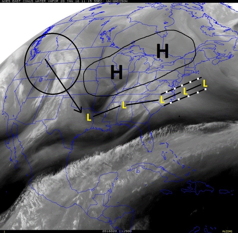 " />
" />Here is where this forecast is still a tad tricky. As you can see by my snowfall map I call it a first call map. The reasoning is that the energy that is our system has only come on shore in the west yesterday, so weather models have only just begun to get much better information about the details of this energy and how it all comes together. In the last 24-36hrs we have seen some shifts in track, intensity, and ultimately outcomes for this system. However, I believe we are finally locking onto a soln, but there is still time for things to shift. I believe at this time only minor shifts will be seen but a shift of only 50-70miles to the track could mean the difference between measuring in inches or feet for some (but not all).
In the satellite image I believe the LP center will take a track somewhere between the lines I have drawn. If the final track is closer to the northern most track then I may need to shift some of my totals up. If the track is closer to the southern track then I may need to shift totals down. I am also looking at the mid level temperatures. For now mid levels all look to be cold enough throughout the storm to support all snow although I cannot rule out brief mixing along the S shore of LI and the Jersey coastline because there is a brief time that the surface temperature goes slightly above freezing. It appears a LP will track to our west on the back side of this system as it pulls out which will bring a warm nose of midlevel air above freezing. I do not, however, think the timing of it is after our system is departing, and do not think it will be significant enough to affect the overall outcome of my thinking.
We still have 3days or so to go. I do expect things to cont to wiggle and wobble regarding the details. The fine tuning of these details, which could lead to big changes in "your" back yard will be sorted out over the next two days. I will have a final call map if needed by Friday.
 " />
" />_________________
"In weather and in life, there's no winning and losing; there's only winning and learning."
WINTER 2012/2013 TOTALS 43.65"WINTER 2017/2018 TOTALS 62.85" WINTER 2022/2023 TOTALS 4.9"
WINTER 2013/2014 TOTALS 64.85"WINTER 2018/2019 TOTALS 14.25" WINTER 2023/2024 TOTALS 13.1"
WINTER 2014/2015 TOTALS 71.20"WINTER 2019/2020 TOTALS 6.35"
WINTER 2015/2016 TOTALS 35.00"WINTER 2020/2021 TOTALS 37.75"
WINTER 2016/2017 TOTALS 42.25"WINTER 2021/2022 TOTALS 31.65"

sroc4- Admin
- Posts : 8331
Reputation : 301
Join date : 2013-01-07
Location : Wading River, LI
Re: 01/22/16 - 01/23/16 Update #3 - Will Models Trend Back North?
![]() by Frank_Wx Wed Jan 20, 2016 8:49 am
by Frank_Wx Wed Jan 20, 2016 8:49 am
_________________
_______________________________________________________________________________________________________
CLICK HERE to view NJ Strong Snowstorm Classifications
Frank_Wx- Godzilla Seeker
- Posts : 21305
Reputation : 328
Join date : 2013-01-05
Age : 31
Location : Jersey City, NJ -
Re: 01/22/16 - 01/23/16 Update #3 - Will Models Trend Back North?
![]() by Frank_Wx Wed Jan 20, 2016 8:52 am
by Frank_Wx Wed Jan 20, 2016 8:52 am
_________________
_______________________________________________________________________________________________________
CLICK HERE to view NJ Strong Snowstorm Classifications
Frank_Wx- Godzilla Seeker
- Posts : 21305
Reputation : 328
Join date : 2013-01-05
Age : 31
Location : Jersey City, NJ -
Re: 01/22/16 - 01/23/16 Update #3 - Will Models Trend Back North?
![]() by weatherwatchermom Wed Jan 20, 2016 8:56 am
by weatherwatchermom Wed Jan 20, 2016 8:56 am
weatherwatchermom- Senior Enthusiast
- Posts : 3750
Reputation : 77
Join date : 2014-11-25
Age : 60
Location : Hazlet Township, NJ
Re: 01/22/16 - 01/23/16 Update #3 - Will Models Trend Back North?
![]() by Frank_Wx Wed Jan 20, 2016 8:56 am
by Frank_Wx Wed Jan 20, 2016 8:56 am
_________________
_______________________________________________________________________________________________________
CLICK HERE to view NJ Strong Snowstorm Classifications
Frank_Wx- Godzilla Seeker
- Posts : 21305
Reputation : 328
Join date : 2013-01-05
Age : 31
Location : Jersey City, NJ -
Re: 01/22/16 - 01/23/16 Update #3 - Will Models Trend Back North?
![]() by weatherwatchermom Wed Jan 20, 2016 9:00 am
by weatherwatchermom Wed Jan 20, 2016 9:00 am
sroc4 wrote:There were many who last week canceled winter and stuck your head in the sand, both posting and silent members. (You know who you are) For those of you who canceled winter last week your penance will be that you have to watch this one from the sidelines. Your flight to Florida will be departing early Friday morning. I have booked a nice hotel just outside the Disney resort where the weather will be sunny and 85*f, perfect for all you winter cancel weenies. The good news is there is free Wi-Fi so you will not be any data charges towards your plan as you monitor the storm.
All kidding aside here it is folks. My first official snow map of the season! If you would like to make a snow map please post it here and one of the moderators will move it into the snow map thread for reference.
A potent piece of upper level energy seen in this satellite currently in the NW CONUS (CONtinental United States), will be diving south and east today into tomorrow. By afternoon time tomorrow it will spawn a surface low pressure center in eastern Texas. The LP center will then track slowly North East from there. By Sat morning into afternoon it will exit the east coast somewhere off the Virginia coastline and cont to track N and East. Snowfall for our coverage area should begin sometime late Friday into very early Sat. from north to south.
Here is where this forecast is still a tad tricky. As you can see by my snowfall map I call it a first call map. The reasoning is that the energy that is our system has only come on shore in the west yesterday, so weather models have only just begun to get much better information about the details of this energy and how it all comes together. In the last 24-36hrs we have seen some shifts in track, intensity, and ultimately outcomes for this system. However, I believe we are finally locking onto a soln, but there is still time for things to shift. I believe at this time only minor shifts will be seen but a shift of only 50-70miles to the track could mean the difference between measuring in inches or feet for some (but not all).
In the satellite image I believe the LP center will take a track somewhere between the lines I have drawn. If the final track is closer to the northern most track then I may need to shift some of my totals up. If the track is closer to the southern track then I may need to shift totals down. I am also looking at the mid level temperatures. For now mid levels all look to be cold enough throughout the storm to support all snow although I cannot rule out brief mixing along the S shore of LI and the Jersey coastline because there is a brief time that the surface temperature goes slightly above freezing. It appears a LP will track to our west on the back side of this system as it pulls out which will bring a warm nose of midlevel air above freezing. I do not, however, think the timing of it is after our system is departing, and do not think it will be significant enough to affect the overall outcome of my thinking.
We still have 3days or so to go. I do expect things to cont to wiggle and wobble regarding the details. The fine tuning of these details, which could lead to big changes in "your" back yard will be sorted out over the next two days. I will have a final call map if needed by Friday.
thanks...
weatherwatchermom- Senior Enthusiast
- Posts : 3750
Reputation : 77
Join date : 2014-11-25
Age : 60
Location : Hazlet Township, NJ
Re: 01/22/16 - 01/23/16 Update #3 - Will Models Trend Back North?
![]() by sroc4 Wed Jan 20, 2016 9:01 am
by sroc4 Wed Jan 20, 2016 9:01 am
Frank_Wx wrote:Scott - read your writeup. I like the first call. I think once we can lock down on an exact track we'll have a better idea. The RH field is very expansive and the jet dynamics should be impressive enough to get meaningful snow accumulations into the NW areas. But until models actually show that more consistently we'll have to play this by ear.
Yeah Frank. I certainly am not going balls to the wall just yet. Im going to do my best today and tomorrow to not get too bothered by any given run that may wobble negatively, or positively. Im going to try and look at the big picture amongst all the models as a whole instead. I felt like we got a pretty good consensus overnight with the timing of when the ULL forms, where it forms, and where it exits the coast. That was key for me. Of course subtle differences in exactly where and how the vorts are handled embedded in the trough will dictate the surface details. But Im pretty confident now in at least everyone getting a healthy fix of the white gold. "Weather" its a kilo or an ounce and for whom is what needs to be determined. See what I did there?
_________________
"In weather and in life, there's no winning and losing; there's only winning and learning."
WINTER 2012/2013 TOTALS 43.65"WINTER 2017/2018 TOTALS 62.85" WINTER 2022/2023 TOTALS 4.9"
WINTER 2013/2014 TOTALS 64.85"WINTER 2018/2019 TOTALS 14.25" WINTER 2023/2024 TOTALS 13.1"
WINTER 2014/2015 TOTALS 71.20"WINTER 2019/2020 TOTALS 6.35"
WINTER 2015/2016 TOTALS 35.00"WINTER 2020/2021 TOTALS 37.75"
WINTER 2016/2017 TOTALS 42.25"WINTER 2021/2022 TOTALS 31.65"
sroc4- Admin
- Posts : 8331
Reputation : 301
Join date : 2013-01-07
Location : Wading River, LI
Re: 01/22/16 - 01/23/16 Update #3 - Will Models Trend Back North?
![]() by oldtimer Wed Jan 20, 2016 9:10 am
by oldtimer Wed Jan 20, 2016 9:10 am
oldtimer- Senior Enthusiast
- Posts : 1103
Reputation : 14
Join date : 2013-01-16
Age : 78
Location : Port Jefferson Station Suffolk County
Re: 01/22/16 - 01/23/16 Update #3 - Will Models Trend Back North?
![]() by jmanley32 Wed Jan 20, 2016 9:11 am
by jmanley32 Wed Jan 20, 2016 9:11 am
Nice map and writeup sroc

jmanley32- Senior Enthusiast
- Posts : 20517
Reputation : 108
Join date : 2013-12-12
Age : 42
Location : Yonkers, NY
Re: 01/22/16 - 01/23/16 Update #3 - Will Models Trend Back North?
![]() by rb924119 Wed Jan 20, 2016 9:17 am
by rb924119 Wed Jan 20, 2016 9:17 am
rb924119- Meteorologist
- Posts : 6890
Reputation : 194
Join date : 2013-02-06
Age : 32
Location : Greentown, Pa
Re: 01/22/16 - 01/23/16 Update #3 - Will Models Trend Back North?
![]() by RJB8525 Wed Jan 20, 2016 9:18 am
by RJB8525 Wed Jan 20, 2016 9:18 am
jmanley32 wrote:1010 WIN around 8am said a foot around city, winds gusting to 55mph beach erosion and coastal flooding. We know how many people listen to 1010 WIN and that's conservative on the snow I think possibly. But the masses are out so let the store packing begin.
Nice map and writeup sroc
well either 1 or 2 things happen lol
1 people will say "Its not gonna snow they know nothing
and 2 "GRAB THE MILK AND BREAD HURRY"
RJB8525- Senior Enthusiast
- Posts : 1994
Reputation : 28
Join date : 2013-02-06
Age : 38
Location : Hackettstown, NJ
Sponsored content
Page 16 of 35 • 1 ... 9 ... 15, 16, 17 ... 25 ... 35 ![]()
|
|
|