
 Search
Long Range Thread 11.0
Page 12 of 27 •  1 ... 7 ... 11, 12, 13 ... 19 ... 27
 ![]()
Re: Long Range Thread 11.0
![]() by algae888 Tue Mar 15, 2016 4:41 pm
by algae888 Tue Mar 15, 2016 4:41 pm
algae888- Advanced Forecaster

- Posts : 5311
Join date : 2013-02-05
Re: Long Range Thread 11.0
![]() by jmanley32 Tue Mar 15, 2016 4:45 pm
by jmanley32 Tue Mar 15, 2016 4:45 pm
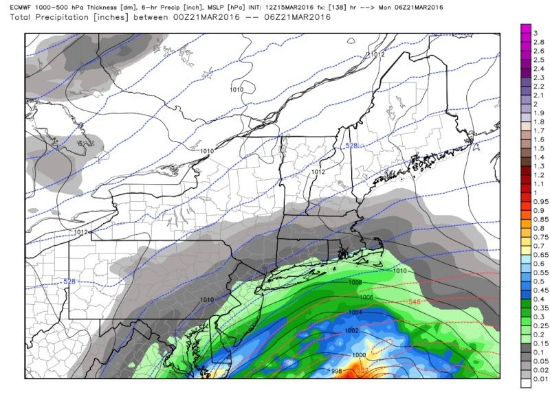
algae888 wrote:Nws going with rain as precip type for coastal areas even with low east of bm.
I can see that happening but this is still 5 days out a ton can and will change as u know Al.
jmanley32- Senior Enthusiast

- Posts : 20516
Join date : 2013-12-12
Re: Long Range Thread 11.0
![]() by algae888 Tue Mar 15, 2016 4:52 pm
by algae888 Tue Mar 15, 2016 4:52 pm
Jman yes. Also hearing euro ens have a lot of nice hits in therejmanley32 wrote:algae888 wrote:Nws going with rain as precip type for coastal areas even with low east of bm.
I can see that happening but this is still 5 days out a ton can and will change as u know Al.

algae888- Advanced Forecaster
- Posts : 5311
Reputation : 46
Join date : 2013-02-05
Age : 61
Location : mt. vernon, new york
Re: Long Range Thread 11.0
![]() by SoulSingMG Tue Mar 15, 2016 4:56 pm
by SoulSingMG Tue Mar 15, 2016 4:56 pm
Euro Ensembles are trending on Twitter; benchmark clustering.

SoulSingMG- Senior Enthusiast
- Posts : 2853
Reputation : 74
Join date : 2013-12-11
Location : Long Island City, NY
Re: Long Range Thread 11.0
![]() by sroc4 Tue Mar 15, 2016 5:19 pm
by sroc4 Tue Mar 15, 2016 5:19 pm
_________________
"In weather and in life, there's no winning and losing; there's only winning and learning."
WINTER 2012/2013 TOTALS 43.65"WINTER 2017/2018 TOTALS 62.85" WINTER 2022/2023 TOTALS 4.9"
WINTER 2013/2014 TOTALS 64.85"WINTER 2018/2019 TOTALS 14.25" WINTER 2023/2024 TOTALS 13.1"
WINTER 2014/2015 TOTALS 71.20"WINTER 2019/2020 TOTALS 6.35"
WINTER 2015/2016 TOTALS 35.00"WINTER 2020/2021 TOTALS 37.75"
WINTER 2016/2017 TOTALS 42.25"WINTER 2021/2022 TOTALS 31.65"

sroc4- Admin

- Posts : 8331
Reputation : 301
Join date : 2013-01-07
Location : Wading River, LI


RJB8525- Senior Enthusiast
- Posts : 1994
Reputation : 28
Join date : 2013-02-06
Age : 38
Location : Hackettstown, NJ
Re: Long Range Thread 11.0
![]() by Frank_Wx Tue Mar 15, 2016 6:48 pm
by Frank_Wx Tue Mar 15, 2016 6:48 pm

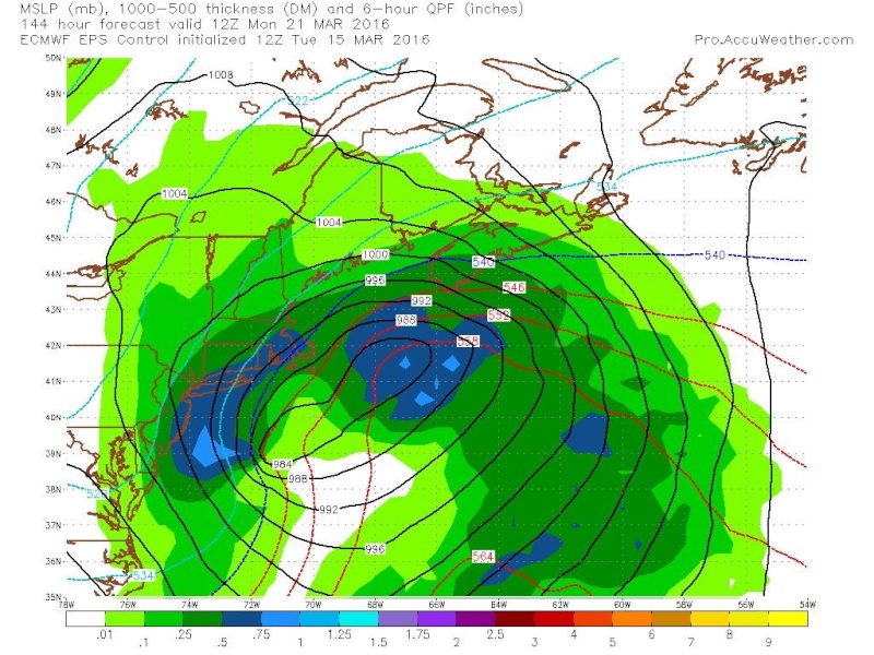
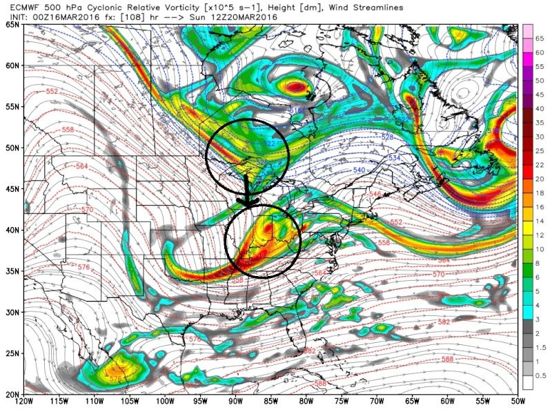
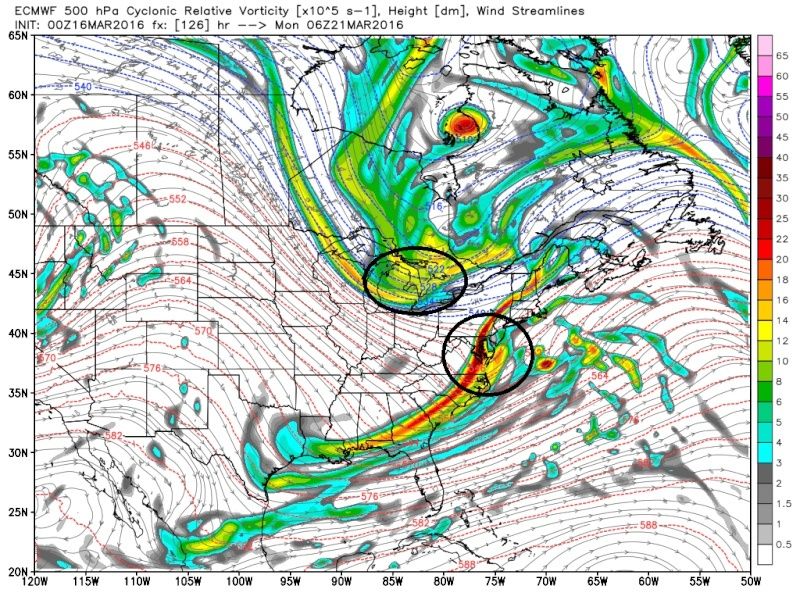
Here is 12z euro OP vort map valid late Sunday. Notice how the southern energy is tucked into the coast as the northern energy tries to catch it. This was initially a closed upper low that broke apart once it approached the coast. A better phase would show a surface low just off the coast with PLENTY of cold air to work with. The northern energy would bring down fresh arctic air as long as it's able to phase. If this was only southern stream driven it would be mainly rain.
Euro OP brushes the area with light snow at this time. The ENS are pretty impressive though. The GFS is progressive as it usually is the case. The setup is not screaming huge EC storm, but it's intriguing and we'll continue to watch it. Understand the threat is there for a sizeable winter storm Sunday into Monday next week.
_________________
_______________________________________________________________________________________________________
CLICK HERE to view NJ Strong Snowstorm Classifications

Frank_Wx- Godzilla Seeker
- Posts : 21305
Reputation : 328
Join date : 2013-01-05
Age : 31
Location : Jersey City, NJ -

Re: Long Range Thread 11.0
![]() by jmanley32 Tue Mar 15, 2016 8:09 pm
by jmanley32 Tue Mar 15, 2016 8:09 pm
bernie is intrigued, thinking the gfs is not showing this right, the 500mb def shows something diff than surface. Yes its old so based on 12z.

jmanley32- Senior Enthusiast
- Posts : 20516
Reputation : 108
Join date : 2013-12-12
Age : 42
Location : Yonkers, NY
SoulSingMG- Senior Enthusiast
- Posts : 2853
Reputation : 74
Join date : 2013-12-11
Location : Long Island City, NY
Re: Long Range Thread 11.0
![]() by jmanley32 Tue Mar 15, 2016 8:16 pm
by jmanley32 Tue Mar 15, 2016 8:16 pm
SoulSingMG wrote:Euro EPS!!!
yes the control brings a 6-12 to the area, less than 00z but still same area.
jmanley32- Senior Enthusiast
- Posts : 20516
Reputation : 108
Join date : 2013-12-12
Age : 42
Location : Yonkers, NY
Re: Long Range Thread 11.0
![]() by jmanley32 Tue Mar 15, 2016 8:19 pm
by jmanley32 Tue Mar 15, 2016 8:19 pm
jmanley32- Senior Enthusiast
- Posts : 20516
Reputation : 108
Join date : 2013-12-12
Age : 42
Location : Yonkers, NY
Re: Long Range Thread 11.0
![]() by Snow88 Tue Mar 15, 2016 11:14 pm
by Snow88 Tue Mar 15, 2016 11:14 pm
March 19-21, 1958
March 20-21, 2016?

Snow88- Senior Enthusiast
- Posts : 2193
Reputation : 4
Join date : 2013-01-09
Age : 35
Location : Brooklyn, NY
Re: Long Range Thread 11.0
![]() by Snow88 Wed Mar 16, 2016 12:00 am
by Snow88 Wed Mar 16, 2016 12:00 am
Snow88- Senior Enthusiast
- Posts : 2193
Reputation : 4
Join date : 2013-01-09
Age : 35
Location : Brooklyn, NY
Snow88- Senior Enthusiast
- Posts : 2193
Reputation : 4
Join date : 2013-01-09
Age : 35
Location : Brooklyn, NY
Re: Long Range Thread 11.0
![]() by sroc4 Wed Mar 16, 2016 7:42 am
by sroc4 Wed Mar 16, 2016 7:42 am
No interaction between two pieces of energy such that by the time the S piece reaches the coast the N piece acts to shunt it OTS.

00z GFS similar, but 06Z there is more interaction; result is a shift west on 06z this morning(hopefully starting this trend:


One of two, or both, things needs to happen. 1) The blocking upstream needs to hold on 12-24hrs longer such that it allows the southern stream to slow enough to allow the two energies to interact and/or 2) The ridging down stream in the west, which looks pretty good already, cont to trend stronger, leading to the N piece digging deeper and phasing into the S piece instead of staying N and acting to shunt the system OTS. As it stands this is going to be yet again very close. Minor changes in the modeling could still have huge implications for better or worse. My first call on the system is to say it looks to be a close call but ultimately swing and miss with maybe eastern most sections being grazed; HOWEVER, with still a lot of time left a more impactful soln is still on the table. With the vast majority of the energy involved about 24-36hrs +/- hrs away from being fully sampled I will cont to monitor and update should it be necessary. If the trends is further OTS I may not say much.
_________________
"In weather and in life, there's no winning and losing; there's only winning and learning."
WINTER 2012/2013 TOTALS 43.65"WINTER 2017/2018 TOTALS 62.85" WINTER 2022/2023 TOTALS 4.9"
WINTER 2013/2014 TOTALS 64.85"WINTER 2018/2019 TOTALS 14.25" WINTER 2023/2024 TOTALS 13.1"
WINTER 2014/2015 TOTALS 71.20"WINTER 2019/2020 TOTALS 6.35"
WINTER 2015/2016 TOTALS 35.00"WINTER 2020/2021 TOTALS 37.75"
WINTER 2016/2017 TOTALS 42.25"WINTER 2021/2022 TOTALS 31.65"
sroc4- Admin
- Posts : 8331
Reputation : 301
Join date : 2013-01-07
Location : Wading River, LI
Re: Long Range Thread 11.0
![]() by weatherwatchermom Wed Mar 16, 2016 9:44 am
by weatherwatchermom Wed Mar 16, 2016 9:44 am
I am attaching Bernie Rayno's take as well
http://videowall.accuweather.com/detail/videos/trending-now/video/2430839568001/last-gasp-of-winter-storm-to-t

weatherwatchermom- Senior Enthusiast
- Posts : 3738
Reputation : 77
Join date : 2014-11-25
Age : 60
Location : Hazlet Township, NJ
Re: Long Range Thread 11.0
![]() by algae888 Wed Mar 16, 2016 10:34 am
by algae888 Wed Mar 16, 2016 10:34 am
algae888- Advanced Forecaster
- Posts : 5311
Reputation : 46
Join date : 2013-02-05
Age : 61
Location : mt. vernon, new york
Re: Long Range Thread 11.0
![]() by sroc4 Wed Mar 16, 2016 11:34 am
by sroc4 Wed Mar 16, 2016 11:34 am
weatherwatchermom wrote:Scott Thank you for the write up!!
I am attaching Bernie Rayno's take as well
http://videowall.accuweather.com/detail/videos/trending-now/video/2430839568001/last-gasp-of-winter-storm-to-t
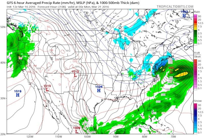
Your welcome. I love his videos. Havent had a chance to watch this mornings yet though. FWIW NAM extrapolated (which I hate doing) looks like there is room for this sytem to come up the coast. Notice how the heights along the EC are much higher relative to the flatter GFS. Look how much further north the 546 line is. This gives room for the surface LP to track more N than E.
GFS:

NAM:

_________________
"In weather and in life, there's no winning and losing; there's only winning and learning."
WINTER 2012/2013 TOTALS 43.65"WINTER 2017/2018 TOTALS 62.85" WINTER 2022/2023 TOTALS 4.9"
WINTER 2013/2014 TOTALS 64.85"WINTER 2018/2019 TOTALS 14.25" WINTER 2023/2024 TOTALS 13.1"
WINTER 2014/2015 TOTALS 71.20"WINTER 2019/2020 TOTALS 6.35"
WINTER 2015/2016 TOTALS 35.00"WINTER 2020/2021 TOTALS 37.75"
WINTER 2016/2017 TOTALS 42.25"WINTER 2021/2022 TOTALS 31.65"
sroc4- Admin
- Posts : 8331
Reputation : 301
Join date : 2013-01-07
Location : Wading River, LI
Re: Long Range Thread 11.0
![]() by nutleyblizzard Wed Mar 16, 2016 12:30 pm
by nutleyblizzard Wed Mar 16, 2016 12:30 pm

nutleyblizzard- Senior Enthusiast
- Posts : 1952
Reputation : 41
Join date : 2014-01-30
Age : 58
Location : Nutley, new jersey
Re: Long Range Thread 11.0
![]() by Dunnzoo Wed Mar 16, 2016 12:34 pm
by Dunnzoo Wed Mar 16, 2016 12:34 pm
_________________
Janet
Snowfall winter of 2023-2024 17.5"
Snowfall winter of 2022-2023 6.0"
Snowfall winter of 2021-2022 17.6" 1" sleet 2/25/22
Snowfall winter of 2020-2021 51.1"
Snowfall winter of 2019-2020 8.5"
Snowfall winter of 2018-2019 25.1"
Snowfall winter of 2017-2018 51.9"
Snowfall winter of 2016-2017 45.6"
Snowfall winter of 2015-2016 29.5"
Snowfall winter of 2014-2015 50.55"
Snowfall winter of 2013-2014 66.5"

Dunnzoo- Senior Enthusiast - Mod

- Posts : 4891
Reputation : 68
Join date : 2013-01-11
Age : 62
Location : Westwood, NJ
Re: Long Range Thread 11.0
![]() by algae888 Wed Mar 16, 2016 12:38 pm
by algae888 Wed Mar 16, 2016 12:38 pm
algae888- Advanced Forecaster
- Posts : 5311
Reputation : 46
Join date : 2013-02-05
Age : 61
Location : mt. vernon, new york
Re: Long Range Thread 11.0
![]() by algae888 Wed Mar 16, 2016 12:50 pm
by algae888 Wed Mar 16, 2016 12:50 pm
Edit 1006 MB right on the South Carolina coast at hour 96 977 Mb just Northwest of Cape Cod in the southern and Eastern Gulf of Maine so how to figure when it bombs out if it's south of us East of us or north of us but great run
Last edited by algae888 on Wed Mar 16, 2016 12:54 pm; edited 2 times in total
algae888- Advanced Forecaster
- Posts : 5311
Reputation : 46
Join date : 2013-02-05
Age : 61
Location : mt. vernon, new york
Re: Long Range Thread 11.0
![]() by jmanley32 Wed Mar 16, 2016 12:52 pm
by jmanley32 Wed Mar 16, 2016 12:52 pm
jmanley32- Senior Enthusiast
- Posts : 20516
Reputation : 108
Join date : 2013-12-12
Age : 42
Location : Yonkers, NY
Re: Long Range Thread 11.0
![]() by jmanley32 Wed Mar 16, 2016 12:53 pm
by jmanley32 Wed Mar 16, 2016 12:53 pm
jmanley32- Senior Enthusiast
- Posts : 20516
Reputation : 108
Join date : 2013-12-12
Age : 42
Location : Yonkers, NY
Re: Long Range Thread 11.0
![]() by algae888 Wed Mar 16, 2016 12:55 pm
by algae888 Wed Mar 16, 2016 12:55 pm
Jman also precipitation shield on the Western and Northern flank doesn't look right it should be more expensive with the low that strength so close to Eastern Long Islandjmanley32 wrote:Well is 968 at its lowest off cape cod, 980 south of LI.
algae888- Advanced Forecaster
- Posts : 5311
Reputation : 46
Join date : 2013-02-05
Age : 61
Location : mt. vernon, new york
Re: Long Range Thread 11.0
![]() by jmanley32 Wed Mar 16, 2016 12:56 pm
by jmanley32 Wed Mar 16, 2016 12:56 pm
jmanley32- Senior Enthusiast
- Posts : 20516
Reputation : 108
Join date : 2013-12-12
Age : 42
Location : Yonkers, NY
Re: Long Range Thread 11.0
![]() by sroc4 Wed Mar 16, 2016 12:56 pm
by sroc4 Wed Mar 16, 2016 12:56 pm
_________________
"In weather and in life, there's no winning and losing; there's only winning and learning."
WINTER 2012/2013 TOTALS 43.65"WINTER 2017/2018 TOTALS 62.85" WINTER 2022/2023 TOTALS 4.9"
WINTER 2013/2014 TOTALS 64.85"WINTER 2018/2019 TOTALS 14.25" WINTER 2023/2024 TOTALS 13.1"
WINTER 2014/2015 TOTALS 71.20"WINTER 2019/2020 TOTALS 6.35"
WINTER 2015/2016 TOTALS 35.00"WINTER 2020/2021 TOTALS 37.75"
WINTER 2016/2017 TOTALS 42.25"WINTER 2021/2022 TOTALS 31.65"
sroc4- Admin
- Posts : 8331
Reputation : 301
Join date : 2013-01-07
Location : Wading River, LI
Page 12 of 27 • 1 ... 7 ... 11, 12, 13 ... 19 ... 27 ![]()
|
|
|