
 Search
2016 Tropical Cyclone Discussions
Page 10 of 33 •  1 ... 6 ... 9, 10, 11 ... 21 ... 33
 ![]()
Re: 2016 Tropical Cyclone Discussions
![]() by Frank_Wx Tue Aug 23, 2016 10:56 pm
by Frank_Wx Tue Aug 23, 2016 10:56 pm

Frank_Wx- Godzilla Seeker

- Posts : 21305
Join date : 2013-01-05 -

Re: 2016 Tropical Cyclone Discussions
![]() by Snow88 Tue Aug 23, 2016 11:05 pm
by Snow88 Tue Aug 23, 2016 11:05 pm
Snow88- Senior Enthusiast

- Posts : 2193
Join date : 2013-01-09
Re: 2016 Tropical Cyclone Discussions
![]() by jmanley32 Tue Aug 23, 2016 11:09 pm
by jmanley32 Tue Aug 23, 2016 11:09 pm
the euro showed a ton of rain and strong ts force conditions with verbatim gusts 70 plus. But tgats a big if. It depends obviously on how soon the recurve happens how much land interaction or if it's ots cuz it's far enpugh east.Snow88 wrote:Frank_Wx wrote:Snow88 wrote:As of right now, this doesnt look to have a big impact on the east coast
This was never an east coast threat. We're going to end up with temps in the 90s this weekend thanks to that ridge. That said, if invest 99 does become a hurricane and tracks into the Gulf, we can't rule out a recurve of its remnants heading this way
Like the Euro
7
6+ inches of rain for the area

jmanley32- Senior Enthusiast
- Posts : 20513
Reputation : 108
Join date : 2013-12-12
Age : 42
Location : Yonkers, NY
Re: 2016 Tropical Cyclone Discussions
![]() by jmanley32 Tue Aug 23, 2016 11:10 pm
by jmanley32 Tue Aug 23, 2016 11:10 pm
jmanley32- Senior Enthusiast
- Posts : 20513
Reputation : 108
Join date : 2013-12-12
Age : 42
Location : Yonkers, NY
Re: 2016 Tropical Cyclone Discussions
![]() by NjWeatherGuy Tue Aug 23, 2016 11:47 pm
by NjWeatherGuy Tue Aug 23, 2016 11:47 pm

NjWeatherGuy- Advanced Forecaster

- Posts : 4100
Reputation : 28
Join date : 2013-01-06
Location : Belle Mead, NJ
Re: 2016 Tropical Cyclone Discussions
![]() by Joe Snow Wed Aug 24, 2016 12:47 am
by Joe Snow Wed Aug 24, 2016 12:47 am

Joe Snow- Pro Enthusiast

- Posts : 924
Reputation : 7
Join date : 2014-02-12
Age : 62
Location : Sanford Florida, Fmrly Kings Park, NY

Joe Snow- Pro Enthusiast
- Posts : 924
Reputation : 7
Join date : 2014-02-12
Age : 62
Location : Sanford Florida, Fmrly Kings Park, NY
Re: 2016 Tropical Cyclone Discussions
![]() by jmanley32 Wed Aug 24, 2016 5:50 am
by jmanley32 Wed Aug 24, 2016 5:50 am
jmanley32- Senior Enthusiast
- Posts : 20513
Reputation : 108
Join date : 2013-12-12
Age : 42
Location : Yonkers, NY
Re: 2016 Tropical Cyclone Discussions
![]() by Frank_Wx Wed Aug 24, 2016 5:54 am
by Frank_Wx Wed Aug 24, 2016 5:54 am

_________________
_______________________________________________________________________________________________________
CLICK HERE to view NJ Strong Snowstorm Classifications

Frank_Wx- Godzilla Seeker
- Posts : 21305
Reputation : 328
Join date : 2013-01-05
Age : 31
Location : Jersey City, NJ -
Re: 2016 Tropical Cyclone Discussions
![]() by sroc4 Wed Aug 24, 2016 6:57 am
by sroc4 Wed Aug 24, 2016 6:57 am


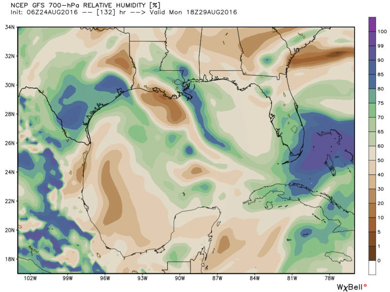

Regarding track with the consistency in the modeling regarding the weakness in the ridge over the Rockies and positioning of the ridge off the EC a more westward track into the GOM under the ridge without question seems more likely to me vs the quickly recurving soln and re-emergence of the EC the 00z GFS showed last night.
_________________
"In weather and in life, there's no winning and losing; there's only winning and learning."
WINTER 2012/2013 TOTALS 43.65"WINTER 2017/2018 TOTALS 62.85" WINTER 2022/2023 TOTALS 4.9"
WINTER 2013/2014 TOTALS 64.85"WINTER 2018/2019 TOTALS 14.25" WINTER 2023/2024 TOTALS 13.1"
WINTER 2014/2015 TOTALS 71.20"WINTER 2019/2020 TOTALS 6.35"
WINTER 2015/2016 TOTALS 35.00"WINTER 2020/2021 TOTALS 37.75"
WINTER 2016/2017 TOTALS 42.25"WINTER 2021/2022 TOTALS 31.65"

sroc4- Admin
- Posts : 8331
Reputation : 301
Join date : 2013-01-07
Location : Wading River, LI
Re: 2016 Tropical Cyclone Discussions
![]() by nutleyblizzard Wed Aug 24, 2016 7:08 am
by nutleyblizzard Wed Aug 24, 2016 7:08 am

nutleyblizzard- Senior Enthusiast
- Posts : 1952
Reputation : 41
Join date : 2014-01-30
Age : 58
Location : Nutley, new jersey
Re: 2016 Tropical Cyclone Discussions
![]() by sroc4 Wed Aug 24, 2016 8:59 am
by sroc4 Wed Aug 24, 2016 8:59 am
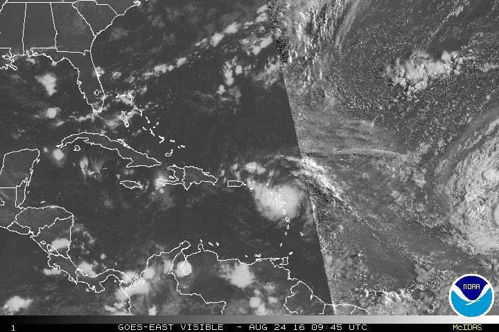
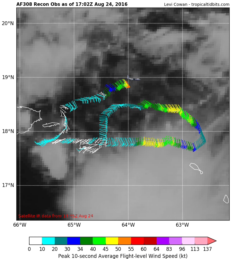
https://earth.nullschool.net/#current/wind/surface/level/orthographic=-64.89,17.31,3000
There is still a modest amt of wind shear from west to east North of PR(red lines) and the Greater Antilles and the BVI. This is preventing the convection from centering over top the LLC which is needed.
There is however an anticyclone in the upper levels just to the south of the LLC and just to the west of where the best convection is.

99l still has some work to do, but it is holding strong given the conditions. Need that LLC to head WNW to NW to avoid going right over PR which I believe it will. Next 24-48 hrs holds a major key to the outcome of this system.
_________________
"In weather and in life, there's no winning and losing; there's only winning and learning."
WINTER 2012/2013 TOTALS 43.65"WINTER 2017/2018 TOTALS 62.85" WINTER 2022/2023 TOTALS 4.9"
WINTER 2013/2014 TOTALS 64.85"WINTER 2018/2019 TOTALS 14.25" WINTER 2023/2024 TOTALS 13.1"
WINTER 2014/2015 TOTALS 71.20"WINTER 2019/2020 TOTALS 6.35"
WINTER 2015/2016 TOTALS 35.00"WINTER 2020/2021 TOTALS 37.75"
WINTER 2016/2017 TOTALS 42.25"WINTER 2021/2022 TOTALS 31.65"
sroc4- Admin
- Posts : 8331
Reputation : 301
Join date : 2013-01-07
Location : Wading River, LI
Re: 2016 Tropical Cyclone Discussions
![]() by jmanley32 Wed Aug 24, 2016 9:09 am
by jmanley32 Wed Aug 24, 2016 9:09 am
jmanley32- Senior Enthusiast
- Posts : 20513
Reputation : 108
Join date : 2013-12-12
Age : 42
Location : Yonkers, NY
Re: 2016 Tropical Cyclone Discussions
![]() by Dunnzoo Wed Aug 24, 2016 9:29 am
by Dunnzoo Wed Aug 24, 2016 9:29 am
_________________
Janet
Snowfall winter of 2023-2024 17.5"
Snowfall winter of 2022-2023 6.0"
Snowfall winter of 2021-2022 17.6" 1" sleet 2/25/22
Snowfall winter of 2020-2021 51.1"
Snowfall winter of 2019-2020 8.5"
Snowfall winter of 2018-2019 25.1"
Snowfall winter of 2017-2018 51.9"
Snowfall winter of 2016-2017 45.6"
Snowfall winter of 2015-2016 29.5"
Snowfall winter of 2014-2015 50.55"
Snowfall winter of 2013-2014 66.5"

Dunnzoo- Senior Enthusiast - Mod

- Posts : 4887
Reputation : 68
Join date : 2013-01-11
Age : 62
Location : Westwood, NJ
Re: 2016 Tropical Cyclone Discussions
![]() by amugs Wed Aug 24, 2016 10:02 am
by amugs Wed Aug 24, 2016 10:02 am

If it hits Hispanolia it will be shredded by the mountains and becomes nada.
Fun tracking these beasts!!
_________________
Mugs
AKA:King: Snow Weenie
Self Proclaimed
WINTER 2014-15 : 55.12" +.02 for 6 coatings (avg. 35")
WINTER 2015-16 Total - 29.8" (Avg 35")
WINTER 2016-17 : 39.5" so far

amugs- Advanced Forecaster - Mod
- Posts : 15093
Reputation : 213
Join date : 2013-01-07
Age : 54
Location : Hillsdale,NJ
Re: 2016 Tropical Cyclone Discussions
![]() by aiannone Wed Aug 24, 2016 10:28 am
by aiannone Wed Aug 24, 2016 10:28 am
_________________
-Alex Iannone-

aiannone- Senior Enthusiast - Mod
- Posts : 4813
Reputation : 92
Join date : 2013-01-07
Location : Saint James, LI (Northwest Suffolk Co.)
Re: 2016 Tropical Cyclone Discussions
![]() by amugs Wed Aug 24, 2016 10:56 am
by amugs Wed Aug 24, 2016 10:56 am

_________________
Mugs
AKA:King: Snow Weenie
Self Proclaimed
WINTER 2014-15 : 55.12" +.02 for 6 coatings (avg. 35")
WINTER 2015-16 Total - 29.8" (Avg 35")
WINTER 2016-17 : 39.5" so far
amugs- Advanced Forecaster - Mod
- Posts : 15093
Reputation : 213
Join date : 2013-01-07
Age : 54
Location : Hillsdale,NJ
Re: 2016 Tropical Cyclone Discussions
![]() by sroc4 Wed Aug 24, 2016 11:00 am
by sroc4 Wed Aug 24, 2016 11:00 am
aiannone wrote:Hey guys!
Alex!
_________________
"In weather and in life, there's no winning and losing; there's only winning and learning."
WINTER 2012/2013 TOTALS 43.65"WINTER 2017/2018 TOTALS 62.85" WINTER 2022/2023 TOTALS 4.9"
WINTER 2013/2014 TOTALS 64.85"WINTER 2018/2019 TOTALS 14.25" WINTER 2023/2024 TOTALS 13.1"
WINTER 2014/2015 TOTALS 71.20"WINTER 2019/2020 TOTALS 6.35"
WINTER 2015/2016 TOTALS 35.00"WINTER 2020/2021 TOTALS 37.75"
WINTER 2016/2017 TOTALS 42.25"WINTER 2021/2022 TOTALS 31.65"
sroc4- Admin
- Posts : 8331
Reputation : 301
Join date : 2013-01-07
Location : Wading River, LI
Re: 2016 Tropical Cyclone Discussions
![]() by aiannone Wed Aug 24, 2016 11:04 am
by aiannone Wed Aug 24, 2016 11:04 am
_________________
-Alex Iannone-
aiannone- Senior Enthusiast - Mod
- Posts : 4813
Reputation : 92
Join date : 2013-01-07
Location : Saint James, LI (Northwest Suffolk Co.)
Re: 2016 Tropical Cyclone Discussions
![]() by jmanley32 Wed Aug 24, 2016 12:02 pm
by jmanley32 Wed Aug 24, 2016 12:02 pm
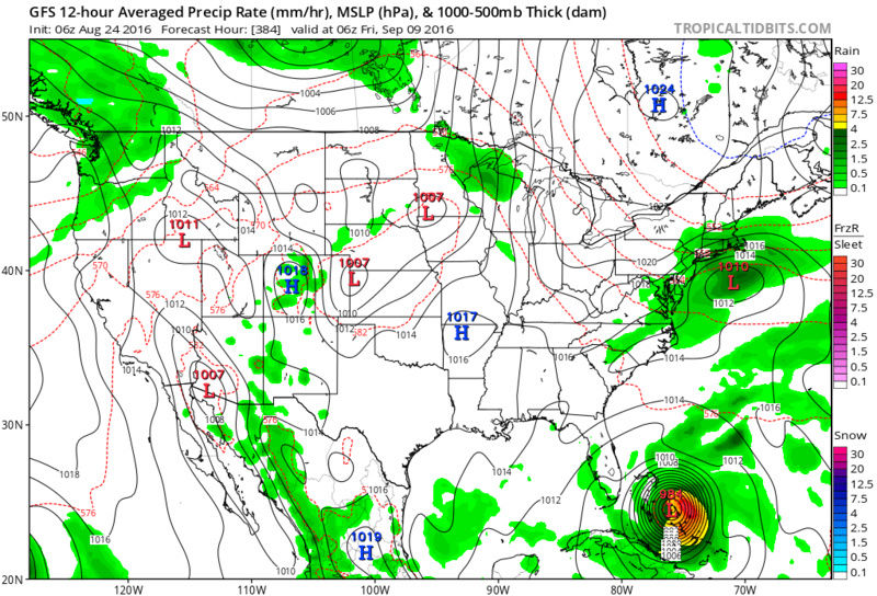
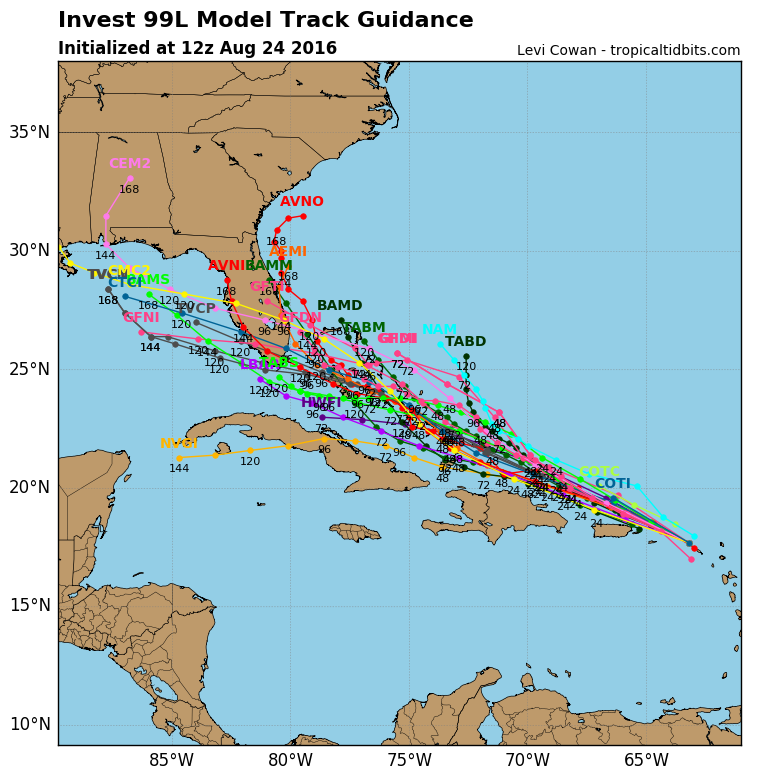
On another note check this out....Both GFS and Euro have it, at this far out that's not really good,
jmanley32- Senior Enthusiast
- Posts : 20513
Reputation : 108
Join date : 2013-12-12
Age : 42
Location : Yonkers, NY
Re: 2016 Tropical Cyclone Discussions
![]() by sroc4 Wed Aug 24, 2016 12:25 pm
by sroc4 Wed Aug 24, 2016 12:25 pm
_________________
"In weather and in life, there's no winning and losing; there's only winning and learning."
WINTER 2012/2013 TOTALS 43.65"WINTER 2017/2018 TOTALS 62.85" WINTER 2022/2023 TOTALS 4.9"
WINTER 2013/2014 TOTALS 64.85"WINTER 2018/2019 TOTALS 14.25" WINTER 2023/2024 TOTALS 13.1"
WINTER 2014/2015 TOTALS 71.20"WINTER 2019/2020 TOTALS 6.35"
WINTER 2015/2016 TOTALS 35.00"WINTER 2020/2021 TOTALS 37.75"
WINTER 2016/2017 TOTALS 42.25"WINTER 2021/2022 TOTALS 31.65"
sroc4- Admin
- Posts : 8331
Reputation : 301
Join date : 2013-01-07
Location : Wading River, LI
Re: 2016 Tropical Cyclone Discussions
![]() by Snow88 Wed Aug 24, 2016 12:42 pm
by Snow88 Wed Aug 24, 2016 12:42 pm
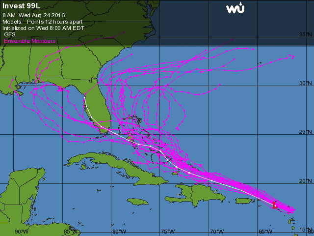
sroc4 wrote:Either the GFS is completely lost or it scores the coup.
GFS has been trending west with Gaston. Maybe Gaston is messing up 99L on the runs.

Snow88- Senior Enthusiast
- Posts : 2193
Reputation : 4
Join date : 2013-01-09
Age : 35
Location : Brooklyn, NY
Re: 2016 Tropical Cyclone Discussions
![]() by jmanley32 Wed Aug 24, 2016 1:10 pm
by jmanley32 Wed Aug 24, 2016 1:10 pm
jmanley32- Senior Enthusiast
- Posts : 20513
Reputation : 108
Join date : 2013-12-12
Age : 42
Location : Yonkers, NY
Re: 2016 Tropical Cyclone Discussions
![]() by Snow88 Wed Aug 24, 2016 1:10 pm
by Snow88 Wed Aug 24, 2016 1:10 pm
Could Gaston play a roll?
Snow88- Senior Enthusiast
- Posts : 2193
Reputation : 4
Join date : 2013-01-09
Age : 35
Location : Brooklyn, NY
Re: 2016 Tropical Cyclone Discussions
![]() by jmanley32 Wed Aug 24, 2016 1:12 pm
by jmanley32 Wed Aug 24, 2016 1:12 pm
jmanley32- Senior Enthusiast
- Posts : 20513
Reputation : 108
Join date : 2013-12-12
Age : 42
Location : Yonkers, NY
Re: 2016 Tropical Cyclone Discussions
![]() by jmanley32 Wed Aug 24, 2016 1:13 pm
by jmanley32 Wed Aug 24, 2016 1:13 pm
Snow88 wrote:Ukie is more east and weaker on the `12z run
Could Gaston play a roll?
Gaston was much further west on runs, but I don't believe he will get to Bermuda west or even further, but that could def keep 99L going more west or maybe even a bit North. And that ridge, seems to be changing on its intensity from run to run. Def complex setup here and zeroing in on 5 days or less not a whole lot of time, this could well pull a fast on on the US, or not.
jmanley32- Senior Enthusiast
- Posts : 20513
Reputation : 108
Join date : 2013-12-12
Age : 42
Location : Yonkers, NY
Re: 2016 Tropical Cyclone Discussions
![]() by jmanley32 Wed Aug 24, 2016 1:17 pm
by jmanley32 Wed Aug 24, 2016 1:17 pm
Recon mission so far, def plenty TS winds.
jmanley32- Senior Enthusiast
- Posts : 20513
Reputation : 108
Join date : 2013-12-12
Age : 42
Location : Yonkers, NY
Page 10 of 33 • 1 ... 6 ... 9, 10, 11 ... 21 ... 33 ![]()
|
|
|