
 Search
Hurricane Hermine Discussion
Page 1 of 40 • 1, 2, 3 ... 20 ... 40 ![]()

Hurricane Hermine Discussion
![]() by Frank_Wx Sun Aug 28, 2016 2:27 pm
by Frank_Wx Sun Aug 28, 2016 2:27 pm
https://flightaware.com/live/flight/NOAA43
The Canadian and some of the hurricane models are the only guidances' strengthening 99L into Hurricane Helene.

Regardless of its intensity, I do NOT expect tropical rains associated with this system to make it into our area. The DC area and southern NJ may see some rain, but I think we remain dry all of this week into the weekend.
If 99L remains unnamed, that means the African wave we are tracking for September 10th period will be Helene.
Last edited by Frank_Wx on Thu Sep 01, 2016 4:47 pm; edited 1 time in total
_________________
_______________________________________________________________________________________________________
CLICK HERE to view NJ Strong Snowstorm Classifications

Frank_Wx- Godzilla Seeker

- Posts : 21305
Reputation : 328
Join date : 2013-01-05
Age : 31
Location : Jersey City, NJ -

Re: Hurricane Hermine Discussion
![]() by Frank_Wx Sun Aug 28, 2016 2:31 pm
by Frank_Wx Sun Aug 28, 2016 2:31 pm
_________________
_______________________________________________________________________________________________________
CLICK HERE to view NJ Strong Snowstorm Classifications
Frank_Wx- Godzilla Seeker
- Posts : 21305
Reputation : 328
Join date : 2013-01-05
Age : 31
Location : Jersey City, NJ -
Re: Hurricane Hermine Discussion
![]() by Frank_Wx Sun Aug 28, 2016 2:32 pm
by Frank_Wx Sun Aug 28, 2016 2:32 pm
As far as 99L 12 days and fighting its way toward area normally favorable with very warm water argues for development
— Joe Bastardi (@BigJoeBastardi) August 28, 2016
_________________
_______________________________________________________________________________________________________
CLICK HERE to view NJ Strong Snowstorm Classifications
Frank_Wx- Godzilla Seeker
- Posts : 21305
Reputation : 328
Join date : 2013-01-05
Age : 31
Location : Jersey City, NJ -
Re: Hurricane Hermine Discussion
![]() by jmanley32 Sun Aug 28, 2016 3:04 pm
by jmanley32 Sun Aug 28, 2016 3:04 pm

jmanley32- Senior Enthusiast

- Posts : 20513
Reputation : 108
Join date : 2013-12-12
Age : 42
Location : Yonkers, NY
Re: Hurricane Hermine Discussion
![]() by jmanley32 Sun Aug 28, 2016 3:04 pm
by jmanley32 Sun Aug 28, 2016 3:04 pm
No kidding right, you would think with the technology and proximity to land we would know more, I mean if this did explode that would be really bad for any planning.Frank_Wx wrote:Joe Bastardi tweeted he has never seen the EURO this bad. Going from a strong Hurricane to a weak invest in a 12 hour span. Until we get the Hurricane Hunter data recon, we really have no clue. Must be frustrating living in Florida or AL/GA and not knowing what's happening 2 days from now...
jmanley32- Senior Enthusiast
- Posts : 20513
Reputation : 108
Join date : 2013-12-12
Age : 42
Location : Yonkers, NY
Re: Hurricane Hermine Discussion
![]() by sroc4 Sun Aug 28, 2016 4:06 pm
by sroc4 Sun Aug 28, 2016 4:06 pm
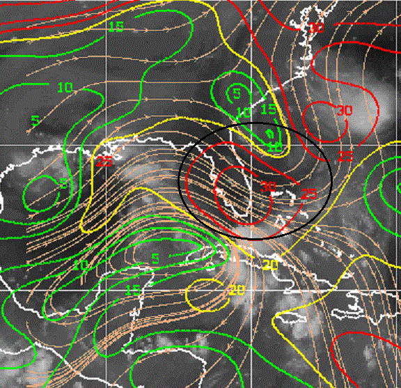

Latest recon is now showing what looks to me to be a clearly closed low level circulation with west winds on the south side of the LP center. This could be big because in the next 24hrs both GFS and Euro forecasts an upper level anticyclone over top of the LP center as it moves into the GOM. If the shear lets up at all this could still ramp up quickly. I don't care what models say today I agree with JB. This whole thing screams rapid development still. The only thing to hold it back has got to be the shear if it persists stronger than forecast, which it has done all along. Should be very interesting to see if they upgrade to a TD with current recon data showing a closed LLC and what the 00z's tonight show with the new data.

_________________
"In weather and in life, there's no winning and losing; there's only winning and learning."
WINTER 2012/2013 TOTALS 43.65"WINTER 2017/2018 TOTALS 62.85" WINTER 2022/2023 TOTALS 4.9"
WINTER 2013/2014 TOTALS 64.85"WINTER 2018/2019 TOTALS 14.25" WINTER 2023/2024 TOTALS 13.1"
WINTER 2014/2015 TOTALS 71.20"WINTER 2019/2020 TOTALS 6.35"
WINTER 2015/2016 TOTALS 35.00"WINTER 2020/2021 TOTALS 37.75"
WINTER 2016/2017 TOTALS 42.25"WINTER 2021/2022 TOTALS 31.65"

sroc4- Admin
- Posts : 8331
Reputation : 301
Join date : 2013-01-07
Location : Wading River, LI
Re: Hurricane Hermine Discussion
![]() by sroc4 Sun Aug 28, 2016 4:13 pm
by sroc4 Sun Aug 28, 2016 4:13 pm
_________________
"In weather and in life, there's no winning and losing; there's only winning and learning."
WINTER 2012/2013 TOTALS 43.65"WINTER 2017/2018 TOTALS 62.85" WINTER 2022/2023 TOTALS 4.9"
WINTER 2013/2014 TOTALS 64.85"WINTER 2018/2019 TOTALS 14.25" WINTER 2023/2024 TOTALS 13.1"
WINTER 2014/2015 TOTALS 71.20"WINTER 2019/2020 TOTALS 6.35"
WINTER 2015/2016 TOTALS 35.00"WINTER 2020/2021 TOTALS 37.75"
WINTER 2016/2017 TOTALS 42.25"WINTER 2021/2022 TOTALS 31.65"
sroc4- Admin
- Posts : 8331
Reputation : 301
Join date : 2013-01-07
Location : Wading River, LI
Re: Hurricane Hermine Discussion
![]() by jmanley32 Sun Aug 28, 2016 4:49 pm
by jmanley32 Sun Aug 28, 2016 4:49 pm
jmanley32- Senior Enthusiast
- Posts : 20513
Reputation : 108
Join date : 2013-12-12
Age : 42
Location : Yonkers, NY
Re: Hurricane Hermine Discussion
![]() by jmanley32 Sun Aug 28, 2016 4:51 pm
by jmanley32 Sun Aug 28, 2016 4:51 pm
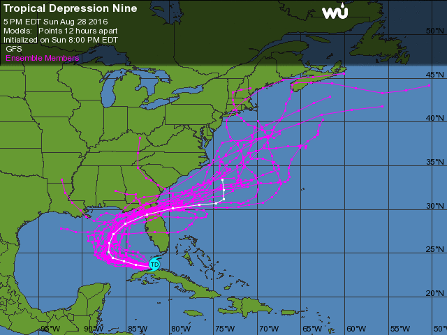
5:00 PM EDT Sun Aug 28
Location: 23.7°N 81.7°W
Moving: W at 9 mph
Min pressure: 1009 mb
Max sustained: 35 mph
Someone change title of the thread to TD 9 maybe?
jmanley32- Senior Enthusiast
- Posts : 20513
Reputation : 108
Join date : 2013-12-12
Age : 42
Location : Yonkers, NY

jmanley32- Senior Enthusiast
- Posts : 20513
Reputation : 108
Join date : 2013-12-12
Age : 42
Location : Yonkers, NY
Re: Hurricane Hermine Discussion
![]() by Frank_Wx Sun Aug 28, 2016 5:19 pm
by Frank_Wx Sun Aug 28, 2016 5:19 pm
_________________
_______________________________________________________________________________________________________
CLICK HERE to view NJ Strong Snowstorm Classifications
Frank_Wx- Godzilla Seeker
- Posts : 21305
Reputation : 328
Join date : 2013-01-05
Age : 31
Location : Jersey City, NJ -
Re: Hurricane Hermine Discussion
![]() by Frank_Wx Sun Aug 28, 2016 5:27 pm
by Frank_Wx Sun Aug 28, 2016 5:27 pm

There's an upper level low over FL that is inhibiting TD 9 with dry air and shear on the northern quadrant (like Scott said). There's another ULL over western GOM. It's no wonder models are struggling with how strong TD 9 may get. Some have the wave interacting too much with these upper lows. Some have it avoid the interaction and it strengthens under the anticyclonic flow.
_________________
_______________________________________________________________________________________________________
CLICK HERE to view NJ Strong Snowstorm Classifications
Frank_Wx- Godzilla Seeker
- Posts : 21305
Reputation : 328
Join date : 2013-01-05
Age : 31
Location : Jersey City, NJ -
Re: Hurricane Hermine Discussion
![]() by Frank_Wx Sun Aug 28, 2016 5:55 pm
by Frank_Wx Sun Aug 28, 2016 5:55 pm

_________________
_______________________________________________________________________________________________________
CLICK HERE to view NJ Strong Snowstorm Classifications
Frank_Wx- Godzilla Seeker
- Posts : 21305
Reputation : 328
Join date : 2013-01-05
Age : 31
Location : Jersey City, NJ -
Re: Hurricane Hermine Discussion
![]() by jmanley32 Sun Aug 28, 2016 6:51 pm
by jmanley32 Sun Aug 28, 2016 6:51 pm
jmanley32- Senior Enthusiast
- Posts : 20513
Reputation : 108
Join date : 2013-12-12
Age : 42
Location : Yonkers, NY
Re: Hurricane Hermine Discussion
![]() by sroc4 Sun Aug 28, 2016 8:10 pm
by sroc4 Sun Aug 28, 2016 8:10 pm
_________________
"In weather and in life, there's no winning and losing; there's only winning and learning."
WINTER 2012/2013 TOTALS 43.65"WINTER 2017/2018 TOTALS 62.85" WINTER 2022/2023 TOTALS 4.9"
WINTER 2013/2014 TOTALS 64.85"WINTER 2018/2019 TOTALS 14.25" WINTER 2023/2024 TOTALS 13.1"
WINTER 2014/2015 TOTALS 71.20"WINTER 2019/2020 TOTALS 6.35"
WINTER 2015/2016 TOTALS 35.00"WINTER 2020/2021 TOTALS 37.75"
WINTER 2016/2017 TOTALS 42.25"WINTER 2021/2022 TOTALS 31.65"
sroc4- Admin
- Posts : 8331
Reputation : 301
Join date : 2013-01-07
Location : Wading River, LI
Re: Hurricane Hermine Discussion
![]() by Joe Snow Sun Aug 28, 2016 9:49 pm
by Joe Snow Sun Aug 28, 2016 9:49 pm
Frank_Wx wrote:Holy crap it's finally a TD. Felt like years.
I have to say 99L had a lot of heart it hung in there, as the saying goes Never Quit!!!

Joe Snow- Pro Enthusiast

- Posts : 924
Reputation : 7
Join date : 2014-02-12
Age : 62
Location : Sanford Florida, Fmrly Kings Park, NY
Re: Hurricane Hermine Discussion
![]() by jmanley32 Sun Aug 28, 2016 9:58 pm
by jmanley32 Sun Aug 28, 2016 9:58 pm
jmanley32- Senior Enthusiast
- Posts : 20513
Reputation : 108
Join date : 2013-12-12
Age : 42
Location : Yonkers, NY
Re: Hurricane Hermine Discussion
![]() by Joe Snow Sun Aug 28, 2016 10:00 pm
by Joe Snow Sun Aug 28, 2016 10:00 pm
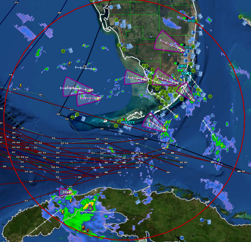
This is the Current Radar from Key Biscayne
Joe Snow- Pro Enthusiast
- Posts : 924
Reputation : 7
Join date : 2014-02-12
Age : 62
Location : Sanford Florida, Fmrly Kings Park, NY
Re: Hurricane Hermine Discussion
![]() by jmanley32 Sun Aug 28, 2016 10:02 pm
by jmanley32 Sun Aug 28, 2016 10:02 pm
Joe Snow wrote:
This is the Current Radar from Key Biscayne
Doesn't look like much, having a hard time seeing anything but a big mess on sattelite. I have seen better invests. LOL
jmanley32- Senior Enthusiast
- Posts : 20513
Reputation : 108
Join date : 2013-12-12
Age : 42
Location : Yonkers, NY
Re: Hurricane Hermine Discussion
![]() by jmanley32 Sun Aug 28, 2016 10:04 pm
by jmanley32 Sun Aug 28, 2016 10:04 pm
jmanley32- Senior Enthusiast
- Posts : 20513
Reputation : 108
Join date : 2013-12-12
Age : 42
Location : Yonkers, NY
Re: Hurricane Hermine Discussion
![]() by jmanley32 Sun Aug 28, 2016 10:06 pm
by jmanley32 Sun Aug 28, 2016 10:06 pm

jmanley32- Senior Enthusiast
- Posts : 20513
Reputation : 108
Join date : 2013-12-12
Age : 42
Location : Yonkers, NY
Re: Hurricane Hermine Discussion
![]() by NjWeatherGuy Mon Aug 29, 2016 2:45 am
by NjWeatherGuy Mon Aug 29, 2016 2:45 am

NjWeatherGuy- Advanced Forecaster

- Posts : 4100
Reputation : 28
Join date : 2013-01-06
Location : Belle Mead, NJ
Re: Hurricane Hermine Discussion
![]() by sroc4 Mon Aug 29, 2016 7:13 am
by sroc4 Mon Aug 29, 2016 7:13 am


Models are in pretty good agreement showing how the mid levels cont to be influenced by first the ULL in the NW GOM, and then a bigger positively tilted trough digs deeper into the NE which eventually triggers the N then NE turn. This deep pos tilted trough will more than likely prevent TD 9 from making it any further north than around Cape Hatteras. Euro is similar at 500mb so I will use the GFS to show the initial influence by the ULL in the NW gulf then show how the digging trough pulls it up and out of the GOM. FWIW I looked back at the euro runs that showed a much more intense soln and found that when the center of the vorticity and spin of the ULL in the NW GOM was backed in over SE texas it allowed TD 9 the space it needed to develop. However it has not backed into SE Tx but the center has remained over the NW GOM and conts to be forecasted to remain there instead which is what the GFS has shown all along.
Notice how every other frame TD 9 closes then open then closes then opens. follow the 588 line:


Pay attention to the trough digging in southward out of the Hudson Bay Canada, N of the great Lakes.


You can see by hr 54 the 588line now reaches up to the digging trough meaning it is now taking over the steering by pulling it up. By hr 84 its fully captured in the trough leading a weak, 1005-1009mb LP under the vorticity, land falling somewhere into the big bend area of the GOM and eventually NE from there.

Im not officially writing anything off, but it does look like the picture, at least with respect to the next few days, is becoming clear that a major hurricane is highly unlikely. This still of course could ramp up to a TS or even weak Cat 1 while still in the GOM, but odds are even against this as well ATT. Levi Cowan in last nights video mentions the possibility of some intensification as it exits just off the SE coast due to divergence aloft created to the NE of the system by a 250mb jet streak embedded within the eastern side of the trough. Something to cont to monitor I suppose.
_________________
"In weather and in life, there's no winning and losing; there's only winning and learning."
WINTER 2012/2013 TOTALS 43.65"WINTER 2017/2018 TOTALS 62.85" WINTER 2022/2023 TOTALS 4.9"
WINTER 2013/2014 TOTALS 64.85"WINTER 2018/2019 TOTALS 14.25" WINTER 2023/2024 TOTALS 13.1"
WINTER 2014/2015 TOTALS 71.20"WINTER 2019/2020 TOTALS 6.35"
WINTER 2015/2016 TOTALS 35.00"WINTER 2020/2021 TOTALS 37.75"
WINTER 2016/2017 TOTALS 42.25"WINTER 2021/2022 TOTALS 31.65"
sroc4- Admin
- Posts : 8331
Reputation : 301
Join date : 2013-01-07
Location : Wading River, LI
Re: Hurricane Hermine Discussion
![]() by jmanley32 Mon Aug 29, 2016 12:13 pm
by jmanley32 Mon Aug 29, 2016 12:13 pm
jmanley32- Senior Enthusiast
- Posts : 20513
Reputation : 108
Join date : 2013-12-12
Age : 42
Location : Yonkers, NY
Re: Hurricane Hermine Discussion
![]() by jmanley32 Mon Aug 29, 2016 3:02 pm
by jmanley32 Mon Aug 29, 2016 3:02 pm
jmanley32- Senior Enthusiast
- Posts : 20513
Reputation : 108
Join date : 2013-12-12
Age : 42
Location : Yonkers, NY
Page 1 of 40 • 1, 2, 3 ... 20 ... 40 ![]()
|
|
|