
 Search
Hurricane Hermine Discussion
Page 29 of 40 •  1 ... 16 ... 28, 29, 30 ... 34 ... 40
 ![]()
Re: Hurricane Hermine Discussion
![]() by jmanley32 Fri Sep 02, 2016 6:51 am
by jmanley32 Fri Sep 02, 2016 6:51 am
jmanley32- Senior Enthusiast

- Posts : 20516
Join date : 2013-12-12
Re: Hurricane Hermine Discussion
![]() by skinsfan1177 Fri Sep 02, 2016 7:00 am
by skinsfan1177 Fri Sep 02, 2016 7:00 am
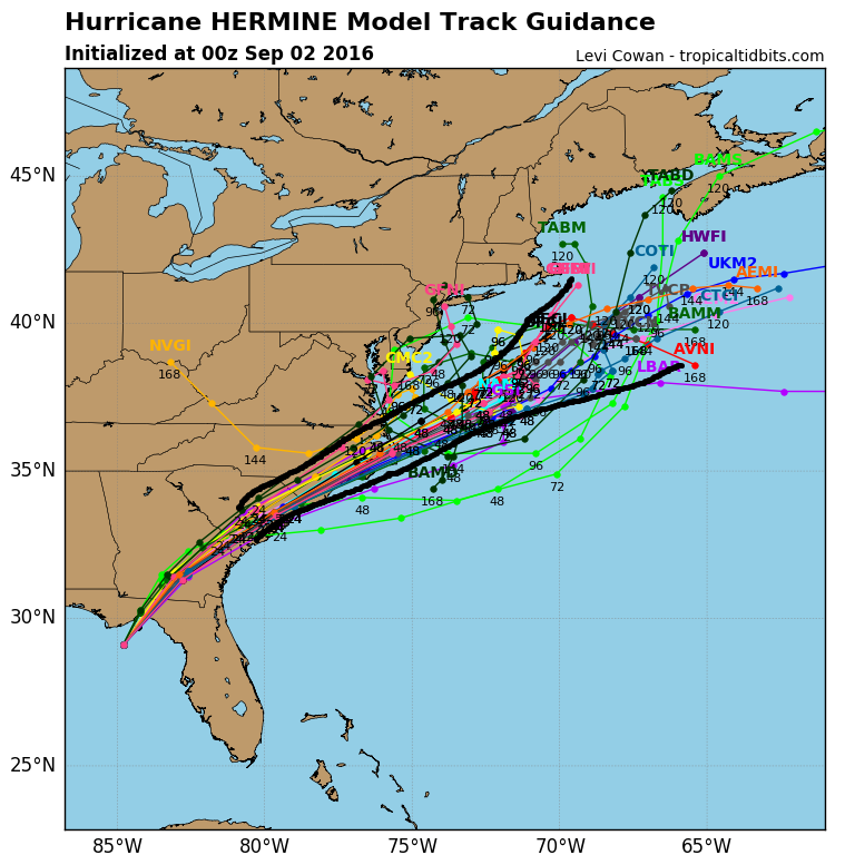
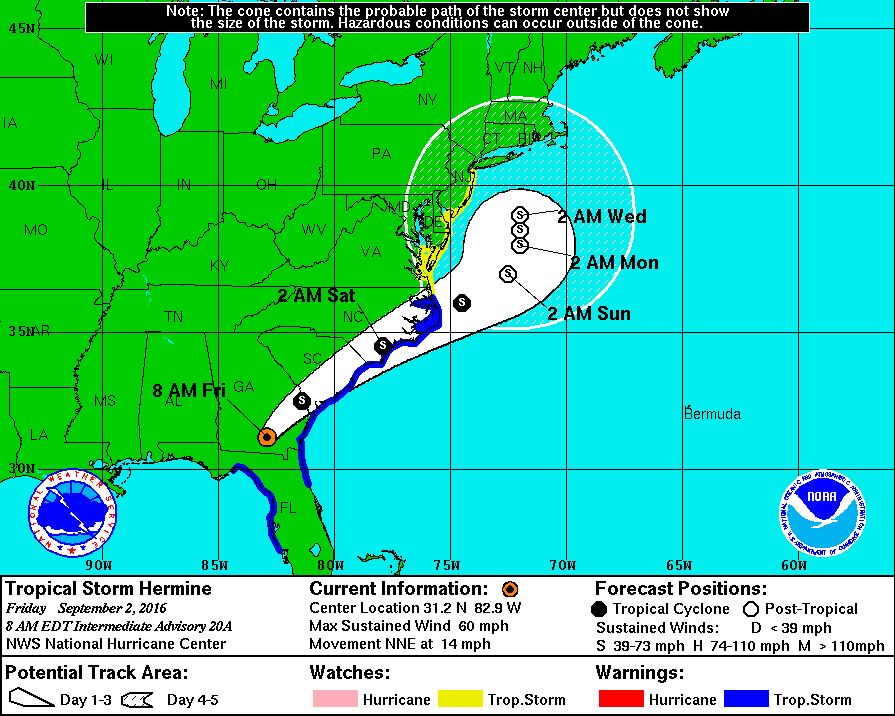
jmanley32 wrote:nhc cone def shifted west and more north than last nights which was ne. now almost due north and a bit west of 11pm.
This is what I'm talking about jman
skinsfan1177- Senior Enthusiast
- Posts : 4485
Join date : 2013-01-07
Re: Hurricane Hermine Discussion
![]() by sroc4 Fri Sep 02, 2016 7:00 am
by sroc4 Fri Sep 02, 2016 7:00 am
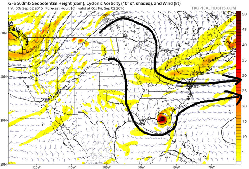
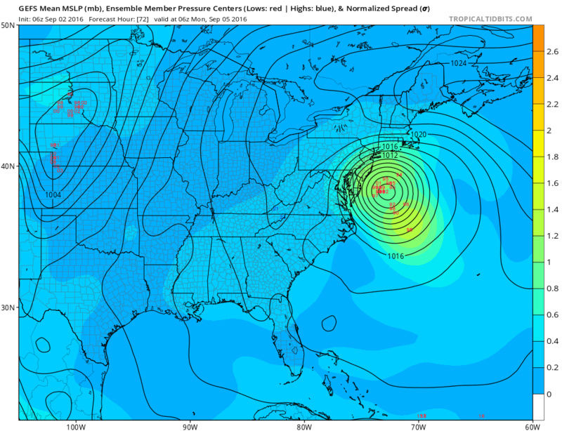
00z:
6Z:

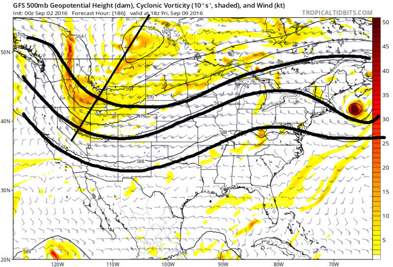
As far as the Loop d loop track it is not unprecendented in the history of tropical cyclones. If you look at 500mb youll understand why that happens assuming the 500mb is currently modeled correctly. Look below. In the first image you'll notice that currently the 500mb trough is pulling the system north as we speak on a track towards the NC/Delmarva coast.
But notice that by hr 42 the system is getting ready to split off the main flow.
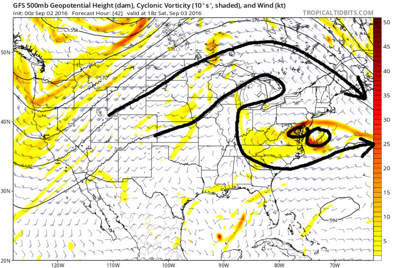
And becomes completely cutoff from the main westerlies. Its at this time you must visualize the system spinning on a flat surface analogous to a top spinning on a flat surface. There is going to be subtle wobbles and it is likely to drift a little but randomly so long as it remains cutoff from the main flow to the north. Take notice of the trough in the western CONUS.

Eventually it heads east and begins to pick the system back up.
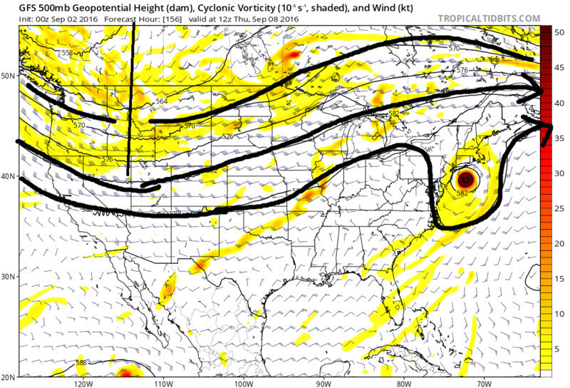
There really is never a true "capture" of this system. IMO we are NOT going to see a track that brings this system back into the coast ala Sandy with a true capture by the trough. Reason being is that there is no longer blocking in the N Atlantic. There is a + NAO which as you can see leads to the main flow becoming very zonal or flat and the approaching trough is positively tilted and not very deep. This leads to a track back to the N or maybe a little NNW but eventually NE once its into the westerly's. The only way this thing makes it back to the coast is if the original track off of NC is tucked in tight along the coast whenit cuts itself off from the main flow.
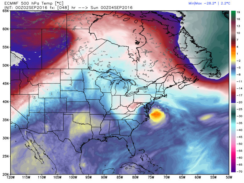
Now it is at this time that the system will begin to undergo its transition from warm core to cold core or hybrib or extratropical...whatever the definition. Take a look at the 500mb temps and notice the cold air wrapping into the system as time moves on. Watch the cold colors come into the back side, SW side, of the system over time.


Now there is a final component of this system that needs to be discussed and may not be know until now cast time. That is the decay of the system. Normally you want to see a tropical system become "vertically stacked" meaning you want the surface center, the 850mb center and the 500mb center to be stacked on top of one another in order to allow air to rise throughout the column. In a purely tropical system this tends to be a positive feedback mechanism allowing it to sustain itself as well as strengthen intesle. However in a non tropical system like say a Nor' easter this tends to signify the beginning of the end of the system. When a non tropical gets vertically stacked, for reasons I don't have the time to explain, the system begins to decay over time. Once this system cuts off, the surface low, 850mb low and 500mb low is forecast, for now, to become vertically stack. The timing of this, the position of the system etc all could influence how expansive the precip filed actually is and who sees the biggest pracip impacts. I'm telling you we are not done tracking this system and people who want the worst case scenario needs to entertain the idea that we still may be BBQing amongst the gusty winds on Sunday with the threat of stray rain bands making it into the area. That said I know that we can have much bigger impacts and that's why I am stressing that we are not don tracking this system.
_________________
"In weather and in life, there's no winning and losing; there's only winning and learning."
WINTER 2012/2013 TOTALS 43.65"WINTER 2017/2018 TOTALS 62.85" WINTER 2022/2023 TOTALS 4.9"
WINTER 2013/2014 TOTALS 64.85"WINTER 2018/2019 TOTALS 14.25" WINTER 2023/2024 TOTALS 13.1"
WINTER 2014/2015 TOTALS 71.20"WINTER 2019/2020 TOTALS 6.35"
WINTER 2015/2016 TOTALS 35.00"WINTER 2020/2021 TOTALS 37.75"
WINTER 2016/2017 TOTALS 42.25"WINTER 2021/2022 TOTALS 31.65"

sroc4- Admin

- Posts : 8331
Reputation : 301
Join date : 2013-01-07
Location : Wading River, LI

skinsfan1177- Senior Enthusiast
- Posts : 4485
Reputation : 35
Join date : 2013-01-07
Age : 46
Location : Point Pleasant Boro
skinsfan1177- Senior Enthusiast
- Posts : 4485
Reputation : 35
Join date : 2013-01-07
Age : 46
Location : Point Pleasant Boro
Re: Hurricane Hermine Discussion
![]() by Frank_Wx Fri Sep 02, 2016 7:23 am
by Frank_Wx Fri Sep 02, 2016 7:23 am
Big 12z runs today
_________________
_______________________________________________________________________________________________________
CLICK HERE to view NJ Strong Snowstorm Classifications

Frank_Wx- Godzilla Seeker
- Posts : 21305
Reputation : 328
Join date : 2013-01-05
Age : 31
Location : Jersey City, NJ -

Re: Hurricane Hermine Discussion
![]() by Guest Fri Sep 02, 2016 7:26 am
by Guest Fri Sep 02, 2016 7:26 am
Guest- Guest
Re: Hurricane Hermine Discussion
![]() by dkodgis Fri Sep 02, 2016 7:29 am
by dkodgis Fri Sep 02, 2016 7:29 am

dkodgis- Senior Enthusiast
- Posts : 2501
Reputation : 98
Join date : 2013-12-29
Re: Hurricane Hermine Discussion
![]() by jmanley32 Fri Sep 02, 2016 7:45 am
by jmanley32 Fri Sep 02, 2016 7:45 am

jmanley32- Senior Enthusiast
- Posts : 20516
Reputation : 108
Join date : 2013-12-12
Age : 42
Location : Yonkers, NY
Re: Hurricane Hermine Discussion
![]() by aiannone Fri Sep 02, 2016 7:47 am
by aiannone Fri Sep 02, 2016 7:47 am
_________________
-Alex Iannone-

aiannone- Senior Enthusiast - Mod

- Posts : 4813
Reputation : 92
Join date : 2013-01-07
Location : Saint James, LI (Northwest Suffolk Co.)
Re: Hurricane Hermine Discussion
![]() by sroc4 Fri Sep 02, 2016 7:53 am
by sroc4 Fri Sep 02, 2016 7:53 am
jmanley32 wrote: Syo o believe sroc explained it's due to the decay as this is not like a noreaster. But yes I too am puzzled.
It's I likely due to the decay via vertical stacking but because it IS like a nor'easter or more appropriately stated NOT true tropical. In a Nor'easter typically the LP center is east of the 500mb center. Ironically when they become vertically stacked typically signifies the strongest point of the storm but if remains vertically stacks leads to the demise or decay of the system. There is a great explanation of this somewhere in my archives. When I find it I'll post it. rb briefly mentioned this decay yesterday I think.
_________________
"In weather and in life, there's no winning and losing; there's only winning and learning."
WINTER 2012/2013 TOTALS 43.65"WINTER 2017/2018 TOTALS 62.85" WINTER 2022/2023 TOTALS 4.9"
WINTER 2013/2014 TOTALS 64.85"WINTER 2018/2019 TOTALS 14.25" WINTER 2023/2024 TOTALS 13.1"
WINTER 2014/2015 TOTALS 71.20"WINTER 2019/2020 TOTALS 6.35"
WINTER 2015/2016 TOTALS 35.00"WINTER 2020/2021 TOTALS 37.75"
WINTER 2016/2017 TOTALS 42.25"WINTER 2021/2022 TOTALS 31.65"
sroc4- Admin
- Posts : 8331
Reputation : 301
Join date : 2013-01-07
Location : Wading River, LI
Re: Hurricane Hermine Discussion
![]() by Quietace Fri Sep 02, 2016 7:57 am
by Quietace Fri Sep 02, 2016 7:57 am
There is a very good probability, especially if the system evolves like the Euro, it transitions back to mostly tropical in nature.sroc4 wrote:jmanley32 wrote: Syo o believe sroc explained it's due to the decay as this is not like a noreaster. But yes I too am puzzled.
It's I likely due to the decay via vertical stacking but because it IS like a nor'easter or more appropriately stated NOT true tropical. In a Nor'easter typically the LP center is east of the 500mb center. Ironically when they become vertically stacked typically signifies the strongest point of the storm but if remains vertically stacks leads to the demise or decay of the system. There is a great explanation of this somewhere in my archives. When I find it I'll post it. rb briefly mentioned this decay yesterday I think.

Quietace- Meteorologist - Mod

- Posts : 3687
Reputation : 33
Join date : 2013-01-07
Age : 27
Location : Point Pleasant, NJ
Re: Hurricane Hermine Discussion
![]() by rb924119 Fri Sep 02, 2016 8:14 am
by rb924119 Fri Sep 02, 2016 8:14 am
rb924119- Meteorologist

- Posts : 6890
Reputation : 194
Join date : 2013-02-06
Age : 32
Location : Greentown, Pa
Re: Hurricane Hermine Discussion
![]() by skinsfan1177 Fri Sep 02, 2016 8:17 am
by skinsfan1177 Fri Sep 02, 2016 8:17 am
skinsfan1177- Senior Enthusiast
- Posts : 4485
Reputation : 35
Join date : 2013-01-07
Age : 46
Location : Point Pleasant Boro
Re: Hurricane Hermine Discussion
![]() by amugs Fri Sep 02, 2016 8:31 am
by amugs Fri Sep 02, 2016 8:31 am
_________________
Mugs
AKA:King: Snow Weenie
Self Proclaimed
WINTER 2014-15 : 55.12" +.02 for 6 coatings (avg. 35")
WINTER 2015-16 Total - 29.8" (Avg 35")
WINTER 2016-17 : 39.5" so far

amugs- Advanced Forecaster - Mod
- Posts : 15093
Reputation : 213
Join date : 2013-01-07
Age : 54
Location : Hillsdale,NJ
Re: Hurricane Hermine Discussion
![]() by sroc4 Fri Sep 02, 2016 8:34 am
by sroc4 Fri Sep 02, 2016 8:34 am
_________________
"In weather and in life, there's no winning and losing; there's only winning and learning."
WINTER 2012/2013 TOTALS 43.65"WINTER 2017/2018 TOTALS 62.85" WINTER 2022/2023 TOTALS 4.9"
WINTER 2013/2014 TOTALS 64.85"WINTER 2018/2019 TOTALS 14.25" WINTER 2023/2024 TOTALS 13.1"
WINTER 2014/2015 TOTALS 71.20"WINTER 2019/2020 TOTALS 6.35"
WINTER 2015/2016 TOTALS 35.00"WINTER 2020/2021 TOTALS 37.75"
WINTER 2016/2017 TOTALS 42.25"WINTER 2021/2022 TOTALS 31.65"
sroc4- Admin
- Posts : 8331
Reputation : 301
Join date : 2013-01-07
Location : Wading River, LI
Re: Hurricane Hermine Discussion
![]() by jmanley32 Fri Sep 02, 2016 8:38 am
by jmanley32 Fri Sep 02, 2016 8:38 am
Last edited by jmanley32 on Fri Sep 02, 2016 9:47 am; edited 1 time in total
jmanley32- Senior Enthusiast
- Posts : 20516
Reputation : 108
Join date : 2013-12-12
Age : 42
Location : Yonkers, NY
Re: Hurricane Hermine Discussion
![]() by sabamfa Fri Sep 02, 2016 8:41 am
by sabamfa Fri Sep 02, 2016 8:41 am
sabamfa- Pro Enthusiast

- Posts : 246
Reputation : 2
Join date : 2013-11-05
Age : 37
Location : Wayne, NJ
Re: Hurricane Hermine Discussion
![]() by sroc4 Fri Sep 02, 2016 8:42 am
by sroc4 Fri Sep 02, 2016 8:42 am
jmanley32 wrote:Ace seems to think nyc area could get added to ts watches which would signify to me a more nw movement.
I won't speak for him but LI and N coast of NJ will be in the watch area once the timing is closer. It's like looking at a winter storm watch. It's all about timing. There is no doubt tropical storm force winds sustained and or gusts are likely along the entire coast.
_________________
"In weather and in life, there's no winning and losing; there's only winning and learning."
WINTER 2012/2013 TOTALS 43.65"WINTER 2017/2018 TOTALS 62.85" WINTER 2022/2023 TOTALS 4.9"
WINTER 2013/2014 TOTALS 64.85"WINTER 2018/2019 TOTALS 14.25" WINTER 2023/2024 TOTALS 13.1"
WINTER 2014/2015 TOTALS 71.20"WINTER 2019/2020 TOTALS 6.35"
WINTER 2015/2016 TOTALS 35.00"WINTER 2020/2021 TOTALS 37.75"
WINTER 2016/2017 TOTALS 42.25"WINTER 2021/2022 TOTALS 31.65"
sroc4- Admin
- Posts : 8331
Reputation : 301
Join date : 2013-01-07
Location : Wading River, LI
Re: Hurricane Hermine Discussion
![]() by Dtone Fri Sep 02, 2016 8:45 am
by Dtone Fri Sep 02, 2016 8:45 am
skinsfan1177 wrote:I do know the water is like a bathtub up here
That helps but is its effects being overstated some?
Even if water temps are like southeast water temps its still not the same. Even 80 at this latitude while impressive, isnt the same as same temp in the south. That warm water is shallow here, churn the water up enough and it could turn to 68.
Dtone- Wx Statistician Guru

- Posts : 1738
Reputation : 9
Join date : 2013-08-26
Location : Bronx, NY
Re: Hurricane Hermine Discussion
![]() by skinsfan1177 Fri Sep 02, 2016 8:57 am
by skinsfan1177 Fri Sep 02, 2016 8:57 am
Dtone wrote:skinsfan1177 wrote:I do know the water is like a bathtub up here
That helps but is its effects being overstated some?
Even if water temps are like southeast water temps its still not the same. Even 80 at this latitude while impressive, isnt the same as same temp in the south. That warm water is shallow here, churn the water up enough and it could turn to 68.
I don't believe so the waters here are warmer than usual and that jet stream will fuel this monster
skinsfan1177- Senior Enthusiast
- Posts : 4485
Reputation : 35
Join date : 2013-01-07
Age : 46
Location : Point Pleasant Boro
Re: Hurricane Hermine Discussion
![]() by NjWeatherGuy Fri Sep 02, 2016 8:59 am
by NjWeatherGuy Fri Sep 02, 2016 8:59 am
amugs wrote:TICKING WEST - FRANK SAID IT WOULD GET PULLED WEST SO LOOK AT THIS NOW - UMMMM...
Yeah but note north movement, likely wont make it any farther, it will get kicked east where it stalls, so if its well to the SE, aside from some coastal flooding, not a big deal. Storm center, tightest isobars and wind will mostly be over water per latest guidance.

NjWeatherGuy- Advanced Forecaster

- Posts : 4100
Reputation : 28
Join date : 2013-01-06
Location : Belle Mead, NJ
Re: Hurricane Hermine Discussion
![]() by amugs Fri Sep 02, 2016 9:04 am
by amugs Fri Sep 02, 2016 9:04 am
sroc4 wrote:It really hasn't Mugs. The Cone of uncertainty expanded. Track still has it S and East of the BM by Wed.
True but the position of L in this cone is starting to show a westward curve to it. Albeit not a lot and I am not hyping but just stating that we are starting to see that that it retrogres off the Delmarva and not going ene but also stalls in tjis area. Just my interpretation. NJ coastline down to OC MD shores are the prime zone. Beach erosion will be bad imho due to the hours of water piling up on the shore line, a few high tides in duration with a new moon.
Big 12z suite today but not the final.
_________________
Mugs
AKA:King: Snow Weenie
Self Proclaimed
WINTER 2014-15 : 55.12" +.02 for 6 coatings (avg. 35")
WINTER 2015-16 Total - 29.8" (Avg 35")
WINTER 2016-17 : 39.5" so far
amugs- Advanced Forecaster - Mod
- Posts : 15093
Reputation : 213
Join date : 2013-01-07
Age : 54
Location : Hillsdale,NJ
Re: Hurricane Hermine Discussion
![]() by sroc4 Fri Sep 02, 2016 9:19 am
by sroc4 Fri Sep 02, 2016 9:19 am
amugs wrote:sroc4 wrote:It really hasn't Mugs. The Cone of uncertainty expanded. Track still has it S and East of the BM by Wed.
True but the position of L in this cone is starting to show a westward curve to it. Albeit not a lot and I am not hyping but just stating that we are starting to see that that it retrogres off the Delmarva and not going ene but also stalls in tjis area. Just my interpretation. NJ coastline down to OC MD shores are the prime zone. Beach erosion will be bad imho due to the hours of water piling up on the shore line, a few high tides in duration with a new moon.
Big 12z suite today but not the final.
I hear ya brother. And I'm not trying to be a debby downer in the other direction either. Next 24hrs will be interesting.
_________________
"In weather and in life, there's no winning and losing; there's only winning and learning."
WINTER 2012/2013 TOTALS 43.65"WINTER 2017/2018 TOTALS 62.85" WINTER 2022/2023 TOTALS 4.9"
WINTER 2013/2014 TOTALS 64.85"WINTER 2018/2019 TOTALS 14.25" WINTER 2023/2024 TOTALS 13.1"
WINTER 2014/2015 TOTALS 71.20"WINTER 2019/2020 TOTALS 6.35"
WINTER 2015/2016 TOTALS 35.00"WINTER 2020/2021 TOTALS 37.75"
WINTER 2016/2017 TOTALS 42.25"WINTER 2021/2022 TOTALS 31.65"
sroc4- Admin
- Posts : 8331
Reputation : 301
Join date : 2013-01-07
Location : Wading River, LI
Re: Hurricane Hermine Discussion
![]() by Snow88 Fri Sep 02, 2016 9:23 am
by Snow88 Fri Sep 02, 2016 9:23 am
NjWeatherGuy wrote:amugs wrote:TICKING WEST - FRANK SAID IT WOULD GET PULLED WEST SO LOOK AT THIS NOW - UMMMM...
Yeah but note north movement, likely wont make it any farther, it will get kicked east where it stalls, so if its well to the SE, aside from some coastal flooding, not a big deal. Storm center, tightest isobars and wind will mostly be over water per latest guidance.
It will not get kicked east until the trough comes back next week. The latest hurricane models have it recurving now. GFS and Nam shifted west . Lets see if the west shit is real.

Snow88- Senior Enthusiast
- Posts : 2193
Reputation : 4
Join date : 2013-01-09
Age : 35
Location : Brooklyn, NY
skinsfan1177- Senior Enthusiast
- Posts : 4485
Reputation : 35
Join date : 2013-01-07
Age : 46
Location : Point Pleasant Boro
Page 29 of 40 • 1 ... 16 ... 28, 29, 30 ... 34 ... 40 ![]()
|
|
|