
 Search
Long Range Thread 12.0
Page 26 of 40 •  1 ... 14 ... 25, 26, 27 ... 33 ... 40
 ![]()
Re: Long Range Thread 12.0
![]() by sroc4 Mon Nov 28, 2016 12:03 pm
by sroc4 Mon Nov 28, 2016 12:03 pm
amugs wrote:syosnow94 wrote:Cutters in early December don't excite me. Sorry!
I hear ya BUT what we need understand is that cutter can be and a re prelude at times (many actually) to a changing pattern and help start to set thing sup as we move forward - ala 50/50 block, blanket a cold pol of air source in Canada, help break teh dam of cut off Arctic air etc. So I will take a cutter or two to help do this which I think start to occur.
Jim, I want a snowstorm as bad as the next weenie on this board but understand which I know yuo do that we things to take shape and cutters help this occur.
Agree!!!
sroc4- Admin

- Posts : 8331
Join date : 2013-01-07
Re: Long Range Thread 12.0
![]() by Snow88 Mon Nov 28, 2016 1:43 pm
by Snow88 Mon Nov 28, 2016 1:43 pm
Snow88- Senior Enthusiast

- Posts : 2193
Join date : 2013-01-09
Re: Long Range Thread 12.0
![]() by algae888 Mon Nov 28, 2016 1:48 pm
by algae888 Mon Nov 28, 2016 1:48 pm
Yes snow euro holds its ground. So different from gfs and cmc. Ukie out 6 days looks like euro however. I like the block to our north. Looks like at hr 168 wants to redevelope off the south jersey coast. would love to hear Frank and Scott's thoughtsSnow88 wrote:Euro is coming in colder/ less amped for the 5th storm. Great hit for interior areas.

algae888- Advanced Forecaster

- Posts : 5311
Reputation : 46
Join date : 2013-02-05
Age : 61
Location : mt. vernon, new york
Re: Long Range Thread 12.0
![]() by algae888 Mon Nov 28, 2016 1:52 pm
by algae888 Mon Nov 28, 2016 1:52 pm
algae888- Advanced Forecaster
- Posts : 5311
Reputation : 46
Join date : 2013-02-05
Age : 61
Location : mt. vernon, new york
Re: Long Range Thread 12.0
![]() by Snow88 Mon Nov 28, 2016 1:57 pm
by Snow88 Mon Nov 28, 2016 1:57 pm
algae888 wrote:Yes snow euro holds its ground. So different from gfs and cmc. Ukie out 6 days looks like euro however. I like the block to our north. Looks like at hr 168 wants to redevelope off the south jersey coast. would love to hear Frank and Scott's thoughtsSnow88 wrote:Euro is coming in colder/ less amped for the 5th storm. Great hit for interior areas.
I wonder if it can trend even more colder
GEFS doesn't want any part of the big storm

Snow88- Senior Enthusiast
- Posts : 2193
Reputation : 4
Join date : 2013-01-09
Age : 35
Location : Brooklyn, NY
Re: Long Range Thread 12.0
![]() by algae888 Mon Nov 28, 2016 2:01 pm
by algae888 Mon Nov 28, 2016 2:01 pm
Big difference in the models. If you take a compromise then that can be good for us even down to coast. Snow did euro have any front end snow for nyc metro?Snow88 wrote:algae888 wrote:Yes snow euro holds its ground. So different from gfs and cmc. Ukie out 6 days looks like euro however. I like the block to our north. Looks like at hr 168 wants to redevelope off the south jersey coast. would love to hear Frank and Scott's thoughtsSnow88 wrote:Euro is coming in colder/ less amped for the 5th storm. Great hit for interior areas.
I wonder if it can trend even more colder
GEFS doesn't want any part of the big storm
algae888- Advanced Forecaster
- Posts : 5311
Reputation : 46
Join date : 2013-02-05
Age : 61
Location : mt. vernon, new york
Re: Long Range Thread 12.0
![]() by algae888 Mon Nov 28, 2016 2:03 pm
by algae888 Mon Nov 28, 2016 2:03 pm
algae888- Advanced Forecaster
- Posts : 5311
Reputation : 46
Join date : 2013-02-05
Age : 61
Location : mt. vernon, new york
Re: Long Range Thread 12.0
![]() by Snow88 Mon Nov 28, 2016 2:14 pm
by Snow88 Mon Nov 28, 2016 2:14 pm
algae888 wrote:Big difference in the models. If you take a compromise then that can be good for us even down to coast. Snow did euro have any front end snow for nyc metro?Snow88 wrote:algae888 wrote:Yes snow euro holds its ground. So different from gfs and cmc. Ukie out 6 days looks like euro however. I like the block to our north. Looks like at hr 168 wants to redevelope off the south jersey coast. would love to hear Frank and Scott's thoughtsSnow88 wrote:Euro is coming in colder/ less amped for the 5th storm. Great hit for interior areas.
I wonder if it can trend even more colder
GEFS doesn't want any part of the big storm
Not really
Snow88- Senior Enthusiast
- Posts : 2193
Reputation : 4
Join date : 2013-01-09
Age : 35
Location : Brooklyn, NY
Re: Long Range Thread 12.0
![]() by sroc4 Mon Nov 28, 2016 2:19 pm
by sroc4 Mon Nov 28, 2016 2:19 pm
algae888 wrote:Yes snow euro holds its ground. So different from gfs and cmc. Ukie out 6 days looks like euro however. I like the block to our north. Looks like at hr 168 wants to redevelope off the south jersey coast. would love to hear Frank and Scott's thoughtsSnow88 wrote:Euro is coming in colder/ less amped for the 5th storm. Great hit for interior areas.
Cant do a detailed analysis with maps but positive trends for sure. I notice a few things on the euro. First the HP to the north holds on a bot longer before the primary erodes its eastern flank forcing the primary further east on 12z compared to 00z. second, Ironically, if you look at the 500mb maps from 00z to 12z there is less ridging in the west on 12z compared to 00z. This actually would help our cause I believe. The stronger ridging leads to an earlier phase and the ULL closes off 6 hrs earlier on 00z when compared to 12z causing it to cut N earlier which we dont want. We want it to drift east and weaker and then secondary on or off the coast(ideally) before it reaches our lat.
We need a couple of things in order for this to work out for most of us, although I could def see surprise totals in the same places that saw it last time. There is a weak NAO block in place. If this can trend a little bit further west into greenland and the HP to the N holds strong, and there isnt too much phasing too early over the southern plains then we could have a decent overrunning event on our hands. If the ridging isnt too strong to the west and the NAO block is further west it would likely lead to a stronger HP to the N and slow things down such that we may form a secondary earlier.
Right now temp profiles dont look great esp at 925mb relative to the timing, but with 5-7days to go this means nothing at this point. Lessons learned in the past with potential over running events and cold air damning CAD, which the cold air should be in place ahead of the systems arrival, models almost always underestimate the staying power of the cold.
Anyway I have not looked at any of the other models in any detail to see how the 500mb maps compare to the euro for the same time period, so for now I will stay cautious, but one eyebrow is up and head is cocked sideways with a subtle grunt noise from my mouth.
_________________
"In weather and in life, there's no winning and losing; there's only winning and learning."
WINTER 2012/2013 TOTALS 43.65"WINTER 2017/2018 TOTALS 62.85" WINTER 2022/2023 TOTALS 4.9"
WINTER 2013/2014 TOTALS 64.85"WINTER 2018/2019 TOTALS 14.25" WINTER 2023/2024 TOTALS 13.1"
WINTER 2014/2015 TOTALS 71.20"WINTER 2019/2020 TOTALS 6.35"
WINTER 2015/2016 TOTALS 35.00"WINTER 2020/2021 TOTALS 37.75"
WINTER 2016/2017 TOTALS 42.25"WINTER 2021/2022 TOTALS 31.65"

sroc4- Admin
- Posts : 8331
Reputation : 301
Join date : 2013-01-07
Location : Wading River, LI
Re: Long Range Thread 12.0
![]() by amugs Mon Nov 28, 2016 3:03 pm
by amugs Mon Nov 28, 2016 3:03 pm
_________________
Mugs
AKA:King: Snow Weenie
Self Proclaimed
WINTER 2014-15 : 55.12" +.02 for 6 coatings (avg. 35")
WINTER 2015-16 Total - 29.8" (Avg 35")
WINTER 2016-17 : 39.5" so far

amugs- Advanced Forecaster - Mod

- Posts : 15093
Reputation : 213
Join date : 2013-01-07
Age : 54
Location : Hillsdale,NJ
Re: Long Range Thread 12.0
![]() by nutleyblizzard Mon Nov 28, 2016 3:18 pm
by nutleyblizzard Mon Nov 28, 2016 3:18 pm
Yes it is impressive, but is it the beginning of a colder regime or just a transient shot? That's the big question.amugs wrote:Look at this cold air WOW!!

nutleyblizzard- Senior Enthusiast
- Posts : 1952
Reputation : 41
Join date : 2014-01-30
Age : 58
Location : Nutley, new jersey
Re: Long Range Thread 12.0
![]() by algae888 Mon Nov 28, 2016 4:15 pm
by algae888 Mon Nov 28, 2016 4:15 pm
I think relax and reload that's the pattern for this winter and very active. It's going to be hard to keep the cold locked in for extended periods of time in this warmer climate .Should be a lot of fun although not every system will be frozen. Hearing a monster negative EPO Ridge on the day 11 to 15 euro ensembles.nutleyblizzard wrote:Yes it is impressive, but is it the beginning of a colder regime or just a transient shot? That's the big question.amugs wrote:Look at this cold air WOW!!
algae888- Advanced Forecaster
- Posts : 5311
Reputation : 46
Join date : 2013-02-05
Age : 61
Location : mt. vernon, new york
Re: Long Range Thread 12.0
![]() by algae888 Mon Nov 28, 2016 4:27 pm
by algae888 Mon Nov 28, 2016 4:27 pm
algae888- Advanced Forecaster
- Posts : 5311
Reputation : 46
Join date : 2013-02-05
Age : 61
Location : mt. vernon, new york
Re: Long Range Thread 12.0
![]() by Frank_Wx Mon Nov 28, 2016 4:45 pm
by Frank_Wx Mon Nov 28, 2016 4:45 pm

_________________
_______________________________________________________________________________________________________
CLICK HERE to view NJ Strong Snowstorm Classifications

Frank_Wx- Godzilla Seeker
- Posts : 21305
Reputation : 328
Join date : 2013-01-05
Age : 31
Location : Jersey City, NJ -

Re: Long Range Thread 12.0
![]() by amugs Mon Nov 28, 2016 4:49 pm
by amugs Mon Nov 28, 2016 4:49 pm
Build it and it will SNOWWW!
_________________
Mugs
AKA:King: Snow Weenie
Self Proclaimed
WINTER 2014-15 : 55.12" +.02 for 6 coatings (avg. 35")
WINTER 2015-16 Total - 29.8" (Avg 35")
WINTER 2016-17 : 39.5" so far
amugs- Advanced Forecaster - Mod
- Posts : 15093
Reputation : 213
Join date : 2013-01-07
Age : 54
Location : Hillsdale,NJ
Re: Long Range Thread 12.0
![]() by algae888 Mon Nov 28, 2016 6:44 pm
by algae888 Mon Nov 28, 2016 6:44 pm
algae888- Advanced Forecaster
- Posts : 5311
Reputation : 46
Join date : 2013-02-05
Age : 61
Location : mt. vernon, new york
Re: Long Range Thread 12.0
![]() by algae888 Mon Nov 28, 2016 6:59 pm
by algae888 Mon Nov 28, 2016 6:59 pm
"The stratospheric PV is predicted to begin winter near record weak, polar opposite to last winter when it was near record strong to start winter. In contrast to last winter when maritime flow crossed the continents unimpeded, this winter PV circulation shows little to none maritime flow across the continents."
North America where record low snow cover and warm temperatures highlighted November is predicted to experience a dramatic reversal. Strong ridging/positive geopotential height anomalies centered over the Aleutian’s, will allow cold air to pool in Alaska and Western Canada for the first half of December. More expansive cold air should also favor a more rapid expansion of snow cover across the continent."
"Now for what I consider the most important uncertainties related to the winter forecast. First I do believe there can be too much of a good thing. Typically the significant weakening of the PV related to the rapid advance of snow cover occurs in mid-winter with a peak frequency in January. This maximizes the impact of the atmospheric response to snow cover variability on winter means. However with the rapid advance in Eurasian snow cover and strong and accelerated atmospheric response, the PV weakening began even before winter started and will peak the first week of December. Therefore the full impact of the extensive October snow cover will likely be complete with most of the winter still ahead. Therefore the success of the forecast will likely depend on at least one further weakening of the PV later this winter. Our research (Furtadoetal_GRL16.pdf) has shown that snow cover favors an earlier and sea ice a later winter weakening of the PV. Therefore I do believe that the low sea ice in the Barents-Kara seas favors a subsequent SSW/weak PV later this winter. An analog for this scenario would be the winter of 2009/10. "
here is link if anyone wants to read...
http://www.aer.com/science-research/climate-weather/arctic-oscillation
algae888- Advanced Forecaster
- Posts : 5311
Reputation : 46
Join date : 2013-02-05
Age : 61
Location : mt. vernon, new york
Re: Long Range Thread 12.0
![]() by algae888 Mon Nov 28, 2016 7:06 pm
by algae888 Mon Nov 28, 2016 7:06 pm

Siberia thru Alaska , Canada into northern tier of U.S.
algae888- Advanced Forecaster
- Posts : 5311
Reputation : 46
Join date : 2013-02-05
Age : 61
Location : mt. vernon, new york
Re: Long Range Thread 12.0
![]() by amugs Mon Nov 28, 2016 7:27 pm
by amugs Mon Nov 28, 2016 7:27 pm
Control
.png)
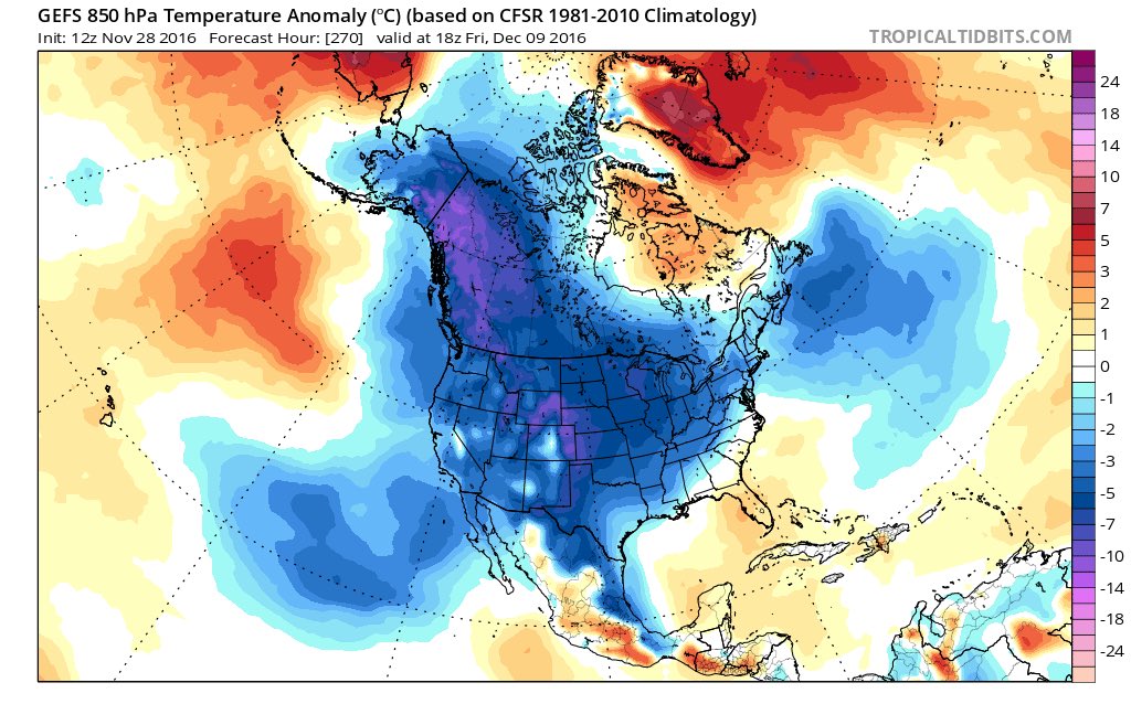
MEAN - HOLY MOTHER OF COLD!!!!
BATHTUB SLOSH EFFECT IN FULL FORCE PEEPS!! COLDEST XMASS SINCE 1980 INCOMING I AM CALLING IT!!!
.png)
_________________
Mugs
AKA:King: Snow Weenie
Self Proclaimed
WINTER 2014-15 : 55.12" +.02 for 6 coatings (avg. 35")
WINTER 2015-16 Total - 29.8" (Avg 35")
WINTER 2016-17 : 39.5" so far
amugs- Advanced Forecaster - Mod
- Posts : 15093
Reputation : 213
Join date : 2013-01-07
Age : 54
Location : Hillsdale,NJ
Re: Long Range Thread 12.0
![]() by amugs Mon Nov 28, 2016 7:31 pm
by amugs Mon Nov 28, 2016 7:31 pm
EPS MEAN for WHITE GOLD - I'LL TAKE IT!!!
.png)
_________________
Mugs
AKA:King: Snow Weenie
Self Proclaimed
WINTER 2014-15 : 55.12" +.02 for 6 coatings (avg. 35")
WINTER 2015-16 Total - 29.8" (Avg 35")
WINTER 2016-17 : 39.5" so far
amugs- Advanced Forecaster - Mod
- Posts : 15093
Reputation : 213
Join date : 2013-01-07
Age : 54
Location : Hillsdale,NJ
Re: Long Range Thread 12.0
![]() by Frank_Wx Mon Nov 28, 2016 8:28 pm
by Frank_Wx Mon Nov 28, 2016 8:28 pm
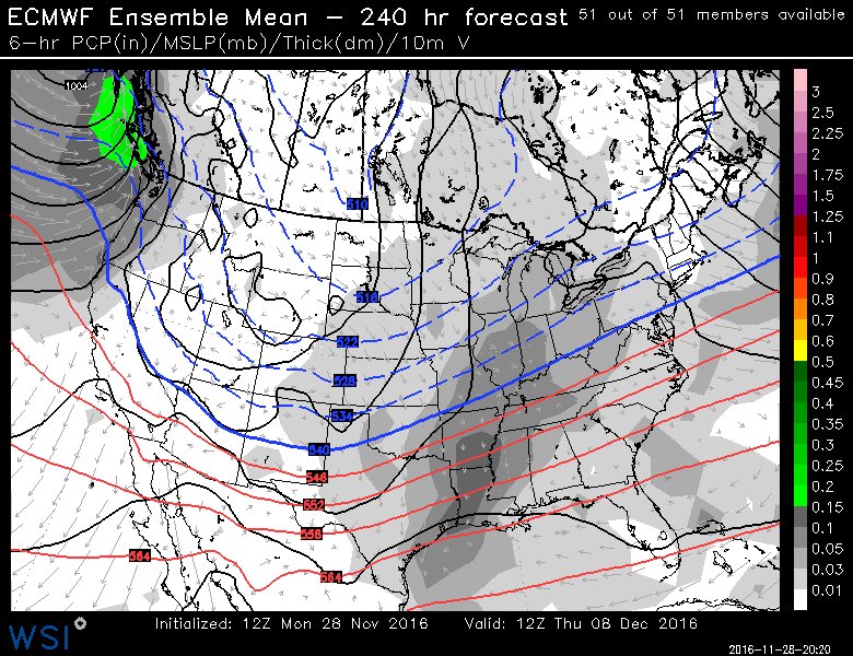
Day 7-14

Day 11-18

_________________
_______________________________________________________________________________________________________
CLICK HERE to view NJ Strong Snowstorm Classifications
Frank_Wx- Godzilla Seeker
- Posts : 21305
Reputation : 328
Join date : 2013-01-05
Age : 31
Location : Jersey City, NJ -
Re: Long Range Thread 12.0
![]() by Frank_Wx Mon Nov 28, 2016 9:09 pm
by Frank_Wx Mon Nov 28, 2016 9:09 pm


The WPO is going to achieve a negative intensity similar to where the EPO was a couple of years ago. It will be expansive enough to turn the EPO negative for a period of time as well. In conjunction these signals will be responsible for putting the northern tier of the CONUS in a colder than normal temp regime as a cross-polar flow ushers into our region.

A global view of the EPS show how poleward those positive heights from the WPO extend into the western Arctic. As mentioned, those anomalous heights will send an arctic blast into the central and eastern CONUS.
Meanwhile, a north Atlantic block is trying to develop on latest guidance. It looks like the deep trough in the NW Atlantic helps build a ridge over northwestern Europe. This should help lock the cold air mass the -WPO/-EPO provides us. If the modeled -WPO/-EPO comes to fruition, and there is a semblance of blocking, then I feel comfortable saying the period between the 7th and 14th will be our first decent opportunity to see a widespread snow event. It's certainly not a 'madonne' look in my mind - at least not yet - but for December purposes this will be a good pattern I hope we can take advantage of. Granted it's still a little early, so we'll see how models look by the weekend. A slight weakening in the WPO ridge could allow the baroclinic zone to stay to our west-northwest, so hopefully models are correct with its current intensity.
_________________
_______________________________________________________________________________________________________
CLICK HERE to view NJ Strong Snowstorm Classifications
Frank_Wx- Godzilla Seeker
- Posts : 21305
Reputation : 328
Join date : 2013-01-05
Age : 31
Location : Jersey City, NJ -
Re: Long Range Thread 12.0
![]() by amugs Mon Nov 28, 2016 9:41 pm
by amugs Mon Nov 28, 2016 9:41 pm
WPO is the main driver here and like I said in earlier posts the N WPO will buckle the flow and block up that firehose of the PAC JET we have had and then take the - PNA and turn it positive.
Build those heights over the top and what goes up must come down right?
Bathtub Slosh effect FTW !!
_________________
Mugs
AKA:King: Snow Weenie
Self Proclaimed
WINTER 2014-15 : 55.12" +.02 for 6 coatings (avg. 35")
WINTER 2015-16 Total - 29.8" (Avg 35")
WINTER 2016-17 : 39.5" so far
amugs- Advanced Forecaster - Mod
- Posts : 15093
Reputation : 213
Join date : 2013-01-07
Age : 54
Location : Hillsdale,NJ
Re: Long Range Thread 12.0
![]() by amugs Mon Nov 28, 2016 10:05 pm
by amugs Mon Nov 28, 2016 10:05 pm

_________________
Mugs
AKA:King: Snow Weenie
Self Proclaimed
WINTER 2014-15 : 55.12" +.02 for 6 coatings (avg. 35")
WINTER 2015-16 Total - 29.8" (Avg 35")
WINTER 2016-17 : 39.5" so far
amugs- Advanced Forecaster - Mod
- Posts : 15093
Reputation : 213
Join date : 2013-01-07
Age : 54
Location : Hillsdale,NJ
Re: Long Range Thread 12.0
![]() by sroc4 Tue Nov 29, 2016 7:41 am
by sroc4 Tue Nov 29, 2016 7:41 am
_________________
"In weather and in life, there's no winning and losing; there's only winning and learning."
WINTER 2012/2013 TOTALS 43.65"WINTER 2017/2018 TOTALS 62.85" WINTER 2022/2023 TOTALS 4.9"
WINTER 2013/2014 TOTALS 64.85"WINTER 2018/2019 TOTALS 14.25" WINTER 2023/2024 TOTALS 13.1"
WINTER 2014/2015 TOTALS 71.20"WINTER 2019/2020 TOTALS 6.35"
WINTER 2015/2016 TOTALS 35.00"WINTER 2020/2021 TOTALS 37.75"
WINTER 2016/2017 TOTALS 42.25"WINTER 2021/2022 TOTALS 31.65"
sroc4- Admin
- Posts : 8331
Reputation : 301
Join date : 2013-01-07
Location : Wading River, LI
Re: Long Range Thread 12.0
![]() by rb924119 Tue Nov 29, 2016 8:12 am
by rb924119 Tue Nov 29, 2016 8:12 am
That said, come mid-December, if this north-central Pacific ridging develops as it's progged to, that's going to skyrocket wave-1 flux into the Stratosphere. Combine the lull that we have seen with the ridging in this area for the last week or two in this area with the continued wave-1 fluxes making their way up from the NAO region, this could allow the PV to pivot cyclonically around the pole, as the NAO fluxes also begin to pivot, enough to get on our side then become displaced southward toward Hudson Bay once the fluxes from the north-central Pacific start having their impacts. It may be brief, since we lose the Atlantic fluxes just as those from the Pacific start kicking in, but there should be a little overlap that bodes well for at least a short period of significant cold. Then it looks like the Atlantic tries to start again with the fluxes, although this time around the opposite side still looks to be relatively favorable, which could lead to a longer duration displacement of the PV, possibly on our side of the globe, heading into the start of the new year. This is all eye candy at this point, though, since as Scott said, we have to see if the Pacific side of things actually plays out like it's progged to. Based on what we saw with the last event, however, I feel that the Pacific is not the side to worry about, since that has already proven to be "easily" perturbed by severe ridging; it's the Atlantic, which has already failed us this season, by not being as blocky as modeled in the longer range.
rb924119- Meteorologist

- Posts : 6890
Reputation : 194
Join date : 2013-02-06
Age : 32
Location : Greentown, Pa
Re: Long Range Thread 12.0
![]() by Frank_Wx Tue Nov 29, 2016 9:06 am
by Frank_Wx Tue Nov 29, 2016 9:06 am
sroc4 wrote:There is no doubt there are positive signs on the horizon, but IMHO it would be unwise to buy into the hype depicted in modeling lock stop and barrel. Looks good from far, but up close, far from good could be at play. Alot is riding on the -WPO ridging that has yet to establish itself, and the NAO region will be an important key as well, so until we see how this sets up the future of snow and cold chances are still uncertain. Cold is the first ingredient needed if we want snow, and at the very least that looks to be coming to some degree in the east, but the timing of the cold and where the energy comes together will play a huge role in the outcome of many of the precipitation events liquid vs frozen. Again some very encouraging signs on the horizon, the results of which could end up being fantastic, but I would not go all in just yet because there are other large scale features that could temper the outcome of a strong pole ward block like a -WPO or -EPO esp because we are still early in the season. That is all.
Agree, we're already seeing models back off on the intensity of the -WPO ridge. Heights are less potent in the Arctic region this morning, allowing the SE ridge to overpower the northern jet. The only way the 2nd week of December works out is if the -WPO reaches record levels. Bad trend overnight, IMO.
_________________
_______________________________________________________________________________________________________
CLICK HERE to view NJ Strong Snowstorm Classifications
Frank_Wx- Godzilla Seeker
- Posts : 21305
Reputation : 328
Join date : 2013-01-05
Age : 31
Location : Jersey City, NJ -
Page 26 of 40 • 1 ... 14 ... 25, 26, 27 ... 33 ... 40 ![]()
|
|
|