
 Search
Long Range Thread 12.0
Page 35 of 40 •  1 ... 19 ... 34, 35, 36 ... 40
 ![]()
Re: Long Range Thread 12.0
![]() by amugs Fri Dec 09, 2016 3:23 pm
by amugs Fri Dec 09, 2016 3:23 pm
amugs- Advanced Forecaster - Mod

- Posts : 15093
Join date : 2013-01-07
Re: Long Range Thread 12.0
![]() by amugs Fri Dec 09, 2016 3:28 pm
by amugs Fri Dec 09, 2016 3:28 pm
algae888 wrote:Yes i know we will not end up close to feb 2015. However I think -3 looks pretty good at the moment and maybe -5 if the EPO can deliver. There really isn't a month to compare this December to over the last several years if guidance is correct. just look at today's Euro, we're looking at negative 20 to 25 temperature departures the end of next week
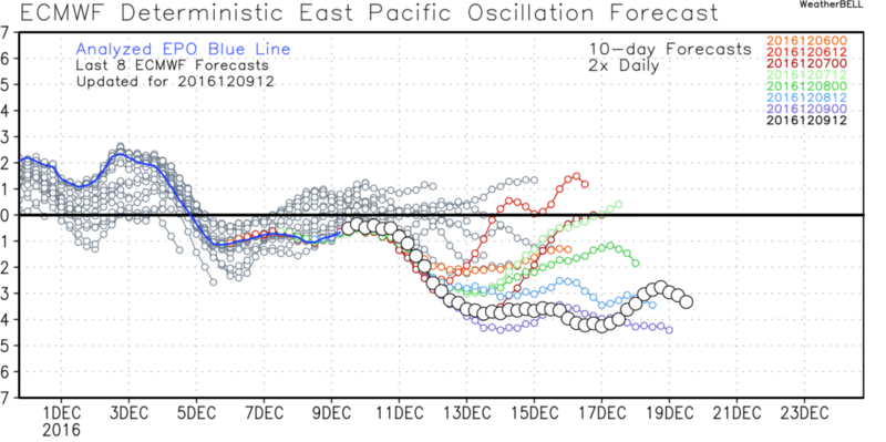
Al is it me or we keep getting colder? The EPO went from slight N middle of teh week to now -3 SD
amugs- Advanced Forecaster - Mod
- Posts : 15093
Join date : 2013-01-07
Re: Long Range Thread 12.0
![]() by nutleyblizzard Fri Dec 09, 2016 3:46 pm
by nutleyblizzard Fri Dec 09, 2016 3:46 pm
Yes we are trending colder. The big question is it sustainable? I think it will be with the occasional warmups as the pattern reloads. The Euro monthlies are a very encouraging sign as it shows a cold and snowy regime.amugs wrote:algae888 wrote:Yes i know we will not end up close to feb 2015. However I think -3 looks pretty good at the moment and maybe -5 if the EPO can deliver. There really isn't a month to compare this December to over the last several years if guidance is correct. just look at today's Euro, we're looking at negative 20 to 25 temperature departures the end of next week
Al is it me or we keep getting colder? The EPO went from slight N middle of teh week to now -3 SD


nutleyblizzard- Senior Enthusiast

- Posts : 1952
Reputation : 41
Join date : 2014-01-30
Age : 58
Location : Nutley, new jersey
Re: Long Range Thread 12.0
![]() by Frank_Wx Fri Dec 09, 2016 4:05 pm
by Frank_Wx Fri Dec 09, 2016 4:05 pm
http://www.tropicaltidbits.com/analysis/models/gfs-ens/2016120912/gfs-ens_z500a_namer_40.png
Now, it doesn't get WAY above normal because the ridging in Alaska persists. Most likely we're looking at normal temps but if storm system cut to our west temps departures could range +2 to +5
_________________
_______________________________________________________________________________________________________
CLICK HERE to view NJ Strong Snowstorm Classifications

Frank_Wx- Godzilla Seeker

- Posts : 21305
Reputation : 328
Join date : 2013-01-05
Age : 31
Location : Jersey City, NJ -

Re: Long Range Thread 12.0
![]() by sroc4 Fri Dec 09, 2016 4:20 pm
by sroc4 Fri Dec 09, 2016 4:20 pm
Frank_Wx wrote:The -EPO won't mean much because the ridge is not poleward. Look at the raging -PNA/+NAO/+AO. This looks like a moderate LA Nina pattern with the SE Ridge amplifying up the EC. This is December 19th, around the period I suspected it could get warm again.
http://www.tropicaltidbits.com/analysis/models/gfs-ens/2016120912/gfs-ens_z500a_namer_40.png
Now, it doesn't get WAY above normal because the ridging in Alaska persists. Most likely we're looking at normal temps but if storm system cut to our west temps departures could range +2 to +5
Its interesting that you post this now Frank because I was just looking into the updated ENSO status. Interstingly enough the latest ONI actually dropped from -0.7 to -0.8. That makes 3 consecutive overlapping months with La Nina ONI values. By the strictest of definitions to characterize a true La Nina or E l Nino you must have 5 consecutive overlapping months below or above -0.5 or +0.5 respectively. That however does not mean that La Nina conditions cannot be present. Here is the latest discussion from the CPC Valid Dec 8th. The next 3 month ENSO out look will be updated on the 15th.
http://www.cpc.ncep.noaa.gov/products/analysis_monitoring/lanina/enso_evolution-status-fcsts-web.pdf
Summary:
La Niña conditions are present.*
Equatorial sea surface temperatures (SST) are below average in the central and
east-central Pacific Ocean.
La Niña is slightly favored to persist (~55% chance) through winter 2016-17.*
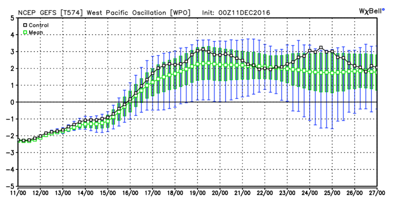
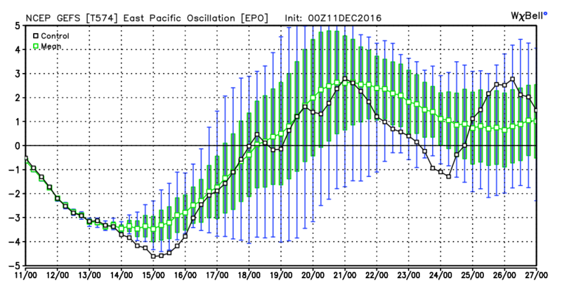
It will be very interesting to see if the cold really can come and actually hold. The majority of the telleconnections are trending poorly in the LR, but as I ve always said the LR tends to just be that. We shall see how they evolve once the heart of the cold is entrenched. Although the EPO is trending negative it seems to peek with late next week after which time both the EPO and WPO come back towards neutral/positve. Reload or product of the main drivers of the atmosphere is yet to be determined.
_________________
"In weather and in life, there's no winning and losing; there's only winning and learning."
WINTER 2012/2013 TOTALS 43.65"WINTER 2017/2018 TOTALS 62.85" WINTER 2022/2023 TOTALS 4.9"
WINTER 2013/2014 TOTALS 64.85"WINTER 2018/2019 TOTALS 14.25" WINTER 2023/2024 TOTALS 13.1"
WINTER 2014/2015 TOTALS 71.20"WINTER 2019/2020 TOTALS 6.35"
WINTER 2015/2016 TOTALS 35.00"WINTER 2020/2021 TOTALS 37.75"
WINTER 2016/2017 TOTALS 42.25"WINTER 2021/2022 TOTALS 31.65"

sroc4- Admin
- Posts : 8331
Reputation : 301
Join date : 2013-01-07
Location : Wading River, LI
Re: Long Range Thread 12.0
![]() by amugs Fri Dec 09, 2016 5:02 pm
by amugs Fri Dec 09, 2016 5:02 pm
Al like I said we are trending colder.
From Ventrice

_________________
Mugs
AKA:King: Snow Weenie
Self Proclaimed
WINTER 2014-15 : 55.12" +.02 for 6 coatings (avg. 35")
WINTER 2015-16 Total - 29.8" (Avg 35")
WINTER 2016-17 : 39.5" so far

amugs- Advanced Forecaster - Mod
- Posts : 15093
Reputation : 213
Join date : 2013-01-07
Age : 54
Location : Hillsdale,NJ
Re: Long Range Thread 12.0
![]() by algae888 Fri Dec 09, 2016 6:55 pm
by algae888 Fri Dec 09, 2016 6:55 pm

algae888- Advanced Forecaster

- Posts : 5311
Reputation : 46
Join date : 2013-02-05
Age : 61
Location : mt. vernon, new york
Re: Long Range Thread 12.0
![]() by amugs Fri Dec 09, 2016 10:39 pm
by amugs Fri Dec 09, 2016 10:39 pm

_________________
Mugs
AKA:King: Snow Weenie
Self Proclaimed
WINTER 2014-15 : 55.12" +.02 for 6 coatings (avg. 35")
WINTER 2015-16 Total - 29.8" (Avg 35")
WINTER 2016-17 : 39.5" so far
amugs- Advanced Forecaster - Mod
- Posts : 15093
Reputation : 213
Join date : 2013-01-07
Age : 54
Location : Hillsdale,NJ
Re: Long Range Thread 12.0
![]() by Frank_Wx Sat Dec 10, 2016 10:12 am
by Frank_Wx Sat Dec 10, 2016 10:12 am

GFS was out to sea

This a PV-driven event. Check out the location of the PV by Thursday morning. It is in southeast Canada. There is a ton of 500mb energy circulating the PV. All it takes is one piece to break off and phase with another vort from the Pacific.

Also important to note is it will be very cold. Snow ratios should be greater than 10:1, could be 15:1 or even 20:1 in N&W sections.
_________________
_______________________________________________________________________________________________________
CLICK HERE to view NJ Strong Snowstorm Classifications
Frank_Wx- Godzilla Seeker
- Posts : 21305
Reputation : 328
Join date : 2013-01-05
Age : 31
Location : Jersey City, NJ -
Re: Long Range Thread 12.0
![]() by amugs Sat Dec 10, 2016 10:37 am
by amugs Sat Dec 10, 2016 10:37 am
PV in SE Can and a N EPO and Pos PNA as well as a slight N NAO with Scandinavian block to the east of Greenland
.png)
_________________
Mugs
AKA:King: Snow Weenie
Self Proclaimed
WINTER 2014-15 : 55.12" +.02 for 6 coatings (avg. 35")
WINTER 2015-16 Total - 29.8" (Avg 35")
WINTER 2016-17 : 39.5" so far
amugs- Advanced Forecaster - Mod
- Posts : 15093
Reputation : 213
Join date : 2013-01-07
Age : 54
Location : Hillsdale,NJ
Re: Long Range Thread 12.0
![]() by jmanley32 Sat Dec 10, 2016 12:45 pm
by jmanley32 Sat Dec 10, 2016 12:45 pm

jmanley32- Senior Enthusiast
- Posts : 20517
Reputation : 108
Join date : 2013-12-12
Age : 42
Location : Yonkers, NY
Re: Long Range Thread 12.0
![]() by skinsfan1177 Sat Dec 10, 2016 12:56 pm
by skinsfan1177 Sat Dec 10, 2016 12:56 pm

skinsfan1177- Senior Enthusiast
- Posts : 4485
Reputation : 35
Join date : 2013-01-07
Age : 46
Location : Point Pleasant Boro
Re: Long Range Thread 12.0
![]() by jmanley32 Sat Dec 10, 2016 1:46 pm
by jmanley32 Sat Dec 10, 2016 1:46 pm
jmanley32- Senior Enthusiast
- Posts : 20517
Reputation : 108
Join date : 2013-12-12
Age : 42
Location : Yonkers, NY
track17- Posts : 454
Reputation : 4
Join date : 2016-01-09
Re: Long Range Thread 12.0
![]() by algae888 Sat Dec 10, 2016 7:22 pm
by algae888 Sat Dec 10, 2016 7:22 pm
Todays models are south except the cmc. Still time to trend better. Models should have a better handle on it in a couple of daystrack17 wrote:So what is the deal with Thursday
algae888- Advanced Forecaster
- Posts : 5311
Reputation : 46
Join date : 2013-02-05
Age : 61
Location : mt. vernon, new york
Re: Long Range Thread 12.0
![]() by jmanley32 Sat Dec 10, 2016 10:03 pm
by jmanley32 Sat Dec 10, 2016 10:03 pm
jmanley32- Senior Enthusiast
- Posts : 20517
Reputation : 108
Join date : 2013-12-12
Age : 42
Location : Yonkers, NY
Re: Long Range Thread 12.0
![]() by Frank_Wx Sat Dec 10, 2016 11:09 pm
by Frank_Wx Sat Dec 10, 2016 11:09 pm
It's been the 12th-20th for awhile now. Monday N&W will see a nice snow event, then attention turns to the 15th and 17th. The system on the 15th may get sheared out from the PV to our north. As the PV lifts north, that allows room for short waves to also come north and amplify with cold air in place. Like others, I agree the 17th is a better period to see a storm than the 15th.


_________________
_______________________________________________________________________________________________________
CLICK HERE to view NJ Strong Snowstorm Classifications
Frank_Wx- Godzilla Seeker
- Posts : 21305
Reputation : 328
Join date : 2013-01-05
Age : 31
Location : Jersey City, NJ -
Re: Long Range Thread 12.0
![]() by Guest Sat Dec 10, 2016 11:50 pm
by Guest Sat Dec 10, 2016 11:50 pm
Frank_Wx wrote:We're in a time crunch to try and pull off snow event next week, because it does look like after the 21st or so we'll see the return of the SE Ridge. Many are familiar with the details to this point so not worth repeating. The Trop PV will retreat back to the N Pole, causing the AO/NAO to shoot positive. The EURO takes it to almost +5 SD which is pretty remarkable. Meanwhile, we're seeing upper energy from Siberia continuing to follow the PAC jet and dig into the western U.S. This is a great wintry pattern for Chicago and that part of the country. They're actually getting a foot of snow tonight.
It's been the 12th-20th for awhile now. Monday N&W will see a nice snow event, then attention turns to the 15th and 17th. The system on the 15th may get sheared out from the PV to our north. As the PV lifts north, that allows room for short waves to also come north and amplify with cold air in place. Like others, I agree the 17th is a better period to see a storm than the 15th.
Guest- Guest
Re: Long Range Thread 12.0
![]() by sroc4 Sun Dec 11, 2016 8:13 am
by sroc4 Sun Dec 11, 2016 8:13 am
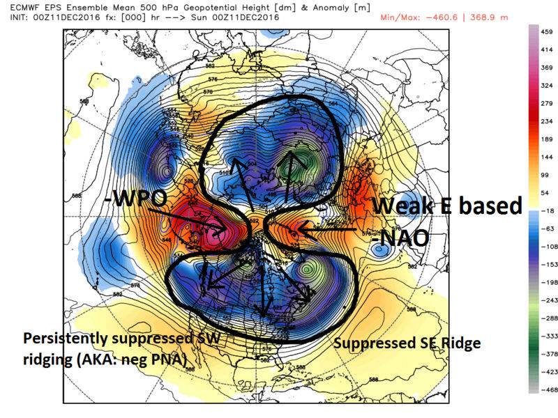
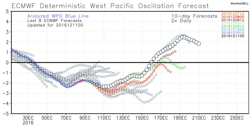
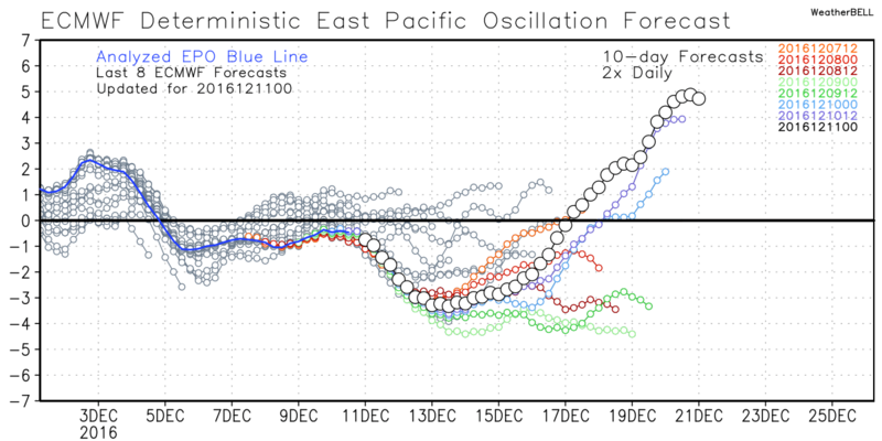
So what's up with the pattern. When talking about the pattern we always talk about "the drivers" vs the "enhancers". Up through late Oct and all of November the drivers to the pattern as a whole were the results of an unprecedented stratospheric warming event in Nov that sent the weakened strat vortex to the Asian side of the N Hemisphere, and the weak La Nina trop forcing conditions with smaller enhancers involved. So what's driving the pattern now? Simply stated the -WPO (Western Pacific Oscillation) decide it wanted to take over the driver seat for a period of time. The way it looks from my perspective is that the -WPO is like the teenage son in the back seat who convinced his parents to let him have a turn at the wheel. The question is how long is Jr going to be driving? I believe that the other main drivers will be back in the front seats once again. Modeling thinks it might be as early as around the 20th +/- a few days, but again I caution changes like this are often modeled too quick so I think end of the month is more likely but we will see. Now keep in mind just because we MAY fall back into a crappy pattern doesn't mean we wont have other "enhancers" take a turn behind the wheel, nor does it mean the drivers that bring us back to a crappy pattern cant or wont eventually become a driver for the better. (ie: stratosphere if we get another significant warming event in Jan).
Here is last nights EPS map valid for 00z today. Basically the current 500mb conditions showing how the -WPO poleward ridging has led to the arctic air masses to be pinched off and sent southward into NA on a cross polar flow. The cold in asia has been there since Nov because the weak strat PV has been sitting over there.
Now for those who think the La Nina is done or officially collapsed hold the phone. For at least the next month or so we will likely still see La Nina like conditions flare up, esp when other drivers or enhancers relax like we will likely see to the -WPO in the not so distant future. La nina like Walker circulations, although have been weak, remain present in the background as seen by the OLR maps and current observations with convection over 120E and the lack of around the dateline.

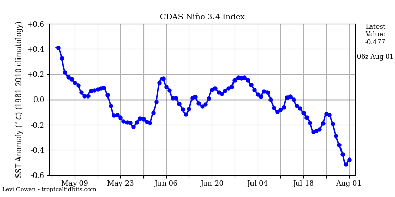
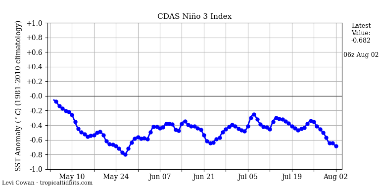
SST despite abruptly warming over a two week period just as abruptly seem to be coming back down to nearly where they were; esp in Nino regions 3.4 and 3.
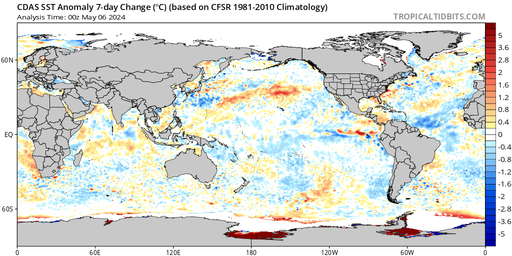
CURRENT SSTA:

LAST 7 DAY CHANGE IN SSTA:


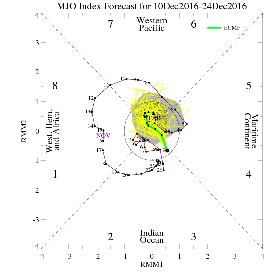
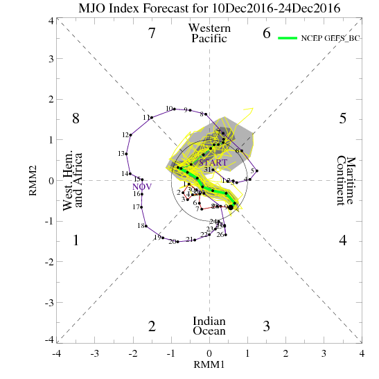
The MJO has had little to no effect on the pattern as a whole as it has been in the COD for some time. Forecasts indicate it may re-emerge in phases5/6 which are typical of La Nina years and ridging in the E CONUS. That said I have been following the LR MJO forecasts for the last several weeks and there seems to always be hints of it coming out of the COD in the LR in one phase or another but so far it has remained there. Basically this means the MJO has had little to no influence on the big picture over the last few weeks. That said with other factors in the atmosphere changing the MJO might have a chance to flare up with a pulse and become more influential. Well see
Now its really between days 5-10 that we see the collapse of the -WPO ridging. Following the collapse of this ridge the N Pac looks to fall back to the same look it had in the month of November with abroad trough across much of the N Pac by about the 20th-23rd. This brings us back to the screaming N Pac jet flooding the western CONUS with Pac air. Again I hesitate to take the timing of all this as gospel.
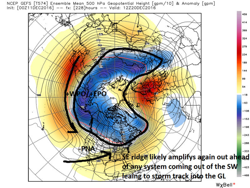
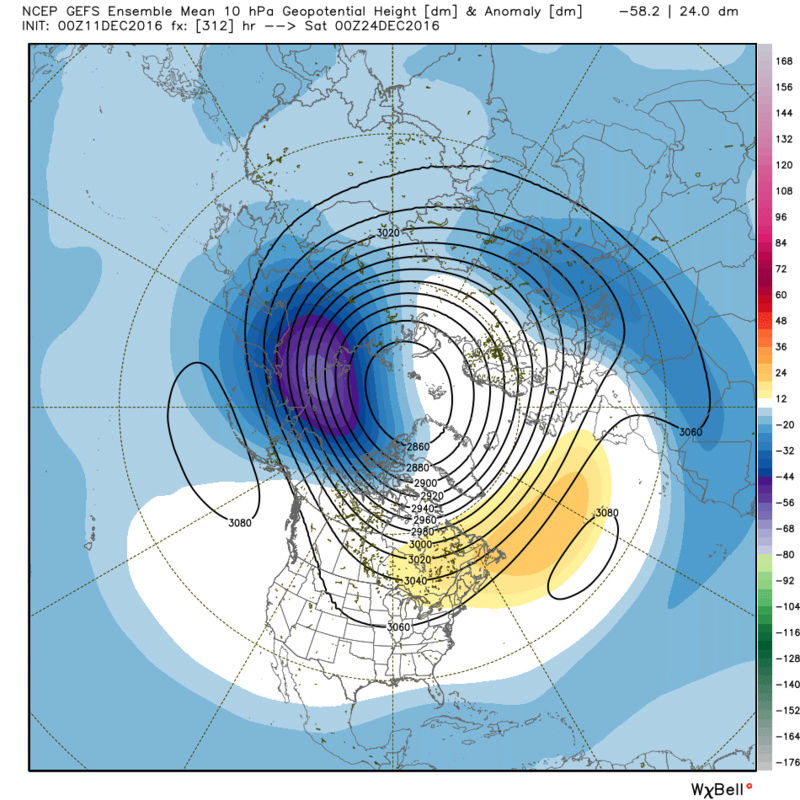
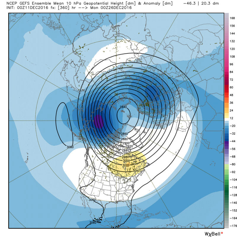
Lets just briefly look at the Strat forecasts as well. Tom (Isotherm) has been predicting this for some time now and unfort its showing up on the LR projections finally. That is the re-emergence and consolidation of the Stratospheric PV over the N Pole and it becomes incredibly strong. This will likely lock up all cold over the arctic should it come to fruition, without any other external factors affecting the pattern down below in the troposphere. Again these images are days 12-15 so a lot can change.


I know it typically takes alot to change the pattern once it becomes entrenched, but I see too many neg indicators to sustain the below normal temps beyond late month. It may take longer than is currently modeled to come back, warmer than normal NE, but it is coming once again because again I believe the -WPO poleward ridge is a mere teenager behind the wheel and the big daddy and momma will take back over the drivers seat. We may have to hope that we get a strong strat warming event in Jan to disrupt the PV again to re shuffle the drivers. Maybe Tom or Frank can give an updated status on this potential for January. We still have a lot of winter to go so no need to hit the panic button, but expect a period of normal to above normal yet again.
_________________
"In weather and in life, there's no winning and losing; there's only winning and learning."
WINTER 2012/2013 TOTALS 43.65"WINTER 2017/2018 TOTALS 62.85" WINTER 2022/2023 TOTALS 4.9"
WINTER 2013/2014 TOTALS 64.85"WINTER 2018/2019 TOTALS 14.25" WINTER 2023/2024 TOTALS 13.1"
WINTER 2014/2015 TOTALS 71.20"WINTER 2019/2020 TOTALS 6.35"
WINTER 2015/2016 TOTALS 35.00"WINTER 2020/2021 TOTALS 37.75"
WINTER 2016/2017 TOTALS 42.25"WINTER 2021/2022 TOTALS 31.65"
sroc4- Admin
- Posts : 8331
Reputation : 301
Join date : 2013-01-07
Location : Wading River, LI
Re: Long Range Thread 12.0
![]() by amugs Sun Dec 11, 2016 8:41 am
by amugs Sun Dec 11, 2016 8:41 am
SE Ridge takes over as we lose our PAC Block - forget the Atlantic it has been god awful since 2010-11 overall.
One thing is for sure though this weeks cold will be very impressive for this time of year at the from middle till about the 18th/19th.
No mechanism to lock in the cold -what a shame.
Friday morning

_________________
Mugs
AKA:King: Snow Weenie
Self Proclaimed
WINTER 2014-15 : 55.12" +.02 for 6 coatings (avg. 35")
WINTER 2015-16 Total - 29.8" (Avg 35")
WINTER 2016-17 : 39.5" so far
amugs- Advanced Forecaster - Mod
- Posts : 15093
Reputation : 213
Join date : 2013-01-07
Age : 54
Location : Hillsdale,NJ
Re: Long Range Thread 12.0
![]() by sroc4 Sun Dec 11, 2016 9:41 am
by sroc4 Sun Dec 11, 2016 9:41 am
_________________
"In weather and in life, there's no winning and losing; there's only winning and learning."
WINTER 2012/2013 TOTALS 43.65"WINTER 2017/2018 TOTALS 62.85" WINTER 2022/2023 TOTALS 4.9"
WINTER 2013/2014 TOTALS 64.85"WINTER 2018/2019 TOTALS 14.25" WINTER 2023/2024 TOTALS 13.1"
WINTER 2014/2015 TOTALS 71.20"WINTER 2019/2020 TOTALS 6.35"
WINTER 2015/2016 TOTALS 35.00"WINTER 2020/2021 TOTALS 37.75"
WINTER 2016/2017 TOTALS 42.25"WINTER 2021/2022 TOTALS 31.65"
sroc4- Admin
- Posts : 8331
Reputation : 301
Join date : 2013-01-07
Location : Wading River, LI
Re: Long Range Thread 12.0
![]() by docstox12 Sun Dec 11, 2016 9:47 am
by docstox12 Sun Dec 11, 2016 9:47 am
sroc4 wrote:With all the negative I posted above I will say this. There are some indicators in the Euro weeklies that the timeframe after the New year may feature a -NAO which could still get us back to N to below normal. And if there truly is a west based -NAO actual snow storm chances too. Whether is the EPO/WPO region and/or the NAO/AO region we need some kind of blocking to get the cold air to come down. Again its all long range so things can and will likely change. At least we have the next 7-10days to keep our minds off of things.
Yes, Doc, we do have a nice cold December which is great for the Christmas spirit.Frank mentions a possible event for the weekend coming and, as you suggested in your excellent write up above, the shift to milder may be delayed.In any event, even if it flips milder, there is a LOT of winter ahead of us and late Jan-late Feb is normally the big time producer for snow around here.
Glass is half full!!!!!!

docstox12- Wx Statistician Guru

- Posts : 8507
Reputation : 222
Join date : 2013-01-07
Age : 73
Location : Monroe NY
Re: Long Range Thread 12.0
![]() by Frank_Wx Sun Dec 11, 2016 10:17 am
by Frank_Wx Sun Dec 11, 2016 10:17 am
_________________
_______________________________________________________________________________________________________
CLICK HERE to view NJ Strong Snowstorm Classifications
Frank_Wx- Godzilla Seeker
- Posts : 21305
Reputation : 328
Join date : 2013-01-05
Age : 31
Location : Jersey City, NJ -
Re: Long Range Thread 12.0
![]() by Frank_Wx Sun Dec 11, 2016 10:21 am
by Frank_Wx Sun Dec 11, 2016 10:21 am
Brutal.
_________________
_______________________________________________________________________________________________________
CLICK HERE to view NJ Strong Snowstorm Classifications
Frank_Wx- Godzilla Seeker
- Posts : 21305
Reputation : 328
Join date : 2013-01-05
Age : 31
Location : Jersey City, NJ -
Re: Long Range Thread 12.0
![]() by skinsfan1177 Sun Dec 11, 2016 10:41 am
by skinsfan1177 Sun Dec 11, 2016 10:41 am
skinsfan1177- Senior Enthusiast
- Posts : 4485
Reputation : 35
Join date : 2013-01-07
Age : 46
Location : Point Pleasant Boro
Re: Long Range Thread 12.0
![]() by Frank_Wx Sun Dec 11, 2016 11:25 am
by Frank_Wx Sun Dec 11, 2016 11:25 am
_________________
_______________________________________________________________________________________________________
CLICK HERE to view NJ Strong Snowstorm Classifications
Frank_Wx- Godzilla Seeker
- Posts : 21305
Reputation : 328
Join date : 2013-01-05
Age : 31
Location : Jersey City, NJ -
Re: Long Range Thread 12.0
![]() by Frank_Wx Sun Dec 11, 2016 1:34 pm
by Frank_Wx Sun Dec 11, 2016 1:34 pm

_________________
_______________________________________________________________________________________________________
CLICK HERE to view NJ Strong Snowstorm Classifications
Frank_Wx- Godzilla Seeker
- Posts : 21305
Reputation : 328
Join date : 2013-01-05
Age : 31
Location : Jersey City, NJ -
Page 35 of 40 • 1 ... 19 ... 34, 35, 36 ... 40 ![]()
|
|
|