
 Search
Long Range Thread 13.0
Page 2 of 40 •  1, 2, 3 ... 21 ... 40
 ![]()
Re: Long Range Thread 13.0
![]() by rb924119 Sat Dec 24, 2016 9:45 am
by rb924119 Sat Dec 24, 2016 9:45 am
I don't know how much I'll be posting over the next few days, but as you said and I'll re-echo: Merry Christmas everybody!!
rb924119- Meteorologist

- Posts : 6889
Join date : 2013-02-06
Re: Long Range Thread 13.0
![]() by sroc4 Sat Dec 24, 2016 9:52 am
by sroc4 Sat Dec 24, 2016 9:52 am
rb924119 wrote:Great summary and discussion!! Just to clarify, the Aleutian ridge isn't a Rex block; it's more of an omega. The actual Rex block is in the PNA region as the upper-level low slips beneath the ridge. That's the Rex block I referenced a couple of days ago.
I don't know how much I'll be posting over the next few days, but as you said and I'll re-echo: Merry Christmas everybody!!
Thanks for clarifying so is it 90degrees turned right to see the omega? I was under the impression that a High over top of a low was Rex?
sroc4- Admin

- Posts : 8331
Join date : 2013-01-07
Re: Long Range Thread 13.0
![]() by Frank_Wx Sat Dec 24, 2016 10:09 am
by Frank_Wx Sat Dec 24, 2016 10:09 am
_________________
_______________________________________________________________________________________________________
CLICK HERE to view NJ Strong Snowstorm Classifications

Frank_Wx- Godzilla Seeker
- Posts : 21305
Reputation : 328
Join date : 2013-01-05
Age : 31
Location : Jersey City, NJ -

Re: Long Range Thread 13.0
![]() by rb924119 Sat Dec 24, 2016 10:12 am
by rb924119 Sat Dec 24, 2016 10:12 am
To an unrelated point, Bobby had asked yesterday if there was some invisible hurricane that passed through Tahiti. Well, he was right; it's actually an Invest lmao the SOI, while still somewhat negative, has calmed significantly as that system is progressing westward. Also, the Rossby wave that I spoke about in my video is the same energy that has since spawned that typhoon in the western Pacific. Amazing to see just how fluid and dynamic this atmosphere really is.
rb924119- Meteorologist
- Posts : 6889
Reputation : 194
Join date : 2013-02-06
Age : 32
Location : Greentown, Pa
Re: Long Range Thread 13.0
![]() by Armando Salvadore Sat Dec 24, 2016 10:15 am
by Armando Salvadore Sat Dec 24, 2016 10:15 am
That was some fantastic analysis! Interesting trends on both OP and even the ensembles for that time period. Also aligns nicely that this time period is just coming off the jet extension across the pacific. Looking at the 250mb 06z GFS, an apparent split flow and jet streak intersect the ridge at H5.
It's the timeframe afterwards around the 1st-3rd that is intriguing. We see an anomalous poleward ridge extend into Alaska in conjunction with a split flow. Taken from the 0z EURO, that ULL energy kicks east ( ULL in SW CONUS), with a digging vorticity on a backside of the trough over the Great Lakes. That same energy for the 30th window, now kicks east and into the western atlantic, allowing for a ridge to extend poleward into Greenland and quite the impressive look verbatim the 0z EURO. Also, the western ridge now basically extends into NW Canada with a trough hanging off the West Coast. So, two intriguing time periods noted here, but is it possible one sets up the next?
Also, a +PNA is supported by induced poleward momentum and easterlies near ~ 30N from a +MT event off East Asia, which is supported by guidance showing a jet retraction. Guidance is beginning to figure it out, but definitely be cautious with guidance in the medium range as everyone knows the drill by now!
Apologize for not being able to show visuals because of my new membership, sorry folks! Have to wait it out. Hopefully the explanation is sufficient!
By the way, Merry Christmas to everyone!!!!

Armando Salvadore- Advanced Forecaster

- Posts : 171
Reputation : 0
Join date : 2016-12-23
Location : Springfield, NJ
Re: Long Range Thread 13.0
![]() by rb924119 Sat Dec 24, 2016 10:17 am
by rb924119 Sat Dec 24, 2016 10:17 am
Frank_Wx wrote:That Baja upper low is going to kill our storm threat on the 29th, isn't it?
That's what I was and am afraid of. While it will get cold into the East, it will keep the ridge too broad which increases the confluence across the Southeast. This keeps the flow flat and the trough too broad to allow anything to dive and then "turn the corner" until it's too late. We need that energy to either not be there at all and just have a true PNA, OR move the Rex further west. The second option, while not helping the issue of broadness and confluence, will shift all of the axes further west with it, which would bring the meridional part of the trough closer to our area.
rb924119- Meteorologist
- Posts : 6889
Reputation : 194
Join date : 2013-02-06
Age : 32
Location : Greentown, Pa
Re: Long Range Thread 13.0
![]() by Frank_Wx Sat Dec 24, 2016 11:08 am
by Frank_Wx Sat Dec 24, 2016 11:08 am
@Scott - here's a tweet I just made to highlight the differences you brought to light
https://twitter.com/nj_strong_wx/status/812690732695900161
Moral of the story, the 29th-30th time frame is at risk of being an all rain event because the trough does not deepen enough over the east coast for the reasons Scott and Ray talked about. That cut-off low near California disconfigures the upper pattern, essentially.
_________________
_______________________________________________________________________________________________________
CLICK HERE to view NJ Strong Snowstorm Classifications
Frank_Wx- Godzilla Seeker
- Posts : 21305
Reputation : 328
Join date : 2013-01-05
Age : 31
Location : Jersey City, NJ -
Re: Long Range Thread 13.0
![]() by Frank_Wx Sat Dec 24, 2016 11:11 am
by Frank_Wx Sat Dec 24, 2016 11:11 am
Armando Salvadore wrote:
That was some fantastic analysis! Interesting trends on both OP and even the ensembles for that time period. Also aligns nicely that this time period is just coming off the jet extension across the pacific. Looking at the 250mb 06z GFS, an apparent split flow and jet streak intersect the ridge at H5.
It's the timeframe afterwards around the 1st-3rd that is intriguing. We see an anomalous poleward ridge extend into Alaska in conjunction with a split flow. Taken from the 0z EURO, that ULL energy kicks east ( ULL in SW CONUS), with a digging vorticity on a backside of the trough over the Great Lakes. That same energy for the 30th window, now kicks east and into the western atlantic, allowing for a ridge to extend poleward into Greenland and quite the impressive look verbatim the 0z EURO. Also, the western ridge now basically extends into NW Canada with a trough hanging off the West Coast. So, two intriguing time periods noted here, but is it possible one sets up the next?
Also, a +PNA is supported by induced poleward momentum and easterlies near ~ 30N from a +MT event off East Asia, which is supported by guidance showing a jet retraction. Guidance is beginning to figure it out, but definitely be cautious with guidance in the medium range as everyone knows the drill by now!
Apologize for not being able to show visuals because of my new membership, sorry folks! Have to wait it out. Hopefully the explanation is sufficient!
By the way, Merry Christmas to everyone!!!!
Thanks Armando.
The EPS do not seem too enthused with the 1st-3rd time frame just yet. The -EPO is real but downstream, we're seeing too much of a -PNA as energy rotating around the PV digs southward. This is where the maintenance of a +PNA would have been nice.
_________________
_______________________________________________________________________________________________________
CLICK HERE to view NJ Strong Snowstorm Classifications
Frank_Wx- Godzilla Seeker
- Posts : 21305
Reputation : 328
Join date : 2013-01-05
Age : 31
Location : Jersey City, NJ -
Re: Long Range Thread 13.0
![]() by Guest Sat Dec 24, 2016 11:26 am
by Guest Sat Dec 24, 2016 11:26 am
Frank_Wx wrote:Agree Ray.
@Scott - here's a tweet I just made to highlight the differences you brought to light
https://twitter.com/nj_strong_wx/status/812690732695900161
Moral of the story, the 29th-30th time frame is at risk of being an all rain event because the trough does not deepen enough over the east coast for the reasons Scott and Ray talked about. That cut-off low near California disconfigures the upper pattern, essentially.
YESS!!! and the EPS is not excited about the 2nd thru 5th time frame either....DOUBLE YES!!! plus a soaking rain and upper 30's on Christmas Eve!!!
Merry Christmas all!!
Guest- Guest
Re: Long Range Thread 13.0
![]() by Frank_Wx Sat Dec 24, 2016 11:29 am
by Frank_Wx Sat Dec 24, 2016 11:29 am
EURO D10 10hPa heights

GEFS D10 10hPa heights

_________________
_______________________________________________________________________________________________________
CLICK HERE to view NJ Strong Snowstorm Classifications
Frank_Wx- Godzilla Seeker
- Posts : 21305
Reputation : 328
Join date : 2013-01-05
Age : 31
Location : Jersey City, NJ -
Re: Long Range Thread 13.0
![]() by Frank_Wx Sat Dec 24, 2016 11:40 am
by Frank_Wx Sat Dec 24, 2016 11:40 am
syosnow94 wrote:Frank_Wx wrote:Agree Ray.
@Scott - here's a tweet I just made to highlight the differences you brought to light
https://twitter.com/nj_strong_wx/status/812690732695900161
Moral of the story, the 29th-30th time frame is at risk of being an all rain event because the trough does not deepen enough over the east coast for the reasons Scott and Ray talked about. That cut-off low near California disconfigures the upper pattern, essentially.
YESS!!! and the EPS is not excited about the 2nd thru 5th time frame either....DOUBLE YES!!! plus a soaking rain and upper 30's on Christmas Eve!!!
Merry Christmas all!!

On a serious note, it's very frustrating seeing these models trend unfavorably in the longer range. While the resurgence of the -EPO is real, it does not look like the Atlantic or PV will be cooperative. Check out this GIF I made. Keep an eye on the NW Pacific. Watch as the orange, or potential vorticity, tracks into the west coast. The PV location and the cut-off ridge over Alaska forces all the PVA south.
_________________
_______________________________________________________________________________________________________
CLICK HERE to view NJ Strong Snowstorm Classifications
Frank_Wx- Godzilla Seeker
- Posts : 21305
Reputation : 328
Join date : 2013-01-05
Age : 31
Location : Jersey City, NJ -
Re: Long Range Thread 13.0
![]() by Frank_Wx Sat Dec 24, 2016 11:49 am
by Frank_Wx Sat Dec 24, 2016 11:49 am

_________________
_______________________________________________________________________________________________________
CLICK HERE to view NJ Strong Snowstorm Classifications
Frank_Wx- Godzilla Seeker
- Posts : 21305
Reputation : 328
Join date : 2013-01-05
Age : 31
Location : Jersey City, NJ -
Re: Long Range Thread 13.0
![]() by sroc4 Sat Dec 24, 2016 12:00 pm
by sroc4 Sat Dec 24, 2016 12:00 pm
Armando Salvadore wrote:
That was some fantastic analysis! Interesting trends on both OP and even the ensembles for that time period. Also aligns nicely that this time period is just coming off the jet extension across the pacific. Looking at the 250mb 06z GFS, an apparent split flow and jet streak intersect the ridge at H5.
It's the timeframe afterwards around the 1st-3rd that is intriguing. We see an anomalous poleward ridge extend into Alaska in conjunction with a split flow. Taken from the 0z EURO, that ULL energy kicks east ( ULL in SW CONUS), with a digging vorticity on a backside of the trough over the Great Lakes. That same energy for the 30th window, now kicks east and into the western atlantic, allowing for a ridge to extend poleward into Greenland and quite the impressive look verbatim the 0z EURO. Also, the western ridge now basically extends into NW Canada with a trough hanging off the West Coast. So, two intriguing time periods noted here, but is it possible one sets up the next?
Also, a +PNA is supported by induced poleward momentum and easterlies near ~ 30N from a +MT event off East Asia, which is supported by guidance showing a jet retraction. Guidance is beginning to figure it out, but definitely be cautious with guidance in the medium range as everyone knows the drill by now!
Apologize for not being able to show visuals because of my new membership, sorry folks! Have to wait it out. Hopefully the explanation is sufficient!
By the way, Merry Christmas to everyone!!!!
When or if you figure out how to post graphics Id love an illustration of the area in your discussion I bolded above. Mountain Torque, I'm assuming this is what your referring to as a +MT event off east Asia, is something I am just starting to educate myself on. I have some very basic ideas of this concept but have a ways to go with it. At what level do I need to be looking at in the atmosphere to see this event your referring? And what time frame am I looking at? My assumption is between 300-150mb to see the western Pac jet extension and wave break as it traverses the Pac? And timing I am looking at it from about hr 72 on, and watching the Pac jet and northern latitude ridging amplify, and ultimately the entire down stream pattern amplify as a result. Also do you or anyone else have any sites with graphics showing the positive and negative AAM anomalies along a time line?
As far as what you are referring to in the 1st-3rd time frame, if only our SW CONUS energy, AKA potential PNA ridge killer in the 29th-30th time frame, would come out 18 or so hrs earlier we would be in business on last nights Euro op verbatim.

Last edited by sroc4 on Sat Dec 24, 2016 12:05 pm; edited 1 time in total
_________________
"In weather and in life, there's no winning and losing; there's only winning and learning."
WINTER 2012/2013 TOTALS 43.65"WINTER 2017/2018 TOTALS 62.85" WINTER 2022/2023 TOTALS 4.9"
WINTER 2013/2014 TOTALS 64.85"WINTER 2018/2019 TOTALS 14.25" WINTER 2023/2024 TOTALS 13.1"
WINTER 2014/2015 TOTALS 71.20"WINTER 2019/2020 TOTALS 6.35"
WINTER 2015/2016 TOTALS 35.00"WINTER 2020/2021 TOTALS 37.75"
WINTER 2016/2017 TOTALS 42.25"WINTER 2021/2022 TOTALS 31.65"

sroc4- Admin
- Posts : 8331
Reputation : 301
Join date : 2013-01-07
Location : Wading River, LI
Re: Long Range Thread 13.0
![]() by sroc4 Sat Dec 24, 2016 12:05 pm
by sroc4 Sat Dec 24, 2016 12:05 pm
Frank_Wx wrote:Agree Ray.
@Scott - here's a tweet I just made to highlight the differences you brought to light
https://twitter.com/nj_strong_wx/status/812690732695900161
Moral of the story, the 29th-30th time frame is at risk of being an all rain event because the trough does not deepen enough over the east coast for the reasons Scott and Ray talked about. That cut-off low near California disconfigures the upper pattern, essentially.
Nice!
_________________
"In weather and in life, there's no winning and losing; there's only winning and learning."
WINTER 2012/2013 TOTALS 43.65"WINTER 2017/2018 TOTALS 62.85" WINTER 2022/2023 TOTALS 4.9"
WINTER 2013/2014 TOTALS 64.85"WINTER 2018/2019 TOTALS 14.25" WINTER 2023/2024 TOTALS 13.1"
WINTER 2014/2015 TOTALS 71.20"WINTER 2019/2020 TOTALS 6.35"
WINTER 2015/2016 TOTALS 35.00"WINTER 2020/2021 TOTALS 37.75"
WINTER 2016/2017 TOTALS 42.25"WINTER 2021/2022 TOTALS 31.65"
sroc4- Admin
- Posts : 8331
Reputation : 301
Join date : 2013-01-07
Location : Wading River, LI
Re: Long Range Thread 13.0
![]() by sroc4 Sat Dec 24, 2016 12:06 pm
by sroc4 Sat Dec 24, 2016 12:06 pm
_________________
"In weather and in life, there's no winning and losing; there's only winning and learning."
WINTER 2012/2013 TOTALS 43.65"WINTER 2017/2018 TOTALS 62.85" WINTER 2022/2023 TOTALS 4.9"
WINTER 2013/2014 TOTALS 64.85"WINTER 2018/2019 TOTALS 14.25" WINTER 2023/2024 TOTALS 13.1"
WINTER 2014/2015 TOTALS 71.20"WINTER 2019/2020 TOTALS 6.35"
WINTER 2015/2016 TOTALS 35.00"WINTER 2020/2021 TOTALS 37.75"
WINTER 2016/2017 TOTALS 42.25"WINTER 2021/2022 TOTALS 31.65"
sroc4- Admin
- Posts : 8331
Reputation : 301
Join date : 2013-01-07
Location : Wading River, LI
Re: Long Range Thread 13.0
![]() by Frank_Wx Sat Dec 24, 2016 12:15 pm
by Frank_Wx Sat Dec 24, 2016 12:15 pm
_________________
_______________________________________________________________________________________________________
CLICK HERE to view NJ Strong Snowstorm Classifications
Frank_Wx- Godzilla Seeker
- Posts : 21305
Reputation : 328
Join date : 2013-01-05
Age : 31
Location : Jersey City, NJ -
Re: Long Range Thread 13.0
![]() by rb924119 Sat Dec 24, 2016 12:33 pm
by rb924119 Sat Dec 24, 2016 12:33 pm
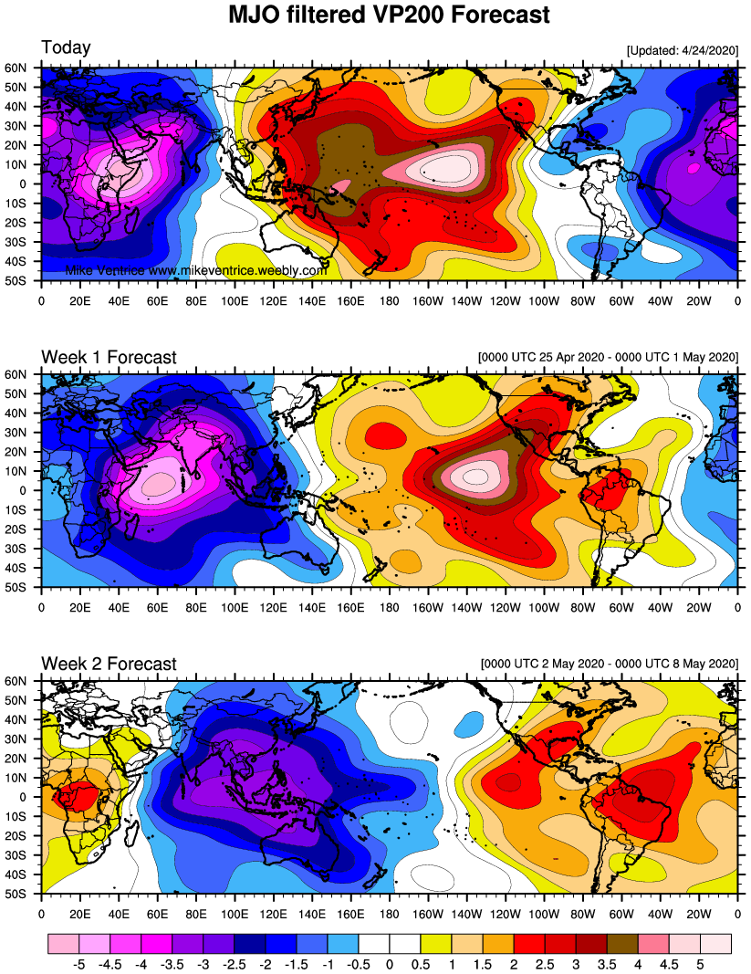
Frank_Wx wrote:RIP MJO? Looks like VP anomalies trend unfavorably.
The MJO does typically fade into phases 7/8
rb924119- Meteorologist
- Posts : 6889
Reputation : 194
Join date : 2013-02-06
Age : 32
Location : Greentown, Pa
Re: Long Range Thread 13.0
![]() by Armando Salvadore Sat Dec 24, 2016 12:56 pm
by Armando Salvadore Sat Dec 24, 2016 12:56 pm
P.S. (@sroc4, sent you a DM to answer your questions!)
Armando Salvadore- Advanced Forecaster
- Posts : 171
Reputation : 0
Join date : 2016-12-23
Location : Springfield, NJ
Re: Long Range Thread 13.0
![]() by jrollins628 Sat Dec 24, 2016 1:20 pm
by jrollins628 Sat Dec 24, 2016 1:20 pm
jrollins628- Posts : 38
Reputation : 0
Join date : 2016-10-05
Re: Long Range Thread 13.0
![]() by Frank_Wx Sat Dec 24, 2016 1:48 pm
by Frank_Wx Sat Dec 24, 2016 1:48 pm
jrollins628 wrote:I think it's safe to say that we need to take a break from the models and enjoy these next few days and allow models to adjust themselves accordingly. I have a feeling that we may see things change and stay that way around the 10th or so. But the moral of the story is I don't believe that things will change for NYE as some believed before they will. I'm no meteorologist so I cant say with certainty that will be the case. If your looking for good snow, it may not happen this year. One can hope but it does not look good. I suggest taking a step back from the models and enjoying the holiday with family and friends Merry Christmas and the models will be there on Monday lol
Good post, and to you too!
_________________
_______________________________________________________________________________________________________
CLICK HERE to view NJ Strong Snowstorm Classifications
Frank_Wx- Godzilla Seeker
- Posts : 21305
Reputation : 328
Join date : 2013-01-05
Age : 31
Location : Jersey City, NJ -
Re: Long Range Thread 13.0
![]() by Frank_Wx Sat Dec 24, 2016 1:50 pm
by Frank_Wx Sat Dec 24, 2016 1:50 pm

_________________
_______________________________________________________________________________________________________
CLICK HERE to view NJ Strong Snowstorm Classifications
Frank_Wx- Godzilla Seeker
- Posts : 21305
Reputation : 328
Join date : 2013-01-05
Age : 31
Location : Jersey City, NJ -
Re: Long Range Thread 13.0
![]() by algae888 Sat Dec 24, 2016 2:37 pm
by algae888 Sat Dec 24, 2016 2:37 pm

algae888- Advanced Forecaster
- Posts : 5311
Reputation : 46
Join date : 2013-02-05
Age : 61
Location : mt. vernon, new york
Re: Long Range Thread 13.0
![]() by algae888 Sat Dec 24, 2016 2:39 pm
by algae888 Sat Dec 24, 2016 2:39 pm
algae888- Advanced Forecaster
- Posts : 5311
Reputation : 46
Join date : 2013-02-05
Age : 61
Location : mt. vernon, new york
Re: Long Range Thread 13.0
![]() by jmanley32 Sat Dec 24, 2016 8:33 pm
by jmanley32 Sat Dec 24, 2016 8:33 pm
sroc I'm ashamed of u and I got knocked last yr for post st. I think u should b sent to timeout in oti lol. Merry xmas and don't for get happy haunnukah some here may b jewish ie. Half my family.sroc4 wrote:PS the illustrations I drew on this map were not intentionally done to look dirty..lol

jmanley32- Senior Enthusiast

- Posts : 20513
Reputation : 108
Join date : 2013-12-12
Age : 42
Location : Yonkers, NY

jake732- Pro Enthusiast

- Posts : 449
Reputation : 0
Join date : 2016-01-03
Location : lakewood, nj -
Re: Long Range Thread 13.0
![]() by Frank_Wx Sun Dec 25, 2016 3:37 pm
by Frank_Wx Sun Dec 25, 2016 3:37 pm
_________________
_______________________________________________________________________________________________________
CLICK HERE to view NJ Strong Snowstorm Classifications
Frank_Wx- Godzilla Seeker
- Posts : 21305
Reputation : 328
Join date : 2013-01-05
Age : 31
Location : Jersey City, NJ -
Re: Long Range Thread 13.0
![]() by Guest Sun Dec 25, 2016 7:08 pm
by Guest Sun Dec 25, 2016 7:08 pm
Frank_Wx wrote:Some hope to cling onto on this wonderful day. The GEFS show a -AO/-NAO/-EPO pattern setting up after January 7th. This would lead to substantial cold and frequent winter storm events. We shall see.
in 2 days we went from possibly a storm on the 30th or so to January 7th.
Guest- Guest
Page 2 of 40 • 1, 2, 3 ... 21 ... 40 ![]()
|
|
|