
 Search
Long Range Thread 12.0 (Split from original 12.0 Thread)
Page 3 of 5 •  1, 2, 3, 4, 5
 ![]()
Re: Long Range Thread 12.0 (Split from original 12.0 Thread)
![]() by Bobby Martrich EPAWA Wed Dec 21, 2016 11:29 am
by Bobby Martrich EPAWA Wed Dec 21, 2016 11:29 am
Bobby Martrich EPAWA- Meteorologist

- Posts : 36
Join date : 2016-12-19 -

Re: Long Range Thread 12.0 (Split from original 12.0 Thread)
![]() by Snow88 Wed Dec 21, 2016 12:36 pm
by Snow88 Wed Dec 21, 2016 12:36 pm
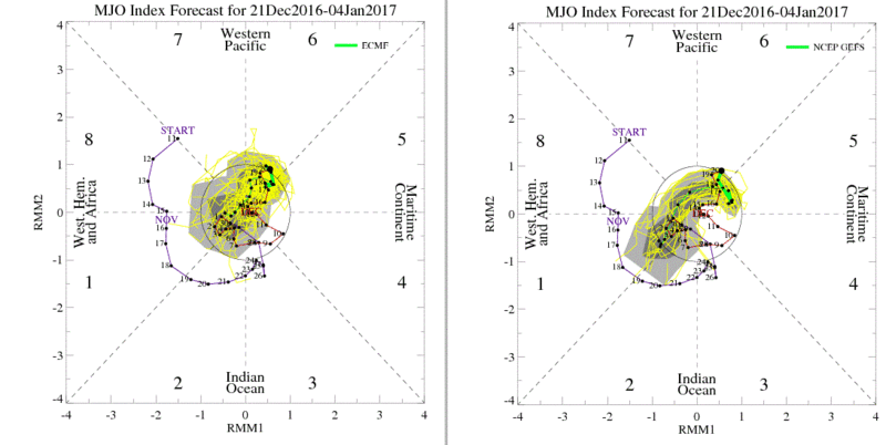
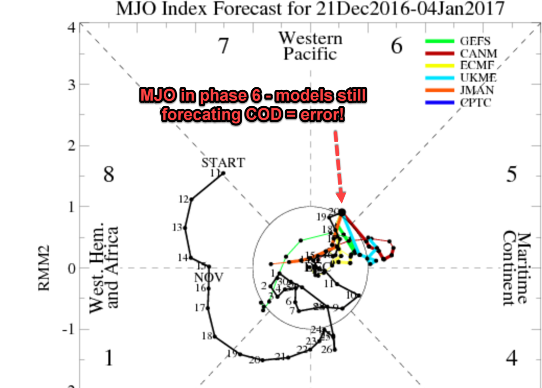
Last week they had the MJO staying in the COD
This is most likely playing tricks with the models. The models are most likely getting colder because of the MJO.
Snow88- Senior Enthusiast

- Posts : 2193
Join date : 2013-01-09
Re: Long Range Thread 12.0 (Split from original 12.0 Thread)
![]() by Frank_Wx Wed Dec 21, 2016 2:28 pm
by Frank_Wx Wed Dec 21, 2016 2:28 pm
Snow88 wrote:Wow
Last week they had the MJO staying in the COD
This is most likely playing tricks with the models. The models are most likely getting colder because of the MJO.
To me the new update looks like more members staying in the COD than before
_________________
_______________________________________________________________________________________________________
CLICK HERE to view NJ Strong Snowstorm Classifications

Frank_Wx- Godzilla Seeker

- Posts : 21305
Reputation : 328
Join date : 2013-01-05
Age : 31
Location : Jersey City, NJ -
Re: Long Range Thread 12.0 (Split from original 12.0 Thread)
![]() by amugs Wed Dec 21, 2016 2:41 pm
by amugs Wed Dec 21, 2016 2:41 pm

_________________
Mugs
AKA:King: Snow Weenie
Self Proclaimed
WINTER 2014-15 : 55.12" +.02 for 6 coatings (avg. 35")
WINTER 2015-16 Total - 29.8" (Avg 35")
WINTER 2016-17 : 39.5" so far

amugs- Advanced Forecaster - Mod

- Posts : 15093
Reputation : 213
Join date : 2013-01-07
Age : 54
Location : Hillsdale,NJ
Re: Long Range Thread 12.0 (Split from original 12.0 Thread)
![]() by amugs Wed Dec 21, 2016 2:51 pm
by amugs Wed Dec 21, 2016 2:51 pm
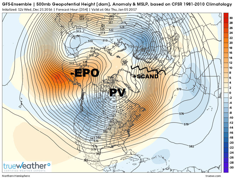
LP that is NW of Japan and Korean Penn is helping pump the Ridge over Alaska - Aleutians - is it what Scott so eloquently explained above ? Could very well be but it is 10000x better than what we were seeing a few days ago - shorter wavelengths as well.
Oh and this is the EURO depiction I am talking about. GEFS are on board as well - both 12Z suites showing this progression
_________________
Mugs
AKA:King: Snow Weenie
Self Proclaimed
WINTER 2014-15 : 55.12" +.02 for 6 coatings (avg. 35")
WINTER 2015-16 Total - 29.8" (Avg 35")
WINTER 2016-17 : 39.5" so far
amugs- Advanced Forecaster - Mod
- Posts : 15093
Reputation : 213
Join date : 2013-01-07
Age : 54
Location : Hillsdale,NJ
Re: Long Range Thread 12.0 (Split from original 12.0 Thread)
![]() by sroc4 Wed Dec 21, 2016 3:00 pm
by sroc4 Wed Dec 21, 2016 3:00 pm
It does look like the GFS forecasts the Easterlies, likely in response to the SOI spike occurring, are intensifying and pushing west over the next 10days.
Both the westerlies and easterlies seem to be trending west below the black forecast line, so the convergent zone bewteen the two also would in theory shift westward if this verifies. This could be one reason why the latest MJO forecast is less likely to come out of the COD in 5-6 and propagate east, but instead the end of the LR MJO forecast is now pointing more towards phase 1-3 instead of 6-8. Maybe Im reading this wrong however.
Bobby. I notice you posted the NCPE image and the ECMM from the CPC MJO site:

I wonder what you think of the NCPB image? This one is supposed to the the Bias-Corrected Ensemble Global Forecast System.

Watching these two over the past month I have notice there has been pretty big differences at times with regards to the LR forecast between the two only to see the NCPE trend towards the NCPB with time. As you can see there currently are fairly significant differences.
Vs the ECMF vs the ECMM which seem to be a little closer in LR forecast.


IMHO the GFS corrected, NCPB, has been much more accurate in the overall verification as LR becomes reality. Again Im skeptical that it makes it out of the COD.
_________________
"In weather and in life, there's no winning and losing; there's only winning and learning."
WINTER 2012/2013 TOTALS 43.65"WINTER 2017/2018 TOTALS 62.85" WINTER 2022/2023 TOTALS 4.9"
WINTER 2013/2014 TOTALS 64.85"WINTER 2018/2019 TOTALS 14.25" WINTER 2023/2024 TOTALS 13.1"
WINTER 2014/2015 TOTALS 71.20"WINTER 2019/2020 TOTALS 6.35"
WINTER 2015/2016 TOTALS 35.00"WINTER 2020/2021 TOTALS 37.75"
WINTER 2016/2017 TOTALS 42.25"WINTER 2021/2022 TOTALS 31.65"

sroc4- Admin
- Posts : 8331
Reputation : 301
Join date : 2013-01-07
Location : Wading River, LI
Re: Long Range Thread 12.0 (Split from original 12.0 Thread)
![]() by Bobby Martrich EPAWA Wed Dec 21, 2016 3:03 pm
by Bobby Martrich EPAWA Wed Dec 21, 2016 3:03 pm
And to answer your question, I think the bias corrected GEFS are probably a little bit more in line with the EPS, and probably a little bit more accurate. Although the mean stays in the circle of death, there are several spaghetti plots that are pointing toward a phase 1 look.
Last edited by Bobby Martrich EPAWA on Wed Dec 21, 2016 3:17 pm; edited 1 time in total

Bobby Martrich EPAWA- Meteorologist
- Posts : 36
Reputation : 0
Join date : 2016-12-19
Location : Allentown, PA -
Re: Long Range Thread 12.0 (Split from original 12.0 Thread)
![]() by sroc4 Wed Dec 21, 2016 3:15 pm
by sroc4 Wed Dec 21, 2016 3:15 pm
Bobby Martrich EPAWA wrote:Main takeaway and key takeaway isn't whether it remains in the circle of death or not, but the fact that it is moving the forcing away from the Maritime Continent.

_________________
"In weather and in life, there's no winning and losing; there's only winning and learning."
WINTER 2012/2013 TOTALS 43.65"WINTER 2017/2018 TOTALS 62.85" WINTER 2022/2023 TOTALS 4.9"
WINTER 2013/2014 TOTALS 64.85"WINTER 2018/2019 TOTALS 14.25" WINTER 2023/2024 TOTALS 13.1"
WINTER 2014/2015 TOTALS 71.20"WINTER 2019/2020 TOTALS 6.35"
WINTER 2015/2016 TOTALS 35.00"WINTER 2020/2021 TOTALS 37.75"
WINTER 2016/2017 TOTALS 42.25"WINTER 2021/2022 TOTALS 31.65"
sroc4- Admin
- Posts : 8331
Reputation : 301
Join date : 2013-01-07
Location : Wading River, LI
Re: Long Range Thread 12.0 (Split from original 12.0 Thread)
![]() by Bobby Martrich EPAWA Wed Dec 21, 2016 3:19 pm
by Bobby Martrich EPAWA Wed Dec 21, 2016 3:19 pm
Bobby Martrich EPAWA- Meteorologist
- Posts : 36
Reputation : 0
Join date : 2016-12-19
Location : Allentown, PA -
Re: Long Range Thread 12.0 (Split from original 12.0 Thread)
![]() by sroc4 Wed Dec 21, 2016 3:33 pm
by sroc4 Wed Dec 21, 2016 3:33 pm
Bobby Martrich EPAWA wrote:I edited my previous comment response because I missed the part about what you wrote directly to me. Sorry about that. Getting torn in 10 different directions today.
Unacceptable Bobby. JK thank you
_________________
"In weather and in life, there's no winning and losing; there's only winning and learning."
WINTER 2012/2013 TOTALS 43.65"WINTER 2017/2018 TOTALS 62.85" WINTER 2022/2023 TOTALS 4.9"
WINTER 2013/2014 TOTALS 64.85"WINTER 2018/2019 TOTALS 14.25" WINTER 2023/2024 TOTALS 13.1"
WINTER 2014/2015 TOTALS 71.20"WINTER 2019/2020 TOTALS 6.35"
WINTER 2015/2016 TOTALS 35.00"WINTER 2020/2021 TOTALS 37.75"
WINTER 2016/2017 TOTALS 42.25"WINTER 2021/2022 TOTALS 31.65"
sroc4- Admin
- Posts : 8331
Reputation : 301
Join date : 2013-01-07
Location : Wading River, LI
Re: Long Range Thread 12.0 (Split from original 12.0 Thread)
![]() by Bobby Martrich EPAWA Wed Dec 21, 2016 4:08 pm
by Bobby Martrich EPAWA Wed Dec 21, 2016 4:08 pm
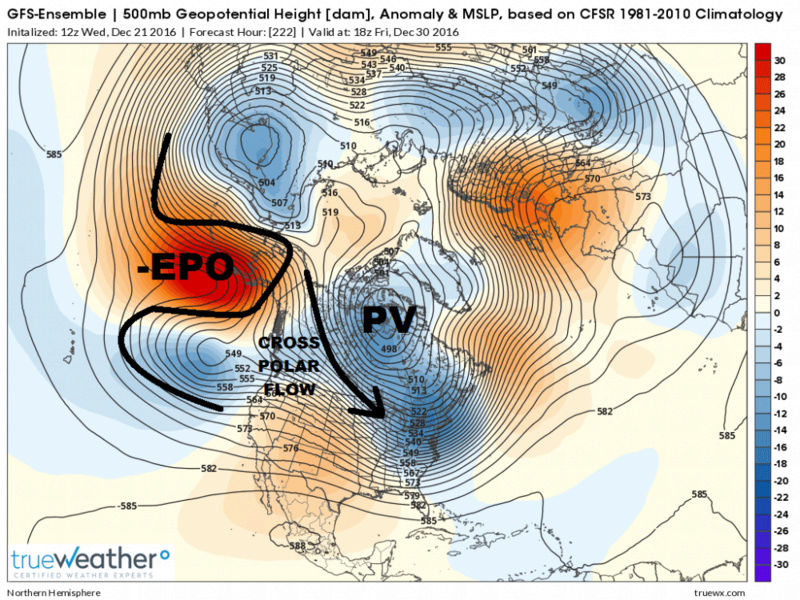
GEFS was also showing combo of -EPO and +SCAND D13-16, yet has SE ridge flex due to +NAO. Think it's overplaying ridge, and will adjust. They all will. First week of January will not be as previously advertised I'd be willing to bet. +SCAND although weak would combine with -EPO to promote EC troughiness, just don't think it's seeing yet. Still adjusting.
I think we'll continue to see changes in that first week of January look, may go back to near normal in these parts, but near normal for that time is mid-30s. Certainly cold enough to snow for at least interior.
EPS today not nearly as pronounced with that look, but with a -EPO I'll roll the dice and take my chances. I'd say below normal 12/30-1/2 and then near normal after that. Se ridge might be overkill here also with +NAO.
Bobby Martrich EPAWA- Meteorologist
- Posts : 36
Reputation : 0
Join date : 2016-12-19
Location : Allentown, PA -
Re: Long Range Thread 12.0 (Split from original 12.0 Thread)
![]() by Guest Wed Dec 21, 2016 4:19 pm
by Guest Wed Dec 21, 2016 4:19 pm
Guest- Guest
Re: Long Range Thread 12.0 (Split from original 12.0 Thread)
![]() by CPcantmeasuresnow Wed Dec 21, 2016 4:25 pm
by CPcantmeasuresnow Wed Dec 21, 2016 4:25 pm
syosnow94 wrote:Bobby welcome. Cute kid in the picture!! If you keep posting at this rate you will surpass Jman by the time we get our first significant snowstorm!! Fella's for the sake of guys like me, every once in awhile translate all these SOI, MJO, Rosby wave whatever you wanna call it mumbo jumbo, into english for us mortals. Simple good ole fashioned city talk please.
If I may add to this James as I did express similar thoughts to Mugs a couple of weeks ago.
A simple ending like, "This may be a positive for snow and cold", or "This is not a good look for snow and cold". Simple minds like mine need monarch notes.
I'm not sure anyone under 40 will get the monarch notes reference, but you get the idea.

CPcantmeasuresnow- Wx Statistician Guru

- Posts : 7274
Reputation : 230
Join date : 2013-01-07
Age : 103
Location : Eastern Orange County, NY
Re: Long Range Thread 12.0 (Split from original 12.0 Thread)
![]() by Bobby Martrich EPAWA Wed Dec 21, 2016 4:31 pm
by Bobby Martrich EPAWA Wed Dec 21, 2016 4:31 pm
Well the most recent pictures I showed were from the GEFS and EPS, and are definitely a colder look from about the 30th through about Jan 2nd... after that the models are trying to pump up the SE ridge again from Jan 3rd onward, which I call BS on. This is a chart that I shared with the premium forum members today, that breaks down the periods ahead with cold/warm periods and confidence of that occurring. Might make it more simple. This area is for eastern half of PA, all of NJ, all of DE, and the northernmost counties in MD near PA/MD border, our coverage area.

Bobby Martrich EPAWA- Meteorologist
- Posts : 36
Reputation : 0
Join date : 2016-12-19
Location : Allentown, PA -
Re: Long Range Thread 12.0 (Split from original 12.0 Thread)
![]() by rb924119 Wed Dec 21, 2016 4:34 pm
by rb924119 Wed Dec 21, 2016 4:34 pm
syosnow94 wrote:Bobby welcome. Cute kid in the picture!! If you keep posting at this rate you will surpass Jman by the time we get our first significant snowstorm!! Fella's for the sake of guys like me, every once in awhile translate all these SOI, MJO, Rosby wave whatever you wanna call it mumbo jumbo, into english for us mortals. Simple good ole fashioned city talk please.
The longer range, beyond the Christmas holiday, is looking more promising for, at the very least, equal amounts of cold and warm so that our region averages near normal through the same period that was supposed to be an all out torch a week ago. There are a couple signs that the cold may out duel the warmth and we could end up averaging slightly below normal temperatures, but whether they pan out remains to be seen. In terms of snowfall, nobody can say one way or the other, but if we end up averaging near normal temperatures we may end up seeing events similar to what we have so far; snow to to rain. If we average below normal temperatures, and we get timing right, we may be able to squeak out a snow event of some degree.
Better? Lol
rb924119- Meteorologist
- Posts : 6889
Reputation : 194
Join date : 2013-02-06
Age : 32
Location : Greentown, Pa
Re: Long Range Thread 12.0 (Split from original 12.0 Thread)
![]() by CPcantmeasuresnow Wed Dec 21, 2016 4:51 pm
by CPcantmeasuresnow Wed Dec 21, 2016 4:51 pm
CPcantmeasuresnow- Wx Statistician Guru
- Posts : 7274
Reputation : 230
Join date : 2013-01-07
Age : 103
Location : Eastern Orange County, NY
Re: Long Range Thread 12.0 (Split from original 12.0 Thread)
![]() by Frank_Wx Wed Dec 21, 2016 6:22 pm
by Frank_Wx Wed Dec 21, 2016 6:22 pm
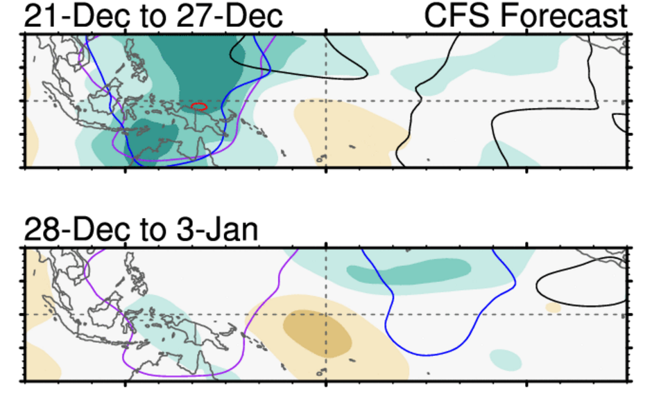
The CFS is forecasting little to no CHI, or vertical velocity, heading into New Years. This could mean the pattern we're heading into the end of this month is a transient period rather than one that could sustain itself into January.
What we're likely to see is the return of the -WPO/-EPO ridge but this time there may be a +PNA ridge to accompany it. This would concentrate the cold on the east coast and be a pretty good set-up for a winter storm. The western ridge is key. 500mb vorticity would travel over this ridge and into the backside of the eastern trough. Storms are less likely to cut to our west in this set-up. The only issue is models show this feature flexing for just a day before it collapses and moves east. There are a series of Pacific waves crashing into the PAC NW around this time frame as well. Timing has to be just right. And unfortunately the NAO looks to remain positive too.
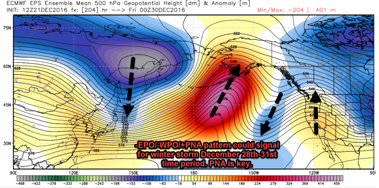
Models are already hinting at a possible winter storm in the 28th-31st time frame. Let's see if they hone in on a specific short wave in the next two days so we have an idea of what to keep an eye on.
_________________
_______________________________________________________________________________________________________
CLICK HERE to view NJ Strong Snowstorm Classifications
Frank_Wx- Godzilla Seeker
- Posts : 21305
Reputation : 328
Join date : 2013-01-05
Age : 31
Location : Jersey City, NJ -
Re: Long Range Thread 12.0 (Split from original 12.0 Thread)
![]() by Frank_Wx Thu Dec 22, 2016 12:01 am
by Frank_Wx Thu Dec 22, 2016 12:01 am

_________________
_______________________________________________________________________________________________________
CLICK HERE to view NJ Strong Snowstorm Classifications
Frank_Wx- Godzilla Seeker
- Posts : 21305
Reputation : 328
Join date : 2013-01-05
Age : 31
Location : Jersey City, NJ -
Re: Long Range Thread 12.0 (Split from original 12.0 Thread)
![]() by rb924119 Thu Dec 22, 2016 12:58 am
by rb924119 Thu Dec 22, 2016 12:58 am
Frank_Wx wrote:00z GFS has the -EPO/+PNA spikes at D10 still. The lack of Atlantic blocking makes it hard for cyclogensis to occur off the coast. We need to see the short waves consolidate further west to sharpen the trough up. Time period is 28th-30th.
We need that Rex block out of the PNA region I think for this to happen, though. As much as we would like to see it there for more sustained cold in the East, it keeps the ridge too broad which forces the trough axis further east. A nice, tall and skinny ridge would be perfect, not a Rex block UNLESS it centers more over the west coast of North America, then we'd have a shot at the best of both worlds.
rb924119- Meteorologist
- Posts : 6889
Reputation : 194
Join date : 2013-02-06
Age : 32
Location : Greentown, Pa
Re: Long Range Thread 12.0 (Split from original 12.0 Thread)
![]() by sroc4 Thu Dec 22, 2016 7:57 am
by sroc4 Thu Dec 22, 2016 7:57 am


I would imagine there is going to be a lot of model variations, esp in the operationals, as we cont to get closer to this time frame because we have to get past this on the 26th a mere 4 days or so, +/-, out ahead of it. With such a dynamic system cutting up into the N plains Id imagine the upper level features beyond this time frame will cont to waffle.


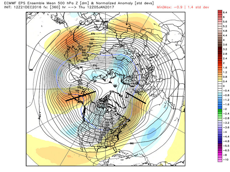
If you look at the LR beyond The new year If the height anomalies are true in the EPO region I expect a very similar trend as it gets closer IE: ridging into EPO region, +PNA with trough backing off west coast and piece breaking off and digging into CONUS. troughs into the east come and go but the pattern may rinse wash repeat. I stress MAY repeat.
Simply stated, (CP), there may be several opportunities for snow, and the overall temp departures will likely not be too bad at all.
Last edited by sroc4 on Thu Dec 22, 2016 8:05 am; edited 2 times in total
_________________
"In weather and in life, there's no winning and losing; there's only winning and learning."
WINTER 2012/2013 TOTALS 43.65"WINTER 2017/2018 TOTALS 62.85" WINTER 2022/2023 TOTALS 4.9"
WINTER 2013/2014 TOTALS 64.85"WINTER 2018/2019 TOTALS 14.25" WINTER 2023/2024 TOTALS 13.1"
WINTER 2014/2015 TOTALS 71.20"WINTER 2019/2020 TOTALS 6.35"
WINTER 2015/2016 TOTALS 35.00"WINTER 2020/2021 TOTALS 37.75"
WINTER 2016/2017 TOTALS 42.25"WINTER 2021/2022 TOTALS 31.65"
sroc4- Admin
- Posts : 8331
Reputation : 301
Join date : 2013-01-07
Location : Wading River, LI
Re: Long Range Thread 12.0 (Split from original 12.0 Thread)
![]() by sroc4 Thu Dec 22, 2016 8:00 am
by sroc4 Thu Dec 22, 2016 8:00 am


_________________
"In weather and in life, there's no winning and losing; there's only winning and learning."
WINTER 2012/2013 TOTALS 43.65"WINTER 2017/2018 TOTALS 62.85" WINTER 2022/2023 TOTALS 4.9"
WINTER 2013/2014 TOTALS 64.85"WINTER 2018/2019 TOTALS 14.25" WINTER 2023/2024 TOTALS 13.1"
WINTER 2014/2015 TOTALS 71.20"WINTER 2019/2020 TOTALS 6.35"
WINTER 2015/2016 TOTALS 35.00"WINTER 2020/2021 TOTALS 37.75"
WINTER 2016/2017 TOTALS 42.25"WINTER 2021/2022 TOTALS 31.65"
sroc4- Admin
- Posts : 8331
Reputation : 301
Join date : 2013-01-07
Location : Wading River, LI
Re: Long Range Thread 12.0 (Split from original 12.0 Thread)
![]() by amugs Thu Dec 22, 2016 8:46 am
by amugs Thu Dec 22, 2016 8:46 am

_________________
Mugs
AKA:King: Snow Weenie
Self Proclaimed
WINTER 2014-15 : 55.12" +.02 for 6 coatings (avg. 35")
WINTER 2015-16 Total - 29.8" (Avg 35")
WINTER 2016-17 : 39.5" so far
amugs- Advanced Forecaster - Mod
- Posts : 15093
Reputation : 213
Join date : 2013-01-07
Age : 54
Location : Hillsdale,NJ
Re: Long Range Thread 12.0 (Split from original 12.0 Thread)
![]() by algae888 Thu Dec 22, 2016 9:12 am
by algae888 Thu Dec 22, 2016 9:12 am


Last edited by algae888 on Thu Dec 22, 2016 9:18 am; edited 1 time in total

algae888- Advanced Forecaster

- Posts : 5311
Reputation : 46
Join date : 2013-02-05
Age : 61
Location : mt. vernon, new york
Re: Long Range Thread 12.0 (Split from original 12.0 Thread)
![]() by sroc4 Thu Dec 22, 2016 9:17 am
by sroc4 Thu Dec 22, 2016 9:17 am
algae888 wrote:Scott I would add that the Atlantic side looks much better too. No raging positive Nao if you look at the EPS at our 216 and Beyond it looks like a transient negative Nao or neutral at least. We need to get the Western Atlantic Ridge to move north. Eps better than the GEFS on this. Not that I'm a huge fan of a negative nao but we need all the help we can get. So basically on the Pacific side it's a relaxation and a reload. I keep reading and hearing that once the ridge forms there that it likes to stay there. Hopefully this is true this winter so we'll have plenty of cold air to work with.
Agreed on the NAO Al. The scandanavian ridge helps alot. I guess you canb argue for that being an East based block. In the images beyond the 10day I posted above show that block fading some, but my guess is that as we get closer and the wavelength shorten as the memebers come close together we see some form of blocking in this region, and or closer to greenland. A true -NAO west based im not so sure. I still think we can do ok without the NAO though if the pattern sets up like we have been discussing in the Pacific. This however would mean frequent over running or weak cyclogensis, without NA blocking. interesting none the less.
_________________
"In weather and in life, there's no winning and losing; there's only winning and learning."
WINTER 2012/2013 TOTALS 43.65"WINTER 2017/2018 TOTALS 62.85" WINTER 2022/2023 TOTALS 4.9"
WINTER 2013/2014 TOTALS 64.85"WINTER 2018/2019 TOTALS 14.25" WINTER 2023/2024 TOTALS 13.1"
WINTER 2014/2015 TOTALS 71.20"WINTER 2019/2020 TOTALS 6.35"
WINTER 2015/2016 TOTALS 35.00"WINTER 2020/2021 TOTALS 37.75"
WINTER 2016/2017 TOTALS 42.25"WINTER 2021/2022 TOTALS 31.65"
sroc4- Admin
- Posts : 8331
Reputation : 301
Join date : 2013-01-07
Location : Wading River, LI
Re: Long Range Thread 12.0 (Split from original 12.0 Thread)
![]() by rb924119 Thu Dec 22, 2016 9:33 am
by rb924119 Thu Dec 22, 2016 9:33 am
rb924119- Meteorologist
- Posts : 6889
Reputation : 194
Join date : 2013-02-06
Age : 32
Location : Greentown, Pa
Re: Long Range Thread 12.0 (Split from original 12.0 Thread)
![]() by amugs Thu Dec 22, 2016 9:36 am
by amugs Thu Dec 22, 2016 9:36 am
Look at the EPO - all that warmth goes to the pole and we block over teh top and hopefully connect a bridge between the PAC and Atlantic

_________________
Mugs
AKA:King: Snow Weenie
Self Proclaimed
WINTER 2014-15 : 55.12" +.02 for 6 coatings (avg. 35")
WINTER 2015-16 Total - 29.8" (Avg 35")
WINTER 2016-17 : 39.5" so far
amugs- Advanced Forecaster - Mod
- Posts : 15093
Reputation : 213
Join date : 2013-01-07
Age : 54
Location : Hillsdale,NJ
Re: Long Range Thread 12.0 (Split from original 12.0 Thread)
![]() by rb924119 Thu Dec 22, 2016 9:38 am
by rb924119 Thu Dec 22, 2016 9:38 am
rb924119- Meteorologist
- Posts : 6889
Reputation : 194
Join date : 2013-02-06
Age : 32
Location : Greentown, Pa
Page 3 of 5 • 1, 2, 3, 4, 5 ![]()
|
|
|