
 Search
Long Range Thread 13.0
Page 32 of 40 •  1 ... 17 ... 31, 32, 33 ... 36 ... 40
 ![]()
Re: Long Range Thread 13.0
![]() by Isotherm Thu Mar 02, 2017 3:13 pm
by Isotherm Thu Mar 02, 2017 3:13 pm
Isotherm- Advanced Forecaster

- Posts : 231
Join date : 2014-09-01 -

Re: Long Range Thread 13.0
![]() by algae888 Thu Mar 02, 2017 4:23 pm
by algae888 Thu Mar 02, 2017 4:23 pm
algae888- Advanced Forecaster
- Posts : 5311
Join date : 2013-02-05
Re: Long Range Thread 13.0
![]() by track17 Thu Mar 02, 2017 5:16 pm
by track17 Thu Mar 02, 2017 5:16 pm
track17- Posts : 454
Reputation : 4
Join date : 2016-01-09
Re: Long Range Thread 13.0
![]() by algae888 Thu Mar 02, 2017 5:49 pm
by algae888 Thu Mar 02, 2017 5:49 pm
If a storm goes underneath us with the block to our North and cold air in Canada it will snow. Obviously if a storm Cuts it's going to rain. The pattern we are entering now is different from the one all winter and it seems like it would only become more established over the next few weeks. Forecast highs and lows are useless more than several days out.track17 wrote:Has anyone looked at the temps the next two weeks. If you did you will see snow won't happen. All winter everyone said don't worry about the temps this far out. You know what those temps held or it was actually warmer. Don't say we have a chance for snow maybe the severe north but not 90 percent of the area

algae888- Advanced Forecaster
- Posts : 5311
Reputation : 46
Join date : 2013-02-05
Age : 61
Location : mt. vernon, new york
Re: Long Range Thread 13.0
![]() by sroc4 Thu Mar 02, 2017 5:56 pm
by sroc4 Thu Mar 02, 2017 5:56 pm
track17 wrote:Has anyone looked at the temps the next two weeks. If you did you will see snow won't happen. All winter everyone said don't worry about the temps this far out. You know what those temps held or it was actually warmer. Don't say we have a chance for snow maybe the severe north but not 90 percent of the area
Track this type of statement belongs in Banter. If you continue to post this sort of thing here it will be deleted. YOU CANNOT SIMPLY LOOK AT LR TEMPS AND SAY IT CAN OR CANT SNOW. Yes if a surface temp ends up at 50* IT WONT SNOW. But if the upper levels evolve such that a system comes together the temps profiles will change from what you see now. Again do not post this sort of post in this thread or it will be deleted.
_________________
"In weather and in life, there's no winning and losing; there's only winning and learning."
WINTER 2012/2013 TOTALS 43.65"WINTER 2017/2018 TOTALS 62.85" WINTER 2022/2023 TOTALS 4.9"
WINTER 2013/2014 TOTALS 64.85"WINTER 2018/2019 TOTALS 14.25" WINTER 2023/2024 TOTALS 13.1"
WINTER 2014/2015 TOTALS 71.20"WINTER 2019/2020 TOTALS 6.35"
WINTER 2015/2016 TOTALS 35.00"WINTER 2020/2021 TOTALS 37.75"
WINTER 2016/2017 TOTALS 42.25"WINTER 2021/2022 TOTALS 31.65"

sroc4- Admin

- Posts : 8331
Reputation : 301
Join date : 2013-01-07
Location : Wading River, LI
Re: Long Range Thread 13.0
![]() by devsman Thu Mar 02, 2017 6:19 pm
by devsman Thu Mar 02, 2017 6:19 pm

devsman- Pro Enthusiast

- Posts : 424
Reputation : 4
Join date : 2014-01-01
Age : 48
Location : merrick, ny (south shore of Long Island)
Re: Long Range Thread 13.0
![]() by Grselig Thu Mar 02, 2017 6:31 pm
by Grselig Thu Mar 02, 2017 6:31 pm
devsman wrote:If gfs is right, this can be a fun march for all!
Maybe.......blocking!!! I'd love a March 15 storm (my birthday)

Grselig- Senior Enthusiast

- Posts : 1408
Reputation : 140
Join date : 2013-03-04
Age : 54
Location : Wayne NJ
Re: Long Range Thread 13.0
![]() by Armando Salvadore Thu Mar 02, 2017 6:56 pm
by Armando Salvadore Thu Mar 02, 2017 6:56 pm
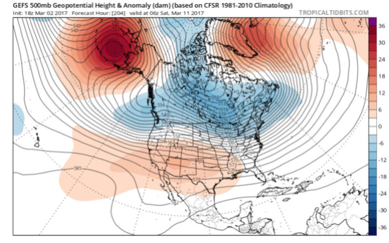
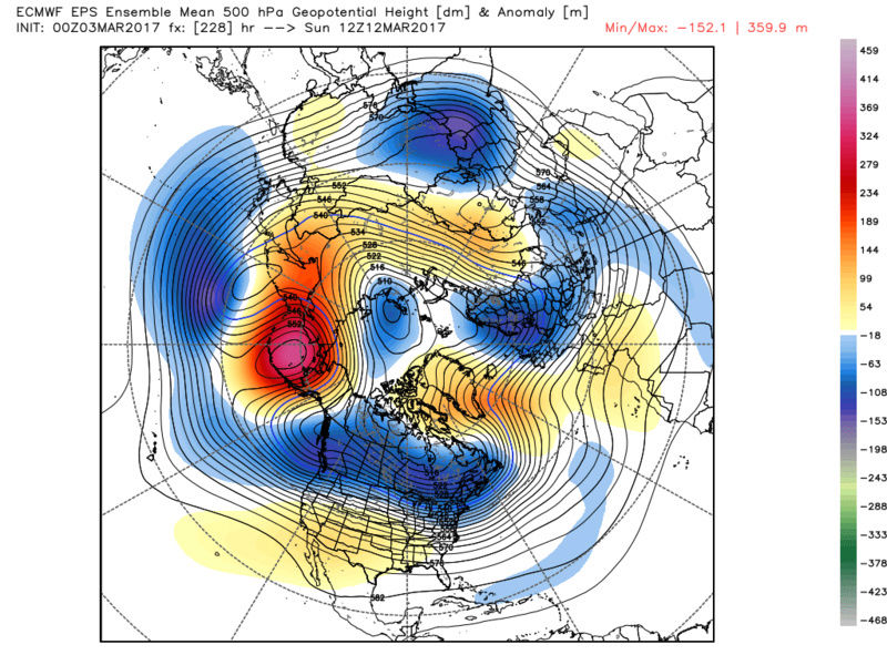
Isotherm wrote:Pattern recognition has superseded modelology throughout this winter, and there is no difference here. I would still be surprised if we evade a snow event with this pattern. The ECMWF has steadily improved with the NAO and concomitant 50/50, as well as more height rises out west. You don't need a meridional ridge spike to pole; a neutralizing PNA would be sufficient with this Atlantic set up. And yes, heights will rise in the SE US ahead of the propagating short wave, but as long as the confluent flow / attendent TPV lobe remains near Nove Scotia, that northern stream wave will be forced to transfer its energy southeastward. That's meteorology. We shall see how it plays out.
Tom, 12z EPS and 18Z GEFS do keep that north atlantic rossby wave configuration of most interest, and exactly as you said about the pacific and PNA domain. All you need is a PJ disturbance to hook with up induced confluent flow over SE canada via TPV, and yeah it makes it interesting. 18z GFS showed this exact statement perfectly. Squeeze the ridge between the davis strait and Greenland, and maybe we come out with at least one more event. Period i'd say to watch would be between 9th-12th. And yeah, about that EPS control.... lol

Armando Salvadore- Advanced Forecaster
- Posts : 171
Reputation : 0
Join date : 2016-12-23
Location : Springfield, NJ
Re: Long Range Thread 13.0
![]() by sroc4 Thu Mar 02, 2017 8:14 pm
by sroc4 Thu Mar 02, 2017 8:14 pm
_________________
"In weather and in life, there's no winning and losing; there's only winning and learning."
WINTER 2012/2013 TOTALS 43.65"WINTER 2017/2018 TOTALS 62.85" WINTER 2022/2023 TOTALS 4.9"
WINTER 2013/2014 TOTALS 64.85"WINTER 2018/2019 TOTALS 14.25" WINTER 2023/2024 TOTALS 13.1"
WINTER 2014/2015 TOTALS 71.20"WINTER 2019/2020 TOTALS 6.35"
WINTER 2015/2016 TOTALS 35.00"WINTER 2020/2021 TOTALS 37.75"
WINTER 2016/2017 TOTALS 42.25"WINTER 2021/2022 TOTALS 31.65"
sroc4- Admin
- Posts : 8331
Reputation : 301
Join date : 2013-01-07
Location : Wading River, LI
Re: Long Range Thread 13.0
![]() by skinsfan1177 Thu Mar 02, 2017 8:22 pm
by skinsfan1177 Thu Mar 02, 2017 8:22 pm

skinsfan1177- Senior Enthusiast
- Posts : 4485
Reputation : 35
Join date : 2013-01-07
Age : 46
Location : Point Pleasant Boro
Re: Long Range Thread 13.0
![]() by sroc4 Thu Mar 02, 2017 8:29 pm
by sroc4 Thu Mar 02, 2017 8:29 pm
skinsfan1177 wrote:I don't get how you can look at temps and make staements like this. patter reconition is key. cold air looks to get trapped beneath the block which I like
You cant Skins. Of course temp profiles can and do change often. We all know this. If you strictly look at temps over a 14day period to predict if it will snow well that's ones prerogative. I do not disagree it will be hard to get snow, but not because the temp forecast on my accuweather app says so. High temps Sat will hover around freezing on Sat with a low temp in the low teens or lower. Obviously it can snow with those temps, but it wont snow on Sat because there isn't any energy in the upper levels to trigger precip. Trolling will not be tolerated on this site. This is not directed at you Skins
_________________
"In weather and in life, there's no winning and losing; there's only winning and learning."
WINTER 2012/2013 TOTALS 43.65"WINTER 2017/2018 TOTALS 62.85" WINTER 2022/2023 TOTALS 4.9"
WINTER 2013/2014 TOTALS 64.85"WINTER 2018/2019 TOTALS 14.25" WINTER 2023/2024 TOTALS 13.1"
WINTER 2014/2015 TOTALS 71.20"WINTER 2019/2020 TOTALS 6.35"
WINTER 2015/2016 TOTALS 35.00"WINTER 2020/2021 TOTALS 37.75"
WINTER 2016/2017 TOTALS 42.25"WINTER 2021/2022 TOTALS 31.65"
sroc4- Admin
- Posts : 8331
Reputation : 301
Join date : 2013-01-07
Location : Wading River, LI
Re: Long Range Thread 13.0
![]() by track17 Thu Mar 02, 2017 8:54 pm
by track17 Thu Mar 02, 2017 8:54 pm
track17- Posts : 454
Reputation : 4
Join date : 2016-01-09
Re: Long Range Thread 13.0
![]() by skinsfan1177 Thu Mar 02, 2017 9:02 pm
by skinsfan1177 Thu Mar 02, 2017 9:02 pm
sroc4 wrote:skinsfan1177 wrote:I don't get how you can look at temps and make staements like this. patter reconition is key. cold air looks to get trapped beneath the block which I like
You cant Skins. Of course temp profiles can and do change often. We all know this. If you strictly look at temps over a 14day period to predict if it will snow well that's ones prerogative. I do not disagree it will be hard to get snow, but not because the temp forecast on my accuweather app says so. High temps Sat will hover around freezing on Sat with a low temp in the low teens or lower. Obviously it can snow with those temps, but it wont snow on Sat because there isn't any energy in the upper levels to trigger precip. Trolling will not be tolerated on this site. This is not directed at you Skins
I agree and I love your analysis and many others on here .
skinsfan1177- Senior Enthusiast
- Posts : 4485
Reputation : 35
Join date : 2013-01-07
Age : 46
Location : Point Pleasant Boro
Re: Long Range Thread 13.0
![]() by Math23x7 Thu Mar 02, 2017 10:47 pm
by Math23x7 Thu Mar 02, 2017 10:47 pm
Math23x7- Wx Statistician Guru

- Posts : 2379
Reputation : 68
Join date : 2013-01-08
Re: Long Range Thread 13.0
![]() by Frank_Wx Thu Mar 02, 2017 10:52 pm
by Frank_Wx Thu Mar 02, 2017 10:52 pm

_________________
_______________________________________________________________________________________________________
CLICK HERE to view NJ Strong Snowstorm Classifications

Frank_Wx- Godzilla Seeker
- Posts : 21305
Reputation : 328
Join date : 2013-01-05
Age : 31
Location : Jersey City, NJ -
skinsfan1177- Senior Enthusiast
- Posts : 4485
Reputation : 35
Join date : 2013-01-07
Age : 46
Location : Point Pleasant Boro
Re: Long Range Thread 13.0
![]() by Frank_Wx Fri Mar 03, 2017 8:11 am
by Frank_Wx Fri Mar 03, 2017 8:11 am
Frank_Wx wrote:Not going to lie...the 18z GFS was pretty gorgeous. That's an impressive signal and it's not even in the 'way' long range. You have Atlantic blocking with a transient ridge spike in the west. As mentioned yesterday, if you can time both to materialize at the same time then probability of seeing a snowstorm increases dramatically. Looking forward to waking up to hopefully see the 00z runs show something similar.
I woke up (thank the Lord), but the GFS and even other guidance do not look nearly as sexy. The Pacific continues to be the root cause to the problem.
_________________
_______________________________________________________________________________________________________
CLICK HERE to view NJ Strong Snowstorm Classifications
Frank_Wx- Godzilla Seeker
- Posts : 21305
Reputation : 328
Join date : 2013-01-05
Age : 31
Location : Jersey City, NJ -
Re: Long Range Thread 13.0
![]() by algae888 Fri Mar 03, 2017 9:30 am
by algae888 Fri Mar 03, 2017 9:30 am


yesterdays gefs..

algae888- Advanced Forecaster
- Posts : 5311
Reputation : 46
Join date : 2013-02-05
Age : 61
Location : mt. vernon, new york
Re: Long Range Thread 13.0
![]() by docstox12 Fri Mar 03, 2017 9:35 am
by docstox12 Fri Mar 03, 2017 9:35 am
algae888 wrote:frank the models have not backed off the blocking. it's still there just that the gefs have a stronger western trough compared to the eps. they have flipped in the last two days. interesting to see how this plays out!
yesterdays gefs..
OK, Al, still time to see if this can play out in a positive way for us.It will be fun to watch .

docstox12- Wx Statistician Guru
- Posts : 8507
Reputation : 222
Join date : 2013-01-07
Age : 73
Location : Monroe NY
Re: Long Range Thread 13.0
![]() by algae888 Fri Mar 03, 2017 9:36 am
by algae888 Fri Mar 03, 2017 9:36 am
6z gefs and yesterdays 6z gfs
block is much stronger. unless that western Canada trough gets really strong we should be in good shape.
and we are not done at this point. the pv will get trapped in central/eastern Canada moving through the next several days. so two time frames to watch. 7-9 day and 11-14 day. one last hurrah for the winter that wasn't
algae888- Advanced Forecaster
- Posts : 5311
Reputation : 46
Join date : 2013-02-05
Age : 61
Location : mt. vernon, new york
Re: Long Range Thread 13.0
![]() by Armando Salvadore Fri Mar 03, 2017 10:26 am
by Armando Salvadore Fri Mar 03, 2017 10:26 am
Armando Salvadore- Advanced Forecaster
- Posts : 171
Reputation : 0
Join date : 2016-12-23
Location : Springfield, NJ
Re: Long Range Thread 13.0
![]() by algae888 Fri Mar 03, 2017 11:59 am
by algae888 Fri Mar 03, 2017 11:59 am
Armando take a look at today's CMC while not as strong system very juicy something I think more likely to happen than not. GFS has flipped from a few days ago. Let's see what the Euro shows todayArmando Salvadore wrote:While not necessarily convinced for a big coastal, i can see how a PJ wave is timed perfectly with the back side of a trough for next weekend with this type of blocking showing up on the 0z EPS. As Tom said, even with a neutral PNA, the atlantic would need to compensate and it may just accomplish it.
algae888- Advanced Forecaster
- Posts : 5311
Reputation : 46
Join date : 2013-02-05
Age : 61
Location : mt. vernon, new york
Re: Long Range Thread 13.0
![]() by algae888 Fri Mar 03, 2017 12:28 pm
by algae888 Fri Mar 03, 2017 12:28 pm
algae888- Advanced Forecaster
- Posts : 5311
Reputation : 46
Join date : 2013-02-05
Age : 61
Location : mt. vernon, new york
Re: Long Range Thread 13.0
![]() by Frank_Wx Fri Mar 03, 2017 1:29 pm
by Frank_Wx Fri Mar 03, 2017 1:29 pm
A -NAO block in March is not going to bring the same affects to our pattern like a -NAO block in January during La Nina forcing events. As has been the winter pattern all season long, the Trop PV remains unfavorably placed which drives the cold into the western U.S. and polar jet north of our area. The QBO for February finished at +14 which I believe is a record. The Pacific Jet does not show many signs of slowing down. Again, snow threat exists between the 10th-15th but that's only if the PNA responds favorably. Last couple of model run paint an ugly picture. Given the seasonal trend, I would not get your hopes up.


_________________
_______________________________________________________________________________________________________
CLICK HERE to view NJ Strong Snowstorm Classifications
Frank_Wx- Godzilla Seeker
- Posts : 21305
Reputation : 328
Join date : 2013-01-05
Age : 31
Location : Jersey City, NJ -
Re: Long Range Thread 13.0
![]() by algae888 Fri Mar 03, 2017 1:31 pm
by algae888 Fri Mar 03, 2017 1:31 pm
algae888- Advanced Forecaster
- Posts : 5311
Reputation : 46
Join date : 2013-02-05
Age : 61
Location : mt. vernon, new york
Re: Long Range Thread 13.0
![]() by algae888 Fri Mar 03, 2017 1:38 pm
by algae888 Fri Mar 03, 2017 1:38 pm
algae888- Advanced Forecaster
- Posts : 5311
Reputation : 46
Join date : 2013-02-05
Age : 61
Location : mt. vernon, new york
Re: Long Range Thread 13.0
![]() by algae888 Fri Mar 03, 2017 1:45 pm
by algae888 Fri Mar 03, 2017 1:45 pm
algae888- Advanced Forecaster
- Posts : 5311
Reputation : 46
Join date : 2013-02-05
Age : 61
Location : mt. vernon, new york
Page 32 of 40 • 1 ... 17 ... 31, 32, 33 ... 36 ... 40 ![]()
|
|
|