
 Search
Tracking Hurricane Irma: Part 2
Page 17 of 21 •  1 ... 10 ... 16, 17, 18, 19, 20, 21
 ![]()
Re: Tracking Hurricane Irma: Part 2
![]() by docstox12 Sat Sep 09, 2017 7:44 am
by docstox12 Sat Sep 09, 2017 7:44 am
docstox12- Wx Statistician Guru

- Posts : 8502
Join date : 2013-01-07
Re: Tracking Hurricane Irma: Part 2
![]() by docstox12 Sat Sep 09, 2017 7:45 am
by docstox12 Sat Sep 09, 2017 7:45 am
sroc4 wrote:You can see her entire western flank took a hit from the land interaction, but she is actually back over open water for the moment. Her current movement looks like maybe back to a little more WNW instead of more W. Its going to be a really close call if she comes back over Cuba again or not.

Wow, Doc she is really going to have to make a sharp turn up the way it's moving west in these depictions.
docstox12- Wx Statistician Guru
- Posts : 8502
Join date : 2013-01-07
Re: Tracking Hurricane Irma: Part 2
![]() by sroc4 Sat Sep 09, 2017 7:50 am
by sroc4 Sat Sep 09, 2017 7:50 am
Images below are from lower to higher in altitude:


_________________
"In weather and in life, there's no winning and losing; there's only winning and learning."
WINTER 2012/2013 TOTALS 43.65"WINTER 2017/2018 TOTALS 62.85" WINTER 2022/2023 TOTALS 4.9"
WINTER 2013/2014 TOTALS 64.85"WINTER 2018/2019 TOTALS 14.25" WINTER 2023/2024 TOTALS 13.1"
WINTER 2014/2015 TOTALS 71.20"WINTER 2019/2020 TOTALS 6.35"
WINTER 2015/2016 TOTALS 35.00"WINTER 2020/2021 TOTALS 37.75"
WINTER 2016/2017 TOTALS 42.25"WINTER 2021/2022 TOTALS 31.65"

sroc4- Admin

- Posts : 8331
Reputation : 301
Join date : 2013-01-07
Location : Wading River, LI
Re: Tracking Hurricane Irma: Part 2
![]() by docstox12 Sat Sep 09, 2017 7:53 am
by docstox12 Sat Sep 09, 2017 7:53 am

docstox12- Wx Statistician Guru
- Posts : 8502
Reputation : 222
Join date : 2013-01-07
Age : 73
Location : Monroe NY
Re: Tracking Hurricane Irma: Part 2
![]() by sroc4 Sat Sep 09, 2017 7:57 am
by sroc4 Sat Sep 09, 2017 7:57 am
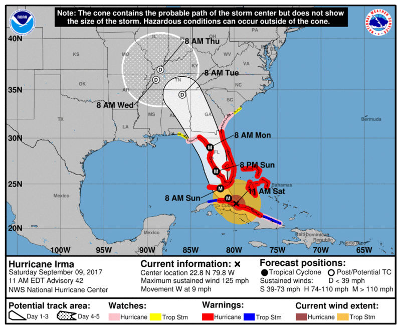
SUMMARY OF 800 AM EDT...1200 UTC...INFORMATION
----------------------------------------------
LOCATION...22.6N 79.6W
ABOUT 10 MI...15 KM NW OF CAIBARIEN CUBA
ABOUT 225 MI...365 KM S OF MIAMI FLORIDA
MAXIMUM SUSTAINED WINDS...130 MPH...215 KM/H
PRESENT MOVEMENT...WNW OR 275 DEGREES AT 12 MPH...19 KM/H
MINIMUM CENTRAL PRESSURE...937 MB...27.67 INCHES
_________________
"In weather and in life, there's no winning and losing; there's only winning and learning."
WINTER 2012/2013 TOTALS 43.65"WINTER 2017/2018 TOTALS 62.85" WINTER 2022/2023 TOTALS 4.9"
WINTER 2013/2014 TOTALS 64.85"WINTER 2018/2019 TOTALS 14.25" WINTER 2023/2024 TOTALS 13.1"
WINTER 2014/2015 TOTALS 71.20"WINTER 2019/2020 TOTALS 6.35"
WINTER 2015/2016 TOTALS 35.00"WINTER 2020/2021 TOTALS 37.75"
WINTER 2016/2017 TOTALS 42.25"WINTER 2021/2022 TOTALS 31.65"
sroc4- Admin
- Posts : 8331
Reputation : 301
Join date : 2013-01-07
Location : Wading River, LI
Re: Tracking Hurricane Irma: Part 2
![]() by Joe Snow Sat Sep 09, 2017 10:08 am
by Joe Snow Sat Sep 09, 2017 10:08 am
Yes she should be heading into open waters with warm temps Rocket fuel for her, I believe the temps go down 100' deep in the ocean so she should undoubtedly regain strength.
We shall see...........

Joe Snow- Pro Enthusiast

- Posts : 924
Reputation : 7
Join date : 2014-02-12
Age : 62
Location : Sanford Florida, Fmrly Kings Park, NY
Re: Tracking Hurricane Irma: Part 2
![]() by algae888 Sat Sep 09, 2017 10:22 am
by algae888 Sat Sep 09, 2017 10:22 am

algae888- Advanced Forecaster

- Posts : 5311
Reputation : 46
Join date : 2013-02-05
Age : 61
Location : mt. vernon, new york
Re: Tracking Hurricane Irma: Part 2
![]() by algae888 Sat Sep 09, 2017 10:25 am
by algae888 Sat Sep 09, 2017 10:25 am
algae888- Advanced Forecaster
- Posts : 5311
Reputation : 46
Join date : 2013-02-05
Age : 61
Location : mt. vernon, new york
Re: Tracking Hurricane Irma: Part 2
![]() by amugs Sat Sep 09, 2017 10:36 am
by amugs Sat Sep 09, 2017 10:36 am
Let's see whathappens once she pulls away from Cuba. Low shear and hot eater. If she stays more west and her eye stays over water then she can really ramp up as she moves North. Time will tell but not as ominous as a few days ago for the EC of Fla.
_________________
Mugs
AKA:King: Snow Weenie
Self Proclaimed
WINTER 2014-15 : 55.12" +.02 for 6 coatings (avg. 35")
WINTER 2015-16 Total - 29.8" (Avg 35")
WINTER 2016-17 : 39.5" so far

amugs- Advanced Forecaster - Mod

- Posts : 15093
Reputation : 213
Join date : 2013-01-07
Age : 54
Location : Hillsdale,NJ
Re: Tracking Hurricane Irma: Part 2
![]() by amugs Sat Sep 09, 2017 10:39 am
by amugs Sat Sep 09, 2017 10:39 am
Yes and no and u may think I am nuts but if she is dud the NHC will.lose the general.public respect and will NOT heed warnings when the next one comes. There eill be outcry for $ lost etc. Look at Irene and Sandy up here case in point!!algae888 wrote:The eye wall has deteriorated. This is fantastic news hopefully she can sit there for a few hours and weaken even more
Yes we won't see the catastrophic damage once thought.
_________________
Mugs
AKA:King: Snow Weenie
Self Proclaimed
WINTER 2014-15 : 55.12" +.02 for 6 coatings (avg. 35")
WINTER 2015-16 Total - 29.8" (Avg 35")
WINTER 2016-17 : 39.5" so far
amugs- Advanced Forecaster - Mod
- Posts : 15093
Reputation : 213
Join date : 2013-01-07
Age : 54
Location : Hillsdale,NJ
Re: Tracking Hurricane Irma: Part 2
![]() by Math23x7 Sat Sep 09, 2017 10:45 am
by Math23x7 Sat Sep 09, 2017 10:45 am
Math23x7- Wx Statistician Guru
- Posts : 2379
Reputation : 68
Join date : 2013-01-08
Re: Tracking Hurricane Irma: Part 2
![]() by Dunnzoo Sat Sep 09, 2017 11:03 am
by Dunnzoo Sat Sep 09, 2017 11:03 am
amugs wrote:Yes and no and u may think I am nuts but if she is dud the NHC will.lose the general.public respect and will NOT heed warnings when the next one comes. There eill be outcry for $ lost etc. Look at Irene and Sandy up here case in point!!algae888 wrote:The eye wall has deteriorated. This is fantastic news hopefully she can sit there for a few hours and weaken even more
Yes we won't see the catastrophic damage once thought.
Maybe not on the east coast, but sorry, west coast will see catastrophic damage. 12' storm surge and 150 mph winds are no joke. My brother is now in the path of this BIT*H and I'm trying to get him to leave. I75 is now clear since everyone left and gas is available. 1 lost life is one too many. By Florida being proactive, people will see it's better to be safe than sorry and it won't be another Katrina... prayers for all in Florida.
_________________
Janet
Snowfall winter of 2023-2024 17.5"
Snowfall winter of 2022-2023 6.0"
Snowfall winter of 2021-2022 17.6" 1" sleet 2/25/22
Snowfall winter of 2020-2021 51.1"
Snowfall winter of 2019-2020 8.5"
Snowfall winter of 2018-2019 25.1"
Snowfall winter of 2017-2018 51.9"
Snowfall winter of 2016-2017 45.6"
Snowfall winter of 2015-2016 29.5"
Snowfall winter of 2014-2015 50.55"
Snowfall winter of 2013-2014 66.5"

Dunnzoo- Senior Enthusiast - Mod
- Posts : 4886
Reputation : 68
Join date : 2013-01-11
Age : 62
Location : Westwood, NJ
Re: Tracking Hurricane Irma: Part 2
![]() by Math23x7 Sat Sep 09, 2017 11:08 am
by Math23x7 Sat Sep 09, 2017 11:08 am
Math23x7- Wx Statistician Guru
- Posts : 2379
Reputation : 68
Join date : 2013-01-08
Re: Tracking Hurricane Irma: Part 2
![]() by Guest Sat Sep 09, 2017 11:09 am
by Guest Sat Sep 09, 2017 11:09 am
It sounds sick to say but if Irma doesn't hit as at least a cat4 and cause catastrophic damage ALL CREDIBILITY WILL BE LOST. Sucks to say but true.
Guest- Guest
Re: Tracking Hurricane Irma: Part 2
![]() by Dunnzoo Sat Sep 09, 2017 11:36 am
by Dunnzoo Sat Sep 09, 2017 11:36 am
Math23x7 wrote:Janet, the 11AM advisory has Irma moving due west. If it doesn't make a northward turn anytime soon, this will go down (for Florida) as one of the biggest busts in history.
That's a big IF. 11 am update still has a forecast up the coast. It was always going to be a quick sharp turn wherever that turn would be. Until I see it in the middle of the gulf, there is great concern for Florida. My brother's neighborhood just got added to the mandatory evacuation zone with estimated storm surge of 15-20'. He is at 14' elevation.
_________________
Janet
Snowfall winter of 2023-2024 17.5"
Snowfall winter of 2022-2023 6.0"
Snowfall winter of 2021-2022 17.6" 1" sleet 2/25/22
Snowfall winter of 2020-2021 51.1"
Snowfall winter of 2019-2020 8.5"
Snowfall winter of 2018-2019 25.1"
Snowfall winter of 2017-2018 51.9"
Snowfall winter of 2016-2017 45.6"
Snowfall winter of 2015-2016 29.5"
Snowfall winter of 2014-2015 50.55"
Snowfall winter of 2013-2014 66.5"
Dunnzoo- Senior Enthusiast - Mod
- Posts : 4886
Reputation : 68
Join date : 2013-01-11
Age : 62
Location : Westwood, NJ
Re: Tracking Hurricane Irma: Part 2
![]() by sroc4 Sat Sep 09, 2017 11:45 am
by sroc4 Sat Sep 09, 2017 11:45 am


Last edited by sroc4 on Sat Sep 09, 2017 12:00 pm; edited 1 time in total
_________________
"In weather and in life, there's no winning and losing; there's only winning and learning."
WINTER 2012/2013 TOTALS 43.65"WINTER 2017/2018 TOTALS 62.85" WINTER 2022/2023 TOTALS 4.9"
WINTER 2013/2014 TOTALS 64.85"WINTER 2018/2019 TOTALS 14.25" WINTER 2023/2024 TOTALS 13.1"
WINTER 2014/2015 TOTALS 71.20"WINTER 2019/2020 TOTALS 6.35"
WINTER 2015/2016 TOTALS 35.00"WINTER 2020/2021 TOTALS 37.75"
WINTER 2016/2017 TOTALS 42.25"WINTER 2021/2022 TOTALS 31.65"
sroc4- Admin
- Posts : 8331
Reputation : 301
Join date : 2013-01-07
Location : Wading River, LI
Re: Tracking Hurricane Irma: Part 2
![]() by SoulSingMG Sat Sep 09, 2017 11:54 am
by SoulSingMG Sat Sep 09, 2017 11:54 am

SoulSingMG- Senior Enthusiast

- Posts : 2853
Reputation : 74
Join date : 2013-12-11
Location : Long Island City, NY
Re: Tracking Hurricane Irma: Part 2
![]() by Nyi1058 Sat Sep 09, 2017 11:56 am
by Nyi1058 Sat Sep 09, 2017 11:56 am
amugs wrote:Yes and no and u may think I am nuts but if she is dud the NHC will.lose the general.public respect and will NOT heed warnings when the next one comes. There eill be outcry for $ lost etc. Look at Irene and Sandy up here case in point!!algae888 wrote:The eye wall has deteriorated. This is fantastic news hopefully she can sit there for a few hours and weaken even more
Yes we won't see the catastrophic damage once thought.
today's day and age the general public understands how hard it is to forecast a hurricane . Every news outlet is updating the info every hour . I think we still do not know exactly where the eye is going to hit . Hurricanes are obviously a lot more serious then the 12 inch snowstorms we all get excited about . I have a summer house in Montauk , I prepare for any potential strike from even a tropical storm. Better safe then sorry !
And to add again Great job here guys !!!!! I love this forum for the information!!!!!
Nyi1058- Posts : 86
Reputation : 3
Join date : 2013-12-04
Age : 49
Location : Port Jefferson Long Island
Re: Tracking Hurricane Irma: Part 2
![]() by sroc4 Sat Sep 09, 2017 12:03 pm
by sroc4 Sat Sep 09, 2017 12:03 pm


_________________
"In weather and in life, there's no winning and losing; there's only winning and learning."
WINTER 2012/2013 TOTALS 43.65"WINTER 2017/2018 TOTALS 62.85" WINTER 2022/2023 TOTALS 4.9"
WINTER 2013/2014 TOTALS 64.85"WINTER 2018/2019 TOTALS 14.25" WINTER 2023/2024 TOTALS 13.1"
WINTER 2014/2015 TOTALS 71.20"WINTER 2019/2020 TOTALS 6.35"
WINTER 2015/2016 TOTALS 35.00"WINTER 2020/2021 TOTALS 37.75"
WINTER 2016/2017 TOTALS 42.25"WINTER 2021/2022 TOTALS 31.65"
sroc4- Admin
- Posts : 8331
Reputation : 301
Join date : 2013-01-07
Location : Wading River, LI
Re: Tracking Hurricane Irma: Part 2
![]() by sroc4 Sat Sep 09, 2017 12:12 pm
by sroc4 Sat Sep 09, 2017 12:12 pm

_________________
"In weather and in life, there's no winning and losing; there's only winning and learning."
WINTER 2012/2013 TOTALS 43.65"WINTER 2017/2018 TOTALS 62.85" WINTER 2022/2023 TOTALS 4.9"
WINTER 2013/2014 TOTALS 64.85"WINTER 2018/2019 TOTALS 14.25" WINTER 2023/2024 TOTALS 13.1"
WINTER 2014/2015 TOTALS 71.20"WINTER 2019/2020 TOTALS 6.35"
WINTER 2015/2016 TOTALS 35.00"WINTER 2020/2021 TOTALS 37.75"
WINTER 2016/2017 TOTALS 42.25"WINTER 2021/2022 TOTALS 31.65"
sroc4- Admin
- Posts : 8331
Reputation : 301
Join date : 2013-01-07
Location : Wading River, LI
Re: Tracking Hurricane Irma: Part 2
![]() by WeatherBob Sat Sep 09, 2017 12:17 pm
by WeatherBob Sat Sep 09, 2017 12:17 pm

WeatherBob- Meteorologist

- Posts : 683
Reputation : 83
Join date : 2013-12-13
Location : Caldwell, NJ - NW Essex County - Altitude 500 FT
Re: Tracking Hurricane Irma: Part 2
![]() by sroc4 Sat Sep 09, 2017 12:21 pm
by sroc4 Sat Sep 09, 2017 12:21 pm
_________________
"In weather and in life, there's no winning and losing; there's only winning and learning."
WINTER 2012/2013 TOTALS 43.65"WINTER 2017/2018 TOTALS 62.85" WINTER 2022/2023 TOTALS 4.9"
WINTER 2013/2014 TOTALS 64.85"WINTER 2018/2019 TOTALS 14.25" WINTER 2023/2024 TOTALS 13.1"
WINTER 2014/2015 TOTALS 71.20"WINTER 2019/2020 TOTALS 6.35"
WINTER 2015/2016 TOTALS 35.00"WINTER 2020/2021 TOTALS 37.75"
WINTER 2016/2017 TOTALS 42.25"WINTER 2021/2022 TOTALS 31.65"
sroc4- Admin
- Posts : 8331
Reputation : 301
Join date : 2013-01-07
Location : Wading River, LI
Re: Tracking Hurricane Irma: Part 2
![]() by Dunnzoo Sat Sep 09, 2017 12:24 pm
by Dunnzoo Sat Sep 09, 2017 12:24 pm
_________________
Janet
Snowfall winter of 2023-2024 17.5"
Snowfall winter of 2022-2023 6.0"
Snowfall winter of 2021-2022 17.6" 1" sleet 2/25/22
Snowfall winter of 2020-2021 51.1"
Snowfall winter of 2019-2020 8.5"
Snowfall winter of 2018-2019 25.1"
Snowfall winter of 2017-2018 51.9"
Snowfall winter of 2016-2017 45.6"
Snowfall winter of 2015-2016 29.5"
Snowfall winter of 2014-2015 50.55"
Snowfall winter of 2013-2014 66.5"
Dunnzoo- Senior Enthusiast - Mod
- Posts : 4886
Reputation : 68
Join date : 2013-01-11
Age : 62
Location : Westwood, NJ
Re: Tracking Hurricane Irma: Part 2
![]() by Frank_Wx Sat Sep 09, 2017 12:26 pm
by Frank_Wx Sat Sep 09, 2017 12:26 pm
.gif.75de164f638cd857f700544b34792817.gif)
_________________
_______________________________________________________________________________________________________
CLICK HERE to view NJ Strong Snowstorm Classifications

Frank_Wx- Godzilla Seeker
- Posts : 21305
Reputation : 328
Join date : 2013-01-05
Age : 31
Location : Jersey City, NJ -

Re: Tracking Hurricane Irma: Part 2
![]() by sroc4 Sat Sep 09, 2017 12:30 pm
by sroc4 Sat Sep 09, 2017 12:30 pm
Frank_Wx wrote:Looks like northern turn has occurred. I suspect she will grow back to Cat 4.
Frank by the next update it will def be cat 4 again. The sat imagery is indicating re-organization already around the eyewall.
_________________
"In weather and in life, there's no winning and losing; there's only winning and learning."
WINTER 2012/2013 TOTALS 43.65"WINTER 2017/2018 TOTALS 62.85" WINTER 2022/2023 TOTALS 4.9"
WINTER 2013/2014 TOTALS 64.85"WINTER 2018/2019 TOTALS 14.25" WINTER 2023/2024 TOTALS 13.1"
WINTER 2014/2015 TOTALS 71.20"WINTER 2019/2020 TOTALS 6.35"
WINTER 2015/2016 TOTALS 35.00"WINTER 2020/2021 TOTALS 37.75"
WINTER 2016/2017 TOTALS 42.25"WINTER 2021/2022 TOTALS 31.65"
sroc4- Admin
- Posts : 8331
Reputation : 301
Join date : 2013-01-07
Location : Wading River, LI
Re: Tracking Hurricane Irma: Part 2
![]() by amugs Sat Sep 09, 2017 12:45 pm
by amugs Sat Sep 09, 2017 12:45 pm
Math23x7 wrote:Janet, the 11AM advisory has Irma moving due west. If it doesn't make a northward turn anytime soon, this will go down (for Florida) as one of the biggest busts in history.
DT?? He BUSTED YUUUGGEEE!!
She is turning North and will RI, she made landfall - she is going to go to CAT 4 and possibly CAT 5.
She's improving IMO. Subsidence increasing in the eye and the IE cloud tops are increasing in height.
JB
not a full landfall hollow out the eye caseIts a disruption and likely followed by an eruption as Irma re-intensfies

_________________
Mugs
AKA:King: Snow Weenie
Self Proclaimed
WINTER 2014-15 : 55.12" +.02 for 6 coatings (avg. 35")
WINTER 2015-16 Total - 29.8" (Avg 35")
WINTER 2016-17 : 39.5" so far
amugs- Advanced Forecaster - Mod
- Posts : 15093
Reputation : 213
Join date : 2013-01-07
Age : 54
Location : Hillsdale,NJ
Re: Tracking Hurricane Irma: Part 2
![]() by WeatherBob Sat Sep 09, 2017 1:06 pm
by WeatherBob Sat Sep 09, 2017 1:06 pm
WeatherBob- Meteorologist
- Posts : 683
Reputation : 83
Join date : 2013-12-13
Location : Caldwell, NJ - NW Essex County - Altitude 500 FT
Page 17 of 21 • 1 ... 10 ... 16, 17, 18, 19, 20, 21 ![]()
|
|
|