
 Search
Long Range Thread 15.0
Page 8 of 42 •  1 ... 5 ... 7, 8, 9 ... 25 ... 42
 ![]()
Re: Long Range Thread 15.0
![]() by sroc4 Tue Nov 14, 2017 9:27 am
by sroc4 Tue Nov 14, 2017 9:27 am

Last edited by sroc4 on Tue Nov 14, 2017 12:10 pm; edited 1 time in total
sroc4- Admin

- Posts : 8331
Join date : 2013-01-07
Re: Long Range Thread 15.0
![]() by algae888 Tue Nov 14, 2017 9:51 am
by algae888 Tue Nov 14, 2017 9:51 am
algae888- Advanced Forecaster

- Posts : 5311
Join date : 2013-02-05
Re: Long Range Thread 15.0
![]() by sroc4 Tue Nov 14, 2017 10:02 am
by sroc4 Tue Nov 14, 2017 10:02 am
_________________
"In weather and in life, there's no winning and losing; there's only winning and learning."
WINTER 2012/2013 TOTALS 43.65"WINTER 2017/2018 TOTALS 62.85" WINTER 2022/2023 TOTALS 4.9"
WINTER 2013/2014 TOTALS 64.85"WINTER 2018/2019 TOTALS 14.25" WINTER 2023/2024 TOTALS 13.1"
WINTER 2014/2015 TOTALS 71.20"WINTER 2019/2020 TOTALS 6.35"
WINTER 2015/2016 TOTALS 35.00"WINTER 2020/2021 TOTALS 37.75"
WINTER 2016/2017 TOTALS 42.25"WINTER 2021/2022 TOTALS 31.65"

sroc4- Admin
- Posts : 8331
Reputation : 301
Join date : 2013-01-07
Location : Wading River, LI
Re: Long Range Thread 15.0
![]() by Frank_Wx Tue Nov 14, 2017 10:23 am
by Frank_Wx Tue Nov 14, 2017 10:23 am
sroc4 wrote:source?
Not sure what his source is but mine is closer to Al than yours it looks like:

https://hprcc.unl.edu/maps.php?map=ACISClimateMaps
_________________
_______________________________________________________________________________________________________
CLICK HERE to view NJ Strong Snowstorm Classifications

Frank_Wx- Godzilla Seeker
- Posts : 21305
Reputation : 328
Join date : 2013-01-05
Age : 31
Location : Jersey City, NJ -

Re: Long Range Thread 15.0
![]() by Frank_Wx Tue Nov 14, 2017 10:27 am
by Frank_Wx Tue Nov 14, 2017 10:27 am

_________________
_______________________________________________________________________________________________________
CLICK HERE to view NJ Strong Snowstorm Classifications
Frank_Wx- Godzilla Seeker
- Posts : 21305
Reputation : 328
Join date : 2013-01-05
Age : 31
Location : Jersey City, NJ -
Re: Long Range Thread 15.0
![]() by Frank_Wx Tue Nov 14, 2017 10:36 am
by Frank_Wx Tue Nov 14, 2017 10:36 am
06z GEFS - valid NOV 22nd:

00z EPS - valid NOV 22nd:

Notice where the EPS has the Pacific trough in relation to the GEFS. It is much further east and broader, i.e. not as amplified. The GEFS amplifies the trough which typically suggests a slower/further west location which gives room for the west U.S. ridge (PNA region) to spike. Positive height anomalies encompass all of the western U.S. and western Canada while on the EPS you see negative heights beginning to invade.
Ultimately the differences here will decide whether or not Thanksgiving week will be colder than normal with a minor snow event or on the mild side. Even if the American suite is correct, I don't the pattern calls for a big snowstorm. Moderate at best but any snow before December is a welcoming sign into the holidays
_________________
_______________________________________________________________________________________________________
CLICK HERE to view NJ Strong Snowstorm Classifications
Frank_Wx- Godzilla Seeker
- Posts : 21305
Reputation : 328
Join date : 2013-01-05
Age : 31
Location : Jersey City, NJ -
Re: Long Range Thread 15.0
![]() by algae888 Tue Nov 14, 2017 11:10 am
by algae888 Tue Nov 14, 2017 11:10 am
NWS monthly climate reports. Go to National Weather Service site for our region and click on climate and past weather. they have daily and monthly climate reports for all all local reporting stationssroc4 wrote:source?

algae888- Advanced Forecaster
- Posts : 5311
Reputation : 46
Join date : 2013-02-05
Age : 61
Location : mt. vernon, new york
Re: Long Range Thread 15.0
![]() by algae888 Tue Nov 14, 2017 11:13 am
by algae888 Tue Nov 14, 2017 11:13 am
algae888- Advanced Forecaster
- Posts : 5311
Reputation : 46
Join date : 2013-02-05
Age : 61
Location : mt. vernon, new york
Re: Long Range Thread 15.0
![]() by sroc4 Tue Nov 14, 2017 12:21 pm
by sroc4 Tue Nov 14, 2017 12:21 pm
Frank_Wx wrote:sroc4 wrote:source?
Not sure what his source is but mine is closer to Al than yours it looks like:
https://hprcc.unl.edu/maps.php?map=ACISClimateMaps
I found it Al. It looks like the only local station which you left off your list currently reporting above normal is Islip, +0.5, which makes sense with Franks map above if you drew a line between E Ct, RI and EMass through LI to S NJ where there are still above normal departures. Unfortunately the site I use only had data available through the 11th as of this am, but I see it must have recently updated because I can now include the 12th, but still cannot include the 13th. Here is the map to include the 12th as well. This looks like what I extrapolated in my head from this mornings map as the mean departure through current. In reality since yesterday was avg -6 from departure the map above is obviously more indicative of where we are for the month. Frank I wish that site you posted allowed you to input specific daily dates rather than just weekly, monthly etc.
Here is the link for the site I use in case anyone wants to bookmark: Note: this site is not the most user friendly.
https://www.esrl.noaa.gov/psd/data/composites/day/


_________________
"In weather and in life, there's no winning and losing; there's only winning and learning."
WINTER 2012/2013 TOTALS 43.65"WINTER 2017/2018 TOTALS 62.85" WINTER 2022/2023 TOTALS 4.9"
WINTER 2013/2014 TOTALS 64.85"WINTER 2018/2019 TOTALS 14.25" WINTER 2023/2024 TOTALS 13.1"
WINTER 2014/2015 TOTALS 71.20"WINTER 2019/2020 TOTALS 6.35"
WINTER 2015/2016 TOTALS 35.00"WINTER 2020/2021 TOTALS 37.75"
WINTER 2016/2017 TOTALS 42.25"WINTER 2021/2022 TOTALS 31.65"
sroc4- Admin
- Posts : 8331
Reputation : 301
Join date : 2013-01-07
Location : Wading River, LI
Re: Long Range Thread 15.0
![]() by jmanley32 Tue Nov 14, 2017 1:49 pm
by jmanley32 Tue Nov 14, 2017 1:49 pm

jmanley32- Senior Enthusiast

- Posts : 20517
Reputation : 108
Join date : 2013-12-12
Age : 42
Location : Yonkers, NY
Re: Long Range Thread 15.0
![]() by Math23x7 Tue Nov 14, 2017 4:27 pm
by Math23x7 Tue Nov 14, 2017 4:27 pm
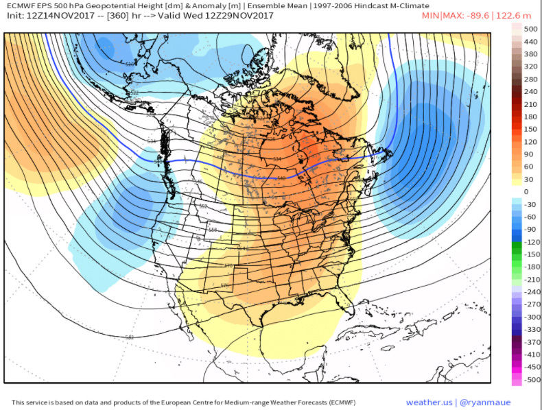
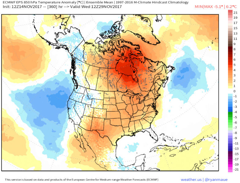
As the beyond there, I am not encouraged by the latest EPS. The end of the run shows warm air flowing in from the midwest to the East:
500 mb height anomalies:
850 mb temp anomalies:
2-meter temp anomalies:

Notice by the way that it uses the 1997-2016 anomalies rather than 1981-2010 that the NWS uses. If you replaced it with 1981-2010, the anomalies would be higher.
I know December is still over two weeks out but I am not encouraged by how December looks at this point.
Math23x7- Wx Statistician Guru

- Posts : 2379
Reputation : 68
Join date : 2013-01-08
Re: Long Range Thread 15.0
![]() by algae888 Tue Nov 14, 2017 4:53 pm
by algae888 Tue Nov 14, 2017 4:53 pm
mike why are you cherry picking warm guidance.since you are using a 360 hour forecast take a look at the euro weeklies weeks 4 thru 6. roughly dec 2nd to around xmas. tell me what you see. week three on the weeklies ( week after t day) was always a relaxation from this very cold spell then reload.that's what your seeing on guidance. tell the whole story man. it's cold thru t day weekend. probably -4* by that time. that's a HUGE pattern shift!! plus it has been very active. man you have become a Debbie downer.Math23x7 wrote:So the pattern the next couple of weeks looks to be cold-cuts. In other words, It will be cold and dry except when we have a cutter, in which case we get warm precipitation with temps in the 50s and 60s. When those cutters pass, the temperatures drop.
As the beyond there, I am not encouraged by the latest EPS. The end of the run shows warm air flowing in from the midwest to the East:
500 mb height anomalies:
850 mb temp anomalies:
2-meter temp anomalies:
Notice by the way that it uses the 1997-2016 anomalies rather than 1981-2010 that the NWS uses. If you replaced it with 1981-2010, the anomalies would be higher.
I know December is still over two weeks out but I am not encouraged by how December looks at this point.
algae888- Advanced Forecaster
- Posts : 5311
Reputation : 46
Join date : 2013-02-05
Age : 61
Location : mt. vernon, new york
Re: Long Range Thread 15.0
![]() by algae888 Tue Nov 14, 2017 5:04 pm
by algae888 Tue Nov 14, 2017 5:04 pm
"Looks like PAC is trying to begin a reload a bit more than last night's run. You can see the plains heights lower and the heights near and N of AK higher at the end of the run vs the 00z run. It would probably look better if we had a few more frames out to about day 17 or 18.
That kind of agrees with yesterdays weeklies where we saw the reload happening in week 3 and then week 4 was looking pretty good. So hopefully we continue to see that progression....that would be good timing as climo would be a lot more favorable by that point."
algae888- Advanced Forecaster
- Posts : 5311
Reputation : 46
Join date : 2013-02-05
Age : 61
Location : mt. vernon, new york
Re: Long Range Thread 15.0
![]() by algae888 Tue Nov 14, 2017 5:32 pm
by algae888 Tue Nov 14, 2017 5:32 pm
"The fact that November will likely come in BN and the composite of the month will have good N PAC poleward Aleutian ridging is definitely a good sign going into December. It suggests that any relaxation of the PAC will probably be short lived."
algae888- Advanced Forecaster
- Posts : 5311
Reputation : 46
Join date : 2013-02-05
Age : 61
Location : mt. vernon, new york
Re: Long Range Thread 15.0
![]() by Frank_Wx Wed Nov 15, 2017 8:15 am
by Frank_Wx Wed Nov 15, 2017 8:15 am

_________________
_______________________________________________________________________________________________________
CLICK HERE to view NJ Strong Snowstorm Classifications
Frank_Wx- Godzilla Seeker
- Posts : 21305
Reputation : 328
Join date : 2013-01-05
Age : 31
Location : Jersey City, NJ -
Re: Long Range Thread 15.0
![]() by Frank_Wx Wed Nov 15, 2017 8:17 am
by Frank_Wx Wed Nov 15, 2017 8:17 am

_________________
_______________________________________________________________________________________________________
CLICK HERE to view NJ Strong Snowstorm Classifications
Frank_Wx- Godzilla Seeker
- Posts : 21305
Reputation : 328
Join date : 2013-01-05
Age : 31
Location : Jersey City, NJ -
Re: Long Range Thread 15.0
![]() by sroc4 Wed Nov 15, 2017 8:56 am
by sroc4 Wed Nov 15, 2017 8:56 am
Frank_Wx wrote:A coastal storm is showing up on the models for Thanksgiving Day but it's looking to warm for any snow at this time. Since it's still a week away there is time for change. They key is the northern piece. At the moment, the GFS shows it closing off over the Great Lakes which raises heights along the east coast. We want this northern piece to dig downstream in response to the PNA ridge and phase with a southern piece of energy off our coast. That would ensure cold air is in place. Plenty of time for this to happen still.
Yeah it is setting up to be a Miller B type set up which this early in the season will def be extremely tough to have work out along the coastal plain. Like you said still a ways out and the final soln rarely shows itself definitively this far out.
Frank whats the actual difference between a wave 1, wave 2, and wave 3 attack on the stratosphere? Is it strictly the geographic location for which the attack occurs?
_________________
"In weather and in life, there's no winning and losing; there's only winning and learning."
WINTER 2012/2013 TOTALS 43.65"WINTER 2017/2018 TOTALS 62.85" WINTER 2022/2023 TOTALS 4.9"
WINTER 2013/2014 TOTALS 64.85"WINTER 2018/2019 TOTALS 14.25" WINTER 2023/2024 TOTALS 13.1"
WINTER 2014/2015 TOTALS 71.20"WINTER 2019/2020 TOTALS 6.35"
WINTER 2015/2016 TOTALS 35.00"WINTER 2020/2021 TOTALS 37.75"
WINTER 2016/2017 TOTALS 42.25"WINTER 2021/2022 TOTALS 31.65"
sroc4- Admin
- Posts : 8331
Reputation : 301
Join date : 2013-01-07
Location : Wading River, LI
Re: Long Range Thread 15.0
![]() by algae888 Wed Nov 15, 2017 10:09 am
by algae888 Wed Nov 15, 2017 10:09 am

algae888- Advanced Forecaster
- Posts : 5311
Reputation : 46
Join date : 2013-02-05
Age : 61
Location : mt. vernon, new york
Re: Long Range Thread 15.0
![]() by algae888 Wed Nov 15, 2017 10:17 am
by algae888 Wed Nov 15, 2017 10:17 am
euro


gfs


with the west based block and 50/50 low it makes sense for the next s/w/trough to dig into U.S. heartland. it should not move east. let's see if there is a correction on the next few runs of euro.
algae888- Advanced Forecaster
- Posts : 5311
Reputation : 46
Join date : 2013-02-05
Age : 61
Location : mt. vernon, new york
Re: Long Range Thread 15.0
![]() by sroc4 Wed Nov 15, 2017 1:44 pm
by sroc4 Wed Nov 15, 2017 1:44 pm
algae888 wrote:more on euro. my question is how does the trough over central Canada move east instead of dropping into central U.S.. look at the dif. between euro and gfs....
euro
gfs
with the west based block and 50/50 low it makes sense for the next s/w/trough to dig into U.S. heartland. it should not move east. let's see if there is a correction on the next few runs of euro.
There are a couple of differences Al. First is the GFS has the northern stream energy a little stronger vs the euro. The second and more significant is the interaction and placement of the southern piece of energy. Here are the GFS and euro and you can see by 00z the 21st look at the difference in position and amt of interaction the GFS vs the euro has. The GFS clearly has much more interaction between the N and S pieces by this time because the S piece is much further east when compared to the euro. This allows the PNA ridge to be a little taller which allows the N piece to dig a little more and interact with the southern branch.

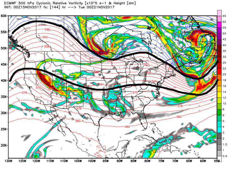
The result is a much stronger system that cuts. The euro on the other hand holds back the energy in the west (a known bias) therefore the N piece doesnt dig and interact nearly as much resulting in a Low that passes N and W and the two branches remaining unphased for the most part. Honestly we need to have the southern energy to slight out ahead of the N energy rather than the reverse like the GFS shows where its just behind. The way its currently modeled by both models will result in warm out ahead of the cutter followed by cold frontal passage and below normal behind the front.

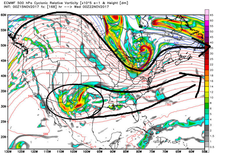
Of course 12z GFS has a COMPLETELY different look compared to the 6z meaning dont trust it. Euro has been consistent at least with holding back the energy.


_________________
"In weather and in life, there's no winning and losing; there's only winning and learning."
WINTER 2012/2013 TOTALS 43.65"WINTER 2017/2018 TOTALS 62.85" WINTER 2022/2023 TOTALS 4.9"
WINTER 2013/2014 TOTALS 64.85"WINTER 2018/2019 TOTALS 14.25" WINTER 2023/2024 TOTALS 13.1"
WINTER 2014/2015 TOTALS 71.20"WINTER 2019/2020 TOTALS 6.35"
WINTER 2015/2016 TOTALS 35.00"WINTER 2020/2021 TOTALS 37.75"
WINTER 2016/2017 TOTALS 42.25"WINTER 2021/2022 TOTALS 31.65"
sroc4- Admin
- Posts : 8331
Reputation : 301
Join date : 2013-01-07
Location : Wading River, LI
Re: Long Range Thread 15.0
![]() by amugs Wed Nov 15, 2017 8:18 pm
by amugs Wed Nov 15, 2017 8:18 pm
Sitting tight and Al just know you are the third person here to call Miey Math23x7 out about the warmth. Heat Miser??
Anyway , like the polar extension from the top pac and we have a warming in the PV that will perturbation it for latter Nov and early Dec. Where it sets up on the side of the world will be important. To far weat and it opens up the SE Ridge to a degree for the coast. Set up in Alberta and good location to a degree. Beat is HB west shore.
Good discussion here lads and keep it up. Lots of changed coming with the transition.
_________________
Mugs
AKA:King: Snow Weenie
Self Proclaimed
WINTER 2014-15 : 55.12" +.02 for 6 coatings (avg. 35")
WINTER 2015-16 Total - 29.8" (Avg 35")
WINTER 2016-17 : 39.5" so far

amugs- Advanced Forecaster - Mod

- Posts : 15093
Reputation : 213
Join date : 2013-01-07
Age : 54
Location : Hillsdale,NJ
Re: Long Range Thread 15.0
![]() by sroc4 Wed Nov 15, 2017 9:04 pm
by sroc4 Wed Nov 15, 2017 9:04 pm
_________________
"In weather and in life, there's no winning and losing; there's only winning and learning."
WINTER 2012/2013 TOTALS 43.65"WINTER 2017/2018 TOTALS 62.85" WINTER 2022/2023 TOTALS 4.9"
WINTER 2013/2014 TOTALS 64.85"WINTER 2018/2019 TOTALS 14.25" WINTER 2023/2024 TOTALS 13.1"
WINTER 2014/2015 TOTALS 71.20"WINTER 2019/2020 TOTALS 6.35"
WINTER 2015/2016 TOTALS 35.00"WINTER 2020/2021 TOTALS 37.75"
WINTER 2016/2017 TOTALS 42.25"WINTER 2021/2022 TOTALS 31.65"
sroc4- Admin
- Posts : 8331
Reputation : 301
Join date : 2013-01-07
Location : Wading River, LI
Re: Long Range Thread 15.0
![]() by Isotherm Thu Nov 16, 2017 9:36 am
by Isotherm Thu Nov 16, 2017 9:36 am
Isotherm- Advanced Forecaster
- Posts : 231
Reputation : 4
Join date : 2014-09-01
Age : 33
Location : Monmouth County, NJ -
Re: Long Range Thread 15.0
![]() by sroc4 Thu Nov 16, 2017 9:51 am
by sroc4 Thu Nov 16, 2017 9:51 am
Isotherm wrote:Previous w2 hit now transitioning into a largely suppressed vertical wave driving regime for the upcoming 7 days, as the strengthening PNJ / SPV will project onto the troposphere by D7-10 with a neutralization of the NAM. However, a robust w1 constructive interference will occur D10-15 which will converge on the vortex by the end of this month, resulting in about a 40-45% (or potentially more) reduction in mean zonal winds at 10hpa. I expect these effects to downwell one week following, bringing us to late in the first week of December or the second week. By that point, a contemporaneous shift in low-frequency tropical forcing will once again initiate Aleutian ridging, coupled w/ an increase in hi-lat blocking. So I do expect this transitional phase to in fact be a legitimate "relaxation," preceding a more auspicious pattern henceforth.
Tom what's the actual difference between a wave 1, wave 2, and wave 3 attack on the stratosphere? Is it strictly the geographic location for which the attack/EPV flux occurs?
_________________
"In weather and in life, there's no winning and losing; there's only winning and learning."
WINTER 2012/2013 TOTALS 43.65"WINTER 2017/2018 TOTALS 62.85" WINTER 2022/2023 TOTALS 4.9"
WINTER 2013/2014 TOTALS 64.85"WINTER 2018/2019 TOTALS 14.25" WINTER 2023/2024 TOTALS 13.1"
WINTER 2014/2015 TOTALS 71.20"WINTER 2019/2020 TOTALS 6.35"
WINTER 2015/2016 TOTALS 35.00"WINTER 2020/2021 TOTALS 37.75"
WINTER 2016/2017 TOTALS 42.25"WINTER 2021/2022 TOTALS 31.65"
sroc4- Admin
- Posts : 8331
Reputation : 301
Join date : 2013-01-07
Location : Wading River, LI
Re: Long Range Thread 15.0
![]() by GreyBeard Thu Nov 16, 2017 1:12 pm
by GreyBeard Thu Nov 16, 2017 1:12 pm
Isotherm wrote:Previous w2 hit now transitioning into a largely suppressed vertical wave driving regime for the upcoming 7 days, as the strengthening PNJ / SPV will project onto the troposphere by D7-10 with a neutralization of the NAM. However, a robust w1 constructive interference will occur D10-15 which will converge on the vortex by the end of this month, resulting in about a 40-45% (or potentially more) reduction in mean zonal winds at 10hpa. I expect these effects to downwell one week following, bringing us to late in the first week of December or the second week. By that point, a contemporaneous shift in low-frequency tropical forcing will once again initiate Aleutian ridging, coupled w/ an increase in hi-lat blocking. So I do expect this transitional phase to in fact be a legitimate "relaxation," preceding a more auspicious pattern henceforth.
Trying to read your posts is like trying to read a foreign language. Perhaps you can say what you want to say in terms that the average reader can understand. I, for one, haven't a clue.
GreyBeard- Senior Enthusiast
- Posts : 725
Reputation : 34
Join date : 2014-02-12
Location : eastern nassau county
Re: Long Range Thread 15.0
![]() by sroc4 Thu Nov 16, 2017 2:18 pm
by sroc4 Thu Nov 16, 2017 2:18 pm
GreyBeard wrote:Isotherm wrote:Previous w2 hit now transitioning into a largely suppressed vertical wave driving regime for the upcoming 7 days, as the strengthening PNJ / SPV will project onto the troposphere by D7-10 with a neutralization of the NAM. However, a robust w1 constructive interference will occur D10-15 which will converge on the vortex by the end of this month, resulting in about a 40-45% (or potentially more) reduction in mean zonal winds at 10hpa. I expect these effects to downwell one week following, bringing us to late in the first week of December or the second week. By that point, a contemporaneous shift in low-frequency tropical forcing will once again initiate Aleutian ridging, coupled w/ an increase in hi-lat blocking. So I do expect this transitional phase to in fact be a legitimate "relaxation," preceding a more auspicious pattern henceforth.
Trying to read your posts is like trying to read a foreign language. Perhaps you can say what you want to say in terms that the average reader can understand. I, for one, haven't a clue.
Simply stated a wave 1(w1) attack on the stratospheric vortex initiated by the very potent MJO wave we saw the last 10days of Oct combined with two recurving typhoons in the same timeframe caused a disruption to the strat vortex such that it was weakened and became elongated and even split for a brief time and positioned on our side of the globe which led to the establishment of high latitude blocking (WPO/EPO regions) over the Aleutian islands and Alaska extending into the arctic. The result of this positioning of the strat vortex on the north american side of the N hemisphere elongated as such, and the resultant high lat blocking set up in the WPO/EPO region (Aleutian Island/Alaska) allowed the cold air to be discharged into the mid latitudes of north America. The arctic blast we saw around the 7-9th and the below normal temps since then were the result of that.
A wave 2 attack on the strat vortex (w2) occurred in the first 5-7days of November which is leading to additional disruption to the strat vortex such that high latitude blocking in the north Atlantic(NAO) region is becoming established. However, we may be losing the high lat blocking in the Aleutian Island/alaska location while simultaneously establishing the blocking in the N Atlantic/Greenland location.
There will likely be a relaxing period after the Thanksgiving through the first to second week of December, aka a loss of high lat blocking in the N Atlantic AND/OR N Pac, and the strat will likely get stronger for a period, tighten up, and shift away from north America and possibly onto the Asian side of the N Hemisphere for a period. This will likely result in a period of a couple of weeks that will go back to warmer than normal temps overall for most of us...
BUT he believes a strong wave 1(w1) attack is imminent on the strat vortex once again in the 10-15 day time frame, the result of which will lead to the distruption/weakening of the strat vortex once again such that the high latitude blocking in the troposphere(where we live) re-establishing itself around the Aluetian Islands once again which will hopefully discharge the cold air into the mid latitudes of north America (our back yards) for the later half of December.
Last edited by sroc4 on Thu Nov 16, 2017 6:28 pm; edited 1 time in total
_________________
"In weather and in life, there's no winning and losing; there's only winning and learning."
WINTER 2012/2013 TOTALS 43.65"WINTER 2017/2018 TOTALS 62.85" WINTER 2022/2023 TOTALS 4.9"
WINTER 2013/2014 TOTALS 64.85"WINTER 2018/2019 TOTALS 14.25" WINTER 2023/2024 TOTALS 13.1"
WINTER 2014/2015 TOTALS 71.20"WINTER 2019/2020 TOTALS 6.35"
WINTER 2015/2016 TOTALS 35.00"WINTER 2020/2021 TOTALS 37.75"
WINTER 2016/2017 TOTALS 42.25"WINTER 2021/2022 TOTALS 31.65"
sroc4- Admin
- Posts : 8331
Reputation : 301
Join date : 2013-01-07
Location : Wading River, LI
Re: Long Range Thread 15.0
![]() by sroc4 Thu Nov 16, 2017 2:21 pm
by sroc4 Thu Nov 16, 2017 2:21 pm
We will likely cont below normal to normal temps between now and Thanksgiving. After that time there is a good chance, but not definite that we go to above normal to maybe normal temps for a period of about two weeks +/-. Beyond that we may go back to below normal temp regime for the latter half of the month of Dec.
_________________
"In weather and in life, there's no winning and losing; there's only winning and learning."
WINTER 2012/2013 TOTALS 43.65"WINTER 2017/2018 TOTALS 62.85" WINTER 2022/2023 TOTALS 4.9"
WINTER 2013/2014 TOTALS 64.85"WINTER 2018/2019 TOTALS 14.25" WINTER 2023/2024 TOTALS 13.1"
WINTER 2014/2015 TOTALS 71.20"WINTER 2019/2020 TOTALS 6.35"
WINTER 2015/2016 TOTALS 35.00"WINTER 2020/2021 TOTALS 37.75"
WINTER 2016/2017 TOTALS 42.25"WINTER 2021/2022 TOTALS 31.65"
sroc4- Admin
- Posts : 8331
Reputation : 301
Join date : 2013-01-07
Location : Wading River, LI
Page 8 of 42 • 1 ... 5 ... 7, 8, 9 ... 25 ... 42 ![]()
|
|
|