Long Range Thread 15.0
+41
jake732
New Yorker 234
Ltd
devsman
jimv45
bobjohnsonforthehall
SnowForest
Wheezer
oldtimer
Armando Salvadore
mmanisca
track17
lglickman1
Sanchize06
mikeypizano
Dunnzoo
hyde345
SENJsnowman
skinsfan1177
MattyICE
GreyBeard
aiannone
Radz
Math23x7
Snow88
docstox12
frank 638
rb924119
HectorO
jmanley32
algae888
CPcantmeasuresnow
dkodgis
Isotherm
weatherwatchermom
sroc4
nutleyblizzard
amugs
RJB8525
billg315
Frank_Wx
45 posters
Page 42 of 42
Page 42 of 42 •  1 ... 22 ... 40, 41, 42
 Re: Long Range Thread 15.0
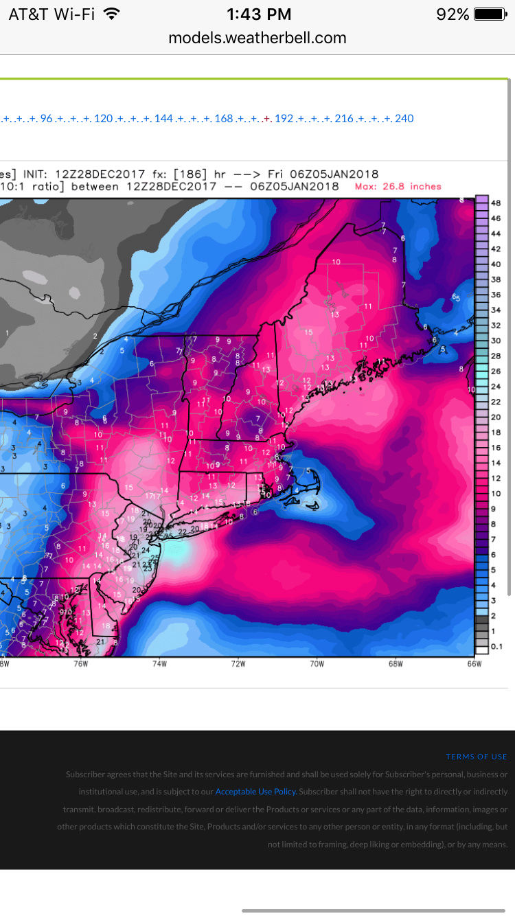
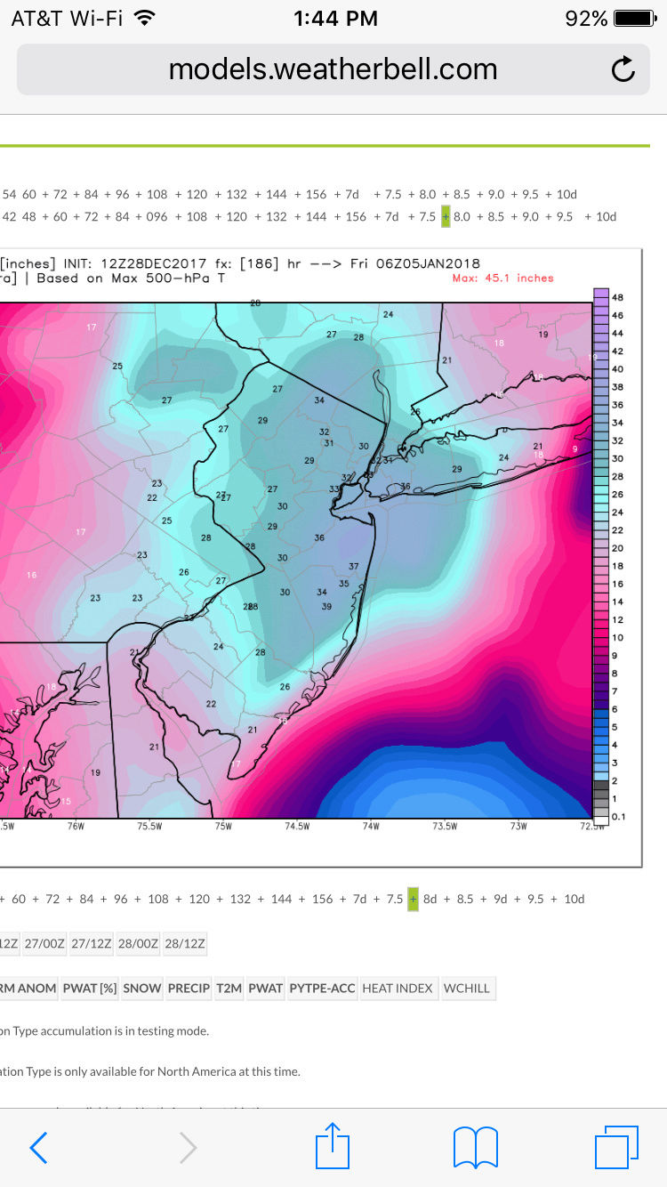
This run has a very strong similarity to Feb 22-26 2010
rb924119- Meteorologist

- Posts : 6928
Join date : 2013-02-06
 Re: Long Range Thread 15.0
boy with ratios that's 2 feet plus for area!! sign me up.
jimv45- Senior Enthusiast

- Posts : 1168
Join date : 2013-09-20
 Re: Long Range Thread 15.0
Haha everyone stay calm. Lucy pulled the football from under us right before we kicked off this weekends storm with a similar look 7 days out lol.

crippo84- Posts : 383
Reputation : 20
Join date : 2013-11-07
Age : 40
Location : East Village, NYC
 Re: Long Range Thread 15.0
God we should archive these pictures so every time we get shafted we can look back and dream ahaha it doesn't get any better than this for the East Coast. I wish this was seven hours out, not days :/ too many things can still go wrong.
rb924119- Meteorologist

- Posts : 6928
Reputation : 194
Join date : 2013-02-06
Age : 32
Location : Greentown, Pa
 Re: Long Range Thread 15.0
rb924119 wrote:10:1
Ratios:
Well, those two are KOD worthy for my area.I'll expect a coating to an inch from this one like the 40 inch one that was supposed to hit on Saturday,LOL.Sorry, I'm not being sarcastic, just busting chops rb, you are the best and thanks for posting these.

docstox12- Wx Statistician Guru

- Posts : 8530
Reputation : 222
Join date : 2013-01-07
Age : 73
Location : Monroe NY
 Re: Long Range Thread 15.0
rb924119 wrote:God we should archive these pictures so every time we get shafted we can look back and dream ahaha it doesn't get any better than this for the East Coast. I wish this was seven hours out, not days :/ too many things can still go wrong.
Geez I said less than two hours ago I'm glad we're not in the bullseye 7 days out because that's always the KOD, unfortunately we are now in the bullseye.

CPcantmeasuresnow- Wx Statistician Guru

- Posts : 7274
Reputation : 230
Join date : 2013-01-07
Age : 103
Location : Eastern Orange County, NY
 Re: Long Range Thread 15.0
The one thing that is going with this threat is there are no shortwave kickers crashing into the west coast this time around. That should keep any progressive nature of the pattern at bay.rb924119 wrote:God we should archive these pictures so every time we get shafted we can look back and dream ahaha it doesn't get any better than this for the East Coast. I wish this was seven hours out, not days :/ too many things can still go wrong.

nutleyblizzard- Senior Enthusiast

- Posts : 1954
Reputation : 41
Join date : 2014-01-30
Age : 58
Location : Nutley, new jersey
 Re: Long Range Thread 15.0
rb924119 wrote:God we should archive these pictures so every time we get shafted we can look back and dream ahaha it doesn't get any better than this for the East Coast. I wish this was seven hours out, not days :/ too many things can still go wrong.
This. A week ago we were hootin' and hollerin' about this weekend's "big one." I don't have faith outside of 24-48 hrs anymore tbh. The eleventh-hour surprises are always fun too (a la Boxing Day).

SoulSingMG- Senior Enthusiast

- Posts : 2853
Reputation : 74
Join date : 2013-12-11
Location : Long Island City, NY
 Re: Long Range Thread 15.0
NOOOOOOOOOOOOOOO the jinx of the snow maps this far out ARRGHHHHHHH!!
_________________
Mugs
AKA:King: Snow Weenie
Self Proclaimed
WINTER 2014-15 : 55.12" +.02 for 6 coatings (avg. 35")
WINTER 2015-16 Total - 29.8" (Avg 35")
WINTER 2016-17 : 39.5" so far

amugs- Advanced Forecaster - Mod

- Posts : 15095
Reputation : 213
Join date : 2013-01-07
Age : 54
Location : Hillsdale,NJ
 Re: Long Range Thread 15.0
Ok lets try this. It worked for the March blizzard...
WE'RE NOT GOING TO GET TWO FEET!!!
WE'RE NOT GOING TO GET TWO FEET!!!

mikeypizano- Pro Enthusiast

- Posts : 1118
Reputation : 66
Join date : 2017-01-05
Age : 35
Location : Wilkes-Barre/Scranton, PA
 Re: Long Range Thread 15.0
nutleyblizzard wrote:The one thing that is going with this threat is there are no shortwave kickers crashing into the west coast this time around. That should keep any progressive nature of the pattern at bay.rb924119 wrote:God we should archive these pictures so every time we get shafted we can look back and dream ahaha it doesn't get any better than this for the East Coast. I wish this was seven hours out, not days :/ too many things can still go wrong.
There weren't with the one for this weekend and we see how that worked out. I'm still worried about the Pac simply because of the jet extension resulting in the same issue we saw evolve for this weekend, but also the Atlantic with a transient 50/50 low and wave spacing.
rb924119- Meteorologist

- Posts : 6928
Reputation : 194
Join date : 2013-02-06
Age : 32
Location : Greentown, Pa
 Re: Long Range Thread 15.0
Jesus just when I was get over this weekend the euro has to go nuts again. Just have wait and see what happens.

jmanley32- Senior Enthusiast

- Posts : 20535
Reputation : 108
Join date : 2013-12-12
Age : 43
Location : Yonkers, NY
 Re: Long Range Thread 15.0
Okay originates from Fla and runs teh coast with a 50/50 LP and HP as well as it shift NE towards Greenland - we need this earlier than later for this to produce a big storm (ala NESIS type, KU one) Without this help the nina jet is wayyyyy to fast to support this as we have this weekend. The PNA is a plus and YUUGE BUT without some Atlantic help many will be at the ledge.


And look at the WPO, EPO and PNA - holy crap they are on roids here - warm up postponed - it will come but not sooner than later IF again IF this comes to fruition and the cold arctic air this storm as depicted pulls in behind it will rival what we are in now!!


And look at the WPO, EPO and PNA - holy crap they are on roids here - warm up postponed - it will come but not sooner than later IF again IF this comes to fruition and the cold arctic air this storm as depicted pulls in behind it will rival what we are in now!!

_________________
Mugs
AKA:King: Snow Weenie
Self Proclaimed
WINTER 2014-15 : 55.12" +.02 for 6 coatings (avg. 35")
WINTER 2015-16 Total - 29.8" (Avg 35")
WINTER 2016-17 : 39.5" so far

amugs- Advanced Forecaster - Mod

- Posts : 15095
Reputation : 213
Join date : 2013-01-07
Age : 54
Location : Hillsdale,NJ
 Re: Long Range Thread 15.0
If we dont get the timeframe of 3/4th and it is pushed back we run the risk of a coastal hugger and we go from Nina type storm of front end dump, ice to rain to backend snow.
_________________
Mugs
AKA:King: Snow Weenie
Self Proclaimed
WINTER 2014-15 : 55.12" +.02 for 6 coatings (avg. 35")
WINTER 2015-16 Total - 29.8" (Avg 35")
WINTER 2016-17 : 39.5" so far

amugs- Advanced Forecaster - Mod

- Posts : 15095
Reputation : 213
Join date : 2013-01-07
Age : 54
Location : Hillsdale,NJ
 Re: Long Range Thread 15.0
SoulSingMG wrote:rb924119 wrote:God we should archive these pictures so every time we get shafted we can look back and dream ahaha it doesn't get any better than this for the East Coast. I wish this was seven hours out, not days :/ too many things can still go wrong.
This. A week ago we were hootin' and hollerin' about this weekend's "big one." I don't have faith outside of 24-48 hrs anymore tbh. The eleventh-hour surprises are always fun too (a la Boxing Day).
BINGO!!! I had said a few days ago I would see what is on the board for THURSDAY, and sure enough, this fizzled into MAYBE an inch or two.It is a lot of fun to see these outrageous maps a week out but I will not believe any of that until a day or two before the event.I would much rather have what somebody just said a Boxing Day Blizzard scenario.OTS or 1 to 3 inches 3 or 4 days before, and then see the day before B Word red on all the NWS maps with 20 plus inches on the way confirmed by radar on the day of the storm.

docstox12- Wx Statistician Guru

- Posts : 8530
Reputation : 222
Join date : 2013-01-07
Age : 73
Location : Monroe NY
 Re: Long Range Thread 15.0
From another board - closed low in this position just buries us


_________________
Mugs
AKA:King: Snow Weenie
Self Proclaimed
WINTER 2014-15 : 55.12" +.02 for 6 coatings (avg. 35")
WINTER 2015-16 Total - 29.8" (Avg 35")
WINTER 2016-17 : 39.5" so far

amugs- Advanced Forecaster - Mod

- Posts : 15095
Reputation : 213
Join date : 2013-01-07
Age : 54
Location : Hillsdale,NJ
 Re: Long Range Thread 15.0
amugs wrote:If we dont get the timeframe of 3/4th and it is pushed back we run the risk of a coastal hugger and we go from Nina type storm of front end dump, ice to rain to backend snow.
Given the EURO suite verbatim (assuming it is correct which is dicey at best right now), I would expect a track inside the BM and near a coastal hugger type of track given its depiction of the whole pattern. But that's a huge assumption, and purely conjecture at this point.
rb924119- Meteorologist

- Posts : 6928
Reputation : 194
Join date : 2013-02-06
Age : 32
Location : Greentown, Pa
 Re: Long Range Thread 15.0
if it wasn't just about a week away i'd buy it...need to see the GFS get into this not just it loving Red Sox Suck

RJB8525- Senior Enthusiast

- Posts : 1994
Reputation : 28
Join date : 2013-02-06
Age : 38
Location : Hackettstown, NJ
 Re: Long Range Thread 15.0
New long range thread started.
_________________
_______________________________________________________________________________________________________
CLICK HERE to view NJ Strong Snowstorm Classifications
Page 42 of 42 •  1 ... 22 ... 40, 41, 42
Page 42 of 42
Permissions in this forum:
You cannot reply to topics in this forum|
|
|

 Home
Home

