
 Search
Long Range Thread 16.0
Page 33 of 40 •  1 ... 18 ... 32, 33, 34 ... 36 ... 40
 ![]()
Re: Long Range Thread 16.0
![]() by Math23x7 Sat Jan 27, 2018 1:53 am
by Math23x7 Sat Jan 27, 2018 1:53 am
Math23x7- Wx Statistician Guru

- Posts : 2379
Join date : 2013-01-08
Re: Long Range Thread 16.0
![]() by sroc4 Sat Jan 27, 2018 7:32 am
by sroc4 Sat Jan 27, 2018 7:32 am
sroc4- Admin

- Posts : 8331
Join date : 2013-01-07
Re: Long Range Thread 16.0
![]() by RJB8525 Sat Jan 27, 2018 10:39 am
by RJB8525 Sat Jan 27, 2018 10:39 am

RJB8525- Senior Enthusiast

- Posts : 1994
Reputation : 28
Join date : 2013-02-06
Age : 38
Location : Hackettstown, NJ
Re: Long Range Thread 16.0
![]() by skinsfan1177 Sat Jan 27, 2018 1:35 pm
by skinsfan1177 Sat Jan 27, 2018 1:35 pm


skinsfan1177- Senior Enthusiast
- Posts : 4485
Reputation : 35
Join date : 2013-01-07
Age : 46
Location : Point Pleasant Boro

skinsfan1177- Senior Enthusiast
- Posts : 4485
Reputation : 35
Join date : 2013-01-07
Age : 46
Location : Point Pleasant Boro
Re: Long Range Thread 16.0
![]() by sroc4 Sun Jan 28, 2018 8:24 am
by sroc4 Sun Jan 28, 2018 8:24 am
skinsfan1177 wrote:Euro looks decent
EPS
_________________
"In weather and in life, there's no winning and losing; there's only winning and learning."
WINTER 2012/2013 TOTALS 43.65"WINTER 2017/2018 TOTALS 62.85" WINTER 2022/2023 TOTALS 4.9"
WINTER 2013/2014 TOTALS 64.85"WINTER 2018/2019 TOTALS 14.25" WINTER 2023/2024 TOTALS 13.1"
WINTER 2014/2015 TOTALS 71.20"WINTER 2019/2020 TOTALS 6.35"
WINTER 2015/2016 TOTALS 35.00"WINTER 2020/2021 TOTALS 37.75"
WINTER 2016/2017 TOTALS 42.25"WINTER 2021/2022 TOTALS 31.65"

sroc4- Admin
- Posts : 8331
Reputation : 301
Join date : 2013-01-07
Location : Wading River, LI
Re: Long Range Thread 16.0
![]() by Guest Sun Jan 28, 2018 9:24 am
by Guest Sun Jan 28, 2018 9:24 am
Guest- Guest
Re: Long Range Thread 16.0
![]() by docstox12 Sun Jan 28, 2018 9:53 am
by docstox12 Sun Jan 28, 2018 9:53 am
syosnow94 wrote:Not gonna lie Scott, I would like to see those EPS members a bit more s and e. I think over half of them are too close for us on the coast with a marginally cold airmass in place.
Sorry, Jimmy, I'm pulling for a more N and W trend!NWS has me all snow now, there was a rain/snow mix at the beginning.60% chance now at night.

docstox12- Wx Statistician Guru
- Posts : 8507
Reputation : 222
Join date : 2013-01-07
Age : 73
Location : Monroe NY
Re: Long Range Thread 16.0
![]() by CPcantmeasuresnow Sun Jan 28, 2018 10:11 am
by CPcantmeasuresnow Sun Jan 28, 2018 10:11 am
docstox12 wrote:syosnow94 wrote:Not gonna lie Scott, I would like to see those EPS members a bit more s and e. I think over half of them are too close for us on the coast with a marginally cold airmass in place.
Sorry, Jimmy, I'm pulling for a more N and W trend!NWS has me all snow now, there was a rain/snow mix at the beginning.60% chance now at night.
Not surprisingly I couldn't agree more Doc, tuck that sucker inside the BM.

CPcantmeasuresnow- Wx Statistician Guru
- Posts : 7274
Reputation : 230
Join date : 2013-01-07
Age : 103
Location : Eastern Orange County, NY
Re: Long Range Thread 16.0
![]() by sroc4 Sun Jan 28, 2018 11:02 am
by sroc4 Sun Jan 28, 2018 11:02 am
syosnow94 wrote:Not gonna lie Scott, I would like to see those EPS members a bit more s and e. I think over half of them are too close for us on the coast with a marginally cold airmass in place.
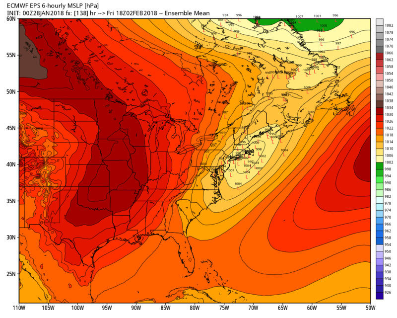
With the continued evolution of the cold suppressing the warmth leading into this time frame this is exactly where we want this to be 5-6days out in the means. That said it is entirely possible we start as rain or mix along the coast, but change over to snow. In this type for set up and pattern, -EPO driving arctic air S&E, I expect the trends over time to continue to bring the arctic boundary further south at least a little. I actually like where the LP placement is on the euro op right now. There is a huge difference with this set up than say the one for tomorrow into Tuesday even though there are some similarities.
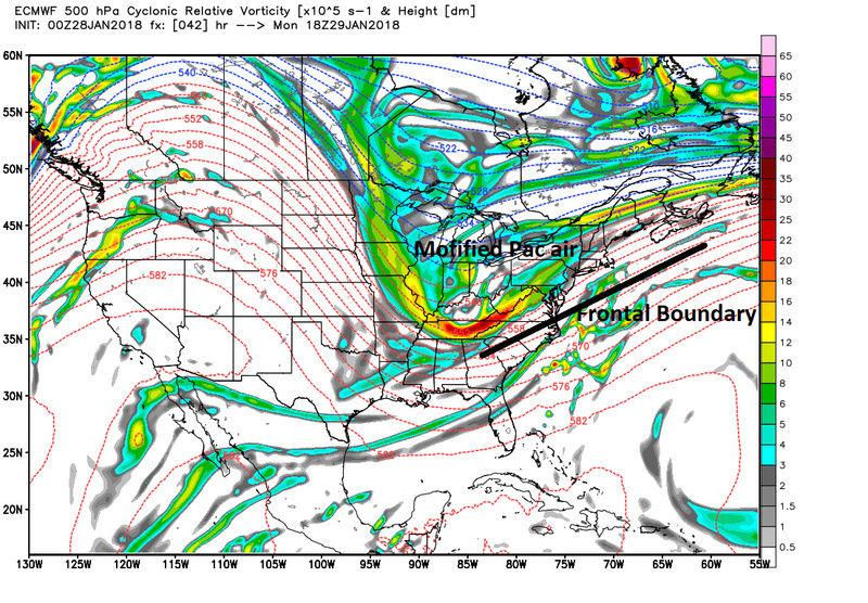
Similar in a sense that the rain and warmth we are experiencing today is via a frontal boundary pushing S&E through the area followed by a secondary wave of LP developing along the frontal boundary associated with northern stream energy rounding the incoming trough. A similar evolution in a general sense for the 2nd 3rd set up in that a LP will develop along a stalled frontal boundary that passes S&E of our region Wed Thursday this week; however there is a huge difference in that the air masses for which the wave of LP developing has to work with.
The air mass to our north for Monday night to Tuesday in reality is modified Pac air.
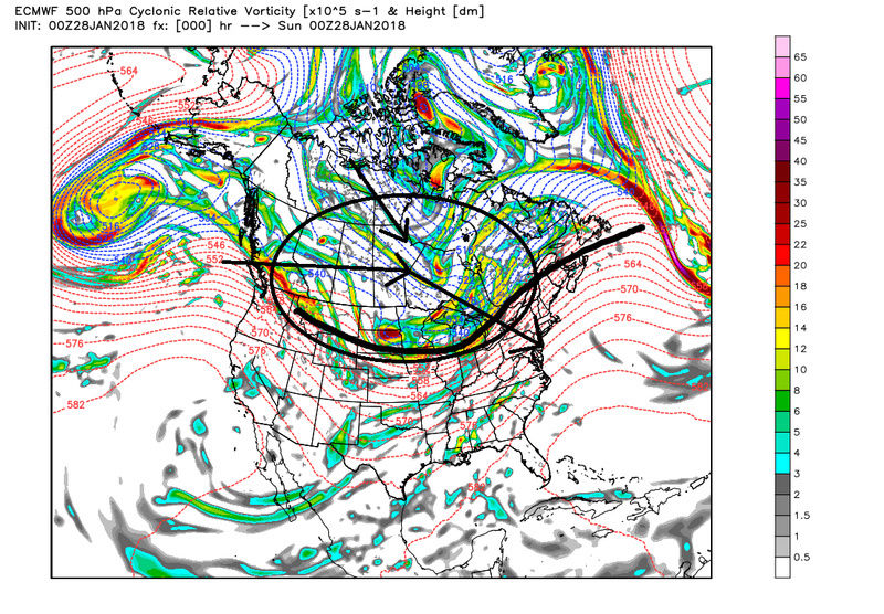
However as we head into Feb a spike in the ridging just off the WC of the CONUS and WC of Canada in response to a trough developing S off the Aleutian Islands is driving a polar air mass mixed with arctic origins S&E such that after the front passes the air mass sitting to our north will be much colder and much denser and hence will have an easier time beating back the warmer air.

A very similar type set up can go back to March 2013/14 when we had a strong -EPO driving one cold Canadian HP after another S&E through Canada into the Central plains and NE CONUS with weak waves of LP over performing along the EC due to enhancement from a very tight thermal gradient, aka baroclinic zone, enhancing lift. Take a look at the temp anomalies the surface LP has to work with for the Mon/Tues system vs the 2nd 3rd system. Clearly the air masses will be different.


Nothing is set in stone just yet. areas just off the coast stand to do the best with this system but the coastal plain is Definitely still in the game for this one.
_________________
"In weather and in life, there's no winning and losing; there's only winning and learning."
WINTER 2012/2013 TOTALS 43.65"WINTER 2017/2018 TOTALS 62.85" WINTER 2022/2023 TOTALS 4.9"
WINTER 2013/2014 TOTALS 64.85"WINTER 2018/2019 TOTALS 14.25" WINTER 2023/2024 TOTALS 13.1"
WINTER 2014/2015 TOTALS 71.20"WINTER 2019/2020 TOTALS 6.35"
WINTER 2015/2016 TOTALS 35.00"WINTER 2020/2021 TOTALS 37.75"
WINTER 2016/2017 TOTALS 42.25"WINTER 2021/2022 TOTALS 31.65"
sroc4- Admin
- Posts : 8331
Reputation : 301
Join date : 2013-01-07
Location : Wading River, LI
Re: Long Range Thread 16.0
![]() by sroc4 Sun Jan 28, 2018 11:11 am
by sroc4 Sun Jan 28, 2018 11:11 am
_________________
"In weather and in life, there's no winning and losing; there's only winning and learning."
WINTER 2012/2013 TOTALS 43.65"WINTER 2017/2018 TOTALS 62.85" WINTER 2022/2023 TOTALS 4.9"
WINTER 2013/2014 TOTALS 64.85"WINTER 2018/2019 TOTALS 14.25" WINTER 2023/2024 TOTALS 13.1"
WINTER 2014/2015 TOTALS 71.20"WINTER 2019/2020 TOTALS 6.35"
WINTER 2015/2016 TOTALS 35.00"WINTER 2020/2021 TOTALS 37.75"
WINTER 2016/2017 TOTALS 42.25"WINTER 2021/2022 TOTALS 31.65"
sroc4- Admin
- Posts : 8331
Reputation : 301
Join date : 2013-01-07
Location : Wading River, LI
Re: Long Range Thread 16.0
![]() by frank 638 Sun Jan 28, 2018 11:20 am
by frank 638 Sun Jan 28, 2018 11:20 am
frank 638- Senior Enthusiast
- Posts : 2825
Reputation : 37
Join date : 2016-01-01
Age : 40
Location : bronx ny
Re: Long Range Thread 16.0
![]() by skinsfan1177 Sun Jan 28, 2018 11:23 am
by skinsfan1177 Sun Jan 28, 2018 11:23 am
sroc4 wrote:Don't be shocked to see the suppressed soln too in the upcoming runs if the cold pushes too hard.
Isn't the feature to watch as well is the WAR which has been strong all season
skinsfan1177- Senior Enthusiast
- Posts : 4485
Reputation : 35
Join date : 2013-01-07
Age : 46
Location : Point Pleasant Boro

aiannone- Senior Enthusiast - Mod

- Posts : 4814
Reputation : 92
Join date : 2013-01-07
Location : Saint James, LI (Northwest Suffolk Co.)
Re: Long Range Thread 16.0
![]() by dkodgis Sun Jan 28, 2018 3:05 pm
by dkodgis Sun Jan 28, 2018 3:05 pm
That's what I'm talkin' 'bout.

dkodgis- Senior Enthusiast
- Posts : 2505
Reputation : 98
Join date : 2013-12-29
Re: Long Range Thread 16.0
![]() by jmanley32 Sun Jan 28, 2018 11:50 pm
by jmanley32 Sun Jan 28, 2018 11:50 pm

jmanley32- Senior Enthusiast
- Posts : 20517
Reputation : 108
Join date : 2013-12-12
Age : 42
Location : Yonkers, NY
Re: Long Range Thread 16.0
![]() by sroc4 Mon Jan 29, 2018 7:29 am
by sroc4 Mon Jan 29, 2018 7:29 am
jmanley32 wrote:this winter is boring i gotta say, i usually dont feel this way but whens spring?
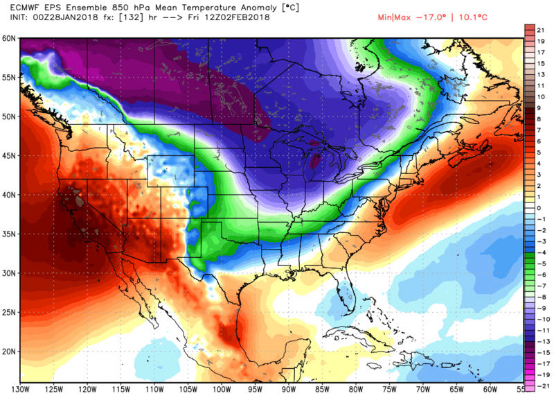
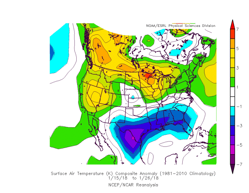
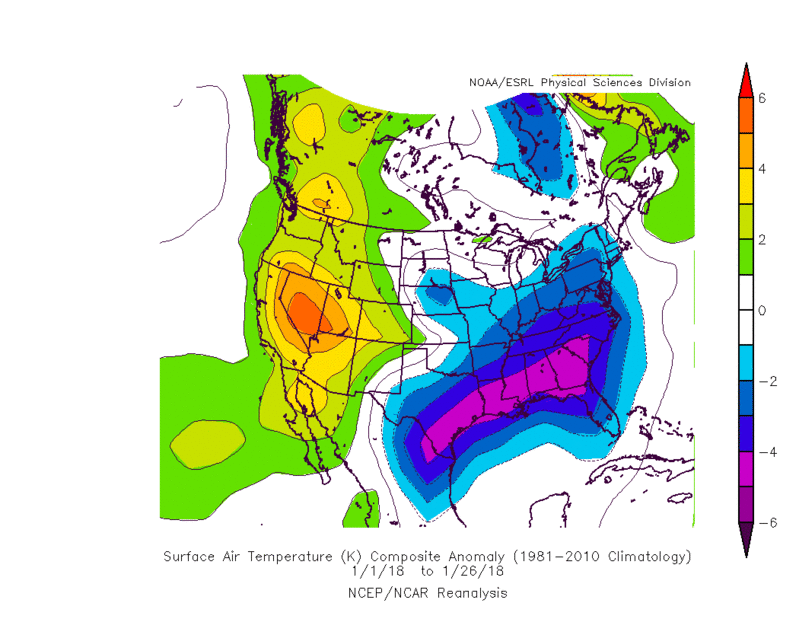
Banter Jman. We aren't even into the period we had been talking about as being more consistently cold and more favorable for snow chances yet, Feb5th-10th and beyond, and yet we have 3 snow chances in front of us. Tonight into tomorrow, Friday, and next Sunday night into Monday. We had the Jan Thaw which was anticipated and ended up much cooler overall than was talked about a couple of weeks ago. The temp anomalies for the month overall will still end up BN in all likely hood. Here are the first two weeks, past two weeks and overall for the month.


Anything we get before Feb5th I personally am considering a bonus. It may not be the sexiest of systems to track in the immediate future but at least its something.
_________________
"In weather and in life, there's no winning and losing; there's only winning and learning."
WINTER 2012/2013 TOTALS 43.65"WINTER 2017/2018 TOTALS 62.85" WINTER 2022/2023 TOTALS 4.9"
WINTER 2013/2014 TOTALS 64.85"WINTER 2018/2019 TOTALS 14.25" WINTER 2023/2024 TOTALS 13.1"
WINTER 2014/2015 TOTALS 71.20"WINTER 2019/2020 TOTALS 6.35"
WINTER 2015/2016 TOTALS 35.00"WINTER 2020/2021 TOTALS 37.75"
WINTER 2016/2017 TOTALS 42.25"WINTER 2021/2022 TOTALS 31.65"
sroc4- Admin
- Posts : 8331
Reputation : 301
Join date : 2013-01-07
Location : Wading River, LI
Re: Long Range Thread 16.0
![]() by Guest Mon Jan 29, 2018 7:57 am
by Guest Mon Jan 29, 2018 7:57 am
Guest- Guest
Re: Long Range Thread 16.0
![]() by Frank_Wx Mon Jan 29, 2018 8:28 am
by Frank_Wx Mon Jan 29, 2018 8:28 am
_________________
_______________________________________________________________________________________________________
CLICK HERE to view NJ Strong Snowstorm Classifications

Frank_Wx- Godzilla Seeker
- Posts : 21305
Reputation : 328
Join date : 2013-01-05
Age : 31
Location : Jersey City, NJ -

Re: Long Range Thread 16.0
![]() by sroc4 Mon Jan 29, 2018 8:37 am
by sroc4 Mon Jan 29, 2018 8:37 am
_________________
"In weather and in life, there's no winning and losing; there's only winning and learning."
WINTER 2012/2013 TOTALS 43.65"WINTER 2017/2018 TOTALS 62.85" WINTER 2022/2023 TOTALS 4.9"
WINTER 2013/2014 TOTALS 64.85"WINTER 2018/2019 TOTALS 14.25" WINTER 2023/2024 TOTALS 13.1"
WINTER 2014/2015 TOTALS 71.20"WINTER 2019/2020 TOTALS 6.35"
WINTER 2015/2016 TOTALS 35.00"WINTER 2020/2021 TOTALS 37.75"
WINTER 2016/2017 TOTALS 42.25"WINTER 2021/2022 TOTALS 31.65"
sroc4- Admin
- Posts : 8331
Reputation : 301
Join date : 2013-01-07
Location : Wading River, LI
Re: Long Range Thread 16.0
![]() by Guest Mon Jan 29, 2018 8:44 am
by Guest Mon Jan 29, 2018 8:44 am
Guest- Guest
Re: Long Range Thread 16.0
![]() by sroc4 Mon Jan 29, 2018 8:46 am
by sroc4 Mon Jan 29, 2018 8:46 am
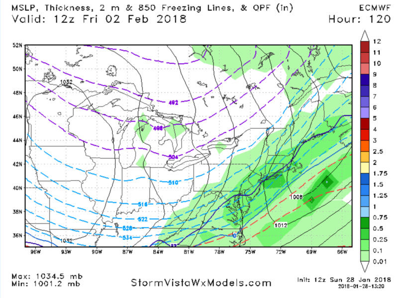
Frank_Wx wrote:Not much amplification in the trough and we're under a progressive flow for anything significant to develop this Friday, in my opinion. Either the low pressure develops too far off the coast, or it turns out to be a frontal passage. A couple of days ago I expressed the pattern is still too "young" to bring us a glorified snowstorm. February 6th-15th is the timeframe I believe holds the best potential.
Agreed Frank regarding the progressive flow. Certainly don’t expect a Godzilla. But the set up is very reminiscent of March 2013/14 where all it takes is a weak low pressure and a favorably positioned frontal boundary to develop south of Long Island to start the warm air advection. The air mass to the north is extremely cold and we still have warm air to our south and east so I think if this happens there will be baroclinically enhanced vertical motion, especially along the coast, and enhance precept totals that usually don’t become evident until the Hi-Rez models take over. Also with northern stream energy historically under model this season before it makes it on shore it won’t take much additional digging into the trough To develop the low pressure along the frontal boundary and enhance the warm air advection and become a nice moderate event. As of now or I should say overnight models have the main trough pretty broad based with the energy associated with it pretty strung out. We shall see.
_________________
"In weather and in life, there's no winning and losing; there's only winning and learning."
WINTER 2012/2013 TOTALS 43.65"WINTER 2017/2018 TOTALS 62.85" WINTER 2022/2023 TOTALS 4.9"
WINTER 2013/2014 TOTALS 64.85"WINTER 2018/2019 TOTALS 14.25" WINTER 2023/2024 TOTALS 13.1"
WINTER 2014/2015 TOTALS 71.20"WINTER 2019/2020 TOTALS 6.35"
WINTER 2015/2016 TOTALS 35.00"WINTER 2020/2021 TOTALS 37.75"
WINTER 2016/2017 TOTALS 42.25"WINTER 2021/2022 TOTALS 31.65"
sroc4- Admin
- Posts : 8331
Reputation : 301
Join date : 2013-01-07
Location : Wading River, LI
Re: Long Range Thread 16.0
![]() by Frank_Wx Mon Jan 29, 2018 10:43 am
by Frank_Wx Mon Jan 29, 2018 10:43 am
syosnow94 wrote:Ok boys. It’s been awhile since the ground was white. Make it happen please!

_________________
_______________________________________________________________________________________________________
CLICK HERE to view NJ Strong Snowstorm Classifications
Frank_Wx- Godzilla Seeker
- Posts : 21305
Reputation : 328
Join date : 2013-01-05
Age : 31
Location : Jersey City, NJ -
Re: Long Range Thread 16.0
![]() by jmanley32 Mon Jan 29, 2018 10:48 am
by jmanley32 Mon Jan 29, 2018 10:48 am
I know this is banter but I figured wasn't a big deal, look at all the crazy stuff that was banter posted in this and the jan thread over the past month, flame throwers mike the warmist come on and you call me out? I'll keep it in banter but just saying. Theres been plenty of banter outside of banter.sroc4 wrote:jmanley32 wrote:this winter is boring i gotta say, i usually dont feel this way but whens spring?
Banter Jman. We aren't even into the period we had been talking about as being more consistently cold and more favorable for snow chances yet, Feb5th-10th and beyond, and yet we have 3 snow chances in front of us. Tonight into tomorrow, Friday, and next Sunday night into Monday. We had the Jan Thaw which was anticipated and ended up much cooler overall than was talked about a couple of weeks ago. The temp anomalies for the month overall will still end up BN in all likely hood. Here are the first two weeks, past two weeks and overall for the month.
Anything we get before Feb5th I personally am considering a bonus. It may not be the sexiest of systems to track in the immediate future but at least its something.
jmanley32- Senior Enthusiast
- Posts : 20517
Reputation : 108
Join date : 2013-12-12
Age : 42
Location : Yonkers, NY
Re: Long Range Thread 16.0
![]() by amugs Mon Jan 29, 2018 1:01 pm
by amugs Mon Jan 29, 2018 1:01 pm
It's more important to utilize ensembles right now to look at overall threat periods and try to figure out how things are going to evolve. We are in a really good spot in that regard...all ensembles are showing very favorable evolutions and there are multiple waves that will have the potential to bring wintry weather.
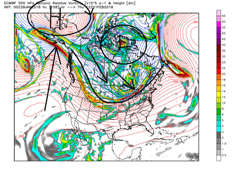
Look at he PAC - THIS IS WHERE IT LIES FOR THE LOVE OF GOD!!!!!!!!!

See teh wave breaks - the roller coaster esque flow - this will pump the EPO and give us another poleward extension. This buckle in teh JET is important for our weather downstream from this. It will allow for a PNA to spike as well.
Look at this map:


You see the MASSIVE EPO but look a the North Atlantic with that huge height rise (orangy colors) - that is our WAr or WEstern Atlantic Ridge that will help push/guide teh storms towards the coast and slow things down a bit. Not a true - NAO but a pseudo type block.
See that codl core over Central Canada - this is a type pattern ala 2015. WE will have many northern vorts, sw (short Waves) whatever yuo want to call them rotate around the base of this PV - this is why Earthlight and others are excited about teh timeframe coming up as Frank mentioned. have some patience and once it gets set it is game on in a possibly BIGGIE way (secs/mecs storms).
Okay I really like a moderate type event with tsi set - the "horse shoe" locking in teh trough - WOW Sunday night into Monday lets do this for the American people who want to sleep in after teh Super bowl here in the NE

Lastly MJO going into phase 8 - by my experience a phase 7 MJO is not all that warm as the plots call for on the East coast but more transitional. We head to 8 then hopefully around teh horn to 3 for march - teh weenie in me!!!

_________________
Mugs
AKA:King: Snow Weenie
Self Proclaimed
WINTER 2014-15 : 55.12" +.02 for 6 coatings (avg. 35")
WINTER 2015-16 Total - 29.8" (Avg 35")
WINTER 2016-17 : 39.5" so far

amugs- Advanced Forecaster - Mod
- Posts : 15093
Reputation : 213
Join date : 2013-01-07
Age : 54
Location : Hillsdale,NJ
Re: Long Range Thread 16.0
![]() by amugs Mon Jan 29, 2018 1:35 pm
by amugs Mon Jan 29, 2018 1:35 pm


Monday close


_________________
Mugs
AKA:King: Snow Weenie
Self Proclaimed
WINTER 2014-15 : 55.12" +.02 for 6 coatings (avg. 35")
WINTER 2015-16 Total - 29.8" (Avg 35")
WINTER 2016-17 : 39.5" so far
amugs- Advanced Forecaster - Mod
- Posts : 15093
Reputation : 213
Join date : 2013-01-07
Age : 54
Location : Hillsdale,NJ
Re: Long Range Thread 16.0
![]() by Snow88 Mon Jan 29, 2018 5:44 pm
by Snow88 Mon Jan 29, 2018 5:44 pm

Snow88- Senior Enthusiast
- Posts : 2193
Reputation : 4
Join date : 2013-01-09
Age : 35
Location : Brooklyn, NY
Page 33 of 40 • 1 ... 18 ... 32, 33, 34 ... 36 ... 40 ![]()
|
|
|