
 Search
Long Range Thread 16.0
+44
snowday111
HectorO
Grselig
essexcountypete
Snow88
mwilli5783
WeatherBob
NjWeatherGuy
Dunnzoo
jake732
aiannone
crippo84
bobjohnsonforthehall
Scullybutcher
algae888
dsix85
dkodgis
sroc4
emokid51783
Math23x7
Sanchize06
docstox12
billg315
oldtimer
CPcantmeasuresnow
skinsfan1177
Quietace
SENJsnowman
lglickman1
hyde345
MattyICE
Carter bk
RJB8525
jimv45
amugs
GreyBeard
weatherwatchermom
SoulSingMG
nutleyblizzard
mikeypizano
rb924119
frank 638
jmanley32
Frank_Wx
48 posters
Page 40 of 40
Page 40 of 40 •  1 ... 21 ... 38, 39, 40
Re: Long Range Thread 16.0
![]() by weatherwatchermom Fri Feb 09, 2018 10:45 am
by weatherwatchermom Fri Feb 09, 2018 10:45 am
sroc4 wrote:Evolution of the 10mb strat...Jan 23rd, Feb 3rd, Feb 9th...pay particular attention in the first two images there is a large ridge on the left side of the vortex, but in the last 5 days a second lobe/ridge has appeared on the R side. In 3 more days the ridges on the L and R sides will link over top of the arctic circle in spectacular fashion splitting the strat polar vortex into two lobes..
In 3 days it will look like this...
I mentioned yesterday the GFS has hands down been the better of the two between it and euro forecasting the MJO. Here was the GEFS MJO From Feb 6th showing the hint at phase 8 but Feb 7th its back to getting stuck in 7 vs the euro that still seems to be correcting to the GEFS but still has it decreasing amplitude and getting into 8. Until I see the MJO make some headway towards 8 I will pause....BUT with how significant (I and I cant stress this enough) the changes will be to the strat in the upcoming 3-7days, there will be a huge atmospheric shake up. The period to watch is Feb20th-23rd-Mid March for the real deal Holyfield, but I am still watching the 16th-18th VERY closely for a wintery event.
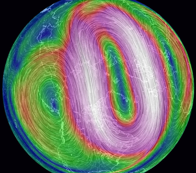
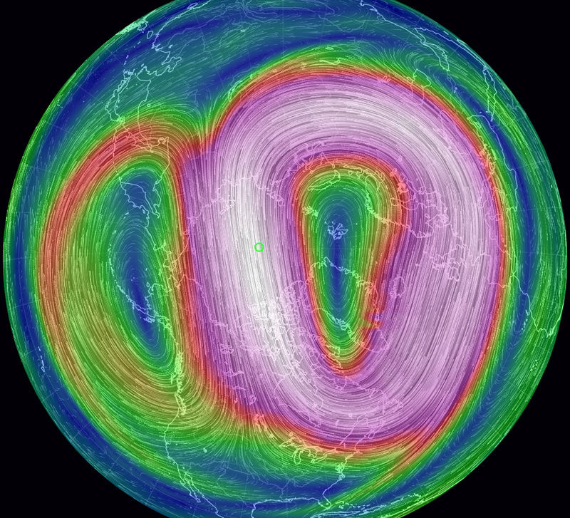


Scroc...I have faith..not giving up!! ps..where did you get the top three maps from they are really beautiful to see....
weatherwatchermom- Senior Enthusiast

- Posts : 3793
Join date : 2014-11-25
Re: Long Range Thread 16.0
![]() by sroc4 Fri Feb 09, 2018 10:51 am
by sroc4 Fri Feb 09, 2018 10:51 am
weatherwatchermom wrote:sroc4 wrote:Evolution of the 10mb strat...Jan 23rd, Feb 3rd, Feb 9th...pay particular attention in the first two images there is a large ridge on the left side of the vortex, but in the last 5 days a second lobe/ridge has appeared on the R side. In 3 more days the ridges on the L and R sides will link over top of the arctic circle in spectacular fashion splitting the strat polar vortex into two lobes..
I mentioned yesterday the GFS has hands down been the better of the two between it and euro forecasting the MJO. Here was the GEFS MJO From Feb 6th showing the hint at phase 8 but Feb 7th its back to getting stuck in 7 vs the euro that still seems to be correcting to the GEFS but still has it decreasing amplitude and getting into 8. Until I see the MJO make some headway towards 8 I will pause....BUT with how significant (I and I cant stress this enough) the changes will be to the strat in the upcoming 3-7days, there will be a huge atmospheric shake up. The period to watch is Feb20th-23rd-Mid March for the real deal Holyfield, but I am still watching the 16th-18th VERY closely for a wintery event.
Scroc...I have faith..not giving up!! ps..where did you get the top three maps from they are really beautiful to see....
Here is the link. Its a really cool site. Hover the mouse over the earth and left click and hold it down. You can then adjust your view of the globe. With the little wheel thing in between left and right click bottons on the mouse you can zoom in or out over any specific location. In the bottom L corner click on the word earth and you can pick which level of the atmosphere you want to look at from sfc to 10mb(or HPa) in the atmosphere where it says height. You can also switch and look at ocean currents as well. Its a great site.
https://earth.nullschool.net/#current/wind/isobaric/500hPa/orthographic=-97.37,21.15,420
sroc4- Admin

- Posts : 8354
Join date : 2013-01-07
Re: Long Range Thread 16.0
![]() by weatherwatchermom Fri Feb 09, 2018 12:48 pm
by weatherwatchermom Fri Feb 09, 2018 12:48 pm
sroc4 wrote:weatherwatchermom wrote:sroc4 wrote:Evolution of the 10mb strat...Jan 23rd, Feb 3rd, Feb 9th...pay particular attention in the first two images there is a large ridge on the left side of the vortex, but in the last 5 days a second lobe/ridge has appeared on the R side. In 3 more days the ridges on the L and R sides will link over top of the arctic circle in spectacular fashion splitting the strat polar vortex into two lobes..
I mentioned yesterday the GFS has hands down been the better of the two between it and euro forecasting the MJO. Here was the GEFS MJO From Feb 6th showing the hint at phase 8 but Feb 7th its back to getting stuck in 7 vs the euro that still seems to be correcting to the GEFS but still has it decreasing amplitude and getting into 8. Until I see the MJO make some headway towards 8 I will pause....BUT with how significant (I and I cant stress this enough) the changes will be to the strat in the upcoming 3-7days, there will be a huge atmospheric shake up. The period to watch is Feb20th-23rd-Mid March for the real deal Holyfield, but I am still watching the 16th-18th VERY closely for a wintery event.
Scroc...I have faith..not giving up!! ps..where did you get the top three maps from they are really beautiful to see....
Here is the link. Its a really cool site. Hover the mouse over the earth and left click and hold it down. You can then adjust your view of the globe. With the little wheel thing in between left and right click bottons on the mouse you can zoom in or out over any specific location. In the bottom L corner click on the word earth and you can pick which level of the atmosphere you want to look at from sfc to 10mb(or HPa) in the atmosphere where it says height. You can also switch and look at ocean currents as well. Its a great site.
https://earth.nullschool.net/#current/wind/isobaric/500hPa/orthographic=-97.37,21.15,420
yes...I thought that was the site...I just did not know you could change anything...I just played with the site...Thanks Again!! have a good weekend..

weatherwatchermom- Senior Enthusiast
- Posts : 3793
Reputation : 78
Join date : 2014-11-25
Location : Hazlet Township, NJ
Re: Long Range Thread 16.0
![]() by Math23x7 Fri Feb 09, 2018 3:13 pm
by Math23x7 Fri Feb 09, 2018 3:13 pm
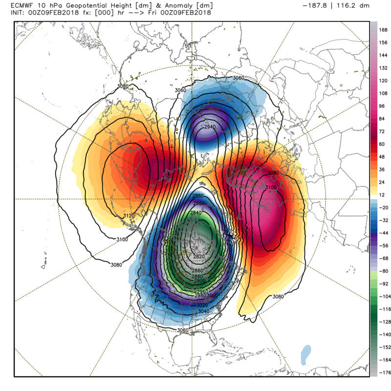
I'll say this: I am suspicious of this image, which is the Day 12-16 500 mb height anomaly from today's 12Z GFS-ENS. I mean, looking at this, we have ridging in Greenland and ridging in the Eastern Pacific. Yet, despite these two features, there is a massive ridge in our neck of the woods:

Of course, when you zoom out, you get some sense of what is happening. The ridging in the North Atlantic actually extends towards Scandinavia and there is somewhat of a trough in East Asia and the Western Pacific:
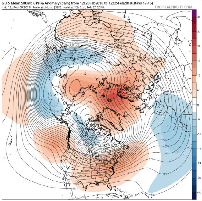
Yet, I'm still puzzled about the idea of the Eastern Pacific, the eastern US, and Greenland all under ridges. Something doesn't seem to be right and I expect model guidance to correct itself as we approach President's weekend.
Of course, when you zoom out, you get some sense of what is happening. The ridging in the North Atlantic actually extends towards Scandinavia and there is somewhat of a trough in East Asia and the Western Pacific:
Yet, I'm still puzzled about the idea of the Eastern Pacific, the eastern US, and Greenland all under ridges. Something doesn't seem to be right and I expect model guidance to correct itself as we approach President's weekend.
Math23x7- Wx Statistician Guru

- Posts : 2379
Reputation : 68
Join date : 2013-01-08
Re: Long Range Thread 16.0
![]() by sroc4 Fri Feb 09, 2018 3:40 pm
by sroc4 Fri Feb 09, 2018 3:40 pm
Math23x7 wrote:I'll say this: I am suspicious of this image, which is the Day 12-16 500 mb height anomaly from today's 12Z GFS-ENS. I mean, looking at this, we have ridging in Greenland and ridging in the Eastern Pacific. Yet, despite these two features, there is a massive ridge in our neck of the woods:
Of course, when you zoom out, you get some sense of what is happening. The ridging in the North Atlantic actually extends towards Scandinavia and there is somewhat of a trough in East Asia and the Western Pacific:
Yet, I'm still puzzled about the idea of the Eastern Pacific, the eastern US, and Greenland all under ridges. Something doesn't seem to be right and I expect model guidance to correct itself as we approach President's weekend.
Atta boy Mikey!!!!! Love the analysis...not just because it shows what most of us want.
_________________
"In weather and in life, there's no winning and losing; there's only winning and learning."
WINTER 2012/2013 TOTALS 43.65"WINTER 2017/2018 TOTALS 62.85" WINTER 2022/2023 TOTALS 4.9"
WINTER 2013/2014 TOTALS 64.85"WINTER 2018/2019 TOTALS 14.25" WINTER 2023/2024 TOTALS 13.1"
WINTER 2014/2015 TOTALS 71.20"WINTER 2019/2020 TOTALS 6.35"
WINTER 2015/2016 TOTALS 35.00"WINTER 2020/2021 TOTALS 37.75"
WINTER 2016/2017 TOTALS 42.25"WINTER 2021/2022 TOTALS 31.65"

sroc4- Admin
- Posts : 8354
Reputation : 302
Join date : 2013-01-07
Location : Wading River, LI
Re: Long Range Thread 16.0
![]() by amugs Fri Feb 09, 2018 5:25 pm
by amugs Fri Feb 09, 2018 5:25 pm
Math has resurrected from the dark ashes!! Very good analysis kid.
_________________
Mugs
AKA:King: Snow Weenie
Self Proclaimed
WINTER 2014-15 : 55.12" +.02 for 6 coatings (avg. 35")
WINTER 2015-16 Total - 29.8" (Avg 35")
WINTER 2016-17 : 39.5" so far

amugs- Advanced Forecaster - Mod

- Posts : 15095
Reputation : 213
Join date : 2013-01-07
Age : 54
Location : Hillsdale,NJ
Re: Long Range Thread 16.0
![]() by rb924119 Sat Feb 10, 2018 6:14 pm
by rb924119 Sat Feb 10, 2018 6:14 pm
I'm either stepping away from the board for a while, or coming out with a rage-video because I can't take the negativity and blatant misinterpretation of what's going on any longer lol and no, this is not meant to be a jab at people less well-versed not knowing or understanding, just frustration at the fact that they are writing everything off because some website is forecasting "warmth". I may be back, I may not. I don't know. I gotta cool off, but please take a step back and look at the broader picture - don't focus on the fine details or the here and now. Ciao for now.
rb924119- Meteorologist

- Posts : 6928
Reputation : 194
Join date : 2013-02-06
Age : 32
Location : Greentown, Pa
Re: Long Range Thread 16.0
![]() by Grselig Sat Feb 10, 2018 6:34 pm
by Grselig Sat Feb 10, 2018 6:34 pm
rb924119 wrote:I'm either stepping away from the board for a while, or coming out with a rage-video because I can't take the negativity and blatant misinterpretation of what's going on any longer lol and no, this is not meant to be a jab at people less well-versed not knowing or understanding, just frustration at the fact that they are writing everything off because some website is forecasting "warmth". I may be back, I may not. I don't know. I gotta cool off, but please take a step back and look at the broader picture - don't focus on the fine details or the here and now. Ciao for now.
Hope u decide to come back. Your analysis is always informative and instructive. Whatever you decide, thanks for your work! You are a pro.

Grselig- Senior Enthusiast
- Posts : 1408
Reputation : 140
Join date : 2013-03-04
Age : 54
Location : Wayne NJ
Re: Long Range Thread 16.0
![]() by Snow88 Sat Feb 10, 2018 8:53 pm
by Snow88 Sat Feb 10, 2018 8:53 pm
rb924119 wrote:I'm either stepping away from the board for a while, or coming out with a rage-video because I can't take the negativity and blatant misinterpretation of what's going on any longer lol and no, this is not meant to be a jab at people less well-versed not knowing or understanding, just frustration at the fact that they are writing everything off because some website is forecasting "warmth". I may be back, I may not. I don't know. I gotta cool off, but please take a step back and look at the broader picture - don't focus on the fine details or the here and now. Ciao for now.
Who leaves because people are negative ? LOL
Anyway, too many people are giving up on winter right now which is foolish.

Snow88- Senior Enthusiast
- Posts : 2193
Reputation : 4
Join date : 2013-01-09
Age : 35
Location : Brooklyn, NY
Re: Long Range Thread 16.0
![]() by billg315 Sun Feb 11, 2018 8:54 am
by billg315 Sun Feb 11, 2018 8:54 am
It is foolish for anyone to give up on winter before March. Some of our best snow storms are in March and sometimes we even get an April surprise. I feel like a broken record because I feel like I post this every year around this time. Lol. That said I can’t blame people for being frustrated or skeptical. I remember Mike being criticized in mid January for suggesting we might not get a pattern change until after Presidents Day. Well it’s 48 and raining today and hitting near 60 later this week. So he appears to have been correct. (Good thing I didn’t convict you in OTI Court Mike  ) All of that said let’s see how things develop as we head into the homestretch of Feb and early March. There is PLENTY of time for the pattern to flip.

billg315- Advanced Forecaster - Mod
- Posts : 4483
Reputation : 185
Join date : 2015-01-24
Age : 50
Location : Flemington, NJ
Re: Long Range Thread 16.0
![]() by sroc4 Sun Feb 11, 2018 8:59 am
by sroc4 Sun Feb 11, 2018 8:59 am
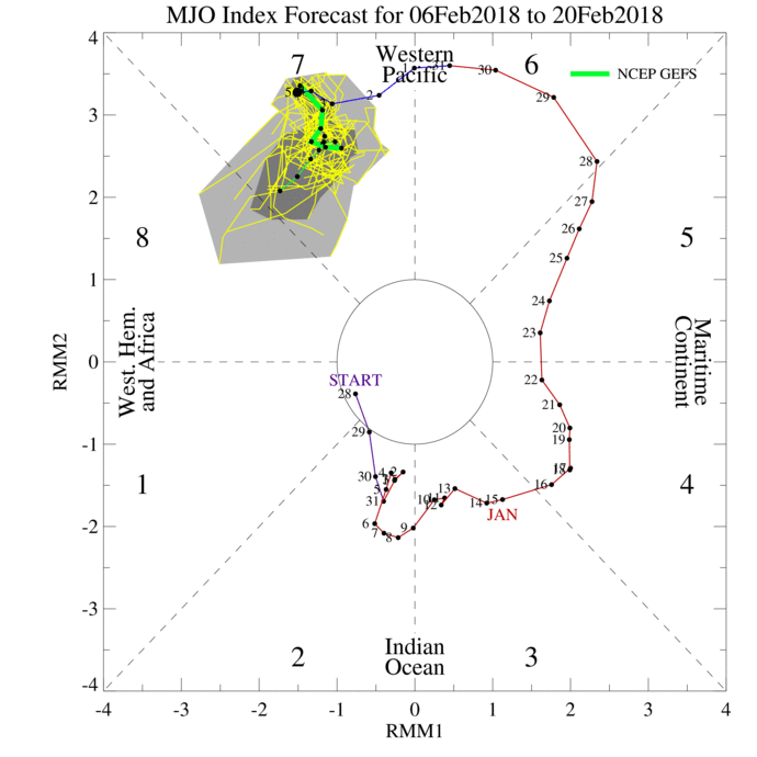
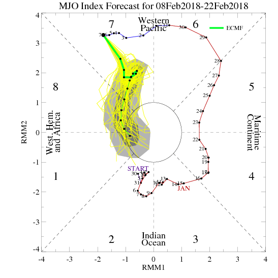
Lets just say...I'm nervous. Its hard not to look at both the GEFS AND EPS ensemble means in the LR and not get discouraged. As has been stated a number of times, the GEFS have led the way regarding the MJO forecasts. The anomalous amplitude/intensity and long duration of the MJO wave propagation through the warm phases of 4-5-6-7, combined with our La Nina base state, has been the main reason why we have seen the weather we have, and why the "pattern change" to the one we all want has yet to show up.
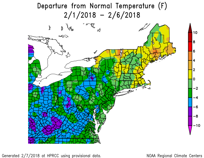
Now despite the fact that the "pattern Change" to say deep trough in the east, well BN temp departures, with snowstorm after snow storm didn't happen to this point, we did in fact have a pattern change. Our pattern that was the Jan thaw beginning Mid Jan leading into Feb did in fact change even though it was less than ideal. Go back in this thread and you will see tthat two successive Wave 1 attacks on the strat allowed for our shift from AN temps for the second half of Jan to BN temps and several snow chances for the first part of Feb. In prev write ups leading into Feb I stated that the period between the 2nd/3rd and 10th would feature BN to N temps with at least 2 maybe 3 chances at snow. That forecast verified. Here are the temp departures from Mid Jan through Feb 10th and you can clearly see the AN temps due to the "thaw", but if you simply look at the time from Feb 1st through the 10th we had BN temps with the exception of the immediate coast which hovers around N.

We had several systems that produced accumulating snow. Unfort accumulations were confined for the most part to N&W of NYC because the baroclinic zone remained a tad too far north. The coastal plain did not have much of a chance to accumulate, because the MJO influences on the pattern led to a storm track along the baroclinic zone such that the coast would warm sector out ahead of the systems followed by cold air coming in behind.
Now you don't have to like it, but this was all recognized with plenty of lead time. It is not my fault if you read something by me or others thinking after Feb 3-5th we were going to rock and roll but failed to read the adjustments made to that forecast.
Now the forecast going forward is highly contingent upon the MJO propagation into phases 8-1-2 and the ultimate result of the current SSWE under way. The reason I am getting nercous is two fold. The details off which I will outline in the week to come. Here are my reservations in summary.
1) If we cannot get the MJO wave into 8-1-or 2 we will struggle. GEFS still do not show this happening, while the EPS has slowly been backing off on its progression into 8. Remember GEFS have done a much better job forecasting the MJO.
2) The result of strat warming (sswe) may be such that the trough may be forced to remain in the west due to both position of the displaced strat PV as well as the strength of the displaced strat PV.
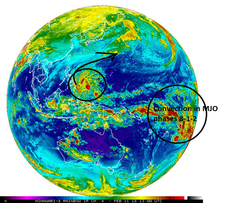
That said this is not me giving up on the original ideas of a period after the 20th-2rd through mid march or so of cold and snow chances. BECAUSE there is a typhoon moving E to W through phases 6-5-4 of the MJO which when looking at current sat imagery is def having an influence on the pattern. There is latent heat release into the upper level pattern that can be seen on water vapor imagery affecting the polar and Pac jet streams in the Western Pac.
http://www.goes.noaa.gov/dml/jma/fd/wvblue.html
That said there is also convection firing over MJO phases 8-1-2. The euro which has been forecasting the MJO into 8 even though its amplitude has been adjusting doesn't doi so until around the 16th or so of Feb +/- a day. If it does so we will get a favorable period for snow and cold chances. I do not believe the BN temp departures will be as anomalously low like we saw during the period between Xmas and Mid Jan, but I do believe it will be BN to N similar to what we just experienced; however, the difference would be in the overall pattern configuration should be more favorable for more significant cyclogenesis which would tap into the colder air just to the north with a storm track up the coast vs off the coast.
Keep all the whining, complaining, and blaming of me or anyone else for not seeing what you want in the banter thread. AND REMEMBER...IF IT DOESNT WORK OUT THERE IS REASONING AS TO WHY THAT IS BEING LAYED OUT BOTH HERE AND IN SUBSEQUENT WRITE UPS. THIS ISNT AN EXCUSE, BUT RATHER ITS A REALIZATION THAT WE ARE NOT GOD, AND AT THE END OF THE DAY WE LEARN FROM OUR MISTAKES SO THAT IN THE FUTURE WE CAN BECOME BETTER. WHILE WE HOPE FOR A NICE PERIOD OF 2-4WEEKS OF SNOW AND COLD TO END THE SEASON IT MAY NOT WORK OUT THAT WAY SO GET OVER IT.
Now despite the fact that the "pattern Change" to say deep trough in the east, well BN temp departures, with snowstorm after snow storm didn't happen to this point, we did in fact have a pattern change. Our pattern that was the Jan thaw beginning Mid Jan leading into Feb did in fact change even though it was less than ideal. Go back in this thread and you will see tthat two successive Wave 1 attacks on the strat allowed for our shift from AN temps for the second half of Jan to BN temps and several snow chances for the first part of Feb. In prev write ups leading into Feb I stated that the period between the 2nd/3rd and 10th would feature BN to N temps with at least 2 maybe 3 chances at snow. That forecast verified. Here are the temp departures from Mid Jan through Feb 10th and you can clearly see the AN temps due to the "thaw", but if you simply look at the time from Feb 1st through the 10th we had BN temps with the exception of the immediate coast which hovers around N.
We had several systems that produced accumulating snow. Unfort accumulations were confined for the most part to N&W of NYC because the baroclinic zone remained a tad too far north. The coastal plain did not have much of a chance to accumulate, because the MJO influences on the pattern led to a storm track along the baroclinic zone such that the coast would warm sector out ahead of the systems followed by cold air coming in behind.
Now you don't have to like it, but this was all recognized with plenty of lead time. It is not my fault if you read something by me or others thinking after Feb 3-5th we were going to rock and roll but failed to read the adjustments made to that forecast.
Now the forecast going forward is highly contingent upon the MJO propagation into phases 8-1-2 and the ultimate result of the current SSWE under way. The reason I am getting nercous is two fold. The details off which I will outline in the week to come. Here are my reservations in summary.
1) If we cannot get the MJO wave into 8-1-or 2 we will struggle. GEFS still do not show this happening, while the EPS has slowly been backing off on its progression into 8. Remember GEFS have done a much better job forecasting the MJO.
2) The result of strat warming (sswe) may be such that the trough may be forced to remain in the west due to both position of the displaced strat PV as well as the strength of the displaced strat PV.
That said this is not me giving up on the original ideas of a period after the 20th-2rd through mid march or so of cold and snow chances. BECAUSE there is a typhoon moving E to W through phases 6-5-4 of the MJO which when looking at current sat imagery is def having an influence on the pattern. There is latent heat release into the upper level pattern that can be seen on water vapor imagery affecting the polar and Pac jet streams in the Western Pac.
http://www.goes.noaa.gov/dml/jma/fd/wvblue.html
That said there is also convection firing over MJO phases 8-1-2. The euro which has been forecasting the MJO into 8 even though its amplitude has been adjusting doesn't doi so until around the 16th or so of Feb +/- a day. If it does so we will get a favorable period for snow and cold chances. I do not believe the BN temp departures will be as anomalously low like we saw during the period between Xmas and Mid Jan, but I do believe it will be BN to N similar to what we just experienced; however, the difference would be in the overall pattern configuration should be more favorable for more significant cyclogenesis which would tap into the colder air just to the north with a storm track up the coast vs off the coast.
Keep all the whining, complaining, and blaming of me or anyone else for not seeing what you want in the banter thread. AND REMEMBER...IF IT DOESNT WORK OUT THERE IS REASONING AS TO WHY THAT IS BEING LAYED OUT BOTH HERE AND IN SUBSEQUENT WRITE UPS. THIS ISNT AN EXCUSE, BUT RATHER ITS A REALIZATION THAT WE ARE NOT GOD, AND AT THE END OF THE DAY WE LEARN FROM OUR MISTAKES SO THAT IN THE FUTURE WE CAN BECOME BETTER. WHILE WE HOPE FOR A NICE PERIOD OF 2-4WEEKS OF SNOW AND COLD TO END THE SEASON IT MAY NOT WORK OUT THAT WAY SO GET OVER IT.
Last edited by sroc4 on Sun Feb 11, 2018 10:04 am; edited 1 time in total
_________________
"In weather and in life, there's no winning and losing; there's only winning and learning."
WINTER 2012/2013 TOTALS 43.65"WINTER 2017/2018 TOTALS 62.85" WINTER 2022/2023 TOTALS 4.9"
WINTER 2013/2014 TOTALS 64.85"WINTER 2018/2019 TOTALS 14.25" WINTER 2023/2024 TOTALS 13.1"
WINTER 2014/2015 TOTALS 71.20"WINTER 2019/2020 TOTALS 6.35"
WINTER 2015/2016 TOTALS 35.00"WINTER 2020/2021 TOTALS 37.75"
WINTER 2016/2017 TOTALS 42.25"WINTER 2021/2022 TOTALS 31.65"
sroc4- Admin
- Posts : 8354
Reputation : 302
Join date : 2013-01-07
Location : Wading River, LI
billg315- Advanced Forecaster - Mod
- Posts : 4483
Reputation : 185
Join date : 2015-01-24
Age : 50
Location : Flemington, NJ
Re: Long Range Thread 16.0
![]() by CPcantmeasuresnow Sun Feb 11, 2018 12:07 pm
by CPcantmeasuresnow Sun Feb 11, 2018 12:07 pm
rb924119 wrote:I'm either stepping away from the board for a while, or coming out with a rage-video because I can't take the negativity and blatant misinterpretation of what's going on any longer lol and no, this is not meant to be a jab at people less well-versed not knowing or understanding, just frustration at the fact that they are writing everything off because some website is forecasting "warmth". I may be back, I may not. I don't know. I gotta cool off, but please take a step back and look at the broader picture - don't focus on the fine details or the here and now. Ciao for now.
Curious what this is all about?
If you're reading the banter thread anything goes. I've been known to throw in the towel in mid November on the banter thread, but that's what it's there for to vent. If you're reading stuff on any other threads that's banter and not in the banter thread you have a point.
Now post that damn long range video, and it better be good or else.
Sorry that last line was banter.

CPcantmeasuresnow- Wx Statistician Guru
- Posts : 7274
Reputation : 230
Join date : 2013-01-07
Age : 103
Location : Eastern Orange County, NY
Re: Long Range Thread 16.0
![]() by amugs Sun Feb 11, 2018 1:56 pm
by amugs Sun Feb 11, 2018 1:56 pm
@rb my man if you do read this just take a day or two away from here and or three and then please come back. You are to valuable of a poster and pro met to leave us. Don't let the sins of a few ruin it for the many as yuo are most welcomed and revered here.
Scott I am in your boat and thanks for teh at length and informative post. Please as some will say on here we busted and dont believe in LR blah blah blah BUT the fact is no one and please those who are saying see I knew winter is over , no one saw this progression of teh MJO with this trop storm basically stalling in the PAC in phase seven. We posted at lenth the SOI was crashing hard and we had a WWB that woudl aid in moving the tropical wave into phases 8,1 and then possibly 2 but today's model runs and sat radars aren't in favor of this at this time. THE SSW event is historical to say the least as most mets who study this - Dr. Amy Butler for one has been harping on, the complete PV in the Start gets destroyed and this is due in part to strong E QBO at -17 value and the strong phase 7 MJO. So the SE ridge will overwhelm the pattern as such with this forcing and we look to see over teh next few days what the MJO wave does and the SSW.
What some don't get is that it is not just one piece that will make our pattern but many variable when it come to winter and what is happening 10,000 plus miles away has a profound effect on this in both directions - upstream and downstream.
We are in a typical Nina esque pattern with storms running west of us up the Apps spine or into the ST Lawrence River Valley.
MJO GEFS
.gif)
FROM Joe D
The MEI dropped to -0.62 maintaining the weak La Nina status. Wolter notes in his monthly MEI update "continued La Niña conditions are more likely than not for the next few months, but a transition to at least a short-lived El Niño is more likely than continued La Niña later this year."
SST this is not helping have 1.2 equal to 3.4


All the convection of LP stuck West of the Dateline - CP, DOC fart and blow this east for us!!!
.png)
The typhoon recurves thgus sticking the MJO in Phase 7 which promotes atrough in the Western USA and the SE Ridge to have its glory on us EC
Hope for the best and I may step away for a day or two or three meself.
Scott I am in your boat and thanks for teh at length and informative post. Please as some will say on here we busted and dont believe in LR blah blah blah BUT the fact is no one and please those who are saying see I knew winter is over , no one saw this progression of teh MJO with this trop storm basically stalling in the PAC in phase seven. We posted at lenth the SOI was crashing hard and we had a WWB that woudl aid in moving the tropical wave into phases 8,1 and then possibly 2 but today's model runs and sat radars aren't in favor of this at this time. THE SSW event is historical to say the least as most mets who study this - Dr. Amy Butler for one has been harping on, the complete PV in the Start gets destroyed and this is due in part to strong E QBO at -17 value and the strong phase 7 MJO. So the SE ridge will overwhelm the pattern as such with this forcing and we look to see over teh next few days what the MJO wave does and the SSW.
What some don't get is that it is not just one piece that will make our pattern but many variable when it come to winter and what is happening 10,000 plus miles away has a profound effect on this in both directions - upstream and downstream.
We are in a typical Nina esque pattern with storms running west of us up the Apps spine or into the ST Lawrence River Valley.
MJO GEFS
FROM Joe D
The MEI dropped to -0.62 maintaining the weak La Nina status. Wolter notes in his monthly MEI update "continued La Niña conditions are more likely than not for the next few months, but a transition to at least a short-lived El Niño is more likely than continued La Niña later this year."
SST this is not helping have 1.2 equal to 3.4
All the convection of LP stuck West of the Dateline - CP, DOC fart and blow this east for us!!!
The typhoon recurves thgus sticking the MJO in Phase 7 which promotes atrough in the Western USA and the SE Ridge to have its glory on us EC
Hope for the best and I may step away for a day or two or three meself.
_________________
Mugs
AKA:King: Snow Weenie
Self Proclaimed
WINTER 2014-15 : 55.12" +.02 for 6 coatings (avg. 35")
WINTER 2015-16 Total - 29.8" (Avg 35")
WINTER 2016-17 : 39.5" so far
amugs- Advanced Forecaster - Mod
- Posts : 15095
Reputation : 213
Join date : 2013-01-07
Age : 54
Location : Hillsdale,NJ
Re: Long Range Thread 16.0
![]() by Guest Sun Feb 11, 2018 4:15 pm
by Guest Sun Feb 11, 2018 4:15 pm
I don’t know if some of the frustration has been because of me so......
I’m a guy that goes by feel and what I see when it comes to weather. My approach is admittedly non scientific and therefore has no factual data behind it but.....I believe we are entitled to post our pessimistic viewpoints as well. No one has to read my posts if they don’t want to. I also go out of my way to not attack anyone personally and actually go to great lengths to defend the Mets on here. If my posts have caused Scott or rb any agida then I’m truly sorry. However too bad! It turns out I may have been right. Was it luck yeah probably but still when things don’t work out as they were forecast by many on here I can get frustrated and post as such. As long as I’m not disrespectful which I’m not.
We are running out of time and it’s becomming clear in the modeling as well.
Guest- Guest
Re: Long Range Thread 16.0
![]() by track17 Sun Feb 11, 2018 4:42 pm
by track17 Sun Feb 11, 2018 4:42 pm
Syo don't apologize at all. Your posts are amazing. You have been the true king of forecasting the past few yrs. I really appreciate all that you do. You know more then most here and do a fantastic job. Thank you for your hard work.
track17- Posts : 454
Reputation : 4
Join date : 2016-01-09
Re: Long Range Thread 16.0
![]() by CPcantmeasuresnow Sun Feb 11, 2018 5:16 pm
by CPcantmeasuresnow Sun Feb 11, 2018 5:16 pm
track17 wrote:Syo don't apologize at all. Your posts are amazing. You have been the true king of forecasting the past few yrs. I really appreciate all that you do. You know more then most here and do a fantastic job. Thank you for your hard work.
I'm confused, what hard work?
If it doesn't snow or gets mild he rants and gets annoyed the same as the rest of us. I can tell you as a brother ranter of his it takes almost no effort, so please don't take it seriously.
CPcantmeasuresnow- Wx Statistician Guru
- Posts : 7274
Reputation : 230
Join date : 2013-01-07
Age : 103
Location : Eastern Orange County, NY
Re: Long Range Thread 16.0
![]() by Guest Sun Feb 11, 2018 5:23 pm
by Guest Sun Feb 11, 2018 5:23 pm
.CPcantmeasuresnow wrote:track17 wrote:Syo don't apologize at all. Your posts are amazing. You have been the true king of forecasting the past few yrs. I really appreciate all that you do. You know more then most here and do a fantastic job. Thank you for your hard work.
I'm confused, what hard work?
If it doesn't snow or gets mild he rants and gets annoyed the same as the rest of us. I can tell you as a brother ranter of his it takes almost no effort, so please don't take it seriously.
He’s being a sarcastic jerk CP. just ignore him. And I don’t even know if they were frustrated with me or not Track so lay off. Don’t need you stirring the pot. I don’t make any forecasts either so I don’t know what the hell uoure talking about. My post was intended to calm things down and you’re being a shit stirrer. Not cool
-------
https://www.njstrongweatherforum.com/viewtopic.forum?t=892
Guest- Guest
Page 40 of 40 • 1 ... 21 ... 38, 39, 40
Page 40 of 40
Permissions in this forum:
You cannot reply to topics in this forum|
|
|