January 16th-17th Snow Event
+31
Radz
ak926
Vinnydula
essexcountypete
Dunnzoo
Taffy
jldio
bobjohnsonforthehall
Dtone
King-Ubas
NjWeatherGuy
2004blackwrx
weatherwatchermom
CPcantmeasuresnow
frank 638
algae888
dkodgis
billg315
Math23x7
Snow88
RJB8525
hyde345
jimv45
rb924119
jmanley32
amugs
aiannone
mikeypizano
docstox12
sroc4
Frank_Wx
35 posters
Page 1 of 15
Page 1 of 15 • 1, 2, 3 ... 8 ... 15 
 January 16th-17th Snow Event
Good Morning,
As you likely heard by now we have some snow on the way beginning Tuesday afternoon through Wednesday morning. The GFS shows light snow falling from 2pm Tuesday to 10am Wednesday. It even tries to pop a coastal low to bring about moderate to heavy snow over portions of Long Island and southern New England. Surface temperatures look to be above freezing for the immediate coast, including NYC, but boundary temps are plentiful cold to support snow and not rain or mix. Due to the light intensity of the snow I am not expecting much accumulation on major roadways. Side roads and cold surfaces will get covered, however.
I am thinking 1-3 inches for SNJ, CNJ, and the Jersey Shore. 2-4 inches for LI, NYC, NE NJ. 3-6" is possible for NW NJ, N&W of NYC, and much of east-central and NE PA.
Start time likely to be 11am Tuesday (for NYC, earlier west) with an end time overnight Tuesday.

_________________
_______________________________________________________________________________________________________
CLICK HERE to view NJ Strong Snowstorm Classifications
 Re: January 16th-17th Snow Event
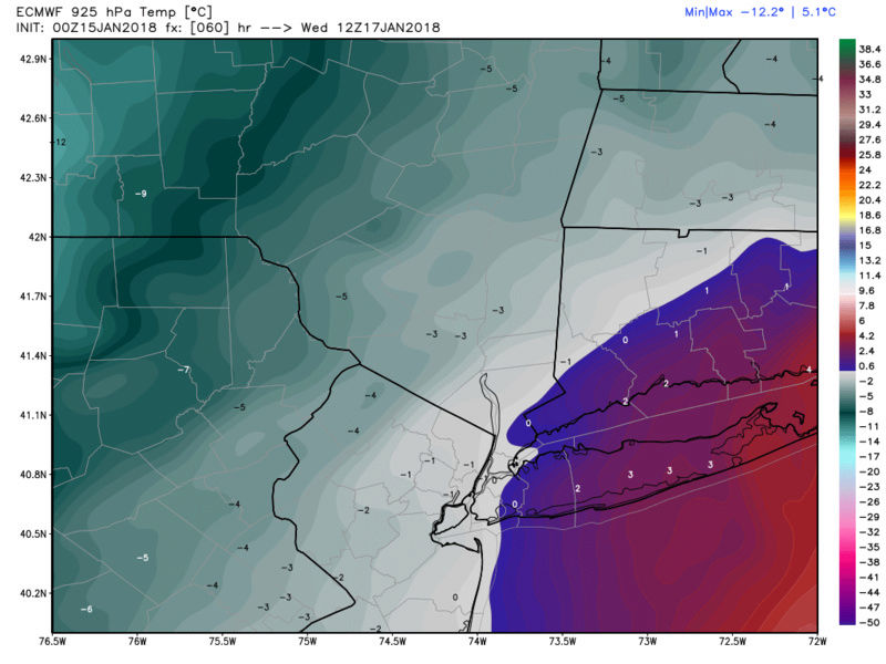
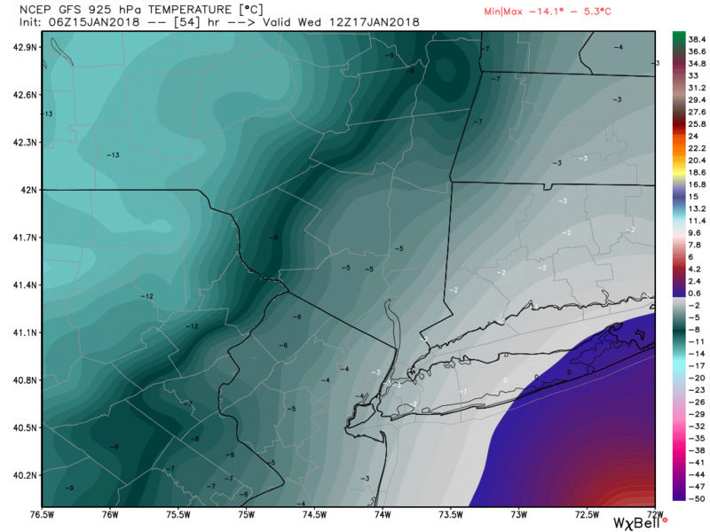
Frank LI esp east end needs to watch for mixing issues. There is a warm nose poking in at 925mb on most models. how far west is the question. Euro is the warmest, NAM coldest with GFS kind of inbetween, but leaning colder. Although you might be correct in that snow across the entire region is possible eastern sections must entertain this possibility of mixing; esp out by me.



_________________
"In weather and in life, there's no winning and losing; there's only winning and learning."
WINTER 2012/2013 TOTALS 43.65"WINTER 2017/2018 TOTALS 62.85" WINTER 2022/2023 TOTALS 4.9"
WINTER 2013/2014 TOTALS 64.85"WINTER 2018/2019 TOTALS 14.25" WINTER 2023/2024 TOTALS 13.1"
WINTER 2014/2015 TOTALS 71.20"WINTER 2019/2020 TOTALS 6.35"
WINTER 2015/2016 TOTALS 35.00"WINTER 2020/2021 TOTALS 37.75"
WINTER 2016/2017 TOTALS 42.25"WINTER 2021/2022 TOTALS 31.65"

sroc4- Admin

- Posts : 8354
Reputation : 302
Join date : 2013-01-07
Location : Wading River, LI
 Re: January 16th-17th Snow Event
Frank_Wx wrote:Good Morning,
As you likely heard by now we have some snow on the way beginning Tuesday afternoon through Wednesday morning. The GFS shows light snow falling from 2pm Tuesday to 10am Wednesday. It even tries to pop a coastal low to bring about moderate to heavy snow over portions of Long Island and southern New England. Surface temperatures look to be above freezing for the immediate coast, including NYC, but boundary temps are plentiful cold to support snow and not rain or mix. Due to the light intensity of the snow I am not expecting much accumulation on major roadways. Side roads and cold surfaces will get covered, however.
I am thinking 1-3 inches for SNJ, CNJ, and the Jersey Shore. 2-4 inches for LI, NYC, NE NJ. 3-6" is possible for NW NJ, N&W of NYC, and much of east-central and NE PA.
Start time likely to be 11am Tuesday (for NYC, earlier west) with an end time overnight Tuesday.
Frank, thanks for this new thread and the update!! Looks like the HV might get to 4 inches on this one.Elevation and ratio working for me on this one.

docstox12- Wx Statistician Guru

- Posts : 8530
Reputation : 222
Join date : 2013-01-07
Age : 73
Location : Monroe NY
 Re: January 16th-17th Snow Event
As long as it’s not sleet!

mikeypizano- Pro Enthusiast

- Posts : 1118
Reputation : 66
Join date : 2017-01-05
Age : 35
Location : Wilkes-Barre/Scranton, PA
 Re: January 16th-17th Snow Event
mikeypizano wrote:As long as it’s not sleet!
Mikey, how did you make out in the last storm? Aresian in west PA got 5.5 inches.

docstox12- Wx Statistician Guru

- Posts : 8530
Reputation : 222
Join date : 2013-01-07
Age : 73
Location : Monroe NY

aiannone- Senior Enthusiast - Mod

- Posts : 4815
Reputation : 92
Join date : 2013-01-07
Location : Saint James, LI (Northwest Suffolk Co.)

aiannone- Senior Enthusiast - Mod

- Posts : 4815
Reputation : 92
Join date : 2013-01-07
Location : Saint James, LI (Northwest Suffolk Co.)
 Re: January 16th-17th Snow Event
aiannone wrote:
Wow, much juicier for me in the HV! Maybe what Mugsy posted about JB's 4 to 8 is possible!

docstox12- Wx Statistician Guru

- Posts : 8530
Reputation : 222
Join date : 2013-01-07
Age : 73
Location : Monroe NY
 Re: January 16th-17th Snow Event
docstox12 wrote:aiannone wrote:
Wow, much juicier for me in the HV! Maybe what Mugsy posted about JB's 4 to 8 is possible!
From 33&Rain

_________________
Mugs
AKA:King: Snow Weenie
Self Proclaimed
WINTER 2014-15 : 55.12" +.02 for 6 coatings (avg. 35")
WINTER 2015-16 Total - 29.8" (Avg 35")
WINTER 2016-17 : 39.5" so far

amugs- Advanced Forecaster - Mod

- Posts : 15095
Reputation : 213
Join date : 2013-01-07
Age : 54
Location : Hillsdale,NJ
 Re: January 16th-17th Snow Event
3K NAM


_________________
Mugs
AKA:King: Snow Weenie
Self Proclaimed
WINTER 2014-15 : 55.12" +.02 for 6 coatings (avg. 35")
WINTER 2015-16 Total - 29.8" (Avg 35")
WINTER 2016-17 : 39.5" so far

amugs- Advanced Forecaster - Mod

- Posts : 15095
Reputation : 213
Join date : 2013-01-07
Age : 54
Location : Hillsdale,NJ
 Re: January 16th-17th Snow Event
Im confused sci says 17th but you guys are taking tomorrow and wed the 16th and 17th? I have drive back home from eastern CT tomorrow should I head back tonight or will the trip go ok?

jmanley32- Senior Enthusiast

- Posts : 20535
Reputation : 108
Join date : 2013-12-12
Age : 43
Location : Yonkers, NY
 Re: January 16th-17th Snow Event
I'll take that might be looking at a snow day in some places on wed no?amugs wrote:docstox12 wrote:aiannone wrote:
Wow, much juicier for me in the HV! Maybe what Mugsy posted about JB's 4 to 8 is possible!
From 33&Rain

jmanley32- Senior Enthusiast

- Posts : 20535
Reputation : 108
Join date : 2013-12-12
Age : 43
Location : Yonkers, NY
 Re: January 16th-17th Snow Event
jmanley32 wrote:Im confused sci says 17th but you guys are taking tomorrow and wed the 16th and 17th? I have drive back home from eastern CT tomorrow should I head back tonight or will the trip go ok?
Jman every time it’s supposed to snow you complain/ worry that you have to drive. Did you become a taxi driver or delivery Man? Anyway 3-6” over 12 hours will cause no issues while driving on the main roads. Warmiccist
Guest- Guest
 Re: January 16th-17th Snow Event
docstox12 wrote:mikeypizano wrote:As long as it’s not sleet!
Mikey, how did you make out in the last storm? Aresian in west PA got 5.5 inches.
About a half inch or so, maybe 3/4, of sleet mixed with a little snow. By noon, it was frozen solid...

mikeypizano- Pro Enthusiast

- Posts : 1118
Reputation : 66
Join date : 2017-01-05
Age : 35
Location : Wilkes-Barre/Scranton, PA
 Re: January 16th-17th Snow Event
I still think these totals are WAY overdone, and think a coating to 2", maybe 3" MAX is what results. It's a clipper - moisture-starved and quick.
rb924119- Meteorologist

- Posts : 6928
Reputation : 194
Join date : 2013-02-06
Age : 32
Location : Greentown, Pa
 Re: January 16th-17th Snow Event
rb924119 wrote:I still think these totals are WAY overdone, and think a coating to 2", maybe 3" MAX is what results. It's a clipper - moisture-starved and quick.
Ok you, back of the line!

mikeypizano- Pro Enthusiast

- Posts : 1118
Reputation : 66
Join date : 2017-01-05
Age : 35
Location : Wilkes-Barre/Scranton, PA
 Re: January 16th-17th Snow Event
Rb I have seen Clippers put down nothing and over perform. The nws in Albany seems to like the latter with a good 3-6 in my area will see.
jimv45- Senior Enthusiast

- Posts : 1168
Reputation : 36
Join date : 2013-09-20
Location : Hopewell jct.
 Re: January 16th-17th Snow Event
Also i am reading from the nws that its not just the clipper, it will be helped by the coastal to bring moderate snowfall. if they are right.
jimv45- Senior Enthusiast

- Posts : 1168
Reputation : 36
Join date : 2013-09-20
Location : Hopewell jct.
 Re: January 16th-17th Snow Event
rb924119 wrote:I still think these totals are WAY overdone, and think a coating to 2", maybe 3" MAX is what results. It's a clipper - moisture-starved and quick.
What about the low that most models have developing on the front? It's very possible this enhances the precip and gives Hudson valley 3-6. especially when most models show it snowing from Tuesday afternoon thru wednesday morning. I just checked NWS Albany snowfall forecast for the event and they have Poughkeepsie area getting 5 so it's a definite possibility.

hyde345- Pro Enthusiast

- Posts : 1082
Reputation : 48
Join date : 2013-01-08
Location : Hyde Park, NY
 Re: January 16th-17th Snow Event
WOW 12z GFS really develops the coastal low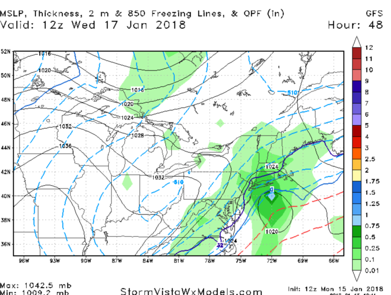

_________________
-Alex Iannone-

aiannone- Senior Enthusiast - Mod

- Posts : 4815
Reputation : 92
Join date : 2013-01-07
Location : Saint James, LI (Northwest Suffolk Co.)
 Re: January 16th-17th Snow Event
rb924119 wrote:I still think these totals are WAY overdone, and think a coating to 2", maybe 3" MAX is what results. It's a clipper - moisture-starved and quick.


RJB8525- Senior Enthusiast

- Posts : 1994
Reputation : 28
Join date : 2013-02-06
Age : 38
Location : Hackettstown, NJ
 Re: January 16th-17th Snow Event
Yea hyde that's what i am hearing, it looks good right now for a nice snowfall but again will see.
jimv45- Senior Enthusiast

- Posts : 1168
Reputation : 36
Join date : 2013-09-20
Location : Hopewell jct.
 Re: January 16th-17th Snow Event
hyde345 wrote:rb924119 wrote:I still think these totals are WAY overdone, and think a coating to 2", maybe 3" MAX is what results. It's a clipper - moisture-starved and quick.
What about the low that most models have developing on the front? It's very possible this enhances the precip and gives Hudson valley 3-6. especially when most models show it snowing from Tuesday afternoon thru wednesday morning. I just checked NWS Albany snowfall forecast for the event and they have Poughkeepsie area getting 5 so it's a definite possibility.
Where's the forcing for all of this? I certainly can't find any lol your H5 energy is way strung out and lagging the surface feature, and you have a rapidly decaying jet structure. Your main forcing mechanisms for deep vertical motion are entirely disjointed and/or weak/decaying. There's no way you're gonna get a half-foot of snow with all of your forcing for ascent coming from H7 and below lol there's nothing to expand the precip shield and draw it northwestward back into our area. It's gonna be concentrated around any low-level circulation, which even if it does develop is offshore. Snow showers and periods of light snow. No dendritic growth, just needles and columns, which don't rapidly accumulate. I just do not see this happening.
rb924119- Meteorologist

- Posts : 6928
Reputation : 194
Join date : 2013-02-06
Age : 32
Location : Greentown, Pa
 Re: January 16th-17th Snow Event
For fear of inciting riots and being banned to OTI with the title of Warmicist, I shall cease my actions and potentially law breaking actions of outcry against the establishment, and observe quietly until the event is over, whereby I will either be able to claim a small victory and condemn myself to hiding so I do not invite further riots out discontent for verification of my prediction. Or, if wrong, I shall admit to such and willfully accept any and all public humiliation and actions taken to mock me lmaooooo
rb924119- Meteorologist

- Posts : 6928
Reputation : 194
Join date : 2013-02-06
Age : 32
Location : Greentown, Pa
 Re: January 16th-17th Snow Event
rb924119 wrote:hyde345 wrote:rb924119 wrote:I still think these totals are WAY overdone, and think a coating to 2", maybe 3" MAX is what results. It's a clipper - moisture-starved and quick.
What about the low that most models have developing on the front? It's very possible this enhances the precip and gives Hudson valley 3-6. especially when most models show it snowing from Tuesday afternoon thru wednesday morning. I just checked NWS Albany snowfall forecast for the event and they have Poughkeepsie area getting 5 so it's a definite possibility.
Where's the forcing for all of this? I certainly can't find any lol your H5 energy is way strung out and lagging the surface feature, and you have a rapidly decaying jet structure. Your main forcing mechanisms for deep vertical motion are entirely disjointed and/or weak/decaying. There's no way you're gonna get a half-foot of snow with all of your forcing for ascent coming from H7 and below lol there's nothing to expand the precip shield and draw it northwestward back into our area. It's gonna be concentrated around any low-level circulation, which even if it does develop is offshore. Snow showers and periods of light snow. No dendritic growth, just needles and columns, which don't rapidly accumulate. I just do not see this happening.
Even without any additional enhancement this was still looking like a 1-3 inch type event. It won't take much to get us into 4-6 inch range plus it snows for around 18 hours. The 12z GFS, NAM, RGEM, CMC, all show HV getting around .50 liquid equivalent so they are indicating some forcing. When all models show this in this short time frame I'm going to say this is a very good sign especially for inland areas where temps won't be an issue.

hyde345- Pro Enthusiast

- Posts : 1082
Reputation : 48
Join date : 2013-01-08
Location : Hyde Park, NY
Page 1 of 15 • 1, 2, 3 ... 8 ... 15 
Page 1 of 15
Permissions in this forum:
You cannot reply to topics in this forum|
|
|

 Home
Home