
 Search
Long Range Thread 16.0
Page 6 of 34 •  1 ... 5, 6, 7 ... 20 ... 34
 ![]()
Re: Long Range Thread 16.0
![]() by Math23x7 Thu Feb 22, 2018 10:08 pm
by Math23x7 Thu Feb 22, 2018 10:08 pm
Dunnzoo wrote:ok, this is NOT funny! Going to Florida for spring training and it's going to be cool????
That's what a super negative AO/NAO couplet will do
Math23x7- Wx Statistician Guru

- Posts : 2379
Join date : 2013-01-08
Re: Long Range Thread 16.0
![]() by SnowForest Thu Feb 22, 2018 11:42 pm
by SnowForest Thu Feb 22, 2018 11:42 pm
SnowForest- Posts : 36
Join date : 2017-12-19
Re: Long Range Thread 16.0
![]() by WeatherBob Fri Feb 23, 2018 12:15 am
by WeatherBob Fri Feb 23, 2018 12:15 am

WeatherBob- Meteorologist

- Posts : 683
Reputation : 83
Join date : 2013-12-13
Location : Caldwell, NJ - NW Essex County - Altitude 500 FT
Re: Long Range Thread 16.0
![]() by jmanley32 Fri Feb 23, 2018 1:31 am
by jmanley32 Fri Feb 23, 2018 1:31 am
I have hit quite a few slot jackpots over the years so I will take those odds at this juncture LOLWeatherBob wrote:I don’t care what anyone says, this upcoming pattern is garbage. I will repeat with the same train of thought I said before, “round and round she goes, where the cut off lows develope , nobody knows”. You will have a better chance of hitting the jackpot on a slot machine than have a cut off low develop in the exact right spot to give us a bit hit.

jmanley32- Senior Enthusiast

- Posts : 20535
Reputation : 108
Join date : 2013-12-12
Age : 43
Location : Yonkers, NY
Re: Long Range Thread 16.0
![]() by sroc4 Fri Feb 23, 2018 7:52 am
by sroc4 Fri Feb 23, 2018 7:52 am
WeatherBob wrote:I don’t care what anyone says, this upcoming pattern is garbage. I will repeat with the same train of thought I said before, “round and round she goes, where the cut off lows develope , nobody knows”. You will have a better chance of hitting the jackpot on a slot machine than have a cut off low develop in the exact right spot to give us a bit hit.
Weather Bob I absolutely respect your opinion here but I am extremely perplexed as to how you can call the pattern Garbage? Is it absolutely textbook "perfect"? Of course not, but the pattern itself is certainly not garbage...IMHO of course.
Now as far as reliance on a cutoff low tracking perfectly is completely understood. The ability to predict the behavior of a cutoff low once its breaks off of the mean flow is shoddy at best, and I will absolutely agree with you on that; however, lets consider what is in the process of unfolding and will continue to unfold as we enter March. I am pretty sure regardless of any given stance on the situation we cant argue that an extremely anomalous rex block is setting up in the N Atlantic compliments of the -NAO ridge and a 50/50 cutoff low beneath it. The result of this is unquestionable; a log jam setting up off the Atlantic coast that will slow down the entire mean flow up stream. Up until this time frame this past month any time a short wave has tried to come across and develop the progressive flow (lack of blocking in the Atlantic and weak to mediocre western ridge amplification to the west), has prevented any any significant amplification of said s/w, and our cold air source, HP to our north, has been able to simply scoot east off the NE coast as the s/w approached shifting the mean wind flow for the area to the E/SE. The result was relying on cold air damning leaving us with these weak/marginal events. However, this wont be the case with the block in place.
With such a block in place and a split flow Pac pattern I would argue that the combination of a HP in place to the N, and confluence to the NE thanks to Atlantic blocking, we can relatively speaking, fairly accurately predict that the mean track of any cutoff low that develops in the heart of the CONUS would be to meander west to east and be forced or funneled somewhere off the midatlantic/NE coast instead of cut up into the GL like say what the GFS tried to do at 6z. Obv the details are still highly volatile this far out, but again IMHO the pattern is such that there WILL BE a storm for the MidAtlantic and/or NE, but who see what is the debate. Now can I say with 100% certainty that we wont see a cutoff push N through the block? No. But the likely hood of it bouncing off the block to the N as it tries to cut and be forced off the NE coast is MUCH higher and releatively easily to predict given the pattern.
Now I haven't even touched on the Pac pattern, but I believe although not perfect, is set up to only reinforce the idea of at least 1 probably 2, maybe three opportunities for significant snowfall for somewhere in the NE before Mid March(say 12th-15th). Beyond that it looks like our -NAO blocking is breaking down.
Here is a write up from Armando Salvatore on another site from last night. I really cant say it much better than this as this pretty much echos my thoughts, and does a great job describing the Pac patterns influence on the big picture. Again I cant stress enough that none of this guarantees anything, but the pattern is def set up to deliver here. I left off his images..sorry
Good evening everyone!
To sum up where we stand as of presently, and adding my thoughts, the period that has been discussed ad nauseam, will end up verifying (although pushed back yes, rather mid Feb, we see the alterations occur end of Feb into March). Anyhow, below for example, are the 12z EPS and most recent 18z GEFS 500mb anomalies. Going to bring up a few points here;
1. Between the 28th-5th, is where we see the "peak" of the onset/manifestation of the -NAO block. You can see just how anomalous it really is based off these ensemble packages.
2.This does bring about a serious tone to the sensible pattern over N.A., particularly the northeast because it's during these larger scale synoptic transitions, that bring about serious storms. However, this doesn't imply a guaranteed snowstorm, and much uncertainty exists, but the first period to watch is around March 2nd. How it all comes to be, again i reiterate - is ambiguous.
3. Following along these lines, when you scope out to garner what is happening, the entire flow is still slowly retrograding where the West Coast trough pulls back (shown all below via edits) and retracts, a ridge begins to build west into the Plains, all the while the west pacific begins to amplify via the jet stream. Right there and then, is A LOT for models to handle, so beware some crazy solutions being thrown out and still yet to come.
4. Now, i understand this will need to become redundant within itself, but read carefully(!); the first storm may not fully deliver the desired wants, BUT, it's right after where the pacific orients itself better AND the retrograding block weakens enough, to THEN allow a STRONGER and much more POTENT coastal storm (watching ~ 8th-10th) to amplify and deliver a nor'easter. Again, what is all transpiring is that trough off the west coast provides energy, and you also have a split flow (the pacific jet "splits" into two branches), so phasing opportunities come into light ALL underneath a block with a "jammed" Atlantic. Just allow the pattern to fully develop, then and only then, can we extrapolate and make sense of where this is heading in terms of impact. There WILL be more then one opportunity for a blockbuster snowstorm/major event and keep in mind, we look for the ONSET, THE INTERIM, AND THE DECAY of the -NAO for snow events
_________________
"In weather and in life, there's no winning and losing; there's only winning and learning."
WINTER 2012/2013 TOTALS 43.65"WINTER 2017/2018 TOTALS 62.85" WINTER 2022/2023 TOTALS 4.9"
WINTER 2013/2014 TOTALS 64.85"WINTER 2018/2019 TOTALS 14.25" WINTER 2023/2024 TOTALS 13.1"
WINTER 2014/2015 TOTALS 71.20"WINTER 2019/2020 TOTALS 6.35"
WINTER 2015/2016 TOTALS 35.00"WINTER 2020/2021 TOTALS 37.75"
WINTER 2016/2017 TOTALS 42.25"WINTER 2021/2022 TOTALS 31.65"

sroc4- Admin

- Posts : 8354
Reputation : 302
Join date : 2013-01-07
Location : Wading River, LI
Re: Long Range Thread 16.0
![]() by Scullybutcher Fri Feb 23, 2018 8:55 am
by Scullybutcher Fri Feb 23, 2018 8:55 am

Scullybutcher- Pro Enthusiast

- Posts : 543
Reputation : 16
Join date : 2013-02-06
Location : North Smithtown, western Suffolk county, long island
Re: Long Range Thread 16.0
![]() by WeatherBob Fri Feb 23, 2018 10:16 am
by WeatherBob Fri Feb 23, 2018 10:16 am
WeatherBob- Meteorologist
- Posts : 683
Reputation : 83
Join date : 2013-12-13
Location : Caldwell, NJ - NW Essex County - Altitude 500 FT
Re: Long Range Thread 16.0
![]() by sroc4 Fri Feb 23, 2018 11:09 am
by sroc4 Fri Feb 23, 2018 11:09 am
WeatherBob wrote:Keep up the good work sroc4! I am just normally pessimistic when it comes to large March storms. Even when you think everything sets up for a big one in the upper and mid levels, you always have to worry about the low level cold air being robust enough. We will see.
Thank you. And you bring up great points about the LLC. The airmass from which a system would draw from to the north is not exactly purely Siberian or arctic , but rather a mixture of polar and N Atlantic/Maritime so my thought is that its "cold enough", esp with a favorably positioned storm track.
Have I at least convinced you to change your idea of what this pattern is? Maybe go from a pattern that is "garbage" to maybe one that is say..."Do-Able"? LOL

_________________
"In weather and in life, there's no winning and losing; there's only winning and learning."
WINTER 2012/2013 TOTALS 43.65"WINTER 2017/2018 TOTALS 62.85" WINTER 2022/2023 TOTALS 4.9"
WINTER 2013/2014 TOTALS 64.85"WINTER 2018/2019 TOTALS 14.25" WINTER 2023/2024 TOTALS 13.1"
WINTER 2014/2015 TOTALS 71.20"WINTER 2019/2020 TOTALS 6.35"
WINTER 2015/2016 TOTALS 35.00"WINTER 2020/2021 TOTALS 37.75"
WINTER 2016/2017 TOTALS 42.25"WINTER 2021/2022 TOTALS 31.65"
sroc4- Admin
- Posts : 8354
Reputation : 302
Join date : 2013-01-07
Location : Wading River, LI
Re: Long Range Thread 16.0
![]() by MattyICE Fri Feb 23, 2018 11:24 am
by MattyICE Fri Feb 23, 2018 11:24 am
MattyICE- Advanced Forecaster

- Posts : 249
Reputation : 6
Join date : 2017-11-10
Age : 38
Location : Clifton, NJ (Eastern Passaic County)
Re: Long Range Thread 16.0
![]() by sroc4 Fri Feb 23, 2018 11:27 am
by sroc4 Fri Feb 23, 2018 11:27 am
MattyICE wrote:Despite the block, the GFS not only CUTS the LP next week...but literally into IOWA?? I need someone smarter than me to explain this.
The simplest explanation is usually the correct one...its confused.
_________________
"In weather and in life, there's no winning and losing; there's only winning and learning."
WINTER 2012/2013 TOTALS 43.65"WINTER 2017/2018 TOTALS 62.85" WINTER 2022/2023 TOTALS 4.9"
WINTER 2013/2014 TOTALS 64.85"WINTER 2018/2019 TOTALS 14.25" WINTER 2023/2024 TOTALS 13.1"
WINTER 2014/2015 TOTALS 71.20"WINTER 2019/2020 TOTALS 6.35"
WINTER 2015/2016 TOTALS 35.00"WINTER 2020/2021 TOTALS 37.75"
WINTER 2016/2017 TOTALS 42.25"WINTER 2021/2022 TOTALS 31.65"
sroc4- Admin
- Posts : 8354
Reputation : 302
Join date : 2013-01-07
Location : Wading River, LI
Re: Long Range Thread 16.0
![]() by WeatherBob Fri Feb 23, 2018 11:40 am
by WeatherBob Fri Feb 23, 2018 11:40 am
WeatherBob- Meteorologist
- Posts : 683
Reputation : 83
Join date : 2013-12-13
Location : Caldwell, NJ - NW Essex County - Altitude 500 FT
Re: Long Range Thread 16.0
![]() by amugs Sat Feb 24, 2018 8:33 am
by amugs Sat Feb 24, 2018 8:33 am
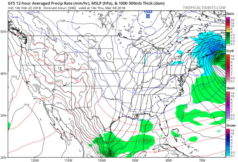
This is a great set up depicted by the Euro and IF this were to verify as I told my students yesterday we can be measuring in feet the first 10-12 days of March!!!

There is plenty of cold air still to the North that these beasts can tap at this time. And this is the GFS

CMC

_________________
Mugs
AKA:King: Snow Weenie
Self Proclaimed
WINTER 2014-15 : 55.12" +.02 for 6 coatings (avg. 35")
WINTER 2015-16 Total - 29.8" (Avg 35")
WINTER 2016-17 : 39.5" so far

amugs- Advanced Forecaster - Mod

- Posts : 15095
Reputation : 213
Join date : 2013-01-07
Age : 54
Location : Hillsdale,NJ
Re: Long Range Thread 16.0
![]() by sroc4 Sat Feb 24, 2018 9:34 am
by sroc4 Sat Feb 24, 2018 9:34 am
_________________
"In weather and in life, there's no winning and losing; there's only winning and learning."
WINTER 2012/2013 TOTALS 43.65"WINTER 2017/2018 TOTALS 62.85" WINTER 2022/2023 TOTALS 4.9"
WINTER 2013/2014 TOTALS 64.85"WINTER 2018/2019 TOTALS 14.25" WINTER 2023/2024 TOTALS 13.1"
WINTER 2014/2015 TOTALS 71.20"WINTER 2019/2020 TOTALS 6.35"
WINTER 2015/2016 TOTALS 35.00"WINTER 2020/2021 TOTALS 37.75"
WINTER 2016/2017 TOTALS 42.25"WINTER 2021/2022 TOTALS 31.65"
sroc4- Admin
- Posts : 8354
Reputation : 302
Join date : 2013-01-07
Location : Wading River, LI
Re: Long Range Thread 16.0
![]() by Guest Sat Feb 24, 2018 11:36 am
by Guest Sat Feb 24, 2018 11:36 am
Guest- Guest
Re: Long Range Thread 16.0
![]() by GreyBeard Sat Feb 24, 2018 12:25 pm
by GreyBeard Sat Feb 24, 2018 12:25 pm
sroc4 wrote:Do not be surprised to actually see our first threat of snow to happen before we end Feb. Feb 26-29th. It may start with a cutter that sets up the 50/50 low around the 25th-27th followed by a Miller B type system shortly after
With temps forecast to be in the low to mid 50's Monday thru Wednesday, I would be very surprised to see this verify.
GreyBeard- Senior Enthusiast
- Posts : 725
Reputation : 34
Join date : 2014-02-12
Location : eastern nassau county
Re: Long Range Thread 16.0
![]() by algae888 Sat Feb 24, 2018 12:41 pm
by algae888 Sat Feb 24, 2018 12:41 pm
Well Scott today's model runs show the primary low over Chicago and the secondary forming right on top of us. Not a good scenario would be mostly rain with maybe some back-end snows. What we need is for the primary to be further east or maybe a little south of East and the secondary form off The Jersey coast and bomb out there. That would be rain too heavy wet snow something similar to Christmas Day 2004 or 5 I can't remember the exact year. there are two ways this could happen one if the Greenland block moves in faster than currently modeled which would force everything south or two which is more likely that the primary low pressure is slower and allows the block to establish itself which would force everything South. We only need a 100 to 200-mile swing in 6 days definitely not impossible let's see what the Euro shows and how the rest of the weekend modeling unfoldssroc4 wrote:Obviously we still have a long way to go to see how it all plays out but the first storm around the 2nd is starting to take shape. For now we cont to monitor the big picture as only minor shifts in the upper levels will lead to huge shifts in the lower and mid levels solns. For better or worse. Still A few days away before We can look at the real details with any confidence.

algae888- Advanced Forecaster
- Posts : 5311
Reputation : 46
Join date : 2013-02-05
Age : 62
Location : mt. vernon, new york
Re: Long Range Thread 16.0
![]() by algae888 Sat Feb 24, 2018 12:47 pm
by algae888 Sat Feb 24, 2018 12:47 pm
algae888- Advanced Forecaster
- Posts : 5311
Reputation : 46
Join date : 2013-02-05
Age : 62
Location : mt. vernon, new york
Re: Long Range Thread 16.0
![]() by algae888 Sat Feb 24, 2018 1:27 pm
by algae888 Sat Feb 24, 2018 1:27 pm
algae888- Advanced Forecaster
- Posts : 5311
Reputation : 46
Join date : 2013-02-05
Age : 62
Location : mt. vernon, new york
Re: Long Range Thread 16.0
![]() by sroc4 Sat Feb 24, 2018 1:56 pm
by sroc4 Sat Feb 24, 2018 1:56 pm
algae888 wrote:Well Scott today's model runs show the primary low over Chicago and the secondary forming right on top of us. Not a good scenario would be mostly rain with maybe some back-end snows. What we need is for the primary to be further east or maybe a little south of East and the secondary form off The Jersey coast and bomb out there. That would be rain too heavy wet snow something similar to Christmas Day 2004 or 5 I can't remember the exact year. there are two ways this could happen one if the Greenland block moves in faster than currently modeled which would force everything south or two which is more likely that the primary low pressure is slower and allows the block to establish itself which would force everything South. We only need a 100 to 200-mile swing in 6 days definitely not impossible let's see what the Euro shows and how the rest of the weekend modeling unfoldssroc4 wrote:Obviously we still have a long way to go to see how it all plays out but the first storm around the 2nd is starting to take shape. For now we cont to monitor the big picture as only minor shifts in the upper levels will lead to huge shifts in the lower and mid levels solns. For better or worse. Still A few days away before We can look at the real details with any confidence.
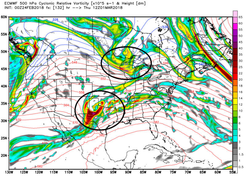
Models are still completely lost on where, when, and how strong all the energy is at 18,000 feet. Here is 00z Euro vs today 12z. Notice how yesterday it kept the N piece and S piece separate vs today it phased too early forcing the primary to cut way west. Combine this with the timing and positioning of the NAO block backing west and the 50/50 low and there is still a ton for models to resolve. A strong primary cutting west followed by a transfer to far to the N is def a possibility, but if anyone out there thinks its signed sealed delivered your wrong. Give it a few days.

_________________
"In weather and in life, there's no winning and losing; there's only winning and learning."
WINTER 2012/2013 TOTALS 43.65"WINTER 2017/2018 TOTALS 62.85" WINTER 2022/2023 TOTALS 4.9"
WINTER 2013/2014 TOTALS 64.85"WINTER 2018/2019 TOTALS 14.25" WINTER 2023/2024 TOTALS 13.1"
WINTER 2014/2015 TOTALS 71.20"WINTER 2019/2020 TOTALS 6.35"
WINTER 2015/2016 TOTALS 35.00"WINTER 2020/2021 TOTALS 37.75"
WINTER 2016/2017 TOTALS 42.25"WINTER 2021/2022 TOTALS 31.65"
sroc4- Admin
- Posts : 8354
Reputation : 302
Join date : 2013-01-07
Location : Wading River, LI
Re: Long Range Thread 16.0
![]() by algae888 Sat Feb 24, 2018 2:37 pm
by algae888 Sat Feb 24, 2018 2:37 pm
algae888- Advanced Forecaster
- Posts : 5311
Reputation : 46
Join date : 2013-02-05
Age : 62
Location : mt. vernon, new york
Re: Long Range Thread 16.0
![]() by amugs Sat Feb 24, 2018 4:43 pm
by amugs Sat Feb 24, 2018 4:43 pm
algae888 wrote:Yes Scott way too early to write this off I really believe this is coming south with such a strong Greenland block GEFS are definitely South and I'm also hearing the EPS is South as well
EPS for you Al and people writing anything off need to go to OTI for sometime. The atmospheric mechanisms are not even being recognized by the models - look at Europe and the UK? They had the pattern way under modeled 4 days ago to what is about to happen storm wise and cold wise.

_________________
Mugs
AKA:King: Snow Weenie
Self Proclaimed
WINTER 2014-15 : 55.12" +.02 for 6 coatings (avg. 35")
WINTER 2015-16 Total - 29.8" (Avg 35")
WINTER 2016-17 : 39.5" so far
amugs- Advanced Forecaster - Mod
- Posts : 15095
Reputation : 213
Join date : 2013-01-07
Age : 54
Location : Hillsdale,NJ
Re: Long Range Thread 16.0
![]() by CPcantmeasuresnow Sat Feb 24, 2018 6:25 pm
by CPcantmeasuresnow Sat Feb 24, 2018 6:25 pm
amugs wrote:algae888 wrote:Yes Scott way too early to write this off I really believe this is coming south with such a strong Greenland block GEFS are definitely South and I'm also hearing the EPS is South as well
EPS for you Al and people writing anything off need to go to OTI for sometime. The atmospheric mechanisms are not even being recognized by the models - look at Europe and the UK? They had the pattern way under modeled 4 days ago to what is about to happen storm wise and cold wise.
I'm tingling just looking at that.

CPcantmeasuresnow- Wx Statistician Guru
- Posts : 7274
Reputation : 230
Join date : 2013-01-07
Age : 103
Location : Eastern Orange County, NY
Re: Long Range Thread 16.0
![]() by dkodgis Sat Feb 24, 2018 9:31 pm
by dkodgis Sat Feb 24, 2018 9:31 pm

dkodgis- Senior Enthusiast
- Posts : 2560
Reputation : 98
Join date : 2013-12-29
Re: Long Range Thread 16.0
![]() by jmanley32 Sat Feb 24, 2018 10:45 pm
by jmanley32 Sat Feb 24, 2018 10:45 pm
I helped a little reverse psych, I had shovel in my car i brought it in and put it away yaydkodgis wrote:I checked with NWS for the week's forecast and I saw for this Friday: "Snow likely." <---Yeah! Everything's coming up roses. The stars are aligning. All great minds are thinking alike. Locate your shovels.
jmanley32- Senior Enthusiast
- Posts : 20535
Reputation : 108
Join date : 2013-12-12
Age : 43
Location : Yonkers, NY
Re: Long Range Thread 16.0
![]() by jmanley32 Sat Feb 24, 2018 10:49 pm
by jmanley32 Sat Feb 24, 2018 10:49 pm
That looks very nice, any of those ones along the shore pan out though and its all rain, hopefully more will shift south. I am not writing anything off, this seems to be a very complex setup we havent had this year ( a shame) and therefore I believe the models are far from a solution. I start the new job Monday and being that I will be working intensively with the kids and not even allowed to have my cell in the classroom I will not know much until 3:15, maybe at 2pm when the kids go home and we do our paperwork and statistics for the day.CPcantmeasuresnow wrote:amugs wrote:algae888 wrote:Yes Scott way too early to write this off I really believe this is coming south with such a strong Greenland block GEFS are definitely South and I'm also hearing the EPS is South as well
EPS for you Al and people writing anything off need to go to OTI for sometime. The atmospheric mechanisms are not even being recognized by the models - look at Europe and the UK? They had the pattern way under modeled 4 days ago to what is about to happen storm wise and cold wise.
I'm tingling just looking at that.
jmanley32- Senior Enthusiast
- Posts : 20535
Reputation : 108
Join date : 2013-12-12
Age : 43
Location : Yonkers, NY
Re: Long Range Thread 16.0
![]() by Grselig Sat Feb 24, 2018 11:03 pm
by Grselig Sat Feb 24, 2018 11:03 pm
jmanley32 wrote:That looks very nice, any of those ones along the shore pan out though and its all rain, hopefully more will shift south. I am not writing anything off, this seems to be a very complex setup we havent had this year ( a shame) and therefore I believe the models are far from a solution. I start the new job Monday and being that I will be working intensively with the kids and not even allowed to have my cell in the classroom I will not know much until 3:15, maybe at 2pm when the kids go home and we do our paperwork and statistics for the day.CPcantmeasuresnow wrote:amugs wrote:algae888 wrote:Yes Scott way too early to write this off I really believe this is coming south with such a strong Greenland block GEFS are definitely South and I'm also hearing the EPS is South as well
EPS for you Al and people writing anything off need to go to OTI for sometime. The atmospheric mechanisms are not even being recognized by the models - look at Europe and the UK? They had the pattern way under modeled 4 days ago to what is about to happen storm wise and cold wise.
I'm tingling just looking at that.
JMan Congrats and best of luck. I have a feeling you are going to make a difference in kids lives!!!! They need people like you.

Grselig- Senior Enthusiast
- Posts : 1408
Reputation : 140
Join date : 2013-03-04
Age : 54
Location : Wayne NJ
Re: Long Range Thread 16.0
![]() by jmanley32 Sat Feb 24, 2018 11:21 pm
by jmanley32 Sat Feb 24, 2018 11:21 pm
Thanks as I had stated earlier in the week its a preschool so the goal is to get them ready to move into kindergarten. Most have developmental delays such as autism spectrum disorder and this school with uses something called applied behavioral analysis as their methodology to help them supposedly learn 4-7x faster than those that are not given early intervention. I am very interested to take this change in career paths though it is still very much social work related its more of a teaching job but still requires my NYS LMSW and credentials.Grselig wrote:jmanley32 wrote:That looks very nice, any of those ones along the shore pan out though and its all rain, hopefully more will shift south. I am not writing anything off, this seems to be a very complex setup we havent had this year ( a shame) and therefore I believe the models are far from a solution. I start the new job Monday and being that I will be working intensively with the kids and not even allowed to have my cell in the classroom I will not know much until 3:15, maybe at 2pm when the kids go home and we do our paperwork and statistics for the day.CPcantmeasuresnow wrote:amugs wrote:algae888 wrote:Yes Scott way too early to write this off I really believe this is coming south with such a strong Greenland block GEFS are definitely South and I'm also hearing the EPS is South as well
EPS for you Al and people writing anything off need to go to OTI for sometime. The atmospheric mechanisms are not even being recognized by the models - look at Europe and the UK? They had the pattern way under modeled 4 days ago to what is about to happen storm wise and cold wise.
I'm tingling just looking at that.
JMan Congrats and best of luck. I have a feeling you are going to make a difference in kids lives!!!! They need people like you.
jmanley32- Senior Enthusiast
- Posts : 20535
Reputation : 108
Join date : 2013-12-12
Age : 43
Location : Yonkers, NY
Page 6 of 34 • 1 ... 5, 6, 7 ... 20 ... 34 ![]()
|
|
|