
 Search
Long Range Thread 16.0
Page 5 of 34 •  1, 2, 3, 4, 5, 6 ... 19 ... 34
 ![]()
Re: Long Range Thread 16.0
![]() by sroc4 Tue Feb 20, 2018 4:44 pm
by sroc4 Tue Feb 20, 2018 4:44 pm
track17 wrote:Carter bk wrote:Cant see nyc getting under the freezing mark during daytime the rest of season
Wait you have me real confused. All of our experts here are saying that we have a chance for cold conditions. Are you seeing something they are not. I am not trying to judge or saying you wrong and they are right just asking why you think this. It is the opposite of what they said. If you or one of are experts can chime in it owuod be great. I am not as smart as other but as of this morning I was pumped for march being cold now your saying the opposite.
Track. All he/she said was that they didn't think NYC doesn't get below freezing as a daytime high for the rest of the season. This does not mean it wont be cold and snowy. Average high temp for NYC on todays date is already 41*. Avg high temp on March 1st is 43* in NYC. That means we need an air mass to provide -11*F departures from normal to achieve a 32* high temp for NYC as of March 1st. By March 7th the avg high is already 45*f meaning a -13 departure from normal is needed to achieve freezing or below freezing daytime High temp. Bottom line is Odds are it will be very difficult to achieve a daytime High at or below freezing forr the rest of the season since the pattern isnt going to support below normal temp departures for about another 5-7days at least.
However; A high temp of 35* on March first would be an 8 degree departure from normal which would be significantly cold relative to the time of year yet would still agree with Carters statement. This doesn't mean it cant snow. So be careful not to misinterpret what some of us are saying about the pattern in front of us. I personally have not mentioned anything about what temps will actually be going forward except to say that the pattern is headed to one that will allow for big snow storms to develop. As we enter March the pattern will allow for below normal temp departures overall, but this doesn't have to mean that a high temp below freezing in NYC will happen, nor does it mean we cant also have a day or two with above normal temps.
Trust me when I tell you there will be at least one BIG storm, wide spread Godzilla or better potential, before all is said and done, but don't think the details of said storm(s) means everyone gets in on the action. Those details will be ironed out inside 3-5days.
When someone makes a general statement like what was said above I wouldn't think much about it without them explaining why.
sroc4- Admin

- Posts : 8354
Join date : 2013-01-07
Re: Long Range Thread 16.0
![]() by WeatherBob Tue Feb 20, 2018 4:49 pm
by WeatherBob Tue Feb 20, 2018 4:49 pm
WeatherBob- Meteorologist

- Posts : 683
Join date : 2013-12-13
Re: Long Range Thread 16.0
![]() by sroc4 Tue Feb 20, 2018 5:31 pm
by sroc4 Tue Feb 20, 2018 5:31 pm
We haven’t had this kind of blocking in years. Obv it’s still a ways away so it’s all contingent on the block setting up but there is nothing leading to believe it won’t at the moment.
_________________
"In weather and in life, there's no winning and losing; there's only winning and learning."
WINTER 2012/2013 TOTALS 43.65"WINTER 2017/2018 TOTALS 62.85" WINTER 2022/2023 TOTALS 4.9"
WINTER 2013/2014 TOTALS 64.85"WINTER 2018/2019 TOTALS 14.25" WINTER 2023/2024 TOTALS 13.1"
WINTER 2014/2015 TOTALS 71.20"WINTER 2019/2020 TOTALS 6.35"
WINTER 2015/2016 TOTALS 35.00"WINTER 2020/2021 TOTALS 37.75"
WINTER 2016/2017 TOTALS 42.25"WINTER 2021/2022 TOTALS 31.65"

sroc4- Admin
- Posts : 8354
Reputation : 302
Join date : 2013-01-07
Location : Wading River, LI
Re: Long Range Thread 16.0
![]() by sroc4 Tue Feb 20, 2018 5:35 pm
by sroc4 Tue Feb 20, 2018 5:35 pm
_________________
"In weather and in life, there's no winning and losing; there's only winning and learning."
WINTER 2012/2013 TOTALS 43.65"WINTER 2017/2018 TOTALS 62.85" WINTER 2022/2023 TOTALS 4.9"
WINTER 2013/2014 TOTALS 64.85"WINTER 2018/2019 TOTALS 14.25" WINTER 2023/2024 TOTALS 13.1"
WINTER 2014/2015 TOTALS 71.20"WINTER 2019/2020 TOTALS 6.35"
WINTER 2015/2016 TOTALS 35.00"WINTER 2020/2021 TOTALS 37.75"
WINTER 2016/2017 TOTALS 42.25"WINTER 2021/2022 TOTALS 31.65"
sroc4- Admin
- Posts : 8354
Reputation : 302
Join date : 2013-01-07
Location : Wading River, LI
Re: Long Range Thread 16.0
![]() by track17 Tue Feb 20, 2018 6:26 pm
by track17 Tue Feb 20, 2018 6:26 pm
track17- Posts : 454
Reputation : 4
Join date : 2016-01-09
Re: Long Range Thread 16.0
![]() by jmanley32 Wed Feb 21, 2018 2:24 am
by jmanley32 Wed Feb 21, 2018 2:24 am
sroc theres 28 days this year : ) So if theres going to be anything happening February 29th its going to be in another dimension lolsroc4 wrote:Do not be surprised to actually see our first threat of snow to happen before we end Feb. Feb 26-29th. It may start with a cutter that sets up the 50/50 low around the 25th-27th followed by a Miller B type system shortly after

jmanley32- Senior Enthusiast

- Posts : 20535
Reputation : 108
Join date : 2013-12-12
Age : 43
Location : Yonkers, NY
Re: Long Range Thread 16.0
![]() by Snow88 Wed Feb 21, 2018 9:56 am
by Snow88 Wed Feb 21, 2018 9:56 am
WeatherBob wrote:I do not see a big storm with this pattern developing for the first 2 weeks of March. Seems like a pattern of random cut- off lows will be the rule. Unless you get that cut off develope over Virginia and move east or east northeast with a surface low on the coast, yes , the storm will be there. However, with the developing pattern, you have better odds at hitting a jackpot on a slot machine than seeing the storm I just mentioned happening. Just my humble opinion.
Storms will not be able to cut with the block
They will be forced to redevelop

Snow88- Senior Enthusiast
- Posts : 2193
Reputation : 4
Join date : 2013-01-09
Age : 35
Location : Brooklyn, NY
Re: Long Range Thread 16.0
![]() by Snow88 Wed Feb 21, 2018 9:57 am
by Snow88 Wed Feb 21, 2018 9:57 am
sroc4 wrote:Do not be surprised to actually see our first threat of snow to happen before we end Feb. Feb 26-29th. It may start with a cutter that sets up the 50/50 low around the 25th-27th followed by a Miller B type system shortly after
I agree
The end of the month into the 1st week of March holds a lot of promise for a big slow moving storm.
Snow88- Senior Enthusiast
- Posts : 2193
Reputation : 4
Join date : 2013-01-09
Age : 35
Location : Brooklyn, NY
Re: Long Range Thread 16.0
![]() by Frank_Wx Wed Feb 21, 2018 9:59 am
by Frank_Wx Wed Feb 21, 2018 9:59 am
_________________
_______________________________________________________________________________________________________
CLICK HERE to view NJ Strong Snowstorm Classifications

Frank_Wx- Godzilla Seeker
- Posts : 21305
Reputation : 328
Join date : 2013-01-05
Age : 32
Location : Jersey City, NJ -

Re: Long Range Thread 16.0
![]() by Snow88 Wed Feb 21, 2018 10:12 am
by Snow88 Wed Feb 21, 2018 10:12 am
More
According to our definition of the NAO, models are calling for the all-time strongest -NAO value observed since our archive (beginning in 1980). The record low value since 1980 is from February 2006 (-2.77sigma). We are seeing models call for -3sigma during late February 2018.
Snow88- Senior Enthusiast
- Posts : 2193
Reputation : 4
Join date : 2013-01-09
Age : 35
Location : Brooklyn, NY
Re: Long Range Thread 16.0
![]() by WeatherBob Wed Feb 21, 2018 10:25 am
by WeatherBob Wed Feb 21, 2018 10:25 am

WeatherBob- Meteorologist
- Posts : 683
Reputation : 83
Join date : 2013-12-13
Location : Caldwell, NJ - NW Essex County - Altitude 500 FT
Re: Long Range Thread 16.0
![]() by WeatherBob Wed Feb 21, 2018 2:31 pm
by WeatherBob Wed Feb 21, 2018 2:31 pm
WeatherBob- Meteorologist
- Posts : 683
Reputation : 83
Join date : 2013-12-13
Location : Caldwell, NJ - NW Essex County - Altitude 500 FT
Re: Long Range Thread 16.0
![]() by Carter bk Wed Feb 21, 2018 8:37 pm
by Carter bk Wed Feb 21, 2018 8:37 pm
Carter bk- Posts : 73
Reputation : 5
Join date : 2017-12-07
Re: Long Range Thread 16.0
![]() by jmanley32 Wed Feb 21, 2018 11:29 pm
by jmanley32 Wed Feb 21, 2018 11:29 pm
he posted just a bit back on this page scroll up.Carter bk wrote:Where is frank any updates on long range that add more credit to at lease a cooler pattern and maybe snowy
jmanley32- Senior Enthusiast
- Posts : 20535
Reputation : 108
Join date : 2013-12-12
Age : 43
Location : Yonkers, NY
Re: Long Range Thread 16.0
![]() by dkodgis Thu Feb 22, 2018 3:12 am
by dkodgis Thu Feb 22, 2018 3:12 am

dkodgis- Senior Enthusiast
- Posts : 2560
Reputation : 98
Join date : 2013-12-29
Re: Long Range Thread 16.0
![]() by sroc4 Thu Feb 22, 2018 7:10 am
by sroc4 Thu Feb 22, 2018 7:10 am
Frank_Wx wrote:Quite the blocking pattern setting up in the long range. I would not be shocked if we saw another snow event occur in March. At the least, we're likely to see below normal temperatures the first 10 days of March. Of course the -NAO wants to develop as we exit Meteorological Winter. This is what happens when a SSWE occurs too late in the season. Our springs start off on the cold side!
Believe who you want to believe
_________________
"In weather and in life, there's no winning and losing; there's only winning and learning."
WINTER 2012/2013 TOTALS 43.65"WINTER 2017/2018 TOTALS 62.85" WINTER 2022/2023 TOTALS 4.9"
WINTER 2013/2014 TOTALS 64.85"WINTER 2018/2019 TOTALS 14.25" WINTER 2023/2024 TOTALS 13.1"
WINTER 2014/2015 TOTALS 71.20"WINTER 2019/2020 TOTALS 6.35"
WINTER 2015/2016 TOTALS 35.00"WINTER 2020/2021 TOTALS 37.75"
WINTER 2016/2017 TOTALS 42.25"WINTER 2021/2022 TOTALS 31.65"
sroc4- Admin
- Posts : 8354
Reputation : 302
Join date : 2013-01-07
Location : Wading River, LI
Re: Long Range Thread 16.0
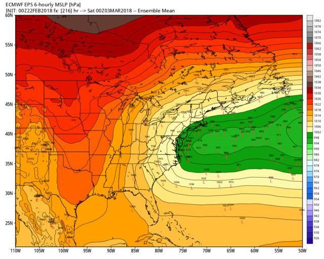
![]() by Snow88 Thu Feb 22, 2018 9:57 am
by Snow88 Thu Feb 22, 2018 9:57 am
Threat gradually increasing for a coastal storm during the first 4 days of March:
Snow88- Senior Enthusiast
- Posts : 2193
Reputation : 4
Join date : 2013-01-09
Age : 35
Location : Brooklyn, NY
Re: Long Range Thread 16.0
![]() by Snow88 Thu Feb 22, 2018 10:07 am
by Snow88 Thu Feb 22, 2018 10:07 am
The front end time of blocks, esp after a very warm pattern, normally favor interior and New England. But this storm later next week comes at the peak of the block's retrograde, not necessarily its start. That's what 1962 did as well, as an extreme example.
Snow88- Senior Enthusiast
- Posts : 2193
Reputation : 4
Join date : 2013-01-09
Age : 35
Location : Brooklyn, NY
Re: Long Range Thread 16.0
![]() by Frank_Wx Thu Feb 22, 2018 10:13 am
by Frank_Wx Thu Feb 22, 2018 10:13 am
_________________
_______________________________________________________________________________________________________
CLICK HERE to view NJ Strong Snowstorm Classifications
Frank_Wx- Godzilla Seeker
- Posts : 21305
Reputation : 328
Join date : 2013-01-05
Age : 32
Location : Jersey City, NJ -

skinsfan1177- Senior Enthusiast
- Posts : 4485
Reputation : 35
Join date : 2013-01-07
Age : 46
Location : Point Pleasant Boro
Re: Long Range Thread 16.0
![]() by CPcantmeasuresnow Thu Feb 22, 2018 10:41 am
by CPcantmeasuresnow Thu Feb 22, 2018 10:41 am
skinsfan1177 wrote:Looks impressive
I'd say it looks confused more than anything, with impressive potential.

CPcantmeasuresnow- Wx Statistician Guru

- Posts : 7274
Reputation : 230
Join date : 2013-01-07
Age : 103
Location : Eastern Orange County, NY
Re: Long Range Thread 16.0
![]() by skinsfan1177 Thu Feb 22, 2018 11:50 am
by skinsfan1177 Thu Feb 22, 2018 11:50 am
CPcantmeasuresnow wrote:skinsfan1177 wrote:Looks impressive
I'd say it looks confused more than anything, with impressive potential.
Impressive this far out
skinsfan1177- Senior Enthusiast
- Posts : 4485
Reputation : 35
Join date : 2013-01-07
Age : 46
Location : Point Pleasant Boro
Re: Long Range Thread 16.0
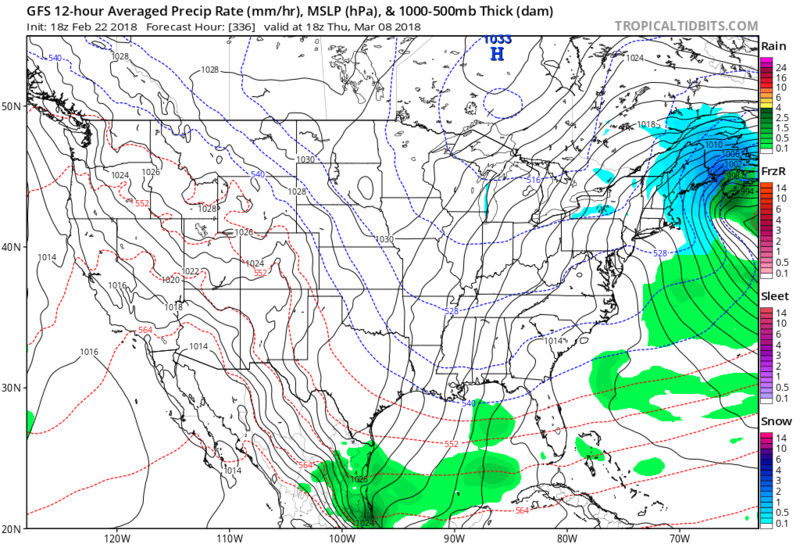
![]() by amugs Thu Feb 22, 2018 4:46 pm
by amugs Thu Feb 22, 2018 4:46 pm

Compliments of Dougie fresh
_________________
Mugs
AKA:King: Snow Weenie
Self Proclaimed
WINTER 2014-15 : 55.12" +.02 for 6 coatings (avg. 35")
WINTER 2015-16 Total - 29.8" (Avg 35")
WINTER 2016-17 : 39.5" so far

amugs- Advanced Forecaster - Mod

- Posts : 15095
Reputation : 213
Join date : 2013-01-07
Age : 54
Location : Hillsdale,NJ
Re: Long Range Thread 16.0
![]() by CPcantmeasuresnow Thu Feb 22, 2018 5:04 pm
by CPcantmeasuresnow Thu Feb 22, 2018 5:04 pm
amugs wrote:This is a sick run, the LP can't go anywhwre due to the massive blockade in the North Atlantic. Look at what is does. Just for showing if we get an LP to slip unflderneath with a split flow from the PAC and some STJ love this is a sceneries that us not out of the question. Please no wah wah NE gets crushed just showing the potential here. Runs will be inasneasier the next few days as they starts to see the enermoity of the block sething up over head.
Compliments of Dougie fresh
WOW!!!!!!! Blizzard of 1888 type track. Who's snow, who's rain, does it happen at all, OTS, a rain storm for all? as Mugs says it's out but it's a long way off, but again WOW.
Some similarities in path also to the Snowicane of Feb 25-26 2010. 21 inches in NYC from that 35 inches IMBY and all rain in Red Sox Suck. Def worth keeping an eye on.
CPcantmeasuresnow- Wx Statistician Guru
- Posts : 7274
Reputation : 230
Join date : 2013-01-07
Age : 103
Location : Eastern Orange County, NY
Re: Long Range Thread 16.0
![]() by Dunnzoo Thu Feb 22, 2018 6:12 pm
by Dunnzoo Thu Feb 22, 2018 6:12 pm
_________________
Janet
Snowfall winter of 2023-2024 17.5"
Snowfall winter of 2022-2023 6.0"
Snowfall winter of 2021-2022 17.6" 1" sleet 2/25/22
Snowfall winter of 2020-2021 51.1"
Snowfall winter of 2019-2020 8.5"
Snowfall winter of 2018-2019 25.1"
Snowfall winter of 2017-2018 51.9"
Snowfall winter of 2016-2017 45.6"
Snowfall winter of 2015-2016 29.5"
Snowfall winter of 2014-2015 50.55"
Snowfall winter of 2013-2014 66.5"

Dunnzoo- Senior Enthusiast - Mod
- Posts : 4904
Reputation : 68
Join date : 2013-01-11
Age : 62
Location : Westwood, NJ
Re: Long Range Thread 16.0
![]() by Math23x7 Thu Feb 22, 2018 10:08 pm
by Math23x7 Thu Feb 22, 2018 10:08 pm
Dunnzoo wrote:ok, this is NOT funny! Going to Florida for spring training and it's going to be cool????
That's what a super negative AO/NAO couplet will do
Math23x7- Wx Statistician Guru
- Posts : 2379
Reputation : 68
Join date : 2013-01-08
Re: Long Range Thread 16.0
![]() by SnowForest Thu Feb 22, 2018 11:42 pm
by SnowForest Thu Feb 22, 2018 11:42 pm
SnowForest- Posts : 36
Reputation : 4
Join date : 2017-12-19
Location : South NJ
Page 5 of 34 • 1, 2, 3, 4, 5, 6 ... 19 ... 34 ![]()
|
|
|