
 Search
Long Range Thread 16.0
Page 21 of 34 •  1 ... 12 ... 20, 21, 22 ... 27 ... 34
 ![]()
Re: Long Range Thread 16.0
![]() by Guest Tue Mar 13, 2018 11:38 am
by Guest Tue Mar 13, 2018 11:38 am
Guest- Guest
Re: Long Range Thread 16.0
![]() by CPcantmeasuresnow Tue Mar 13, 2018 11:41 am
by CPcantmeasuresnow Tue Mar 13, 2018 11:41 am
syosnow94 wrote:15:1. Guys. Not this time of year. Half that number is more likely
We get it, we're just having fun, ya Bastad.
CPcantmeasuresnow- Wx Statistician Guru

- Posts : 7274
Join date : 2013-01-07
Re: Long Range Thread 16.0
![]() by jmanley32 Tue Mar 13, 2018 11:41 am
by jmanley32 Tue Mar 13, 2018 11:41 am

jmanley32- Senior Enthusiast

- Posts : 20513
Reputation : 108
Join date : 2013-12-12
Age : 42
Location : Yonkers, NY
Re: Long Range Thread 16.0
![]() by CPcantmeasuresnow Tue Mar 13, 2018 11:43 am
by CPcantmeasuresnow Tue Mar 13, 2018 11:43 am
jmanley32 wrote:I thought these clown maps were banter this far out? Here we go again. Just preparing for my 3 inches while north Yonkers gets 30. Lol but it's prolly no joke.
I hope not for sanity sake.
A man can only handle so much snow deprivation.

CPcantmeasuresnow- Wx Statistician Guru
- Posts : 7274
Reputation : 230
Join date : 2013-01-07
Age : 103
Location : Eastern Orange County, NY
Re: Long Range Thread 16.0
![]() by SNOW MAN Tue Mar 13, 2018 11:46 am
by SNOW MAN Tue Mar 13, 2018 11:46 am
syosnow94 wrote:15:1. Guys. Not this time of year. Half that number is more likely
It all depends on your location. Up here them there mountains we do pretty well. Yesiree. As I spit my tabaccy into the spittoon. LOL !

SNOW MAN- Senior Enthusiast
- Posts : 1361
Reputation : 25
Join date : 2013-01-13
Age : 64
Location : Marshalls Creek Pa.
Re: Long Range Thread 16.0
![]() by jmanley32 Tue Mar 13, 2018 11:46 am
by jmanley32 Tue Mar 13, 2018 11:46 am
I appreciate your hope for me but at least the last 2 yes I've always done bad. The blizzard last yr I only got 11 where as it was supposed b 24 to 36. This year these nickle and dime events are 10x worse. I'll take 10+ even if people see double that but almost nothing..getting sick of it.CPcantmeasuresnow wrote:jmanley32 wrote:I thought these clown maps were banter this far out? Here we go again. Just preparing for my 3 inches while north Yonkers gets 30. Lol but it's prolly no joke.
I hope not for sanity sake.
A man can only handle so much snow deprivation.
jmanley32- Senior Enthusiast
- Posts : 20513
Reputation : 108
Join date : 2013-12-12
Age : 42
Location : Yonkers, NY
Re: Long Range Thread 16.0
![]() by Guest Tue Mar 13, 2018 12:13 pm
by Guest Tue Mar 13, 2018 12:13 pm
jmanley32 wrote:I appreciate your hope for me but at least the last 2 yes I've always done bad. The blizzard last yr I only got 11 where as it was supposed b 24 to 36. This year these nickle and dime events are 10x worse. I'll take 10+ even if people see double that but almost nothing..getting sick of it.CPcantmeasuresnow wrote:jmanley32 wrote:I thought these clown maps were banter this far out? Here we go again. Just preparing for my 3 inches while north Yonkers gets 30. Lol but it's prolly no joke.
I hope not for sanity sake.
A man can only handle so much snow deprivation.
Stop measuring under trees or on the asphalt. I’m starting to think you are the former zookeeper
Guest- Guest
Re: Long Range Thread 16.0
![]() by Grselig Tue Mar 13, 2018 12:19 pm
by Grselig Tue Mar 13, 2018 12:19 pm

Grselig- Senior Enthusiast
- Posts : 1408
Reputation : 140
Join date : 2013-03-04
Age : 54
Location : Wayne NJ
Re: Long Range Thread 16.0
![]() by rb924119 Tue Mar 13, 2018 12:19 pm
by rb924119 Tue Mar 13, 2018 12:19 pm
rb924119- Meteorologist

- Posts : 6890
Reputation : 194
Join date : 2013-02-06
Age : 32
Location : Greentown, Pa
Re: Long Range Thread 16.0
![]() by billg315 Tue Mar 13, 2018 1:13 pm
by billg315 Tue Mar 13, 2018 1:13 pm

billg315- Advanced Forecaster - Mod

- Posts : 4466
Reputation : 185
Join date : 2015-01-24
Age : 50
Location : Flemington, NJ
Re: Long Range Thread 16.0
![]() by amugs Tue Mar 13, 2018 1:18 pm
by amugs Tue Mar 13, 2018 1:18 pm
sroc4 wrote:amugs wrote:Who ready for the next nor'easter??
Btw. This is no joke. -NAO will return.

Look at the low level arctic air mass due to the N EPO once again. This woudl be incredible if it verifies.

_________________
Mugs
AKA:King: Snow Weenie
Self Proclaimed
WINTER 2014-15 : 55.12" +.02 for 6 coatings (avg. 35")
WINTER 2015-16 Total - 29.8" (Avg 35")
WINTER 2016-17 : 39.5" so far

amugs- Advanced Forecaster - Mod
- Posts : 15093
Reputation : 213
Join date : 2013-01-07
Age : 54
Location : Hillsdale,NJ
Re: Long Range Thread 16.0
![]() by Frank_Wx Tue Mar 13, 2018 1:29 pm
by Frank_Wx Tue Mar 13, 2018 1:29 pm
_________________
_______________________________________________________________________________________________________
CLICK HERE to view NJ Strong Snowstorm Classifications

Frank_Wx- Godzilla Seeker

- Posts : 21305
Reputation : 328
Join date : 2013-01-05
Age : 31
Location : Jersey City, NJ -

Re: Long Range Thread 16.0
![]() by Guest Tue Mar 13, 2018 1:34 pm
by Guest Tue Mar 13, 2018 1:34 pm
Frank_Wx wrote:20th-21st we will be tracking another snow event, especially for those N&W of NYC.
Nope. #fakenews. It’s going to be a coastal special
Guest- Guest
Re: Long Range Thread 16.0
![]() by mikeypizano Tue Mar 13, 2018 2:54 pm
by mikeypizano Tue Mar 13, 2018 2:54 pm
Frank_Wx wrote:20th-21st we will be tracking another snow event, especially for those N&W of NYC.
How far N&W...


mikeypizano- Pro Enthusiast

- Posts : 1118
Reputation : 66
Join date : 2017-01-05
Age : 35
Location : Wilkes-Barre/Scranton, PA
Re: Long Range Thread 16.0
![]() by sroc4 Tue Mar 13, 2018 2:57 pm
by sroc4 Tue Mar 13, 2018 2:57 pm
sroc4 wrote:quote]amugs wrote:Who ready for the next nor'easter??
Look at the low level arctic air mass due to the N EPO once again. This woudl be incredible if it verifies.
The map you posted was the 2m dew points Mugs, but temps will be down right cold none the less....BRRRRRRR


_________________
"In weather and in life, there's no winning and losing; there's only winning and learning."
WINTER 2012/2013 TOTALS 43.65"WINTER 2017/2018 TOTALS 62.85" WINTER 2022/2023 TOTALS 4.9"
WINTER 2013/2014 TOTALS 64.85"WINTER 2018/2019 TOTALS 14.25" WINTER 2023/2024 TOTALS 13.1"
WINTER 2014/2015 TOTALS 71.20"WINTER 2019/2020 TOTALS 6.35"
WINTER 2015/2016 TOTALS 35.00"WINTER 2020/2021 TOTALS 37.75"
WINTER 2016/2017 TOTALS 42.25"WINTER 2021/2022 TOTALS 31.65"

sroc4- Admin
- Posts : 8331
Reputation : 301
Join date : 2013-01-07
Location : Wading River, LI
Re: Long Range Thread 16.0
![]() by jmanley32 Tue Mar 13, 2018 3:04 pm
by jmanley32 Tue Mar 13, 2018 3:04 pm
if that holds I could finally see some snow. That's nuts for late march. But as days go by I see it less and less likely to see snow along coast. Well except long islsnd which might as well b vermont. Lolsroc4 wrote:amugs wrote:sroc4 wrote:quote]amugs wrote:Who ready for the next nor'easter??
Look at the low level arctic air mass due to the N EPO once again. This woudl be incredible if it verifies.
The map you posted was the 2m dew points Mugs, but temps will be down right cold none the less....BRRRRRRR
jmanley32- Senior Enthusiast
- Posts : 20513
Reputation : 108
Join date : 2013-12-12
Age : 42
Location : Yonkers, NY
Re: Long Range Thread 16.0
![]() by Frank_Wx Tue Mar 13, 2018 3:05 pm
by Frank_Wx Tue Mar 13, 2018 3:05 pm

_________________
_______________________________________________________________________________________________________
CLICK HERE to view NJ Strong Snowstorm Classifications
Frank_Wx- Godzilla Seeker
- Posts : 21305
Reputation : 328
Join date : 2013-01-05
Age : 31
Location : Jersey City, NJ -
Re: Long Range Thread 16.0
![]() by jmanley32 Tue Mar 13, 2018 3:10 pm
by jmanley32 Tue Mar 13, 2018 3:10 pm
but last night's run showed a optimal outcome if we want a big storm do it's way too early to tell right.Frank_Wx wrote:If a storm does materialize next week I have a feeling we won't have to worry about lack of cold air. EURO today was a southern slider. DC/Philly get his hard. Once again, we have to worry about confluence over New England. If it's too strong, like EURO insisted, then the storm will not have room to come north. Unless there is a phase that happens..
jmanley32- Senior Enthusiast
- Posts : 20513
Reputation : 108
Join date : 2013-12-12
Age : 42
Location : Yonkers, NY
Re: Long Range Thread 16.0
![]() by Guest Tue Mar 13, 2018 3:32 pm
by Guest Tue Mar 13, 2018 3:32 pm
Guest- Guest
Re: Long Range Thread 16.0
![]() by Frank_Wx Tue Mar 13, 2018 3:35 pm
by Frank_Wx Tue Mar 13, 2018 3:35 pm
we should see a bowling ball phase and bomb out. Models will sway back and forth, but the pattern should reign supreme. Each one of these storms fell off the modeling for a while, The reason this could be the biggest event of the month is 1) there is plains storm before it that will start a snowcover in the plains and 2) it will cover a larger area if I am right, from the plains to the east coast, I like analogs from the 1975 and 1982 monsters, though its coming 2 weeks before, But both storms had tremendous cold north of them and behind them and I think that is the case here, So yes I am fired up
But watch the depth of the trough off the west coast. And remember, the examples I am showing you, troughs are on the west coast as the troughs are deepest in the east, This is not December, its March and March at its wildest is showing it can be well worth waiting for
_________________
_______________________________________________________________________________________________________
CLICK HERE to view NJ Strong Snowstorm Classifications
Frank_Wx- Godzilla Seeker
- Posts : 21305
Reputation : 328
Join date : 2013-01-05
Age : 31
Location : Jersey City, NJ -
Re: Long Range Thread 16.0
![]() by essexcountypete Tue Mar 13, 2018 4:53 pm
by essexcountypete Tue Mar 13, 2018 4:53 pm
Models then differ in the handling of a cutoff low over the Central Plains, and associated downstream ridging. The CMC is the most aggressive in opening up the cutoff and developing a coastal low which brings precipitation in Tuesday. The GFS is much faster than the other models in opening the cutoff, so has weaker downstream ridging, and hence has a more suppressed low track. The ECMWF is similar to the CMC, but about 12 hours slower (also about 12 hours slower than the 00Z ECMWF). Noting the continuity in theme between the CMC/12z and 00z ECMWF believe the GFS is a southern outlier with this system. Noting a general slowing trend with this system in the guidance, have kept Monday night dry, then increase pops to chance during the day on Tuesday. For now have mainly snow across the interior and a rain/snow mix near the coast. However, would not be surprised if this storm ultimately ends up producing snow over the entire CWA. Still quite a bit of time to sort this storm out, including recognizing the possibility this storm might end up more on Wednesday than on Tuesday.
When I checked at noon WU has me Tues Snow 5-8" and Wed Snow 1-3", now it says Tues Snow <1".

essexcountypete- Pro Enthusiast
- Posts : 783
Reputation : 12
Join date : 2013-12-09
Location : Bloomfield, NJ
Re: Long Range Thread 16.0
![]() by Math23x7 Tue Mar 13, 2018 5:47 pm
by Math23x7 Tue Mar 13, 2018 5:47 pm
mmanisca wrote:Now it’s time to bring on spring!!
Sorry, not happening anytime soon:


Math23x7- Wx Statistician Guru
- Posts : 2379
Reputation : 68
Join date : 2013-01-08
Re: Long Range Thread 16.0
![]() by Dunnzoo Tue Mar 13, 2018 6:46 pm
by Dunnzoo Tue Mar 13, 2018 6:46 pm
_________________
Janet
Snowfall winter of 2023-2024 17.5"
Snowfall winter of 2022-2023 6.0"
Snowfall winter of 2021-2022 17.6" 1" sleet 2/25/22
Snowfall winter of 2020-2021 51.1"
Snowfall winter of 2019-2020 8.5"
Snowfall winter of 2018-2019 25.1"
Snowfall winter of 2017-2018 51.9"
Snowfall winter of 2016-2017 45.6"
Snowfall winter of 2015-2016 29.5"
Snowfall winter of 2014-2015 50.55"
Snowfall winter of 2013-2014 66.5"

Dunnzoo- Senior Enthusiast - Mod
- Posts : 4891
Reputation : 68
Join date : 2013-01-11
Age : 62
Location : Westwood, NJ
Re: Long Range Thread 16.0
![]() by amugs Tue Mar 13, 2018 6:49 pm
by amugs Tue Mar 13, 2018 6:49 pm

_________________
Mugs
AKA:King: Snow Weenie
Self Proclaimed
WINTER 2014-15 : 55.12" +.02 for 6 coatings (avg. 35")
WINTER 2015-16 Total - 29.8" (Avg 35")
WINTER 2016-17 : 39.5" so far
amugs- Advanced Forecaster - Mod
- Posts : 15093
Reputation : 213
Join date : 2013-01-07
Age : 54
Location : Hillsdale,NJ
Re: Long Range Thread 16.0
![]() by Frank_Wx Tue Mar 13, 2018 6:51 pm
by Frank_Wx Tue Mar 13, 2018 6:51 pm
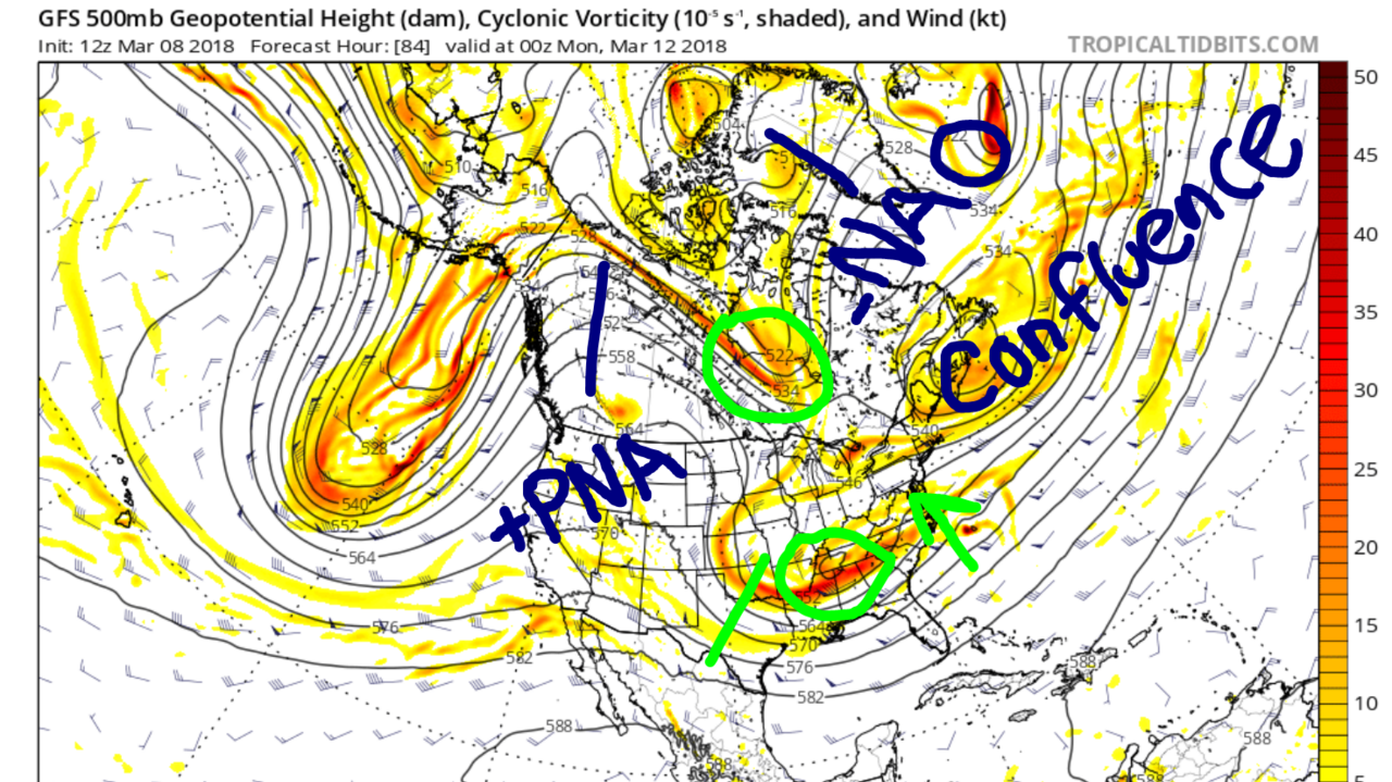
At the time I mentioned the anomalous +PNA ridge, location of the -NAO ridge, and timing of short waves between the northern and southern jet streams as positives which ultimately was the reason why I favored a coastal storm to happen. While areas from NYC and west did not see much from it, most N&W and east of NYC did see accumulating snow. Not Godzilla amounts, but a sizable event nonetheless for March standards.
Here is today's 500mb map from the GFS valid for next week. I want to highlight the differences in the upper air pattern:

*Anomalous +PNA? Not quite.
*-NAO? Yes, but noticeably weaker.
*Confluence? Yes. Almost the same spot.
*Strong vorticity at the base of the trough? Yes.
*Northern stream energy for a potential phase? Maybe.
The first and last points might be the biggest difference. One reason why today's storm made the turn north was because of the late or partial phase with the northern stream energy, made possible by the anomalous western ridge. It does not appear we have that in our favor this go around, but a split-flow could also achieve the same result as long as timing is right.
My preference would be to see our storm come together in the mid-section of the country, which most models show, and slow it down enough to allow a northern vort to phase into the main trough. That would almost guarantee the storm to turn north. My only concern is the flow may be too progressive due to the lack of amplification. I'll take my chances of that with a -NAO and hope future runs slow this down a bit. I was able to say with confidence we would see a coastal storm today. I'm unable to do that for this storm as of now, but it's a full week out. We'll see how this looks in a couple of days from now.
_________________
_______________________________________________________________________________________________________
CLICK HERE to view NJ Strong Snowstorm Classifications
Frank_Wx- Godzilla Seeker
- Posts : 21305
Reputation : 328
Join date : 2013-01-05
Age : 31
Location : Jersey City, NJ -
Re: Long Range Thread 16.0
![]() by rb924119 Tue Mar 13, 2018 7:14 pm
by rb924119 Tue Mar 13, 2018 7:14 pm
rb924119- Meteorologist
- Posts : 6890
Reputation : 194
Join date : 2013-02-06
Age : 32
Location : Greentown, Pa
Re: Long Range Thread 16.0
![]() by Frank_Wx Tue Mar 13, 2018 8:58 pm
by Frank_Wx Tue Mar 13, 2018 8:58 pm
_________________
_______________________________________________________________________________________________________
CLICK HERE to view NJ Strong Snowstorm Classifications
Frank_Wx- Godzilla Seeker
- Posts : 21305
Reputation : 328
Join date : 2013-01-05
Age : 31
Location : Jersey City, NJ -
Page 21 of 34 • 1 ... 12 ... 20, 21, 22 ... 27 ... 34 ![]()
|
|
|