March Observations and Discussions
+23
Dtone
Math23x7
essexcountypete
SoulSingMG
Grselig
Radz
SNOW MAN
mikeypizano
rb924119
RJB8525
amugs
Dunnzoo
Vinnydula
aiannone
sroc4
docstox12
Frank_Wx
weatherwatchermom
billg315
jmanley32
frank 638
dkodgis
CPcantmeasuresnow
27 posters
Page 7 of 7 •  1, 2, 3, 4, 5, 6, 7
 Re: March Observations and Discussions
CPcantmeasuresnow wrote:docstox12 wrote:49 degrees, calm, 30.19 F.Yard still covered with 2 to 3 inches of snowpack 90% and still large snowpiles from plowing.Mist rising from the snow at times,LOL.
Doc:
We may do the whole month of March other than the first day with snow cover and a solid one most of the time at that. May not make it to the first but it will be close.
Flying back now from Florida now it is just a different world down here. Every morning I was checking temps seeing 22, 25, 23 every morning there. It seems like some kind of polar world (The Hoth system?) your viewing when your away from it.
CP, it's the March that pretended to be January! Constant snow cover, cold temperatures.It was a blast to live through and observe! Won't soon forget those 'death bands" over us in that 26 inche snowstorm we had.Aside from February, an epic winter with cold and snow.I would trade a February we had to get a March we have had anytime! Glad you made it back safely!
docstox12- Wx Statistician Guru

- Posts : 8530
Join date : 2013-01-07
 Re: March Observations and Discussions
CPcantmeasuresnow wrote:billg315 wrote:I assume this largely applies to NYC metro area as well. While March is known for the occasional late-season snowstorm, this confirms this year's persistent chill has been significant and anything but ordinary:
http://www.philly.com/philly/news/weather/philadelphia-weather-record-snow-cold-spring-20180328.html
Somewhat of an exaggeration as our March temps will end up 2-3 degrees below normal, nice but nothing earth shattering.
What is impressive is the streak of days in March, 21 at last count in a row, that were below normal, most between 3-7 degrees below so no real out of the ordinary cold but a couple to several degrees bellow each day which has been nice. It has also allowed those of us with a snow pack to keep it almost the entire month.
Yeah this March consistency is the most unsual part. A month known for wild variations was very stable. Stable on the cool side.
Despite that my car is covered in pollen today. Cherry blossoms etc are opening up.
Dtone- Wx Statistician Guru

- Posts : 1738
Join date : 2013-08-26
 Re: March Observations and Discussions
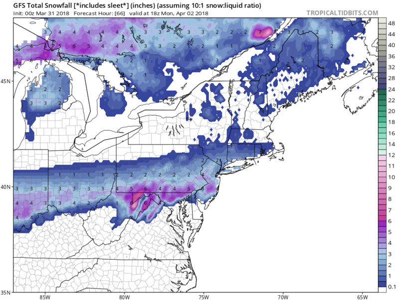
GFS prints out 1 to 3 inches of snow Monday morning.
More snowwwwwww
More snowwwwwww
_________________
_______________________________________________________________________________________________________
CLICK HERE to view NJ Strong Snowstorm Classifications
 Re: March Observations and Discussions
Good news Frank! I need .375 inches to hit 80 for the season.
Mild, cloudy, only 1/2 of snowpack left on the property.
Mild, cloudy, only 1/2 of snowpack left on the property.

docstox12- Wx Statistician Guru

- Posts : 8530
Reputation : 222
Join date : 2013-01-07
Age : 73
Location : Monroe NY
 Re: March Observations and Discussions
My local news 12 forecast just showed the NAM, EURO and GFS. ALL SHOW SNOW MONDAY MORNING. WHAT THE HELLS GOING ON
Guest- Guest
 Re: March Observations and Discussions
Upton:
The biggest change in the forecast is with a frontal wave that
24h hours ago was suppressed to the south of the region as it
moved off the Mid Atlantic coast. There are clear trends in the
operational guidance and their ensembles of a northward shift.
This would bring a light, wet snowfall to the region, late
Sunday night into Monday morning. The event looks to be no
longer than 6-8 hours with a quarter inch or less of liquid
equivalent. The highest amounts would be along the coast with
the potential for 1-2 inches of snowfall. With warm surface
temperatures, impacts are likely to minimal. The upper end of
this storm may be an advisory level event. The flow is just too
progressive to warrant a more significant event. Granted, the
guidance has been deficient the past few winters with the
expansion of precipitation on the northern periphery of these
system due to jet dynamics.
The cold air supply will be provided a cold front that passes
through on Sunday. Highs though will still get into the lower
and mid 50s and then fall off into the 30s Sunday night. This
type of events cool with the onset of the precipitation, which
is likely not until the pre-dawn hours Monday.
_________________
-Alex Iannone-

aiannone- Senior Enthusiast - Mod

- Posts : 4815
Reputation : 92
Join date : 2013-01-07
Location : Saint James, LI (Northwest Suffolk Co.)
 Re: March Observations and Discussions
docstox12 wrote:Good news Frank! I need .375 inches to hit 80 for the season.
Mild, cloudy, only 1/2 of snowpack left on the property.
If you want that 1/2” come on down to Long Island Doc. We are the Snow Caputal of this forum after all
Guest- Guest
 Re: March Observations and Discussions
syosnow94 wrote:My local news 12 forecast just showed the NAM, EURO and GFS. ALL SHOW SNOW MONDAY MORNING. WHAT THE HELLS GOING ON
We all died and are in heaven, that's what's going on.

CPcantmeasuresnow- Wx Statistician Guru

- Posts : 7274
Reputation : 230
Join date : 2013-01-07
Age : 103
Location : Eastern Orange County, NY
 Re: March Observations and Discussions
CPcantmeasuresnow wrote:syosnow94 wrote:My local news 12 forecast just showed the NAM, EURO and GFS. ALL SHOW SNOW MONDAY MORNING. WHAT THE HELLS GOING ON
We all died and are in heaven, that's what's going on.
ha ha...I saw there was a possibility of snow..called my mom and she just screamed on the phone and literally hung up on me...lol(she hates snow and cold).

weatherwatchermom- Senior Enthusiast

- Posts : 3793
Reputation : 78
Join date : 2014-11-25
Location : Hazlet Township, NJ
Sanchize06- Senior Enthusiast

- Posts : 1041
Reputation : 21
Join date : 2013-02-05
Location : Union Beach, NJ
 Re: March Observations and Discussions
I wonder if the Yankees will play on Monday for there game opener
frank 638- Senior Enthusiast

- Posts : 2843
Reputation : 37
Join date : 2016-01-01
Age : 40
Location : bronx ny
 Re: March Observations and Discussions
syosnow94 wrote:docstox12 wrote:Good news Frank! I need .375 inches to hit 80 for the season.
Mild, cloudy, only 1/2 of snowpack left on the property.
If you want that 1/2” come on down to Long Island Doc. We are the Snow Caputal of this forum after all
Monroe HV 79.62 inches.That is all........

docstox12- Wx Statistician Guru

- Posts : 8530
Reputation : 222
Join date : 2013-01-07
Age : 73
Location : Monroe NY
 Re: March Observations and Discussions
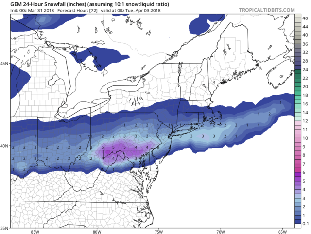
Surprise not much talk in here about this. Impressive for this time of year. This may put my area over the 50 inch mark. Here are some model out put with snow. 2-4 for most.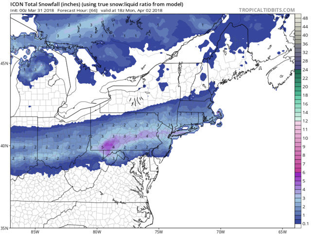
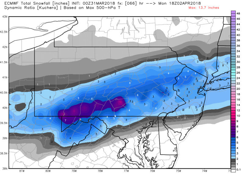


skinsfan1177- Senior Enthusiast

- Posts : 4485
Reputation : 35
Join date : 2013-01-07
Age : 46
Location : Point Pleasant Boro
 Re: March Observations and Discussions
2.7 inches to reach 80, Monday morning might do it.
Then we turn our eyes to April 7th.
Why stop at 80? Let’s keep it rolling right through mid April. Orange Othelia May have been wrong about February but she nailed March and maybe April.
Then we turn our eyes to April 7th.
Why stop at 80? Let’s keep it rolling right through mid April. Orange Othelia May have been wrong about February but she nailed March and maybe April.

CPcantmeasuresnow- Wx Statistician Guru

- Posts : 7274
Reputation : 230
Join date : 2013-01-07
Age : 103
Location : Eastern Orange County, NY
 Re: March Observations and Discussions
Upton discussion, they're starting to get on board now for at least something for everyone except strong UHI areas.
"..In terms of snow intensity, models indicating
modest 850-700 mb level frontogenetic forcing to the south of
LI, placing NE NJ/NYC metro and LI in good dendritic snow growth
zone and potential for a period of moderate snow...
....Based on these factors, a preliminary
estimate of 2 to 4 inches of snow for much of LI and the hills
of NE NJ/Lower Hud looks reasonable, with 1 to 2 inches most
elsewhere. For NYC/NJ metro, urban heat island may keep accums
less than an inch...."
Dtone- Wx Statistician Guru

- Posts : 1738
Reputation : 9
Join date : 2013-08-26
Location : Bronx, NY

dkodgis- Senior Enthusiast

- Posts : 2560
Reputation : 98
Join date : 2013-12-29
 Re: March Observations and Discussions
Timing will be everything with accumulation with this. Right now, starting at 4 or 5 am is big because if it gets heavy it may stick, but remember even overnight temps only get to freezing (in some places not even) right at dawn in most areas Monday. If this delays at all and doesn’t start until 9 or 10 am I think you’ll see a lot of big pretty snowflakes falling but not sticking on most surfaces except maybe the heaviest band wherever that falls (right now probably Trenton NJ to LI).

billg315- Advanced Forecaster - Mod

- Posts : 4483
Reputation : 185
Join date : 2015-01-24
Age : 50
Location : Flemington, NJ
 Re: March Observations and Discussions
_________________
"In weather and in life, there's no winning and losing; there's only winning and learning."
WINTER 2012/2013 TOTALS 43.65"WINTER 2017/2018 TOTALS 62.85" WINTER 2022/2023 TOTALS 4.9"
WINTER 2013/2014 TOTALS 64.85"WINTER 2018/2019 TOTALS 14.25" WINTER 2023/2024 TOTALS 13.1"
WINTER 2014/2015 TOTALS 71.20"WINTER 2019/2020 TOTALS 6.35"
WINTER 2015/2016 TOTALS 35.00"WINTER 2020/2021 TOTALS 37.75"
WINTER 2016/2017 TOTALS 42.25"WINTER 2021/2022 TOTALS 31.65"

sroc4- Admin

- Posts : 8354
Reputation : 302
Join date : 2013-01-07
Location : Wading River, LI
Page 7 of 7 •  1, 2, 3, 4, 5, 6, 7
Permissions in this forum:
You cannot reply to topics in this forum|
|
|

 Home
Home