
 Search
March 7th Godzilla: 1st Call Snow Map
Page 6 of 24 •  1 ... 5, 6, 7 ... 15 ... 24
 ![]()
Re: March 7th Godzilla: 1st Call Snow Map
![]() by MattyICE Tue Mar 06, 2018 4:50 am
by MattyICE Tue Mar 06, 2018 4:50 am
MattyICE- Advanced Forecaster

- Posts : 249
Join date : 2017-11-10
Re: March 7th Godzilla: 1st Call Snow Map
![]() by Taffy Tue Mar 06, 2018 5:12 am
by Taffy Tue Mar 06, 2018 5:12 am
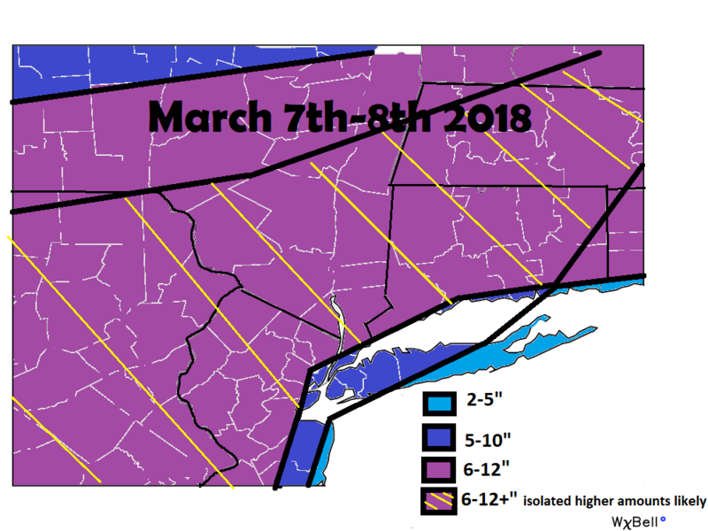
From 10:00pm EST, Tue Mar 6 until 4:00am EST, Thu Mar 8
Action Recommended: Make preparations per the instructions
Issued by: New York City - NY, US, National Weather Service,
...WINTER STORM WARNING IN EFFECT FROM 10 PM THIS EVENING TO 4 AM EST THURSDAY... * WHAT...HEAVY SNOW EXPECTED. TOTAL SNOW ACCUMULATIONS OF 6 TO 12 INCHES, EXCEPT 10 TO 15 INCHES ACROSS INTERIOR PORTIONS OF THE LOWER HUDSON VALLEY, AND MOST OF INTERIOR SOUTHERN CONNECTICUT. LOCALLY HIGHER AMOUNTS ARE POSSIBLE. * WHERE...NEW YORK CITY, NORTHEAST NEW JERSEY, THE LOWER HUDSON VALLEY, SOUTHWESTERN CONNECTICUT, MIDDLESEX, NASSAU AND NORTHWESTERN SUFFOLK COUNTIES. * WHEN...FROM 10 PM THIS EVENING TO 4 AM EST THURSDAY. * ADDITIONAL DETAILS...TRAVEL WILL BE VERY DIFFICULT TO IMPOSSIBLE, INCLUDING DURING THE EVENING COMMUTE ON WEDNESDAY. BE PREPARED FOR SIGNIFICANT REDUCTIONS IN VISIBILITY AT TIMES. PRECAUTIONARY/PREPAREDNESS ACTIONS... A WINTER STORM WARNING FOR SNOW MEANS SEVERE WINTER WEATHER CONDITIONS WILL MAKE TRAVEL VERY HAZARDOUS OR IMPOSSIBLE. IF YOU MUST TRAVEL, KEEP AN EXTRA FLASHLIGHT, FOOD AND WATER IN YOUR VEHICLE IN CASE OF AN EMERGENCY. CHECK LOCAL DEPARTMENT OF TRANSPORTATION INFORMATION SERVICES FOR THE LATEST ROAD CONDITIONS. &&
Taffy- Pro Enthusiast

- Posts : 530
Join date : 2013-10-06
Re: March 7th Godzilla: 1st Call Snow Map
![]() by skinsfan1177 Tue Mar 06, 2018 5:24 am
by skinsfan1177 Tue Mar 06, 2018 5:24 am

skinsfan1177- Senior Enthusiast

- Posts : 4485
Reputation : 35
Join date : 2013-01-07
Age : 46
Location : Point Pleasant Boro
Re: March 7th Godzilla: 1st Call Snow Map
![]() by skinsfan1177 Tue Mar 06, 2018 5:28 am
by skinsfan1177 Tue Mar 06, 2018 5:28 am
skinsfan1177- Senior Enthusiast
- Posts : 4485
Reputation : 35
Join date : 2013-01-07
Age : 46
Location : Point Pleasant Boro
Re: March 7th Godzilla: 1st Call Snow Map
![]() by jmanley32 Tue Mar 06, 2018 5:32 am
by jmanley32 Tue Mar 06, 2018 5:32 am

jmanley32- Senior Enthusiast
- Posts : 20535
Reputation : 108
Join date : 2013-12-12
Age : 43
Location : Yonkers, NY
Re: March 7th Godzilla: 1st Call Snow Map
![]() by jimv45 Tue Mar 06, 2018 5:33 am
by jimv45 Tue Mar 06, 2018 5:33 am
jimv45- Senior Enthusiast
- Posts : 1168
Reputation : 36
Join date : 2013-09-20
Location : Hopewell jct.
Re: March 7th Godzilla: 1st Call Snow Map
![]() by jmanley32 Tue Mar 06, 2018 5:35 am
by jmanley32 Tue Mar 06, 2018 5:35 am
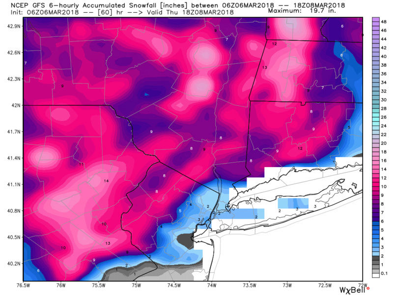
Not happy skins, as CP said Yonkers is about due but looks like this time we may again be the cutoff, WSW could be dropped if the GFS verified. Taht would be a kick to the face. No way am I writing this storm off it IS the 06z run but as I said its a bit disheartening to see the NAM trend west.skinsfan1177 wrote:12z will be telling lets see if euro comes west or not
jmanley32- Senior Enthusiast
- Posts : 20535
Reputation : 108
Join date : 2013-12-12
Age : 43
Location : Yonkers, NY
Re: March 7th Godzilla: 1st Call Snow Map
![]() by jmanley32 Tue Mar 06, 2018 5:36 am
by jmanley32 Tue Mar 06, 2018 5:36 am
Thats it I am moving away from this god forsaken snow hole to fishkill area, me and rb will kick it LOLjimv45 wrote:Rb was saying he thinks more west. Warning now for up to 15 inches for dutchess county.
jmanley32- Senior Enthusiast
- Posts : 20535
Reputation : 108
Join date : 2013-12-12
Age : 43
Location : Yonkers, NY
Re: March 7th Godzilla: 1st Call Snow Map
![]() by jmanley32 Tue Mar 06, 2018 5:38 am
by jmanley32 Tue Mar 06, 2018 5:38 am
jmanley32- Senior Enthusiast
- Posts : 20535
Reputation : 108
Join date : 2013-12-12
Age : 43
Location : Yonkers, NY
Re: March 7th Godzilla: 1st Call Snow Map
![]() by jimv45 Tue Mar 06, 2018 5:40 am
by jimv45 Tue Mar 06, 2018 5:40 am
jimv45- Senior Enthusiast
- Posts : 1168
Reputation : 36
Join date : 2013-09-20
Location : Hopewell jct.
Re: March 7th Godzilla: 1st Call Snow Map
![]() by docstox12 Tue Mar 06, 2018 5:42 am
by docstox12 Tue Mar 06, 2018 5:42 am
jmanley32 wrote:I had to wake to this so so does all the other people in the NYC area, what a aweful thing, even 00z had like 10 inches. now 2.
Wow, a nail biter for sure for areas S and E.I've got elevation, 600 plus feet and more N and W but this westerly trend could even affect up here with mixing issues.Where that rain/snow line sets up early in the storm and it's movement, will tell the tale tomorrow in nowcast.Hoping for an area wide 6 to 12 event so everybody is on the board tomorrow with good news.

docstox12- Wx Statistician Guru

- Posts : 8530
Reputation : 222
Join date : 2013-01-07
Age : 73
Location : Monroe NY
Re: March 7th Godzilla: 1st Call Snow Map
![]() by jmanley32 Tue Mar 06, 2018 5:43 am
by jmanley32 Tue Mar 06, 2018 5:43 am
jmanley32- Senior Enthusiast
- Posts : 20535
Reputation : 108
Join date : 2013-12-12
Age : 43
Location : Yonkers, NY
Re: March 7th Godzilla: 1st Call Snow Map
![]() by jimv45 Tue Mar 06, 2018 5:48 am
by jimv45 Tue Mar 06, 2018 5:48 am
jimv45- Senior Enthusiast
- Posts : 1168
Reputation : 36
Join date : 2013-09-20
Location : Hopewell jct.
Re: March 7th Godzilla: 1st Call Snow Map
![]() by nutleyblizzard Tue Mar 06, 2018 5:57 am
by nutleyblizzard Tue Mar 06, 2018 5:57 am

nutleyblizzard- Senior Enthusiast
- Posts : 1954
Reputation : 41
Join date : 2014-01-30
Age : 58
Location : Nutley, new jersey
Re: March 7th Godzilla: 1st Call Snow Map
![]() by jmanley32 Tue Mar 06, 2018 5:57 am
by jmanley32 Tue Mar 06, 2018 5:57 am
jmanley32- Senior Enthusiast
- Posts : 20535
Reputation : 108
Join date : 2013-12-12
Age : 43
Location : Yonkers, NY
Re: March 7th Godzilla: 1st Call Snow Map
![]() by jmanley32 Tue Mar 06, 2018 5:59 am
by jmanley32 Tue Mar 06, 2018 5:59 am
true but even within 18 hrs or so?nutleyblizzard wrote:Like Bernie says, "windshield wiper with the models". Has anyone noticed with each run it shows a tucked in solution only to kick east the next run. EPS is locked in with the EURO. That's a good model to have this close to the event. GFS is a disaster. It has a lower resolution which makes the temp thermals too warm. I'm discarding it. People need to relax. With the block in place even if the low kisses Cape May County, pattern argues for a ENE track thereafter. That's my feeling anyways. 12z should be a hoot today regardless of the outcome.
jmanley32- Senior Enthusiast
- Posts : 20535
Reputation : 108
Join date : 2013-12-12
Age : 43
Location : Yonkers, NY
Re: March 7th Godzilla: 1st Call Snow Map
![]() by oldtimer Tue Mar 06, 2018 6:03 am
by oldtimer Tue Mar 06, 2018 6:03 am
oldtimer- Senior Enthusiast
- Posts : 1103
Reputation : 14
Join date : 2013-01-16
Age : 78
Location : Port Jefferson Station Suffolk County
Re: March 7th Godzilla: 1st Call Snow Map
![]() by billg315 Tue Mar 06, 2018 6:07 am
by billg315 Tue Mar 06, 2018 6:07 am
rb924119 wrote:billg315 wrote:I was emboldened by Syos to give this a try with limited art skills. Pardon some of the imperfections but you'll get the point.
Green: Mostly rain. Some change to snow possible at very end of storm but little if any accumulation.
Purple: Rain and Snow mixing in the early part of the storm. Will eventually go to all snow, but the early mixing issues will keep totals in check. 3-6"
Blue: Mostly snow. Some rain might mix right on border with pink but this is a solid snow event. 6-10"
Brown (was supposed to be orange :-/ ): All Snow and heavy at times. Jackpot zone. 10-15"
(p.s. It took forever to do this so I did not see Frank's map beforehand. Looks like we are a little different in some spots, but not too far off)
Your basemap looks very familiar.........
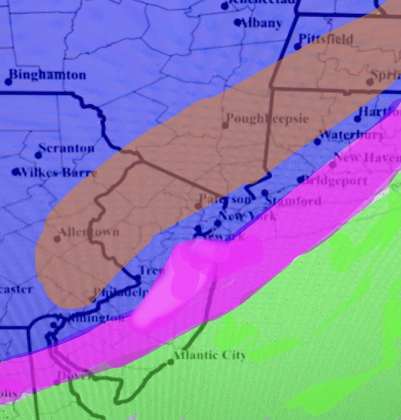
Hahaha. Yes, it should.

billg315- Advanced Forecaster - Mod

- Posts : 4483
Reputation : 185
Join date : 2015-01-24
Age : 50
Location : Flemington, NJ
Re: March 7th Godzilla: 1st Call Snow Map
![]() by docstox12 Tue Mar 06, 2018 6:15 am
by docstox12 Tue Mar 06, 2018 6:15 am
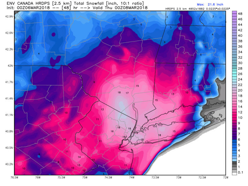
jmanley32 wrote:00z HRDPS, I still say there is a glimmer of hope for NYC area, but curious to see what the next run of this model shows as its in the same camp as the other 00z models
MUUUUUUUCH BETTER!!!! Let's hope this one pans out so we can have a blast tomorrow on the board!!!
docstox12- Wx Statistician Guru
- Posts : 8530
Reputation : 222
Join date : 2013-01-07
Age : 73
Location : Monroe NY
Re: March 7th Godzilla: 1st Call Snow Map
![]() by jmanley32 Tue Mar 06, 2018 6:26 am
by jmanley32 Tue Mar 06, 2018 6:26 am
No not mugs algae lol, sorry two Alsoldtimer wrote:Jman Al said late last night NYC and LI will be toast if it stays tucked in
jmanley32- Senior Enthusiast
- Posts : 20535
Reputation : 108
Join date : 2013-12-12
Age : 43
Location : Yonkers, NY
Re: March 7th Godzilla: 1st Call Snow Map
![]() by Guest Tue Mar 06, 2018 6:49 am
by Guest Tue Mar 06, 2018 6:49 am
The NWS having me for a warning already which they did early this morning while raising amounts gives me some confidence. No Scott and rb thinking west makes me worried
Guest- Guest
Re: March 7th Godzilla: 1st Call Snow Map
![]() by Guest Tue Mar 06, 2018 6:53 am
by Guest Tue Mar 06, 2018 6:53 am

Guest- Guest
Re: March 7th Godzilla: 1st Call Snow Map
![]() by billg315 Tue Mar 06, 2018 6:56 am
by billg315 Tue Mar 06, 2018 6:56 am
Right now I my thought is the Low will hug the coast. I think the NAM is closer on precip but gfs isn’t to be discounted. There will be mixing issues with snow/rain mid storm into NYC and central NJ (almost or maybe to my location) but once the low pulls alongside or just north it will go back to snow for most people. Since snow will be heavy most people who have mixing issues briefly will do just fine. I think LI, at least central LI east is in a bad spot for mixing with rain, but I think you may get a thump of snow at the end late Wed. Evening.
Last edited by billg315 on Tue Mar 06, 2018 6:57 am; edited 1 time in total
billg315- Advanced Forecaster - Mod
- Posts : 4483
Reputation : 185
Join date : 2015-01-24
Age : 50
Location : Flemington, NJ
Re: March 7th Godzilla: 1st Call Snow Map
![]() by CPcantmeasuresnow Tue Mar 06, 2018 6:57 am
by CPcantmeasuresnow Tue Mar 06, 2018 6:57 am

CPcantmeasuresnow- Wx Statistician Guru
- Posts : 7274
Reputation : 230
Join date : 2013-01-07
Age : 103
Location : Eastern Orange County, NY
Re: March 7th Godzilla: 1st Call Snow Map
![]() by sroc4 Tue Mar 06, 2018 7:02 am
by sroc4 Tue Mar 06, 2018 7:02 am
You get what you get and you don't get upset.
Last edited by sroc4 on Tue Mar 06, 2018 7:13 am; edited 2 times in total
_________________
"In weather and in life, there's no winning and losing; there's only winning and learning."
WINTER 2012/2013 TOTALS 43.65"WINTER 2017/2018 TOTALS 62.85" WINTER 2022/2023 TOTALS 4.9"
WINTER 2013/2014 TOTALS 64.85"WINTER 2018/2019 TOTALS 14.25" WINTER 2023/2024 TOTALS 13.1"
WINTER 2014/2015 TOTALS 71.20"WINTER 2019/2020 TOTALS 6.35"
WINTER 2015/2016 TOTALS 35.00"WINTER 2020/2021 TOTALS 37.75"
WINTER 2016/2017 TOTALS 42.25"WINTER 2021/2022 TOTALS 31.65"

sroc4- Admin

- Posts : 8354
Reputation : 302
Join date : 2013-01-07
Location : Wading River, LI
Re: March 7th Godzilla: 1st Call Snow Map
![]() by CPcantmeasuresnow Tue Mar 06, 2018 7:04 am
by CPcantmeasuresnow Tue Mar 06, 2018 7:04 am
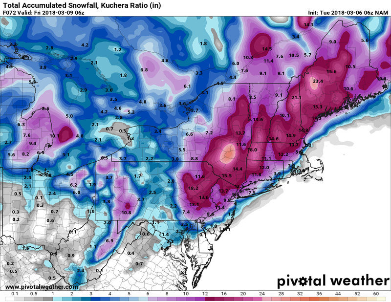
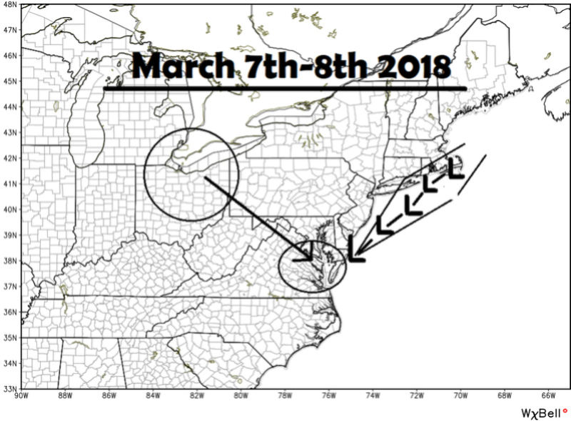
sroc4 wrote:Here is my snow map. I will make a snow maps only thread so we can see everyone's snow maps in one spot. My map is based on a track as indicated. IF the track is shifted slightly N&W within my cone of uncertainty obviously the lines drawn shift accordingly. I still worry that E half of LI esp but the coastal plain in general will not have the best ratios with this storm such that despite heavy snow, accumulations still wont get to where they will just off the coastal plain. A shift to the track slight south and or east will obv bring higher totals into LI and eastern most sections as the soln would be colder. Bottom line it does appear everyone will get something. Start time will begin tonight around Midnight and get cranking as we approach daylight. My map says March 8th as well, but I doubt it lasts into Thursday which I originally thought it would.
You get what you get and you don't get upset.
Thanks Scott, whats the approx begin and end times for this?
CPcantmeasuresnow- Wx Statistician Guru
- Posts : 7274
Reputation : 230
Join date : 2013-01-07
Age : 103
Location : Eastern Orange County, NY
Re: March 7th Godzilla: 1st Call Snow Map
![]() by nutleyblizzard Tue Mar 06, 2018 7:11 am
by nutleyblizzard Tue Mar 06, 2018 7:11 am
nutleyblizzard- Senior Enthusiast
- Posts : 1954
Reputation : 41
Join date : 2014-01-30
Age : 58
Location : Nutley, new jersey
Page 6 of 24 • 1 ... 5, 6, 7 ... 15 ... 24 ![]()