
 Search
Winter's Finale: March 20th-21st Snowstorm
Page 1 of 29 • 1, 2, 3 ... 15 ... 29 ![]()

Winter's Finale: March 20th-21st Snowstorm
![]() by Frank_Wx Fri Mar 16, 2018 10:51 am
by Frank_Wx Fri Mar 16, 2018 10:51 am
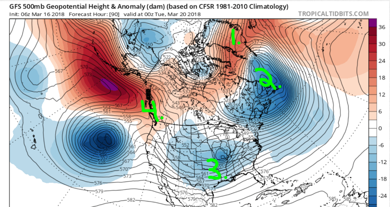
I labeled 4 elements on this 500mb anomaly map valid for Monday night.
1. NAO region
2. 50/50 Low or Confluence region
3. Trough
4. EPO / PNA region
Now take a look at the run to run differences at these 4 locations between the 06z and 00z GFS

The 06z GFS shows a stronger -NAO over Greenland and a more expansive -EPO/+PNA in the western U.S. The confluence area is about the same, more consolidations on the 06z GFS, and the trough is also stronger and more consolidated on the 06z GFS compared to 00z. The biggest takeaway? Models are not done trending with these upper air features. This is the type of system where one small change in the upper atmosphere will create a new solution at the surface on the models.

Let's take a peak at what the upper energy tries to do. The fuchsia circles are key pieces of upper energy critical to the evolution of our storm system. The eastern-most circle is a closed 500mb vort that is responsible for developing a primary low pressure near Oklahoma. This low tracks almost due east, and because of strong temperature and pressure gradients across the north there is a large swath of precipitation that develops in the Midwest that tracks east towards us. Earlier this week we saw some models cut this primary low west near Ohio, but because of the blocking to the north (HP but also a press from the -EPO) models have given up on that solution for the time being. They key is not so much the surface low but the closed 500mb vort. Where does it track and how strong does it get? The 00z GFS showed a weaker 500mb vort so heights along the east coast, coupled with the confluence to the north, remained dampened which kept enough cold air in place for precip to fall in the form of snow. The 06z GFS showed a stronger vort so heights were higher which lead to rising temps and more rain/mix along the coast.
What ends up happening, in my depiction of this whole thing, is the initial 500mb vort breaks apart near the east coast once it "feels" all this blocking in the Atlantic. The 1st half of this system comes from that 500mb vort that broke off the bowling ball upper low in the eastern Pacific. Then we have all these other upper level vorts (the other 3 fuchsia color circles) that are phasing into the trough and creating a brand new 500mb closed low somewhere along the east coast. Where this "2nd" closed low develops will ultimately determine which areas see the greatest amount of snowfall. It is possible some areas see rain/mix from the 1st half of this storm, then depending on where the new 500mb vort forms, see snow the 2nd half. OR some area could stay ALL SNOW for the 1st and 2nd half of this entire event - which is modeled to be greater than 24 hours long.
It is also possible models slow everything down and all these energies consolidate to form just 1 storm. That would eliminate the 2-part storm idea and likely cut down on duration too.
Whatever the case, a very complex storm to forecast and I think someone - as far south as DC to Bawston - could see Godzilla (12"+) or even Roidzilla (24"+) snowfall amounts depending on which scenario comes to fruition. My gut feeling is telling me DC and the Mid-Atlantic is too far south to get into high snow accumulations. I think interior sections, from south-central PA to NEPA, NW NJ, into CT are in a very good spot. The coast, such as Philly to NYC, are on that line. I think these are the cities that could benefit from the "new" closed 500mb vort that develops. These cities could start as rain (from the initial closed 500mb low that raises heights too much) then change to snow later Tuesday or Wednesday. Again, nothing is set in stone but I am just spit balling some realistic scenarios given the time of year.
We'll see what happens.
Happy Tracking - ciao a tutti,
Frank
_________________
_______________________________________________________________________________________________________
CLICK HERE to view NJ Strong Snowstorm Classifications

Frank_Wx- Godzilla Seeker

- Posts : 21305
Reputation : 328
Join date : 2013-01-05
Age : 31
Location : Jersey City, NJ -

Re: Winter's Finale: March 20th-21st Snowstorm
![]() by Frank_Wx Fri Mar 16, 2018 11:03 am
by Frank_Wx Fri Mar 16, 2018 11:03 am


_________________
_______________________________________________________________________________________________________
CLICK HERE to view NJ Strong Snowstorm Classifications
Frank_Wx- Godzilla Seeker
- Posts : 21305
Reputation : 328
Join date : 2013-01-05
Age : 31
Location : Jersey City, NJ -
Tzvi732- Posts : 7
Reputation : 0
Join date : 2015-09-30
Location : lakewood nj
Re: Winter's Finale: March 20th-21st Snowstorm
![]() by skinsfan1177 Fri Mar 16, 2018 11:32 am
by skinsfan1177 Fri Mar 16, 2018 11:32 am
Tzvi732 wrote:Looks warm
Its late March

skinsfan1177- Senior Enthusiast

- Posts : 4485
Reputation : 35
Join date : 2013-01-07
Age : 46
Location : Point Pleasant Boro
Re: Winter's Finale: March 20th-21st Snowstorm
![]() by docstox12 Fri Mar 16, 2018 11:35 am
by docstox12 Fri Mar 16, 2018 11:35 am

docstox12- Wx Statistician Guru

- Posts : 8502
Reputation : 222
Join date : 2013-01-07
Age : 73
Location : Monroe NY
Re: Winter's Finale: March 20th-21st Snowstorm
![]() by amugs Fri Mar 16, 2018 11:53 am
by amugs Fri Mar 16, 2018 11:53 am
For SNJ and the coastal plain possibly but please lets not get into OP runs warm, rain etc. They are just guidance and not the solutions at this point.Tzvi732 wrote:Looks warm
The op models are going to waffle and won't be able to decipher the temps/thermal profiles at this range overall. Climo will be the norm at this range for model depiction as you can see in the deep thunder run.
Frank great write up - lots and as you pointed out lots of possibilities with this set up. The synoptic set up IMO is pointing towards a bowling ball one deep LP that will title Negative in teh Ohio Valley. it has that classic look to it
_________________
Mugs
AKA:King: Snow Weenie
Self Proclaimed
WINTER 2014-15 : 55.12" +.02 for 6 coatings (avg. 35")
WINTER 2015-16 Total - 29.8" (Avg 35")
WINTER 2016-17 : 39.5" so far

amugs- Advanced Forecaster - Mod

- Posts : 15093
Reputation : 213
Join date : 2013-01-07
Age : 54
Location : Hillsdale,NJ
Re: Winter's Finale: March 20th-21st Snowstorm
![]() by jmanley32 Fri Mar 16, 2018 12:04 pm
by jmanley32 Fri Mar 16, 2018 12:04 pm

jmanley32- Senior Enthusiast
- Posts : 20513
Reputation : 108
Join date : 2013-12-12
Age : 42
Location : Yonkers, NY
Re: Winter's Finale: March 20th-21st Snowstorm
![]() by Frank_Wx Fri Mar 16, 2018 12:11 pm
by Frank_Wx Fri Mar 16, 2018 12:11 pm


_________________
_______________________________________________________________________________________________________
CLICK HERE to view NJ Strong Snowstorm Classifications
Frank_Wx- Godzilla Seeker
- Posts : 21305
Reputation : 328
Join date : 2013-01-05
Age : 31
Location : Jersey City, NJ -
Re: Winter's Finale: March 20th-21st Snowstorm
![]() by algae888 Fri Mar 16, 2018 12:12 pm
by algae888 Fri Mar 16, 2018 12:12 pm

algae888- Advanced Forecaster

- Posts : 5311
Reputation : 46
Join date : 2013-02-05
Age : 61
Location : mt. vernon, new york
Re: Winter's Finale: March 20th-21st Snowstorm
![]() by jmanley32 Fri Mar 16, 2018 12:16 pm
by jmanley32 Fri Mar 16, 2018 12:16 pm
jmanley32- Senior Enthusiast
- Posts : 20513
Reputation : 108
Join date : 2013-12-12
Age : 42
Location : Yonkers, NY
Re: Winter's Finale: March 20th-21st Snowstorm
![]() by weatherwatchermom Fri Mar 16, 2018 12:24 pm
by weatherwatchermom Fri Mar 16, 2018 12:24 pm


weatherwatchermom- Senior Enthusiast
- Posts : 3734
Reputation : 77
Join date : 2014-11-25
Age : 60
Location : Hazlet Township, NJ
Re: Winter's Finale: March 20th-21st Snowstorm
![]() by WeatherBob Fri Mar 16, 2018 12:27 pm
by WeatherBob Fri Mar 16, 2018 12:27 pm

WeatherBob- Meteorologist

- Posts : 683
Reputation : 83
Join date : 2013-12-13
Location : Caldwell, NJ - NW Essex County - Altitude 500 FT
Re: Winter's Finale: March 20th-21st Snowstorm
![]() by Guest Fri Mar 16, 2018 12:28 pm
by Guest Fri Mar 16, 2018 12:28 pm
Guest- Guest
Re: Winter's Finale: March 20th-21st Snowstorm
![]() by sroc4 Fri Mar 16, 2018 12:39 pm
by sroc4 Fri Mar 16, 2018 12:39 pm
_________________
"In weather and in life, there's no winning and losing; there's only winning and learning."
WINTER 2012/2013 TOTALS 43.65"WINTER 2017/2018 TOTALS 62.85" WINTER 2022/2023 TOTALS 4.9"
WINTER 2013/2014 TOTALS 64.85"WINTER 2018/2019 TOTALS 14.25" WINTER 2023/2024 TOTALS 13.1"
WINTER 2014/2015 TOTALS 71.20"WINTER 2019/2020 TOTALS 6.35"
WINTER 2015/2016 TOTALS 35.00"WINTER 2020/2021 TOTALS 37.75"
WINTER 2016/2017 TOTALS 42.25"WINTER 2021/2022 TOTALS 31.65"

sroc4- Admin
- Posts : 8331
Reputation : 301
Join date : 2013-01-07
Location : Wading River, LI
Re: Winter's Finale: March 20th-21st Snowstorm
![]() by rb924119 Fri Mar 16, 2018 12:42 pm
by rb924119 Fri Mar 16, 2018 12:42 pm
rb924119- Meteorologist
- Posts : 6889
Reputation : 194
Join date : 2013-02-06
Age : 32
Location : Greentown, Pa
Re: Winter's Finale: March 20th-21st Snowstorm
![]() by Guest Fri Mar 16, 2018 12:58 pm
by Guest Fri Mar 16, 2018 12:58 pm
Last edited by syosnow94 on Fri Mar 16, 2018 12:59 pm; edited 1 time in total
Guest- Guest
Re: Winter's Finale: March 20th-21st Snowstorm
![]() by Grselig Fri Mar 16, 2018 12:58 pm
by Grselig Fri Mar 16, 2018 12:58 pm
rb924119 wrote:Frank, as usual, very well done!!! I'd love to add and comment but I have nothing else to add or comment lol the thoughts and reasoning I set forth about this system several days ago remain unchanged with system, as we are seeing the modeling go toward them (for now). While as happy as I am that is the case, I also feel saddened by the fact that I cannot add anything. So, I have decided to join mugs' team and become a temporary hype-man along with him. As a direct consequence: FIRED. UP.
Thanks for the write-ups!! No matter what happens, I am beginning to appreciate the uniqueness of the storm. Gonna have to reread everything. RB, if you do become the hype man, please make sure you have the appropriate misspellings!!!

Grselig- Senior Enthusiast
- Posts : 1408
Reputation : 140
Join date : 2013-03-04
Age : 54
Location : Wayne NJ
Re: Winter's Finale: March 20th-21st Snowstorm
![]() by sroc4 Fri Mar 16, 2018 1:00 pm
by sroc4 Fri Mar 16, 2018 1:00 pm
Grselig wrote:rb924119 wrote:Frank, as usual, very well done!!! I'd love to add and comment but I have nothing else to add or comment lol the thoughts and reasoning I set forth about this system several days ago remain unchanged with system, as we are seeing the modeling go toward them (for now). While as happy as I am that is the case, I also feel saddened by the fact that I cannot add anything. So, I have decided to join mugs' team and become a temporary hype-man along with him. As a direct consequence: FIRED. UP.
Thanks for the write-ups!! No matter what happens, I am beginning to appreciate the uniqueness of the storm. Gonna have to reread everything. RB, if you do become the hype man, please make sure you have the appropriate misspellings!!!

_________________
"In weather and in life, there's no winning and losing; there's only winning and learning."
WINTER 2012/2013 TOTALS 43.65"WINTER 2017/2018 TOTALS 62.85" WINTER 2022/2023 TOTALS 4.9"
WINTER 2013/2014 TOTALS 64.85"WINTER 2018/2019 TOTALS 14.25" WINTER 2023/2024 TOTALS 13.1"
WINTER 2014/2015 TOTALS 71.20"WINTER 2019/2020 TOTALS 6.35"
WINTER 2015/2016 TOTALS 35.00"WINTER 2020/2021 TOTALS 37.75"
WINTER 2016/2017 TOTALS 42.25"WINTER 2021/2022 TOTALS 31.65"
sroc4- Admin
- Posts : 8331
Reputation : 301
Join date : 2013-01-07
Location : Wading River, LI
Re: Winter's Finale: March 20th-21st Snowstorm
![]() by rb924119 Fri Mar 16, 2018 1:05 pm
by rb924119 Fri Mar 16, 2018 1:05 pm
"THIS really tells the tale as to how close we really are to something historic (*per the GFS Op*). Those d-prog/dT trends are incredible. If you back the flow any more along the East Coast, which I've been of this opinion for a while now, as I think is going to end up occurring, you are really going to just unleash an incredible deformation band on the northern and western sides of mid-level lows. With the highly anomalous p-wat component coupled with the auspicious Synoptics, you are looking at dropping feet of snow over a very large swath of pretty populated real estate, even if it avoids the I-95 itself. Absolutely incredible.
The historic reference was only with respect to the GFS Op; I don't want to mislead anybody. However, the part about seeing the further backing of flow along the East Coast is something I have believed for several days. I think modeling is currently still underestimating some of the height rises ahead of the whole thing, which would increase the southerly and even easterly component (to a degree) and bring the low further north before heading east- northeast. I like the idea of a tighter low closer to the coast. Always have."
Another user in response to my above comments:
"Gefs has the same thing trough deeper and sharper I get we are still all being quite cautious due to lead time still far out but the ceiling is unreal"
rb924119- Meteorologist
- Posts : 6889
Reputation : 194
Join date : 2013-02-06
Age : 32
Location : Greentown, Pa
Re: Winter's Finale: March 20th-21st Snowstorm
![]() by jmanley32 Fri Mar 16, 2018 1:14 pm
by jmanley32 Fri Mar 16, 2018 1:14 pm
amazing Al we the jackpot 18 + don't buy it yet. But it has been colder.algae888 wrote:Today's 12z GFS would make 99% of this forum happy it start snowing 12 p.m. Tuesday still snowing 2 a.m. Thursday
jmanley32- Senior Enthusiast
- Posts : 20513
Reputation : 108
Join date : 2013-12-12
Age : 42
Location : Yonkers, NY
Re: Winter's Finale: March 20th-21st Snowstorm
![]() by dkodgis Fri Mar 16, 2018 1:16 pm
by dkodgis Fri Mar 16, 2018 1:16 pm
Go hard, or go home.

dkodgis- Senior Enthusiast
- Posts : 2493
Reputation : 98
Join date : 2013-12-29
Re: Winter's Finale: March 20th-21st Snowstorm
![]() by rb924119 Fri Mar 16, 2018 1:16 pm
by rb924119 Fri Mar 16, 2018 1:16 pm
rb924119- Meteorologist
- Posts : 6889
Reputation : 194
Join date : 2013-02-06
Age : 32
Location : Greentown, Pa
Re: Winter's Finale: March 20th-21st Snowstorm
![]() by billg315 Fri Mar 16, 2018 1:17 pm
by billg315 Fri Mar 16, 2018 1:17 pm

billg315- Advanced Forecaster - Mod
- Posts : 4462
Reputation : 185
Join date : 2015-01-24
Age : 50
Location : Flemington, NJ
Re: Winter's Finale: March 20th-21st Snowstorm
![]() by amugs Fri Mar 16, 2018 1:17 pm
by amugs Fri Mar 16, 2018 1:17 pm

_________________
Mugs
AKA:King: Snow Weenie
Self Proclaimed
WINTER 2014-15 : 55.12" +.02 for 6 coatings (avg. 35")
WINTER 2015-16 Total - 29.8" (Avg 35")
WINTER 2016-17 : 39.5" so far
amugs- Advanced Forecaster - Mod
- Posts : 15093
Reputation : 213
Join date : 2013-01-07
Age : 54
Location : Hillsdale,NJ
Re: Winter's Finale: March 20th-21st Snowstorm
![]() by billg315 Fri Mar 16, 2018 1:18 pm
by billg315 Fri Mar 16, 2018 1:18 pm
amugs wrote:JESUS H LOOK AT THIS GEFS!!!!!!!!
It’s digging. :-)
billg315- Advanced Forecaster - Mod
- Posts : 4462
Reputation : 185
Join date : 2015-01-24
Age : 50
Location : Flemington, NJ
Page 1 of 29 • 1, 2, 3 ... 15 ... 29 ![]()
|
|
|