
 Search
Long Range Thread 18.0
Page 30 of 36 •  1 ... 16 ... 29, 30, 31 ... 36
 ![]()
Re: Long Range Thread 18.0
![]() by maxwell12103 Mon Feb 25, 2019 3:44 pm
by maxwell12103 Mon Feb 25, 2019 3:44 pm
maxwell12103- Posts : 7
Join date : 2019-02-24
Re: Long Range Thread 18.0
![]() by algae888 Mon Feb 25, 2019 5:15 pm
by algae888 Mon Feb 25, 2019 5:15 pm
algae888- Advanced Forecaster

- Posts : 5311
Join date : 2013-02-05
Re: Long Range Thread 18.0
![]() by mwilli Mon Feb 25, 2019 7:10 pm
by mwilli Mon Feb 25, 2019 7:10 pm
mwilli- Posts : 132
Reputation : 3
Join date : 2019-02-11
Re: Long Range Thread 18.0
![]() by amugs Mon Feb 25, 2019 7:38 pm
by amugs Mon Feb 25, 2019 7:38 pm
AND WOW JMAN!!
MWObservatory
@MWObs
Follow Follow @MWObs
More
Current peak wind is 171mph! Surpassing the previous February wind record (166 MPH set in 1972). #NHwx #wind #mountain
4:10 PM - 25 Feb 2019
Good solid call - Thursday Clipper
_________________
Mugs
AKA:King: Snow Weenie
Self Proclaimed
WINTER 2014-15 : 55.12" +.02 for 6 coatings (avg. 35")
WINTER 2015-16 Total - 29.8" (Avg 35")
WINTER 2016-17 : 39.5" so far

amugs- Advanced Forecaster - Mod

- Posts : 15093
Reputation : 213
Join date : 2013-01-07
Age : 54
Location : Hillsdale,NJ
Re: Long Range Thread 18.0
![]() by sroc4 Mon Feb 25, 2019 8:23 pm
by sroc4 Mon Feb 25, 2019 8:23 pm
amugs wrote:WOW does March look cold like a lion!!
AND WOW JMAN!!
MWObservatory
@MWObs
Follow Follow @MWObs
More
Current peak wind is 171mph! Surpassing the previous February wind record (166 MPH set in 1972). #NHwx #wind #mountain
4:10 PM - 25 Feb 2019
Good solid call - Thursday Clipper
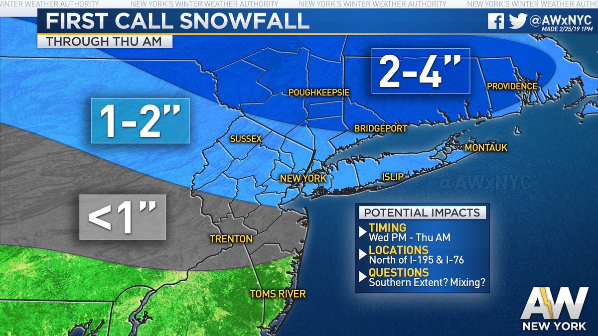
Going to likely need to extend the 2-4" line south from that map.

_________________
"In weather and in life, there's no winning and losing; there's only winning and learning."
WINTER 2012/2013 TOTALS 43.65"WINTER 2017/2018 TOTALS 62.85" WINTER 2022/2023 TOTALS 4.9"
WINTER 2013/2014 TOTALS 64.85"WINTER 2018/2019 TOTALS 14.25" WINTER 2023/2024 TOTALS 13.1"
WINTER 2014/2015 TOTALS 71.20"WINTER 2019/2020 TOTALS 6.35"
WINTER 2015/2016 TOTALS 35.00"WINTER 2020/2021 TOTALS 37.75"
WINTER 2016/2017 TOTALS 42.25"WINTER 2021/2022 TOTALS 31.65"

sroc4- Admin

- Posts : 8331
Reputation : 301
Join date : 2013-01-07
Location : Wading River, LI
Re: Long Range Thread 18.0
![]() by sroc4 Tue Feb 26, 2019 5:53 am
by sroc4 Tue Feb 26, 2019 5:53 am
sroc4 wrote:amugs wrote:WOW does March look cold like a lion!!
AND WOW JMAN!!
MWObservatory
@MWObs
Follow Follow @MWObs
More
Current peak wind is 171mph! Surpassing the previous February wind record (166 MPH set in 1972). #NHwx #wind #mountain
4:10 PM - 25 Feb 2019
Good solid call - Thursday Clipper
Going to likely need to extend the 2-4" line south from that map.
And just like that models trended opposite of the map I drew.
_________________
"In weather and in life, there's no winning and losing; there's only winning and learning."
WINTER 2012/2013 TOTALS 43.65"WINTER 2017/2018 TOTALS 62.85" WINTER 2022/2023 TOTALS 4.9"
WINTER 2013/2014 TOTALS 64.85"WINTER 2018/2019 TOTALS 14.25" WINTER 2023/2024 TOTALS 13.1"
WINTER 2014/2015 TOTALS 71.20"WINTER 2019/2020 TOTALS 6.35"
WINTER 2015/2016 TOTALS 35.00"WINTER 2020/2021 TOTALS 37.75"
WINTER 2016/2017 TOTALS 42.25"WINTER 2021/2022 TOTALS 31.65"
sroc4- Admin
- Posts : 8331
Reputation : 301
Join date : 2013-01-07
Location : Wading River, LI
Re: Long Range Thread 18.0
![]() by heehaw453 Tue Feb 26, 2019 6:19 am
by heehaw453 Tue Feb 26, 2019 6:19 am
Cold seems to be more certain though.
heehaw453- Advanced Forecaster
- Posts : 3906
Reputation : 86
Join date : 2014-01-20
Location : Bedminster Township, PA Elevation 600' ASL
Re: Long Range Thread 18.0
![]() by dkodgis Tue Feb 26, 2019 1:16 pm
by dkodgis Tue Feb 26, 2019 1:16 pm

dkodgis- Senior Enthusiast

- Posts : 2501
Reputation : 98
Join date : 2013-12-29
Re: Long Range Thread 18.0
![]() by crippo84 Tue Feb 26, 2019 1:42 pm
by crippo84 Tue Feb 26, 2019 1:42 pm

crippo84- Posts : 383
Reputation : 20
Join date : 2013-11-07
Age : 40
Location : East Village, NYC
Re: Long Range Thread 18.0
![]() by sroc4 Tue Feb 26, 2019 1:59 pm
by sroc4 Tue Feb 26, 2019 1:59 pm
crippo84 wrote:One day we hear March will warm up after the first week. The next we hear it's expected to be cold. As this winter has shown, the long range can't really be trusted. Probably best not to speculate too much at this point.
With the MJO doing what its doing expect the next 10-14 days to avg below normal. Confidence level = moderate to high with that statement
And early next week the potential for a significant snowfall exists
_________________
"In weather and in life, there's no winning and losing; there's only winning and learning."
WINTER 2012/2013 TOTALS 43.65"WINTER 2017/2018 TOTALS 62.85" WINTER 2022/2023 TOTALS 4.9"
WINTER 2013/2014 TOTALS 64.85"WINTER 2018/2019 TOTALS 14.25" WINTER 2023/2024 TOTALS 13.1"
WINTER 2014/2015 TOTALS 71.20"WINTER 2019/2020 TOTALS 6.35"
WINTER 2015/2016 TOTALS 35.00"WINTER 2020/2021 TOTALS 37.75"
WINTER 2016/2017 TOTALS 42.25"WINTER 2021/2022 TOTALS 31.65"
sroc4- Admin
- Posts : 8331
Reputation : 301
Join date : 2013-01-07
Location : Wading River, LI
Re: Long Range Thread 18.0
![]() by crippo84 Tue Feb 26, 2019 2:18 pm
by crippo84 Tue Feb 26, 2019 2:18 pm
sroc4 wrote:crippo84 wrote:One day we hear March will warm up after the first week. The next we hear it's expected to be cold. As this winter has shown, the long range can't really be trusted. Probably best not to speculate too much at this point.
With the MJO doing what its doing expect the next 10-14 days to avg below normal. Confidence level = moderate to high with that statement
And early next week the potential for a significant snowfall exists
Thanks Scott. Always appreciate and trust your guidance. I know many have given up and thrown in the towel, but I can't get over going through winter without one significant snow chance to track. Hoping for the best next week.
crippo84- Posts : 383
Reputation : 20
Join date : 2013-11-07
Age : 40
Location : East Village, NYC
Re: Long Range Thread 18.0
![]() by sroc4 Tue Feb 26, 2019 2:39 pm
by sroc4 Tue Feb 26, 2019 2:39 pm
crippo84 wrote:sroc4 wrote:crippo84 wrote:One day we hear March will warm up after the first week. The next we hear it's expected to be cold. As this winter has shown, the long range can't really be trusted. Probably best not to speculate too much at this point.
With the MJO doing what its doing expect the next 10-14 days to avg below normal. Confidence level = moderate to high with that statement
And early next week the potential for a significant snowfall exists
Thanks Scott. Always appreciate and trust your guidance. I know many have given up and thrown in the towel, but I can't get over going through winter without one significant snow chance to track. Hoping for the best next week.
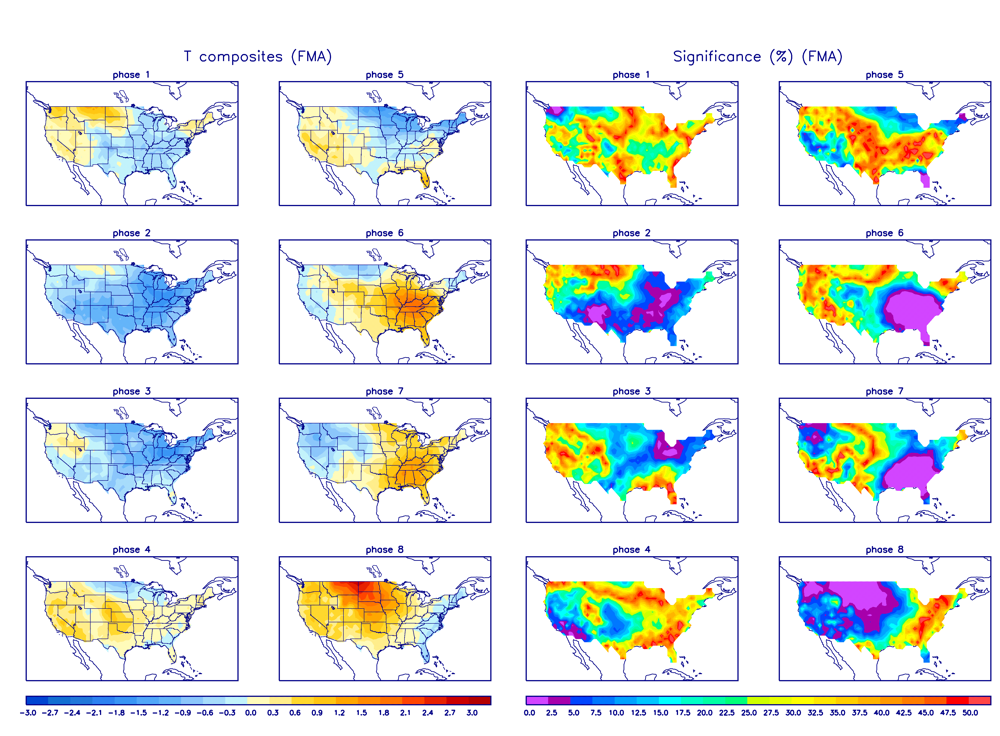
You bet and thanks. I myself have thrown in the towel a long time ago, but that doesnt mean we still cant get something to come through. Regardless of how the past has gone one always has to remain objective about the present and future. MJO rounding through cold phases for this time of year(see below). Both GEFS and EURO ens are for the first time in a long time in agreement regarding this. SOI is cooperating.
Side note. I really have not done much in depth analysis of the overall pattern so while I am pretty confident in the BN temps coming up Im not nearly as confident yet about the significant snow threats. That said the look to the pattern on the GFS and Euro ensemble mean makes me think that the blocking into Alaska, but also into NW Canada will force the TPV far enough into SE Canada to prevent anything coming out of the south from cutting. There also seems to be just enough higher heights in the N Atlantic to potentially allow the N and southern streams to phase leading to an actual Nor Eatser type set up here for early next week with this look. I "like" the look, but dont love the look. As per usual timing is everything. Fingers crossed, ice cubes in toilet.


_________________
"In weather and in life, there's no winning and losing; there's only winning and learning."
WINTER 2012/2013 TOTALS 43.65"WINTER 2017/2018 TOTALS 62.85" WINTER 2022/2023 TOTALS 4.9"
WINTER 2013/2014 TOTALS 64.85"WINTER 2018/2019 TOTALS 14.25" WINTER 2023/2024 TOTALS 13.1"
WINTER 2014/2015 TOTALS 71.20"WINTER 2019/2020 TOTALS 6.35"
WINTER 2015/2016 TOTALS 35.00"WINTER 2020/2021 TOTALS 37.75"
WINTER 2016/2017 TOTALS 42.25"WINTER 2021/2022 TOTALS 31.65"
sroc4- Admin
- Posts : 8331
Reputation : 301
Join date : 2013-01-07
Location : Wading River, LI
Re: Long Range Thread 18.0
![]() by heehaw453 Tue Feb 26, 2019 3:14 pm
by heehaw453 Tue Feb 26, 2019 3:14 pm
sroc4 wrote:crippo84 wrote:sroc4 wrote:crippo84 wrote:One day we hear March will warm up after the first week. The next we hear it's expected to be cold. As this winter has shown, the long range can't really be trusted. Probably best not to speculate too much at this point.
With the MJO doing what its doing expect the next 10-14 days to avg below normal. Confidence level = moderate to high with that statement
And early next week the potential for a significant snowfall exists
Thanks Scott. Always appreciate and trust your guidance. I know many have given up and thrown in the towel, but I can't get over going through winter without one significant snow chance to track. Hoping for the best next week.
You bet and thanks. I myself have thrown in the towel a long time ago, but that doesnt mean we still cant get something to come through. Regardless of how the past has gone one always has to remain objective about the present and future. MJO rounding through cold phases for this time of year(see below). Both GEFS and EURO ens are for the first time in a long time in agreement regarding this. SOI is cooperating.
Side note. I really have not done much in depth analysis of the overall pattern so while I am pretty confident in the BN temps coming up Im not nearly as confident yet about the significant snow threats. That said the look to the pattern on the GFS and Euro ensemble mean makes me think that the blocking into Alaska, but also into NW Canada will force the TPV far enough into SE Canada to prevent anything coming out of the south from cutting. There also seems to be just enough higher heights in the N Atlantic to potentially allow the N and southern streams to phase leading to an actual Nor Eatser type set up here for early next week with this look. I "like" the look, but dont love the look. As per usual timing is everything. Fingers crossed, ice cubes in toilet.
Nice write up! Somewhat of a progressive flow, so there is somewhat of a limit to what we'll get regardless of how this plays out. There are a lot of pieces of energy over the next several days, so I expect some swings and think this is a 72 hour lead time kind of deal before we have a better grasp on the threat. So in short trust nothing just yet, but do believe this has a ceiling.
heehaw453- Advanced Forecaster
- Posts : 3906
Reputation : 86
Join date : 2014-01-20
Location : Bedminster Township, PA Elevation 600' ASL
Re: Long Range Thread 18.0
![]() by hyde345 Tue Feb 26, 2019 4:11 pm
by hyde345 Tue Feb 26, 2019 4:11 pm

hyde345- Pro Enthusiast

- Posts : 1082
Reputation : 48
Join date : 2013-01-08
Location : Hyde Park, NY
Re: Long Range Thread 18.0
![]() by jmanley32 Tue Feb 26, 2019 4:25 pm
by jmanley32 Tue Feb 26, 2019 4:25 pm

jmanley32- Senior Enthusiast
- Posts : 20516
Reputation : 108
Join date : 2013-12-12
Age : 42
Location : Yonkers, NY
Re: Long Range Thread 18.0
![]() by amugs Tue Feb 26, 2019 5:39 pm
by amugs Tue Feb 26, 2019 5:39 pm
The models will not have things sorts out possibly 12 or 18 hours before the storm is to hit. Ju st my opinion here. Do we have chances yes, a godzI'll not seeing it at the time but as he eh haw said we have a ceiling limit to our snowstorms unless we get solid blocking on the Atlantic side.
Cold is here till.about mid.month. let's hope we can get some good moisture to dance with it.
_________________
Mugs
AKA:King: Snow Weenie
Self Proclaimed
WINTER 2014-15 : 55.12" +.02 for 6 coatings (avg. 35")
WINTER 2015-16 Total - 29.8" (Avg 35")
WINTER 2016-17 : 39.5" so far
amugs- Advanced Forecaster - Mod
- Posts : 15093
Reputation : 213
Join date : 2013-01-07
Age : 54
Location : Hillsdale,NJ
Re: Long Range Thread 18.0
![]() by skinsfan1177 Tue Feb 26, 2019 5:44 pm
by skinsfan1177 Tue Feb 26, 2019 5:44 pm

skinsfan1177- Senior Enthusiast
- Posts : 4485
Reputation : 35
Join date : 2013-01-07
Age : 46
Location : Point Pleasant Boro
Re: Long Range Thread 18.0
![]() by heehaw453 Wed Feb 27, 2019 9:29 am
by heehaw453 Wed Feb 27, 2019 9:29 am
heehaw453- Advanced Forecaster
- Posts : 3906
Reputation : 86
Join date : 2014-01-20
Location : Bedminster Township, PA Elevation 600' ASL
Re: Long Range Thread 18.0
![]() by heehaw453 Wed Feb 27, 2019 10:43 am
by heehaw453 Wed Feb 27, 2019 10:43 am

heehaw453- Advanced Forecaster
- Posts : 3906
Reputation : 86
Join date : 2014-01-20
Location : Bedminster Township, PA Elevation 600' ASL
Re: Long Range Thread 18.0
![]() by heehaw453 Wed Feb 27, 2019 11:16 am
by heehaw453 Wed Feb 27, 2019 11:16 am

heehaw453- Advanced Forecaster
- Posts : 3906
Reputation : 86
Join date : 2014-01-20
Location : Bedminster Township, PA Elevation 600' ASL
Re: Long Range Thread 18.0
![]() by rb924119 Wed Feb 27, 2019 11:50 am
by rb924119 Wed Feb 27, 2019 11:50 am
I agree with @earthlight here; the -EPO is not the be-all end-all for snow storms along the East Coast. Sure, it helps, but you need other factors to work constructively as well, and in this case, we do not that enough of that for things to work out on a large scale for our area (in my opinion). I haven’t been enthused with any of these threats for quite some time, and remain unenthused for the time being.
rb924119- Meteorologist

- Posts : 6890
Reputation : 194
Join date : 2013-02-06
Age : 32
Location : Greentown, Pa
Re: Long Range Thread 18.0
![]() by heehaw453 Wed Feb 27, 2019 11:59 am
by heehaw453 Wed Feb 27, 2019 11:59 am
rb924119 wrote:
I agree with @earthlight here; the -EPO is not the be-all end-all for snow storms along the East Coast. Sure, it helps, but you need other factors to work constructively as well, and in this case, we do not that enough of that for things to work out on a large scale for our area (in my opinion). I haven’t been enthused with any of these threats for quite some time, and remain unenthused for the time being.
rb do you mean you are concerned about track and warm air? Or something else?
heehaw453- Advanced Forecaster
- Posts : 3906
Reputation : 86
Join date : 2014-01-20
Location : Bedminster Township, PA Elevation 600' ASL
Re: Long Range Thread 18.0
![]() by sroc4 Wed Feb 27, 2019 12:58 pm
by sroc4 Wed Feb 27, 2019 12:58 pm
rb924119 wrote:
I agree with @earthlight here; the -EPO is not the be-all end-all for snow storms along the East Coast. Sure, it helps, but you need other factors to work constructively as well, and in this case, we do not that enough of that for things to work out on a large scale for our area (in my opinion). I haven’t been enthused with any of these threats for quite some time, and remain unenthused for the time being.
I am actually going to respectfully disgree with you and Earthlight JH on this one. Forget "-EPO" and look at the evolution and progression of the ridging in the Alaska/NW Canada region for late Sat through late Sunday into Monday. I def believe there is probably the best potential all winter for cyclogenesis along the coast.
Im not talking about a crawler that can dump 12-24", but a 6-12"+ event is possible. Dont ask about in your back yard yet folks as exact track makes all the difference here. Hopefully I will have maps labeled etc later hopefully to show more of my thinking here. It will come down to timing of two key pieces of energy. 1 involving a spoke on the TPV wheel(steering energy), and 2 the other being the Pac energy entering the West coast of California on Saturday(our system). Also there is a rule, and its not a hardened fast rule, but a rule that states where the energy enters the west coast look for the energy to exit the EC on a similar Latitude.
_________________
"In weather and in life, there's no winning and losing; there's only winning and learning."
WINTER 2012/2013 TOTALS 43.65"WINTER 2017/2018 TOTALS 62.85" WINTER 2022/2023 TOTALS 4.9"
WINTER 2013/2014 TOTALS 64.85"WINTER 2018/2019 TOTALS 14.25" WINTER 2023/2024 TOTALS 13.1"
WINTER 2014/2015 TOTALS 71.20"WINTER 2019/2020 TOTALS 6.35"
WINTER 2015/2016 TOTALS 35.00"WINTER 2020/2021 TOTALS 37.75"
WINTER 2016/2017 TOTALS 42.25"WINTER 2021/2022 TOTALS 31.65"
sroc4- Admin
- Posts : 8331
Reputation : 301
Join date : 2013-01-07
Location : Wading River, LI
Re: Long Range Thread 18.0
![]() by heehaw453 Wed Feb 27, 2019 1:26 pm
by heehaw453 Wed Feb 27, 2019 1:26 pm
sroc4 wrote:rb924119 wrote:
I agree with @earthlight here; the -EPO is not the be-all end-all for snow storms along the East Coast. Sure, it helps, but you need other factors to work constructively as well, and in this case, we do not that enough of that for things to work out on a large scale for our area (in my opinion). I haven’t been enthused with any of these threats for quite some time, and remain unenthused for the time being.
I am actually going to respectfully disgree with you and Earthlight JH on this one. Forget "-EPO" and look at the evolution and progression of the ridging in the Alaska/NW Canada region for late Sat through late Sunday into Monday. I def believe there is probably the best potential all winter for cyclogenesis along the coast.
Im not talking about a crawler that can dump 12-24", but a 6-12"+ event is possible. Dont ask about in your back yard yet folks as exact track makes all the difference here. Hopefully I will have maps labeled etc later hopefully to show more of my thinking here. It will come down to timing of two key pieces of energy. 1 involving a spoke on the TPV wheel(steering energy), and 2 the other being the Pac energy entering the West coast of California on Saturday(our system). Also there is a rule, and its not a hardened fast rule, but a rule that states where the energy enters the west coast look for the energy to exit the EC on a similar Latitude.
I agree and do think there is a coastal that will occur. Track will determine whether it's another disappointment or not. Guidance yesterday had suppressed solutions and today they are BM and inside BM. My guess is this will vacillate for another 2 days before we can nail that track down. But at 100+ hours out 150 mile swings are still quite possible.
heehaw453- Advanced Forecaster
- Posts : 3906
Reputation : 86
Join date : 2014-01-20
Location : Bedminster Township, PA Elevation 600' ASL
Re: Long Range Thread 18.0
![]() by SENJsnowman Wed Feb 27, 2019 2:40 pm
by SENJsnowman Wed Feb 27, 2019 2:40 pm
heehaw453 wrote:The NAM is still trying to sell 1-3" of snow on Friday especially from 195 points south. I would have thought it'd given that up by now. There is just not much support for it.
Actually a few models like that possibility. I'm in no way advocating for any of them, but for the sake of convo:
NAM keeps the lp center like 200 miles SE of NJ, but drops 1-3" of all snow with an expansive NE precip shield.
The CMC brings the LP up the coast, with a 1-3" front end of thump to most of the forum, before changing to all rain.
And the NAVGEM indicated several hours of snow for southern NJ more in line with the NAM, a glancing blow on the northern edge of a system.
A system that all 3 of these models have bringing an easy 6"+ of white gold to Maryland and Northern Virginia...again! lol!
GFS gives it no shot from the start.
SENJsnowman- Senior Enthusiast
- Posts : 1186
Reputation : 61
Join date : 2017-01-06
Age : 51
Location : Bayville, NJ
Re: Long Range Thread 18.0
![]() by heehaw453 Wed Feb 27, 2019 2:50 pm
by heehaw453 Wed Feb 27, 2019 2:50 pm
SENJsnowman wrote:heehaw453 wrote:The NAM is still trying to sell 1-3" of snow on Friday especially from 195 points south. I would have thought it'd given that up by now. There is just not much support for it.
Actually a few models like that possibility. I'm in no way advocating for any of them, but for the sake of convo:
NAM keeps the lp center like 200 miles SE of NJ, but drops 1-3" of all snow with an expansive NE precip shield.
The CMC brings the LP up the coast, with a 1-3" front end of thump to most of the forum, before changing to all rain.
And the NAVGEM indicated several hours of snow for southern NJ more in line with the NAM, a glancing blow on the northern edge of a system.
A system that all 3 of these models have bringing an easy 6"+ of white gold to Maryland and Northern Virginia...again! lol!
GFS gives it no shot from the start.
I think the latest SREF is now inline with 12Z NAM. It definitely has been ticking north on most guidance today.
heehaw453- Advanced Forecaster
- Posts : 3906
Reputation : 86
Join date : 2014-01-20
Location : Bedminster Township, PA Elevation 600' ASL
Re: Long Range Thread 18.0
![]() by SENJsnowman Wed Feb 27, 2019 3:07 pm
by SENJsnowman Wed Feb 27, 2019 3:07 pm
See what happens...
SENJsnowman- Senior Enthusiast
- Posts : 1186
Reputation : 61
Join date : 2017-01-06
Age : 51
Location : Bayville, NJ
Page 30 of 36 • 1 ... 16 ... 29, 30, 31 ... 36 ![]()