
 Search
Thurs/Fri 1/17 -18 Clipper System
Page 2 of 3 •  1, 2, 3
 ![]()
Re: Thurs/Fri 1/17 -18 Clipper System
![]() by billg315 Tue Jan 15, 2019 9:51 am
by billg315 Tue Jan 15, 2019 9:51 am
billg315- Advanced Forecaster - Mod

- Posts : 4466
Join date : 2015-01-24
Re: Thurs/Fri 1/17 -18 Clipper System
![]() by Guest Tue Jan 15, 2019 10:06 am
by Guest Tue Jan 15, 2019 10:06 am
Frank_Wx wrote:amugs wrote:6Z Euro compliments of AllSnow 33&rain
Colder
It will be a decent event for those N&W of NYC. For the city itself and the coastal plain not so much.
But at least it is something.

I’ve been logged off but following due to my INSANE ANGER AND FRUSTRATION AT THIS WINTER. This threat and Franks comment just cements my decision. This is a joke and trending weakened which screws us for the weekend. But it’s coming.....
Guest- Guest
Re: Thurs/Fri 1/17 -18 Clipper System
![]() by Frank_Wx Tue Jan 15, 2019 10:29 am
by Frank_Wx Tue Jan 15, 2019 10:29 am

_________________
_______________________________________________________________________________________________________
CLICK HERE to view NJ Strong Snowstorm Classifications

Frank_Wx- Godzilla Seeker

- Posts : 21305
Reputation : 328
Join date : 2013-01-05
Age : 31
Location : Jersey City, NJ -

Re: Thurs/Fri 1/17 -18 Clipper System
![]() by aiannone Tue Jan 15, 2019 3:38 pm
by aiannone Tue Jan 15, 2019 3:38 pm
_________________
-Alex Iannone-

aiannone- Senior Enthusiast - Mod
- Posts : 4813
Reputation : 92
Join date : 2013-01-07
Location : Saint James, LI (Northwest Suffolk Co.)
Re: Thurs/Fri 1/17 -18 Clipper System
![]() by Frank_Wx Tue Jan 15, 2019 3:44 pm
by Frank_Wx Tue Jan 15, 2019 3:44 pm
aiannone wrote:18z NAM very weak for the thursday night-fri storm. Bodes well for the weekend i believe
It does not
But it's ok - the changes happening in the Pacific are more important than any trends that happen with this Clipper.
_________________
_______________________________________________________________________________________________________
CLICK HERE to view NJ Strong Snowstorm Classifications
Frank_Wx- Godzilla Seeker
- Posts : 21305
Reputation : 328
Join date : 2013-01-05
Age : 31
Location : Jersey City, NJ -
Re: Thurs/Fri 1/17 -18 Clipper System
![]() by aiannone Tue Jan 15, 2019 3:45 pm
by aiannone Tue Jan 15, 2019 3:45 pm
Frank_Wx wrote:aiannone wrote:18z NAM very weak for the thursday night-fri storm. Bodes well for the weekend i believe
It does not
But it's ok - the changes happening in the Pacific are more important than any trends that happen with this Clipper.
Ohh, so we want a stronger system?
_________________
-Alex Iannone-
aiannone- Senior Enthusiast - Mod
- Posts : 4813
Reputation : 92
Join date : 2013-01-07
Location : Saint James, LI (Northwest Suffolk Co.)
Re: Thurs/Fri 1/17 -18 Clipper System
![]() by aiannone Tue Jan 15, 2019 3:46 pm
by aiannone Tue Jan 15, 2019 3:46 pm
_________________
-Alex Iannone-
aiannone- Senior Enthusiast - Mod
- Posts : 4813
Reputation : 92
Join date : 2013-01-07
Location : Saint James, LI (Northwest Suffolk Co.)
Re: Thurs/Fri 1/17 -18 Clipper System
![]() by Guest Tue Jan 15, 2019 3:49 pm
by Guest Tue Jan 15, 2019 3:49 pm
aiannone wrote:Frank_Wx wrote:aiannone wrote:18z NAM very weak for the thursday night-fri storm. Bodes well for the weekend i believe
It does not
But it's ok - the changes happening in the Pacific are more important than any trends that happen with this Clipper.
Ohh, so we want a stronger system?
Stronger system drags the baroclinic zone further south. That’s what we want
Guest- Guest
Re: Thurs/Fri 1/17 -18 Clipper System
![]() by aiannone Tue Jan 15, 2019 3:53 pm
by aiannone Tue Jan 15, 2019 3:53 pm
syosnow94 wrote:aiannone wrote:Frank_Wx wrote:aiannone wrote:18z NAM very weak for the thursday night-fri storm. Bodes well for the weekend i believe
It does not
But it's ok - the changes happening in the Pacific are more important than any trends that happen with this Clipper.
Ohh, so we want a stronger system?
Stronger system drags the baroclinic zone further south. That’s what we want
Makes sense! thanks for the explanation
_________________
-Alex Iannone-
aiannone- Senior Enthusiast - Mod
- Posts : 4813
Reputation : 92
Join date : 2013-01-07
Location : Saint James, LI (Northwest Suffolk Co.)
Re: Thurs/Fri 1/17 -18 Clipper System
![]() by aiannone Tue Jan 15, 2019 9:00 pm
by aiannone Tue Jan 15, 2019 9:00 pm
_________________
-Alex Iannone-
aiannone- Senior Enthusiast - Mod
- Posts : 4813
Reputation : 92
Join date : 2013-01-07
Location : Saint James, LI (Northwest Suffolk Co.)
Re: Thurs/Fri 1/17 -18 Clipper System
![]() by aiannone Tue Jan 15, 2019 9:23 pm
by aiannone Tue Jan 15, 2019 9:23 pm
_________________
-Alex Iannone-
aiannone- Senior Enthusiast - Mod
- Posts : 4813
Reputation : 92
Join date : 2013-01-07
Location : Saint James, LI (Northwest Suffolk Co.)
Re: Thurs/Fri 1/17 -18 Clipper System
![]() by billg315 Tue Jan 15, 2019 9:38 pm
by billg315 Tue Jan 15, 2019 9:38 pm

billg315- Advanced Forecaster - Mod
- Posts : 4466
Reputation : 185
Join date : 2015-01-24
Age : 50
Location : Flemington, NJ
Re: Thurs/Fri 1/17 -18 Clipper System
![]() by skinsfan1177 Tue Jan 15, 2019 9:38 pm
by skinsfan1177 Tue Jan 15, 2019 9:38 pm
url=https://servimg.com/view/19365188/413]
 [/url]
skinsfan1177- Senior Enthusiast

- Posts : 4485
Reputation : 35
Join date : 2013-01-07
Age : 46
Location : Point Pleasant Boro
Re: Thurs/Fri 1/17 -18 Clipper System
![]() by aiannone Tue Jan 15, 2019 9:40 pm
by aiannone Tue Jan 15, 2019 9:40 pm
_________________
-Alex Iannone-
aiannone- Senior Enthusiast - Mod
- Posts : 4813
Reputation : 92
Join date : 2013-01-07
Location : Saint James, LI (Northwest Suffolk Co.)
Re: Thurs/Fri 1/17 -18 Clipper System
![]() by billg315 Tue Jan 15, 2019 9:42 pm
by billg315 Tue Jan 15, 2019 9:42 pm
billg315- Advanced Forecaster - Mod
- Posts : 4466
Reputation : 185
Join date : 2015-01-24
Age : 50
Location : Flemington, NJ
Re: Thurs/Fri 1/17 -18 Clipper System
![]() by aiannone Tue Jan 15, 2019 10:47 pm
by aiannone Tue Jan 15, 2019 10:47 pm
_________________
-Alex Iannone-
aiannone- Senior Enthusiast - Mod
- Posts : 4813
Reputation : 92
Join date : 2013-01-07
Location : Saint James, LI (Northwest Suffolk Co.)
Re: Thurs/Fri 1/17 -18 Clipper System
![]() by billg315 Wed Jan 16, 2019 6:52 am
by billg315 Wed Jan 16, 2019 6:52 am
billg315- Advanced Forecaster - Mod
- Posts : 4466
Reputation : 185
Join date : 2015-01-24
Age : 50
Location : Flemington, NJ
Re: Thurs/Fri 1/17 -18 Clipper System
![]() by sroc4 Wed Jan 16, 2019 7:06 am
by sroc4 Wed Jan 16, 2019 7:06 am
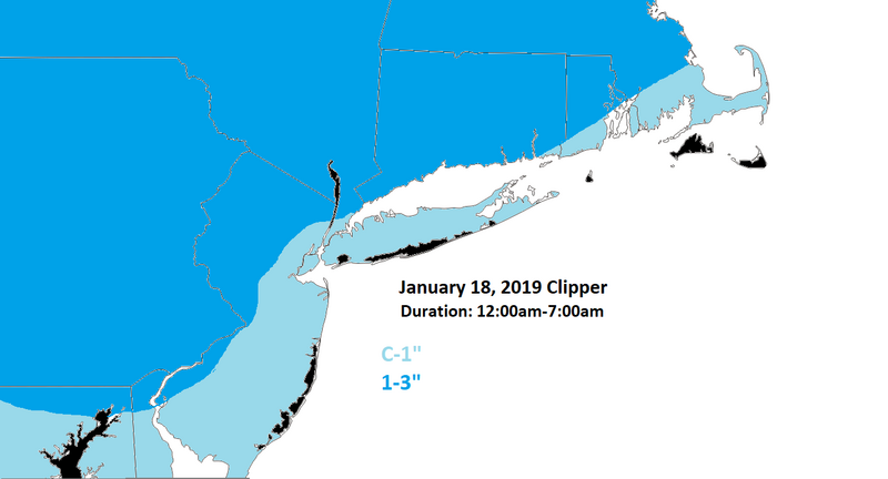
Fast moving system via the southern branch of the jet stream will
provide a taste of winter to begin the period. In general good model
agreement with precip timing, with the NAM still dragging its heels
a bit with precip onset. Ptype looks to be mainly snow through
Thursday night with a change over for to plain rain for far eastern
sections perhaps just before 12z Fri. The timing works out that the
Friday morning commute will be impacted to some degree with cold
ground temperatures to start so snow should stick on most surfaces.
For now thinking a general 1 to 2 inch snowfall, with less than an
inch far east, and perhaps in the 2 to 3 inch range in far
northwestern sections. The lift is not impressive with this system
as the southern branch energy is not consolidated well as there is
little backing in the mid levels to support liquid precipitation
amounts over a quarter inch. Therefore it makes sense that the
modeling by and large has lowered its QPF output over the past
couple of runs. The precipitation will change to plain rain as
warmer air noses in from the southeast in the lower levels during
Friday morning before it moves out shortly thereafter. Most places
should completely dry out by the late morning and towards lunch time
on Friday, with high pressure to follow briefly for Friday night into
early Saturday.
_________________
"In weather and in life, there's no winning and losing; there's only winning and learning."
WINTER 2012/2013 TOTALS 43.65"WINTER 2017/2018 TOTALS 62.85" WINTER 2022/2023 TOTALS 4.9"
WINTER 2013/2014 TOTALS 64.85"WINTER 2018/2019 TOTALS 14.25" WINTER 2023/2024 TOTALS 13.1"
WINTER 2014/2015 TOTALS 71.20"WINTER 2019/2020 TOTALS 6.35"
WINTER 2015/2016 TOTALS 35.00"WINTER 2020/2021 TOTALS 37.75"
WINTER 2016/2017 TOTALS 42.25"WINTER 2021/2022 TOTALS 31.65"

sroc4- Admin
- Posts : 8331
Reputation : 301
Join date : 2013-01-07
Location : Wading River, LI
Re: Thurs/Fri 1/17 -18 Clipper System
![]() by Guest Wed Jan 16, 2019 7:23 am
by Guest Wed Jan 16, 2019 7:23 am
Guest- Guest
Re: Thurs/Fri 1/17 -18 Clipper System
![]() by sroc4 Wed Jan 16, 2019 7:31 am
by sroc4 Wed Jan 16, 2019 7:31 am
syosnow94 wrote:I disagree Scott. They are still calling for a change to rain and a rainy morning except for N and W
Ummmmmm a sphincter says what? 12z Friday is about 7am. So with the exception of far eastern zones as stated Upton is calling for light snow to fall until approx. that time. By then the bulk of whats falling from this system, which isnt much QPF, is likely done. You read it differently?
Fast moving system via the southern branch of the jet stream will
provide a taste of winter to begin the period. In general good model
agreement with precip timing, with the NAM still dragging its heels
a bit with precip onset. Ptype looks to be mainly snow through
Thursday night with a change over for to plain rain for far eastern
sections perhaps just before 12z Fri. The timing works out that the
Friday morning commute will be impacted to some degree with cold
ground temperatures to start so snow should stick on most surfaces.
For now thinking a general 1 to 2 inch snowfall, with less than an
inch far east, and perhaps in the 2 to 3 inch range in far
northwestern sections. The lift is not impressive with this system
as the southern branch energy is not consolidated well as there is
little backing in the mid levels to support liquid precipitation
amounts over a quarter inch. Therefore it makes sense that the
modeling by and large has lowered its QPF output over the past
couple of runs. The precipitation will change to plain rain as
warmer air noses in from the southeast in the lower levels during
Friday morning before it moves out shortly thereafter. Most places
should completely dry out by the late morning and towards lunch time
on Friday,
_________________
"In weather and in life, there's no winning and losing; there's only winning and learning."
WINTER 2012/2013 TOTALS 43.65"WINTER 2017/2018 TOTALS 62.85" WINTER 2022/2023 TOTALS 4.9"
WINTER 2013/2014 TOTALS 64.85"WINTER 2018/2019 TOTALS 14.25" WINTER 2023/2024 TOTALS 13.1"
WINTER 2014/2015 TOTALS 71.20"WINTER 2019/2020 TOTALS 6.35"
WINTER 2015/2016 TOTALS 35.00"WINTER 2020/2021 TOTALS 37.75"
WINTER 2016/2017 TOTALS 42.25"WINTER 2021/2022 TOTALS 31.65"
sroc4- Admin
- Posts : 8331
Reputation : 301
Join date : 2013-01-07
Location : Wading River, LI
Re: Thurs/Fri 1/17 -18 Clipper System
![]() by Guest Wed Jan 16, 2019 8:39 am
by Guest Wed Jan 16, 2019 8:39 am
Guest- Guest
Re: Thurs/Fri 1/17 -18 Clipper System
![]() by amugs Wed Jan 16, 2019 8:41 am
by amugs Wed Jan 16, 2019 8:41 am
John Elliot just said this morning on 101.1 CBS radio - I think 2-3" for NNJ Suburbs with a possibly change to icy mix as yuo get closer to teh city and eastern LI would change to rain.
This s scalled CAD at work here folks and just wait till Monday morning - YIKES!!
_________________
Mugs
AKA:King: Snow Weenie
Self Proclaimed
WINTER 2014-15 : 55.12" +.02 for 6 coatings (avg. 35")
WINTER 2015-16 Total - 29.8" (Avg 35")
WINTER 2016-17 : 39.5" so far

amugs- Advanced Forecaster - Mod
- Posts : 15093
Reputation : 213
Join date : 2013-01-07
Age : 54
Location : Hillsdale,NJ
Re: Thurs/Fri 1/17 -18 Clipper System
![]() by Frank_Wx Wed Jan 16, 2019 12:38 pm
by Frank_Wx Wed Jan 16, 2019 12:38 pm
_________________
_______________________________________________________________________________________________________
CLICK HERE to view NJ Strong Snowstorm Classifications
Frank_Wx- Godzilla Seeker
- Posts : 21305
Reputation : 328
Join date : 2013-01-05
Age : 31
Location : Jersey City, NJ -
Re: Thurs/Fri 1/17 -18 Clipper System
![]() by Guest Wed Jan 16, 2019 1:08 pm
by Guest Wed Jan 16, 2019 1:08 pm
Guest- Guest
Re: Thurs/Fri 1/17 -18 Clipper System
![]() by Guest Wed Jan 16, 2019 1:09 pm
by Guest Wed Jan 16, 2019 1:09 pm
Guest- Guest
Re: Thurs/Fri 1/17 -18 Clipper System
![]() by Guest Wed Jan 16, 2019 1:10 pm
by Guest Wed Jan 16, 2019 1:10 pm
TheAresian wrote:No dessert unless you have your supper first, Syo.
Supper? This is like a half of of cracker
Guest- Guest
Re: Thurs/Fri 1/17 -18 Clipper System
![]() by Guest Wed Jan 16, 2019 1:13 pm
by Guest Wed Jan 16, 2019 1:13 pm
Guest- Guest
Page 2 of 3 • 1, 2, 3 ![]()