May 2019 Observations and Discussion
+17
weatherwatchermom
Grselig
brownie
hyde345
amugs
dkodgis
sroc4
Snow88
frank 638
Dunnzoo
docstox12
rb924119
skinsfan1177
jmanley32
1190ftalt
billg315
Quietace
21 posters
Page 4 of 4 •  1, 2, 3, 4
 Re: May 2019 Observations and Discussion
In Stillwater Nj, the second part coming thru, sounds like it is south towards DWG!
1190ftalt- Pro Enthusiast

- Posts : 401
Join date : 2013-12-13
 Re: May 2019 Observations and Discussion
Lightning and thunder in St. James, NY
aiannone- Senior Enthusiast - Mod

- Posts : 4815
Join date : 2013-01-07
 Re: May 2019 Observations and Discussion
NYC under severe thunderstorm warning newark in path of storm in morris, funnel cloud has been spotted per news 4. I would not be surprised to see NYC ina tornado warning within the hour.

jmanley32- Senior Enthusiast

- Posts : 20535
Reputation : 108
Join date : 2013-12-12
Age : 43
Location : Yonkers, NY
 Re: May 2019 Observations and Discussion
jmanley32 wrote:NYC under severe thunderstorm warning newark in path of storm in morris, funnel cloud has been spotted per news 4. I would not be surprised to see NYC ina tornado warning within the hour.
Not sure you will get one in NYC. Staten Island in warning

skinsfan1177- Senior Enthusiast

- Posts : 4485
Reputation : 35
Join date : 2013-01-07
Age : 46
Location : Point Pleasant Boro
 Re: May 2019 Observations and Discussion
Tornado warning has gone up
For lower Manhattan and Staten island .by me there is crazy lighting for about 10 minutes with light rain
For lower Manhattan and Staten island .by me there is crazy lighting for about 10 minutes with light rain
frank 638- Senior Enthusiast

- Posts : 2843
Reputation : 37
Join date : 2016-01-01
Age : 40
Location : bronx ny
 Re: May 2019 Observations and Discussion
really frank no lightning here, so weird how so close yet so far. Does not look like my area will see anything, as per usual.

jmanley32- Senior Enthusiast

- Posts : 20535
Reputation : 108
Join date : 2013-12-12
Age : 43
Location : Yonkers, NY
 Re: May 2019 Observations and Discussion
that's strange because we are not to far from each other before it was just lightning after lightning we didn't get that much rain I'm surprised they didn't even delay the Yankee gamejmanley32 wrote:really frank no lightning here, so weird how so close yet so far. Does not look like my area will see anything, as per usual.
frank 638- Senior Enthusiast

- Posts : 2843
Reputation : 37
Join date : 2016-01-01
Age : 40
Location : bronx ny
 Re: May 2019 Observations and Discussion
My nieces school might have been hit by a tornado.... 

weatherwatchermom- Senior Enthusiast

- Posts : 3793
Reputation : 78
Join date : 2014-11-25
Location : Hazlet Township, NJ
 Re: May 2019 Observations and Discussion
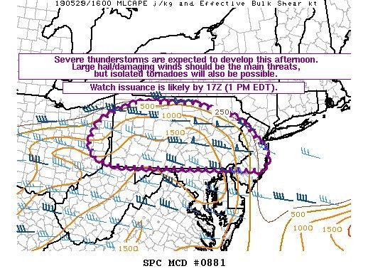
Updated 1300z discussion from SPC:
...Upper Ohio Valley/central Appalachians to Mid-Atlantic...
A convectively enhanced shortwave trough approaching Lake Erie this
morning will continue eastward and cross Pennsylvania and the
coastal Northeast this afternoon/early evening in conjunction with a
belt of strengthening mid-level winds (50-70 kt at 500 mb). As the
air mass steadily destabilizes and inhibition erodes by afternoon,
scattered thunderstorms are expected to develop and intensify as
early as midday across Pennsylvania, and subsequently spread
into/across adjacent parts of New Jersey, Maryland, Delaware, and
northern Virginia.
With the air mass likely to become moderately unstable by afternoon,
storms will quickly intensify, organizationally aided by the
intensifying belt of strong westerly deep-layer flow across the
area. Large hail and damaging winds can be expected. Some tornado
risk may also exist, particularly across eastern Pennsylvania/New
Jersey southward toward the Delmarva vicinity, in relatively close
proximity to a surface low and adjacent warm front. A supercell risk
aside, at least loosely organized clusters/bands of
east/southeastward-moving storms should evolve across most of the
region, which carries with it the potential for a relatively
widespread wind risk to evolve as storms spread toward the I-95
corridor/coastal areas.
Farther to the south/southwest, a bit removed from the strongest
westerlies aloft, a cluster of storms moving out of southern
Illinois/Indiana (and other preceding development) and others
crossing the Mississippi River could persist generally eastward
today across Kentucky/southern Ohio into West Virginia and
eventually western Virginia. A warm/unstable downstream environment
would support the potential for damaging winds within this regional
corridor.
Like
Quote

skinsfan1177- Senior Enthusiast

- Posts : 4485
Reputation : 35
Join date : 2013-01-07
Age : 46
Location : Point Pleasant Boro
 Re: May 2019 Observations and Discussion
100 F yesterday. 99F the 4 prior days. Hot again today. 


Quietace- Meteorologist - Mod

- Posts : 3689
Reputation : 33
Join date : 2013-01-07
Age : 27
Location : Point Pleasant, NJ

skinsfan1177- Senior Enthusiast

- Posts : 4485
Reputation : 35
Join date : 2013-01-07
Age : 46
Location : Point Pleasant Boro
 Re: May 2019 Observations and Discussion
3 pm and the sky is getting eerily darker. I expect it will blow pretty good. Last night AKA earlier this morning about 1:30 am it was pouring. Air is still. Not a leaf moving. You know it is coming, just not when but when it does come, I bet we will get our money's worth.

dkodgis- Senior Enthusiast

- Posts : 2560
Reputation : 98
Join date : 2013-12-29
 Re: May 2019 Observations and Discussion
Looking at the Acuweather radar, some pretty heavy stuff may come through. Cloudy with a slight breeze right now. Rooting for nice heavy and loud thunderstorms, but very much against tornados.

Grselig- Senior Enthusiast

- Posts : 1408
Reputation : 140
Join date : 2013-03-04
Age : 54
Location : Wayne NJ
 Re: May 2019 Observations and Discussion
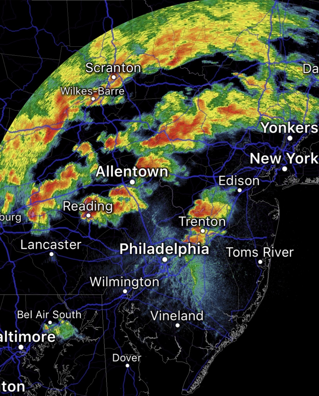
Radar over PA and northern New Jersey is lit up like a Christmas Tree. Scattered storms out front and a more solid line of severe storms from the Susquehanna Valley in PA up to near Binghamton. A Tornado WARNING just issued for a cell near Flemington and Montgomery New Jersey.
Going to be an active evening folks. I think we will see a lot of reports of wind damage, flooding and power outages. Time frame is now until about 10 p.m.
Going to be an active evening folks. I think we will see a lot of reports of wind damage, flooding and power outages. Time frame is now until about 10 p.m.

billg315- Advanced Forecaster - Mod

- Posts : 4483
Reputation : 185
Join date : 2015-01-24
Age : 50
Location : Flemington, NJ

billg315- Advanced Forecaster - Mod

- Posts : 4483
Reputation : 185
Join date : 2015-01-24
Age : 50
Location : Flemington, NJ
 Re: May 2019 Observations and Discussion
First of a couple potent lines coming through here now. Very heavy rain, lots of thunder. Winds are gusty but not crazy . . . At least so far. Looking at radar this will go on for quite some time here as subsequent lines sweep in.

billg315- Advanced Forecaster - Mod

- Posts : 4483
Reputation : 185
Join date : 2015-01-24
Age : 50
Location : Flemington, NJ
 Re: May 2019 Observations and Discussion
storms are starting to hit

weatherwatchermom- Senior Enthusiast

- Posts : 3793
Reputation : 78
Join date : 2014-11-25
Location : Hazlet Township, NJ
 Re: May 2019 Observations and Discussion
Like I said earlier CNJ in a good spot for severe storms here we go

skinsfan1177- Senior Enthusiast

- Posts : 4485
Reputation : 35
Join date : 2013-01-07
Age : 46
Location : Point Pleasant Boro
 Re: May 2019 Observations and Discussion
Not as bad as yesterday by me . At 5:30 it got really dark it poured for maybe 20 minutes with some lightning and thunder no wind no hell nothing crazy now it's moderate rain . I just hope everyone is doing okay
frank 638- Senior Enthusiast

- Posts : 2843
Reputation : 37
Join date : 2016-01-01
Age : 40
Location : bronx ny
 Re: May 2019 Observations and Discussion
Heavy rain and some lightning. Nothing memorable. But it looks like it hit worse in southern NJ. Hope nothing serious.

Grselig- Senior Enthusiast

- Posts : 1408
Reputation : 140
Join date : 2013-03-04
Age : 54
Location : Wayne NJ
 Re: May 2019 Observations and Discussion
.11" of rain yesterday, .84" of rain today. No wind, a few rumbles of thunder and that's it.
_________________
Janet
Snowfall winter of 2023-2024 17.5"
Snowfall winter of 2022-2023 6.0"
Snowfall winter of 2021-2022 17.6" 1" sleet 2/25/22
Snowfall winter of 2020-2021 51.1"
Snowfall winter of 2019-2020 8.5"
Snowfall winter of 2018-2019 25.1"
Snowfall winter of 2017-2018 51.9"
Snowfall winter of 2016-2017 45.6"
Snowfall winter of 2015-2016 29.5"
Snowfall winter of 2014-2015 50.55"
Snowfall winter of 2013-2014 66.5"
Dunnzoo- Senior Enthusiast - Mod

- Posts : 4905
Reputation : 68
Join date : 2013-01-11
Age : 62
Location : Westwood, NJ
 Re: May 2019 Observations and Discussion
Yes, it was one of those times yesterday for me that it rumbled but little rain and no win. It was all cackle and no eggs. This lovely morning, 57 and overcast. I see more rain in the forecast.
Seattle ain't got nothing on us regarding rain.
Seattle ain't got nothing on us regarding rain.

dkodgis- Senior Enthusiast

- Posts : 2560
Reputation : 98
Join date : 2013-12-29
 Re: May 2019 Observations and Discussion
For the past 2 hours it has been pouring rain Non-Stop I probably received an inch or more of rain
frank 638- Senior Enthusiast

- Posts : 2843
Reputation : 37
Join date : 2016-01-01
Age : 40
Location : bronx ny
 Re: May 2019 Observations and Discussion
Got 1.06" so far with more coming in later...
_________________
Janet
Snowfall winter of 2023-2024 17.5"
Snowfall winter of 2022-2023 6.0"
Snowfall winter of 2021-2022 17.6" 1" sleet 2/25/22
Snowfall winter of 2020-2021 51.1"
Snowfall winter of 2019-2020 8.5"
Snowfall winter of 2018-2019 25.1"
Snowfall winter of 2017-2018 51.9"
Snowfall winter of 2016-2017 45.6"
Snowfall winter of 2015-2016 29.5"
Snowfall winter of 2014-2015 50.55"
Snowfall winter of 2013-2014 66.5"

Dunnzoo- Senior Enthusiast - Mod

- Posts : 4905
Reputation : 68
Join date : 2013-01-11
Age : 62
Location : Westwood, NJ
 Re: May 2019 Observations and Discussion
I know this has to be a mistake next Thursday news 12 traffic and weather has my area for tstorms with a high of 78 and a low of 35 deg
frank 638- Senior Enthusiast

- Posts : 2843
Reputation : 37
Join date : 2016-01-01
Age : 40
Location : bronx ny
Page 4 of 4 •  1, 2, 3, 4
Permissions in this forum:
You cannot reply to topics in this forum|
|
|

 Home
Home