
 Search
July 2014 Observations / Discussions Thread
Page 8 of 11 •  1, 2, 3 ... 7, 8, 9, 10, 11
 ![]()
Re: July 2014 Observations / Discussions Thread
![]() by algae888 Sat Jul 26, 2014 6:49 pm
by algae888 Sat Jul 26, 2014 6:49 pm
algae888- Advanced Forecaster

- Posts : 5311
Join date : 2013-02-05
Re: July 2014 Observations / Discussions Thread
![]() by amugs Sat Jul 26, 2014 9:47 pm
by amugs Sat Jul 26, 2014 9:47 pm

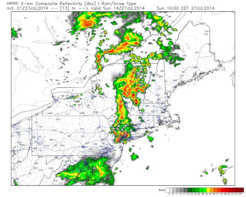
HRRR says a good line of storms for tomorrow evening - if we get storms in the morning than the atmosphere will most likely not produce these and destabilize the severe threat like our boy wonder Ace and illustrious leader Frank have pointed out.
amugs- Advanced Forecaster - Mod

- Posts : 15093
Join date : 2013-01-07
Re: July 2014 Observations / Discussions Thread
![]() by jmanley32 Sat Jul 26, 2014 11:54 pm
by jmanley32 Sat Jul 26, 2014 11:54 pm

jmanley32- Senior Enthusiast

- Posts : 20517
Reputation : 108
Join date : 2013-12-12
Age : 42
Location : Yonkers, NY
Re: July 2014 Observations / Discussions Thread
![]() by algae888 Sun Jul 27, 2014 7:56 am
by algae888 Sun Jul 27, 2014 7:56 am

algae888- Advanced Forecaster
- Posts : 5311
Reputation : 46
Join date : 2013-02-05
Age : 61
Location : mt. vernon, new york
Re: July 2014 Observations / Discussions Thread
![]() by algae888 Sun Jul 27, 2014 8:34 am
by algae888 Sun Jul 27, 2014 8:34 am
algae888- Advanced Forecaster
- Posts : 5311
Reputation : 46
Join date : 2013-02-05
Age : 61
Location : mt. vernon, new york
Re: July 2014 Observations / Discussions Thread
![]() by Quietace Sun Jul 27, 2014 8:37 am
by Quietace Sun Jul 27, 2014 8:37 am

Quietace- Meteorologist - Mod

- Posts : 3687
Reputation : 33
Join date : 2013-01-07
Age : 27
Location : Point Pleasant, NJ
Re: July 2014 Observations / Discussions Thread
![]() by jmanley32 Sun Jul 27, 2014 9:09 am
by jmanley32 Sun Jul 27, 2014 9:09 am
jmanley32- Senior Enthusiast
- Posts : 20517
Reputation : 108
Join date : 2013-12-12
Age : 42
Location : Yonkers, NY
Re: July 2014 Observations / Discussions Thread
![]() by jmanley32 Sun Jul 27, 2014 9:24 am
by jmanley32 Sun Jul 27, 2014 9:24 am
jmanley32- Senior Enthusiast
- Posts : 20517
Reputation : 108
Join date : 2013-12-12
Age : 42
Location : Yonkers, NY
Re: July 2014 Observations / Discussions Thread
![]() by algae888 Sun Jul 27, 2014 9:26 am
by algae888 Sun Jul 27, 2014 9:26 am
algae888- Advanced Forecaster
- Posts : 5311
Reputation : 46
Join date : 2013-02-05
Age : 61
Location : mt. vernon, new york
Re: July 2014 Observations / Discussions Thread
![]() by amugs Sun Jul 27, 2014 9:45 am
by amugs Sun Jul 27, 2014 9:45 am
Had a shower this morning and sun trying to break through.
_________________
Mugs
AKA:King: Snow Weenie
Self Proclaimed
WINTER 2014-15 : 55.12" +.02 for 6 coatings (avg. 35")
WINTER 2015-16 Total - 29.8" (Avg 35")
WINTER 2016-17 : 39.5" so far

amugs- Advanced Forecaster - Mod
- Posts : 15093
Reputation : 213
Join date : 2013-01-07
Age : 54
Location : Hillsdale,NJ
Re: July 2014 Observations / Discussions Thread
![]() by jmanley32 Sun Jul 27, 2014 9:57 am
by jmanley32 Sun Jul 27, 2014 9:57 am

jmanley32- Senior Enthusiast
- Posts : 20517
Reputation : 108
Join date : 2013-12-12
Age : 42
Location : Yonkers, NY
Re: July 2014 Observations / Discussions Thread
![]() by jmanley32 Sun Jul 27, 2014 10:00 am
by jmanley32 Sun Jul 27, 2014 10:00 am
jmanley32- Senior Enthusiast
- Posts : 20517
Reputation : 108
Join date : 2013-12-12
Age : 42
Location : Yonkers, NY
jmanley32- Senior Enthusiast
- Posts : 20517
Reputation : 108
Join date : 2013-12-12
Age : 42
Location : Yonkers, NY
Re: July 2014 Observations / Discussions Thread
![]() by Quietace Sun Jul 27, 2014 10:36 am
by Quietace Sun Jul 27, 2014 10:36 am
Quietace- Meteorologist - Mod
- Posts : 3687
Reputation : 33
Join date : 2013-01-07
Age : 27
Location : Point Pleasant, NJ
Re: July 2014 Observations / Discussions Thread
![]() by Frank_Wx Sun Jul 27, 2014 10:37 am
by Frank_Wx Sun Jul 27, 2014 10:37 am
_________________
_______________________________________________________________________________________________________
CLICK HERE to view NJ Strong Snowstorm Classifications

Frank_Wx- Godzilla Seeker

- Posts : 21305
Reputation : 328
Join date : 2013-01-05
Age : 31
Location : Jersey City, NJ -

Re: July 2014 Observations / Discussions Thread
![]() by jmanley32 Sun Jul 27, 2014 11:07 am
by jmanley32 Sun Jul 27, 2014 11:07 am
jmanley32- Senior Enthusiast
- Posts : 20517
Reputation : 108
Join date : 2013-12-12
Age : 42
Location : Yonkers, NY
Re: July 2014 Observations / Discussions Thread
![]() by jmanley32 Sun Jul 27, 2014 2:39 pm
by jmanley32 Sun Jul 27, 2014 2:39 pm
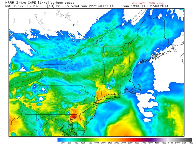
Currently Cape around NYC area 1376, helicity 50, effective shear 39, and into yellow instability on this page: BTW thanks frank great page.
http://www.spc.noaa.gov/exper/mesoanalysis/new/viewsector.php?sector=16#
I noticed that when the main part of storms come into area they are in a horizontal like moving from south to north, this is odd, is that going to spark more violent storms/tornados? Tornados look unlikely but SPC still has us under a 5% chance. Cape appears to stay near 1500-2000 almost all night with a bullseye right over southern westchester. BTW this is all per the HRRR, wasn't right this morning so could be wrong for tonight but this morning didn't really seem plausible anyways.
jmanley32- Senior Enthusiast
- Posts : 20517
Reputation : 108
Join date : 2013-12-12
Age : 42
Location : Yonkers, NY
Re: July 2014 Observations / Discussions Thread
![]() by algae888 Sun Jul 27, 2014 4:06 pm
by algae888 Sun Jul 27, 2014 4:06 pm
algae888- Advanced Forecaster
- Posts : 5311
Reputation : 46
Join date : 2013-02-05
Age : 61
Location : mt. vernon, new york
Re: July 2014 Observations / Discussions Thread
![]() by jmanley32 Sun Jul 27, 2014 4:15 pm
by jmanley32 Sun Jul 27, 2014 4:15 pm

jmanley32- Senior Enthusiast
- Posts : 20517
Reputation : 108
Join date : 2013-12-12
Age : 42
Location : Yonkers, NY
Re: July 2014 Observations / Discussions Thread
![]() by Frank_Wx Sun Jul 27, 2014 4:30 pm
by Frank_Wx Sun Jul 27, 2014 4:30 pm
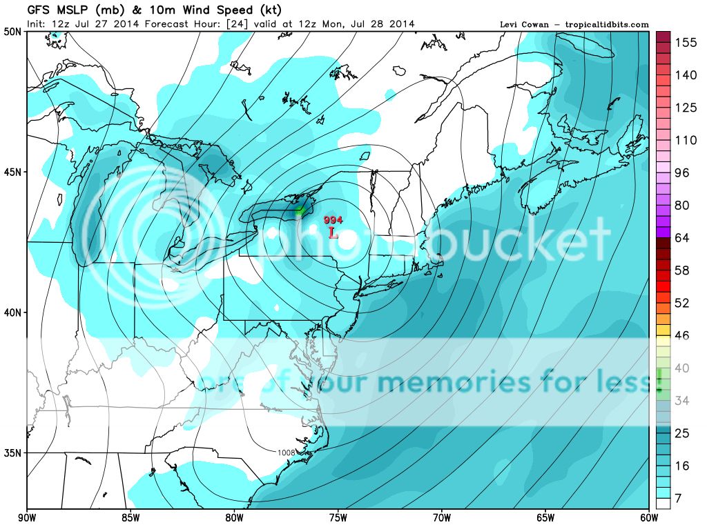
As you can see, that is expected to pass through NW PA then make a sharp turn to the northeast.

It may not look like it now, but once that vort takes the turn north and east, the areas of convection circulating around it also take the turn north. Areas north of NYC are in line to see some pretty good storms tonight.
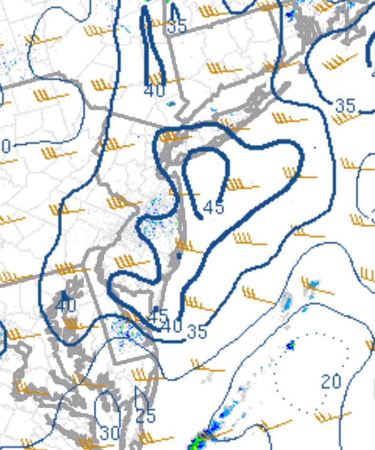
Bulk shear is diminishing as well. Now down to 40KT in NYC, 35kt just west.
I guess one thing to look for is possible cells developing ahead of the vort, as the HRRR suggest, but with severe weather parameters diminishing for our area I wouldn't expect those storms to come of the severe variety.
_________________
_______________________________________________________________________________________________________
CLICK HERE to view NJ Strong Snowstorm Classifications
Frank_Wx- Godzilla Seeker
- Posts : 21305
Reputation : 328
Join date : 2013-01-05
Age : 31
Location : Jersey City, NJ -
Re: July 2014 Observations / Discussions Thread
![]() by jmanley32 Sun Jul 27, 2014 4:35 pm
by jmanley32 Sun Jul 27, 2014 4:35 pm
jmanley32- Senior Enthusiast
- Posts : 20517
Reputation : 108
Join date : 2013-12-12
Age : 42
Location : Yonkers, NY
Re: July 2014 Observations / Discussions Thread
![]() by Frank_Wx Sun Jul 27, 2014 4:38 pm
by Frank_Wx Sun Jul 27, 2014 4:38 pm
jmanley32 wrote:I am confused Frank it appears on the page that you sent me that the n umbers are going up over here in the southern westchester area. I thought it was destabilizing, but you point to the opposite. Am I reading the maps wrong?
No, you were correct. This is a timing issue though. Even though parameters are favorable now, the space between where the vort is currently located and our area is too wide. By the time it gets near us, not only will it be to our northwest, but the sun will be down by then.
_________________
_______________________________________________________________________________________________________
CLICK HERE to view NJ Strong Snowstorm Classifications
Frank_Wx- Godzilla Seeker
- Posts : 21305
Reputation : 328
Join date : 2013-01-05
Age : 31
Location : Jersey City, NJ -
Re: July 2014 Observations / Discussions Thread
![]() by jmanley32 Sun Jul 27, 2014 4:41 pm
by jmanley32 Sun Jul 27, 2014 4:41 pm
jmanley32- Senior Enthusiast
- Posts : 20517
Reputation : 108
Join date : 2013-12-12
Age : 42
Location : Yonkers, NY
Re: July 2014 Observations / Discussions Thread
![]() by jmanley32 Sun Jul 27, 2014 4:43 pm
by jmanley32 Sun Jul 27, 2014 4:43 pm
jmanley32- Senior Enthusiast
- Posts : 20517
Reputation : 108
Join date : 2013-12-12
Age : 42
Location : Yonkers, NY
Re: July 2014 Observations / Discussions Thread
![]() by Frank_Wx Sun Jul 27, 2014 4:44 pm
by Frank_Wx Sun Jul 27, 2014 4:44 pm
Yes, severe weather parameters are favorable NOW, but like I just said, it doesn't matter because the main low pressure is still too far away. By the time it gets here, all those parameters you just pointed out will look much different.
_________________
_______________________________________________________________________________________________________
CLICK HERE to view NJ Strong Snowstorm Classifications
Frank_Wx- Godzilla Seeker
- Posts : 21305
Reputation : 328
Join date : 2013-01-05
Age : 31
Location : Jersey City, NJ -
Re: July 2014 Observations / Discussions Thread
![]() by jmanley32 Sun Jul 27, 2014 4:45 pm
by jmanley32 Sun Jul 27, 2014 4:45 pm
jmanley32- Senior Enthusiast
- Posts : 20517
Reputation : 108
Join date : 2013-12-12
Age : 42
Location : Yonkers, NY
Re: July 2014 Observations / Discussions Thread
![]() by Frank_Wx Sun Jul 27, 2014 4:48 pm
by Frank_Wx Sun Jul 27, 2014 4:48 pm
jmanley32 wrote:I just reposted to you, I am paying attention, I missed your post because the thread went onto a new page sorry bout that. 10/4 on what your explaining.
Oh yea, I hate when that happens.
There never was a chance for severe weather, in my opinion. I've been pretty firm on that.
_________________
_______________________________________________________________________________________________________
CLICK HERE to view NJ Strong Snowstorm Classifications
Frank_Wx- Godzilla Seeker
- Posts : 21305
Reputation : 328
Join date : 2013-01-05
Age : 31
Location : Jersey City, NJ -
Page 8 of 11 • 1, 2, 3 ... 7, 8, 9, 10, 11 ![]()
|
|
|