Official Long Range Thread 4.0
+29
Snow88
carvin1079
Artechmetals
Vinnydula
Isotherm
Radz
Quietace
CPcantmeasuresnow
1190ftalt
HectorO
devsman
aiannone
NjWeatherGuy
Analog96
nutleyblizzard
Math23x7
dsix85
Sunflowers138
skinsfan1177
amugs
mako460
rb924119
SoulSingMG
Dunnzoo
sroc4
algae888
jmanley32
docstox12
Frank_Wx
33 posters
Page 1 of 42
Page 1 of 42 • 1, 2, 3 ... 21 ... 42 
 Official Long Range Thread 4.0
Happy Halloween 
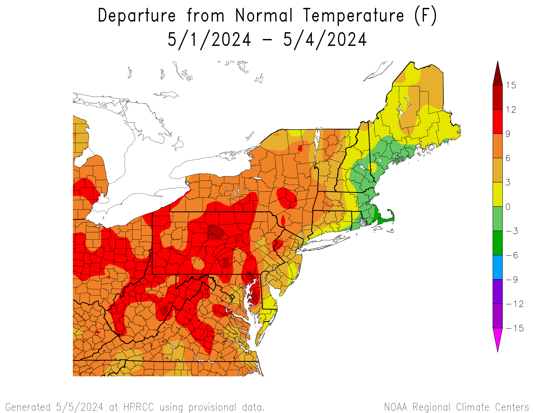
Though this graphic is missing the last 2 days of October, the overall theme of the month in the northeast was above normal temp departures. Most areas probably fall into the +1 to +2 category, which is what I predicted earlier this month. Some will argue the upper air pattern was transient. I would agree with them. It just happened to be the warmer temp. departures beat out the colder ones.

The transience is going to continue into November. This weekend we will experience below normal temps. as a sharp mid-level trough moves in followed by the same ridge that is one of the culprits for shunning our coastal storm out to sea on Saturday. Under the trough, we may see temps. not get out of the 40's on Sunday. Under the ridge, expected to move in Tuesday, temps. will get into the 60's. By the end of next week, another trough moves in and the roller coaster ride of temperatures continues.
By the 2nd week of November, guidance is suggesting the pattern remains progressive. You can see that from the 00z GEFS below:

The 12z EURO OP was also suggesting the same thing with a large trough developing over the Aleutians. I think since the pattern is still in a state of flux with all these evolving phenomena's (+ENSO, warming Stratosphere, NH snow cover) it will continue to go through these mood swings that will pretty much keep us in a mainly above normal temp. regime with some below normal days mixed in.
Therefore, I am predicting Nov. to end +1.5 to +2.5 for the NYC region.
Though this graphic is missing the last 2 days of October, the overall theme of the month in the northeast was above normal temp departures. Most areas probably fall into the +1 to +2 category, which is what I predicted earlier this month. Some will argue the upper air pattern was transient. I would agree with them. It just happened to be the warmer temp. departures beat out the colder ones.

The transience is going to continue into November. This weekend we will experience below normal temps. as a sharp mid-level trough moves in followed by the same ridge that is one of the culprits for shunning our coastal storm out to sea on Saturday. Under the trough, we may see temps. not get out of the 40's on Sunday. Under the ridge, expected to move in Tuesday, temps. will get into the 60's. By the end of next week, another trough moves in and the roller coaster ride of temperatures continues.
By the 2nd week of November, guidance is suggesting the pattern remains progressive. You can see that from the 00z GEFS below:

The 12z EURO OP was also suggesting the same thing with a large trough developing over the Aleutians. I think since the pattern is still in a state of flux with all these evolving phenomena's (+ENSO, warming Stratosphere, NH snow cover) it will continue to go through these mood swings that will pretty much keep us in a mainly above normal temp. regime with some below normal days mixed in.
Therefore, I am predicting Nov. to end +1.5 to +2.5 for the NYC region.
_________________
_______________________________________________________________________________________________________
CLICK HERE to view NJ Strong Snowstorm Classifications
 Re: Official Long Range Thread 4.0
Good call on the Oct. temps, Frank. Won't mind a milder month of Nov. to make it easier to clean up the leaves falling.Get the warm weather out of the way in Oct. and Nov. rather than Jan. and Feb.

docstox12- Wx Statistician Guru

- Posts : 8504
Reputation : 222
Join date : 2013-01-07
Age : 73
Location : Monroe NY
 Re: Official Long Range Thread 4.0
Looks like we will have another storm to track for around the 7th time frame, hmmm 2012 snowstorm anyone? LOL I doubt we get early snow this year of any significance.

jmanley32- Senior Enthusiast

- Posts : 20516
Reputation : 108
Join date : 2013-12-12
Age : 42
Location : Yonkers, NY
 Re: Official Long Range Thread 4.0
frank this weekend we are going to be about 10* below normal followed by a brief warm up and then another cold shot next weekend. so after 10 days we should be slightly below normal. if we end up nov. at +1.5 to 2.5 then the middle and end of nov will have to well above ave. are you calling for that? my thinking is that we will be at or a little below normal for month. possibly colder. why? starting to see pattern evolve into a winter time pattern. pna is looking to spike around the 10th and ao also looks to be tanking again around that time.

algae888- Advanced Forecaster

- Posts : 5311
Reputation : 46
Join date : 2013-02-05
Age : 61
Location : mt. vernon, new york
 Re: Official Long Range Thread 4.0
jmanley32 wrote:Looks like we will have another storm to track for around the 7th time frame, hmmm 2012 snowstorm anyone? LOL I doubt we get early snow this year of any significance.
yes jman cmc has another neg tilted trough with coastal low bombing out next Friday off nj coast. euro and gfs has weaker trough and low further north. something to watch.

algae888- Advanced Forecaster

- Posts : 5311
Reputation : 46
Join date : 2013-02-05
Age : 61
Location : mt. vernon, new york
 Re: Official Long Range Thread 4.0
the pna will be spiking and ao tanking. noa going from positive to neutral. so tele conn. maybe right for another coastal. I like how we are getting coastals to form. hopefully this is a sign for our winter season

algae888- Advanced Forecaster

- Posts : 5311
Reputation : 46
Join date : 2013-02-05
Age : 61
Location : mt. vernon, new york
 Re: Official Long Range Thread 4.0
One thing to keep in mind is that November is notorious for models to go a little haywire as they transition from Fall to Winter pattern. You may see drastic changes from run to run. My above normal forecast comes mainly from the unfavorable pattern in the Pacific, which Ithink will promote some ridging on the east coast
_________________
_______________________________________________________________________________________________________
CLICK HERE to view NJ Strong Snowstorm Classifications
 Re: Official Long Range Thread 4.0
Frank what do you think about the possibility of a strom in next weekends time frame? Accuwx has rain and wing gusts to 60mph for the 9-10th, not sure where they are getting that from and usually their forecasts past one day change drastically.

jmanley32- Senior Enthusiast

- Posts : 20516
Reputation : 108
Join date : 2013-12-12
Age : 42
Location : Yonkers, NY
 Re: Official Long Range Thread 4.0
The Euro weeklies have us warm through the end of November.I don't believe that's going to happen. Euro also had us warm for this week which is going to end up being near average. as Frank has stated models having a tough time with the changing pattern.

algae888- Advanced Forecaster

- Posts : 5311
Reputation : 46
Join date : 2013-02-05
Age : 61
Location : mt. vernon, new york
 Re: Official Long Range Thread 4.0
Well if the GEFS and EURO ENS are right, then a -EPO/+PNA pattern returns after the 1st week of November
The ECMWF Ens


The ECMWF Ens


_________________
_______________________________________________________________________________________________________
CLICK HERE to view NJ Strong Snowstorm Classifications
 Re: Official Long Range Thread 4.0
That's the same pattern that drove our winter last season.
_________________
_______________________________________________________________________________________________________
CLICK HERE to view NJ Strong Snowstorm Classifications
 Re: Official Long Range Thread 4.0
Watch for a MECS in mid Nov
_________________
"In weather and in life, there's no winning and losing; there's only winning and learning."
WINTER 2012/2013 TOTALS 43.65"WINTER 2017/2018 TOTALS 62.85" WINTER 2022/2023 TOTALS 4.9"
WINTER 2013/2014 TOTALS 64.85"WINTER 2018/2019 TOTALS 14.25" WINTER 2023/2024 TOTALS 13.1"
WINTER 2014/2015 TOTALS 71.20"WINTER 2019/2020 TOTALS 6.35"
WINTER 2015/2016 TOTALS 35.00"WINTER 2020/2021 TOTALS 37.75"
WINTER 2016/2017 TOTALS 42.25"WINTER 2021/2022 TOTALS 31.65"

sroc4- Admin

- Posts : 8331
Reputation : 301
Join date : 2013-01-07
Location : Wading River, LI
 Re: Official Long Range Thread 4.0
Scott going bold. Watch out people.
_________________
_______________________________________________________________________________________________________
CLICK HERE to view NJ Strong Snowstorm Classifications
 Re: Official Long Range Thread 4.0
Scott was that a joke or are u serious? You god my blood percolating on that one, that would be pretty rare wouldn't it?

jmanley32- Senior Enthusiast

- Posts : 20516
Reputation : 108
Join date : 2013-12-12
Age : 42
Location : Yonkers, NY
 Re: Official Long Range Thread 4.0
latest snow cover for north america and eurasia. as of yesterday
http://www.climate4you.com/SnowCover.htm
besides expansive snow cover in Eurasia most of Canada now snow covered. the implications of this (esp the Canadian snow cover) is that cold air coming south should not modify as much as usual and will we likely feel the brunt of the cold air.
http://www.climate4you.com/SnowCover.htm
besides expansive snow cover in Eurasia most of Canada now snow covered. the implications of this (esp the Canadian snow cover) is that cold air coming south should not modify as much as usual and will we likely feel the brunt of the cold air.

algae888- Advanced Forecaster

- Posts : 5311
Reputation : 46
Join date : 2013-02-05
Age : 61
Location : mt. vernon, new york
 Re: Official Long Range Thread 4.0
jmanley32 wrote:Scott was that a joke or are u serious? You god my blood percolating on that one, that would be pretty rare wouldn't it?
Very serious. A signal for one is percolating but still a LOONNNGGG way off. I wouldnt go beyond that at this stage obviously. For now monitor the H5 anomaly charts for the consistency for the signal.
_________________
"In weather and in life, there's no winning and losing; there's only winning and learning."
WINTER 2012/2013 TOTALS 43.65"WINTER 2017/2018 TOTALS 62.85" WINTER 2022/2023 TOTALS 4.9"
WINTER 2013/2014 TOTALS 64.85"WINTER 2018/2019 TOTALS 14.25" WINTER 2023/2024 TOTALS 13.1"
WINTER 2014/2015 TOTALS 71.20"WINTER 2019/2020 TOTALS 6.35"
WINTER 2015/2016 TOTALS 35.00"WINTER 2020/2021 TOTALS 37.75"
WINTER 2016/2017 TOTALS 42.25"WINTER 2021/2022 TOTALS 31.65"

sroc4- Admin

- Posts : 8331
Reputation : 301
Join date : 2013-01-07
Location : Wading River, LI
 Re: Official Long Range Thread 4.0
if you follow the snow cover starting from Alaska and draw a line through it diagonally it looks like it's making a bee line right towards us. wonder if that will influence the air flow at all? would be great for us.

algae888- Advanced Forecaster

- Posts : 5311
Reputation : 46
Join date : 2013-02-05
Age : 61
Location : mt. vernon, new york
 Re: Official Long Range Thread 4.0

Madonne. Compared to last year this is nuts
_________________
_______________________________________________________________________________________________________
CLICK HERE to view NJ Strong Snowstorm Classifications
 Re: Official Long Range Thread 4.0
A mecs snowstorm or mecs unsure of precip type? So when around 15 to 20th timeframe? I know it's just signals but wanted to know what timeframe ur seeing these signals. U go for the god scott!

jmanley32- Senior Enthusiast

- Posts : 20516
Reputation : 108
Join date : 2013-12-12
Age : 42
Location : Yonkers, NY
 Re: Official Long Range Thread 4.0
http://www.cnrfc.noaa.gov/model_loops/12zgfs_namer_pcp.php
todays 12z gfs hr 204. hmmm!
todays 12z gfs hr 204. hmmm!
Last edited by algae888 on Sat Nov 01, 2014 12:46 pm; edited 1 time in total

algae888- Advanced Forecaster

- Posts : 5311
Reputation : 46
Join date : 2013-02-05
Age : 61
Location : mt. vernon, new york
 Re: Official Long Range Thread 4.0
Ugh...friggin' GFS again.....I'll wait until the 7th to look at that again! lol
_________________
Janet
Snowfall winter of 2023-2024 17.5"
Snowfall winter of 2022-2023 6.0"
Snowfall winter of 2021-2022 17.6" 1" sleet 2/25/22
Snowfall winter of 2020-2021 51.1"
Snowfall winter of 2019-2020 8.5"
Snowfall winter of 2018-2019 25.1"
Snowfall winter of 2017-2018 51.9"
Snowfall winter of 2016-2017 45.6"
Snowfall winter of 2015-2016 29.5"
Snowfall winter of 2014-2015 50.55"
Snowfall winter of 2013-2014 66.5"

Dunnzoo- Senior Enthusiast - Mod

- Posts : 4891
Reputation : 68
Join date : 2013-01-11
Age : 62
Location : Westwood, NJ
 Re: Official Long Range Thread 4.0
LOL Dunzoo, yeah right, there is our possible MECS! Anyways Look at the snow for this storm crazy! Is this really possible Boston and MA? Man my family is all there lucky!


jmanley32- Senior Enthusiast

- Posts : 20516
Reputation : 108
Join date : 2013-12-12
Age : 42
Location : Yonkers, NY
 Re: Official Long Range Thread 4.0
Oh boy Al another week of tracking, this is going to be one tiring season I feel! But hopefully worth it!

jmanley32- Senior Enthusiast

- Posts : 20516
Reputation : 108
Join date : 2013-12-12
Age : 42
Location : Yonkers, NY
 Re: Official Long Range Thread 4.0
Yup. Another interesting week of model hunting. The buzz has already started on social media about 'GFS showing strong coastal low over NYC that if track deviated east, would be epic.'

SoulSingMG- Senior Enthusiast

- Posts : 2853
Reputation : 74
Join date : 2013-12-11
Location : Long Island City, NY
 Re: Official Long Range Thread 4.0
Frank, I've been watching the Canadian snow cover as well. I'd like to see a little less in Alaska/western Canada to help really start building the positive temperature anomalies there forcing early-season ridging. I'm waiting for the Rutgers Snow Lab to finish processing the monthly data for October for comparison of this year to last. If it matches up fairly well, I think we'd better watch out. Certainly seems like the global models are beginning to pick up on the eastern Canadian snow cover with what looks like persistent troughing over the area setting up for next week. Wanna be sure of the snow anomalies first before getting excited for the rest of the season though lmao
rb924119- Meteorologist

- Posts : 6890
Reputation : 194
Join date : 2013-02-06
Age : 32
Location : Greentown, Pa
Page 1 of 42 • 1, 2, 3 ... 21 ... 42 
Page 1 of 42
Permissions in this forum:
You cannot reply to topics in this forum|
|
|

 Home
Home