
 Search
Official Long Range Thread 4.0
Page 2 of 42 •  1, 2, 3 ... 22 ... 42
 ![]()
Re: Official Long Range Thread 4.0
![]() by SoulSingMG Sat Nov 01, 2014 2:44 pm
by SoulSingMG Sat Nov 01, 2014 2:44 pm
SoulSingMG- Senior Enthusiast

- Posts : 2853
Join date : 2013-12-11
Re: Official Long Range Thread 4.0
![]() by rb924119 Sat Nov 01, 2014 4:14 pm
by rb924119 Sat Nov 01, 2014 4:14 pm
rb924119- Meteorologist

- Posts : 6890
Join date : 2013-02-06
Re: Official Long Range Thread 4.0
![]() by sroc4 Sat Nov 01, 2014 5:28 pm
by sroc4 Sat Nov 01, 2014 5:28 pm
jmanley32 wrote:A mecs snowstorm or mecs unsure of precip type? So when around 15 to 20th timeframe? I know it's just signals but wanted to know what timeframe ur seeing these signals. U go for the god scott!
Have no idea of Precip types or if a MECS even develops. But the signal for one is percolating. I like that word
_________________
"In weather and in life, there's no winning and losing; there's only winning and learning."
WINTER 2012/2013 TOTALS 43.65"WINTER 2017/2018 TOTALS 62.85" WINTER 2022/2023 TOTALS 4.9"
WINTER 2013/2014 TOTALS 64.85"WINTER 2018/2019 TOTALS 14.25" WINTER 2023/2024 TOTALS 13.1"
WINTER 2014/2015 TOTALS 71.20"WINTER 2019/2020 TOTALS 6.35"
WINTER 2015/2016 TOTALS 35.00"WINTER 2020/2021 TOTALS 37.75"
WINTER 2016/2017 TOTALS 42.25"WINTER 2021/2022 TOTALS 31.65"

sroc4- Admin

- Posts : 8331
Reputation : 301
Join date : 2013-01-07
Location : Wading River, LI
mako460- Pro Enthusiast

- Posts : 346
Reputation : 4
Join date : 2013-01-09
Age : 57
Location : Gerritsen Beach Brooklyn
Re: Official Long Range Thread 4.0
![]() by rb924119 Sat Nov 01, 2014 5:56 pm
by rb924119 Sat Nov 01, 2014 5:56 pm
rb924119- Meteorologist
- Posts : 6890
Reputation : 194
Join date : 2013-02-06
Age : 32
Location : Greentown, Pa
Re: Official Long Range Thread 4.0
![]() by jmanley32 Sat Nov 01, 2014 6:09 pm
by jmanley32 Sat Nov 01, 2014 6:09 pm

jmanley32- Senior Enthusiast
- Posts : 20516
Reputation : 108
Join date : 2013-12-12
Age : 42
Location : Yonkers, NY
Re: Official Long Range Thread 4.0
![]() by Frank_Wx Sat Nov 01, 2014 6:29 pm
by Frank_Wx Sat Nov 01, 2014 6:29 pm
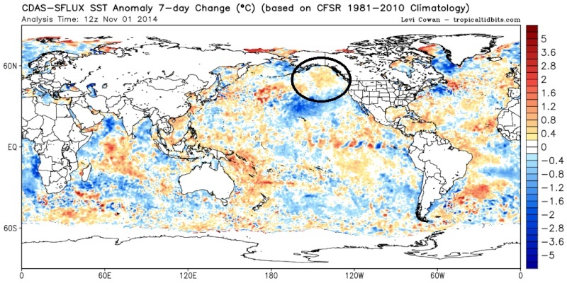
rb924119 wrote:I've been looking a little deeper at the progged pattern for next week and beyond, and we are going to be able to thank the typhoon currently off the coast of Japan. It's actually going to pump the central Pacific ridge up so much that the pattern over the Pacific wavebreaks and cuts that ridge off above Alaska. It eventually meanders over the North Pole and helps to reverse the height gradient (-AO). It also helps to create a stationary Gulf of Alaska trough which then induces a ridge over western North America (+PNA). The combination allows negative 500 hPa anomalies to flood the eastern half of the U.S. It is unclear at this time whether or not the expected Phase 1 MJO will help or hurt this pattern at this time, seeing as though tropical cyclone development could drastically alter our sensible weather. Just my two cents....
Awesome analysis and I agree. One thing I would like to see happening this season is some high latitude blocking at the NAO region. That would really help jump start the winter season.
_________________
_______________________________________________________________________________________________________
CLICK HERE to view NJ Strong Snowstorm Classifications

Frank_Wx- Godzilla Seeker
- Posts : 21305
Reputation : 328
Join date : 2013-01-05
Age : 31
Location : Jersey City, NJ -

Re: Official Long Range Thread 4.0
![]() by jmanley32 Sat Nov 01, 2014 6:32 pm
by jmanley32 Sat Nov 01, 2014 6:32 pm
jmanley32- Senior Enthusiast
- Posts : 20516
Reputation : 108
Join date : 2013-12-12
Age : 42
Location : Yonkers, NY
Re: Official Long Range Thread 4.0
![]() by rb924119 Sat Nov 01, 2014 7:08 pm
by rb924119 Sat Nov 01, 2014 7:08 pm
rb924119- Meteorologist
- Posts : 6890
Reputation : 194
Join date : 2013-02-06
Age : 32
Location : Greentown, Pa
Re: Official Long Range Thread 4.0
![]() by jmanley32 Sat Nov 01, 2014 7:46 pm
by jmanley32 Sat Nov 01, 2014 7:46 pm
jmanley32- Senior Enthusiast
- Posts : 20516
Reputation : 108
Join date : 2013-12-12
Age : 42
Location : Yonkers, NY
Re: Official Long Range Thread 4.0
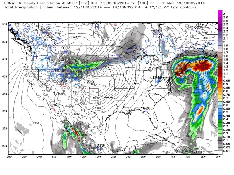
![]() by sroc4 Sat Nov 01, 2014 8:18 pm
by sroc4 Sat Nov 01, 2014 8:18 pm

[img]
 [/img]
_________________
"In weather and in life, there's no winning and losing; there's only winning and learning."
WINTER 2012/2013 TOTALS 43.65"WINTER 2017/2018 TOTALS 62.85" WINTER 2022/2023 TOTALS 4.9"
WINTER 2013/2014 TOTALS 64.85"WINTER 2018/2019 TOTALS 14.25" WINTER 2023/2024 TOTALS 13.1"
WINTER 2014/2015 TOTALS 71.20"WINTER 2019/2020 TOTALS 6.35"
WINTER 2015/2016 TOTALS 35.00"WINTER 2020/2021 TOTALS 37.75"
WINTER 2016/2017 TOTALS 42.25"WINTER 2021/2022 TOTALS 31.65"
sroc4- Admin
- Posts : 8331
Reputation : 301
Join date : 2013-01-07
Location : Wading River, LI
Re: Official Long Range Thread 4.0
![]() by amugs Sat Nov 01, 2014 11:09 pm
by amugs Sat Nov 01, 2014 11:09 pm
We will be doing A LOT of tracking these next few months IMHO.
Balls to the wall!
_________________
Mugs
AKA:King: Snow Weenie
Self Proclaimed
WINTER 2014-15 : 55.12" +.02 for 6 coatings (avg. 35")
WINTER 2015-16 Total - 29.8" (Avg 35")
WINTER 2016-17 : 39.5" so far

amugs- Advanced Forecaster - Mod

- Posts : 15093
Reputation : 213
Join date : 2013-01-07
Age : 54
Location : Hillsdale,NJ
Re: Official Long Range Thread 4.0
![]() by Frank_Wx Sun Nov 02, 2014 10:06 am
by Frank_Wx Sun Nov 02, 2014 10:06 am

_________________
_______________________________________________________________________________________________________
CLICK HERE to view NJ Strong Snowstorm Classifications
Frank_Wx- Godzilla Seeker
- Posts : 21305
Reputation : 328
Join date : 2013-01-05
Age : 31
Location : Jersey City, NJ -
Re: Official Long Range Thread 4.0
![]() by amugs Sun Nov 02, 2014 10:30 am
by amugs Sun Nov 02, 2014 10:30 am
Frank_Wx wrote:May have to change my November Outlook. A lot of changes these last two days. Signals beginning to kiss each other.
The times are a changing in more ways than one!!!!!!!!!!!!!!!!!
As I said in the other thread and posts - I like the long range and IT"S COMING!!!!!!!!!!!!!!!!!!!!
_________________
Mugs
AKA:King: Snow Weenie
Self Proclaimed
WINTER 2014-15 : 55.12" +.02 for 6 coatings (avg. 35")
WINTER 2015-16 Total - 29.8" (Avg 35")
WINTER 2016-17 : 39.5" so far
amugs- Advanced Forecaster - Mod
- Posts : 15093
Reputation : 213
Join date : 2013-01-07
Age : 54
Location : Hillsdale,NJ
Re: Official Long Range Thread 4.0
![]() by sroc4 Sun Nov 02, 2014 11:13 am
by sroc4 Sun Nov 02, 2014 11:13 am
Frank_Wx wrote:May have to change my November Outlook. A lot of changes these last two days. Signals beginning to kiss each other.
Looking more like an all out orgy..lol
_________________
"In weather and in life, there's no winning and losing; there's only winning and learning."
WINTER 2012/2013 TOTALS 43.65"WINTER 2017/2018 TOTALS 62.85" WINTER 2022/2023 TOTALS 4.9"
WINTER 2013/2014 TOTALS 64.85"WINTER 2018/2019 TOTALS 14.25" WINTER 2023/2024 TOTALS 13.1"
WINTER 2014/2015 TOTALS 71.20"WINTER 2019/2020 TOTALS 6.35"
WINTER 2015/2016 TOTALS 35.00"WINTER 2020/2021 TOTALS 37.75"
WINTER 2016/2017 TOTALS 42.25"WINTER 2021/2022 TOTALS 31.65"
sroc4- Admin
- Posts : 8331
Reputation : 301
Join date : 2013-01-07
Location : Wading River, LI
Re: Official Long Range Thread 4.0
![]() by jmanley32 Sun Nov 02, 2014 11:16 am
by jmanley32 Sun Nov 02, 2014 11:16 am
jmanley32- Senior Enthusiast
- Posts : 20516
Reputation : 108
Join date : 2013-12-12
Age : 42
Location : Yonkers, NY
Re: Official Long Range Thread 4.0
![]() by sroc4 Sun Nov 02, 2014 11:20 am
by sroc4 Sun Nov 02, 2014 11:20 am
_________________
"In weather and in life, there's no winning and losing; there's only winning and learning."
WINTER 2012/2013 TOTALS 43.65"WINTER 2017/2018 TOTALS 62.85" WINTER 2022/2023 TOTALS 4.9"
WINTER 2013/2014 TOTALS 64.85"WINTER 2018/2019 TOTALS 14.25" WINTER 2023/2024 TOTALS 13.1"
WINTER 2014/2015 TOTALS 71.20"WINTER 2019/2020 TOTALS 6.35"
WINTER 2015/2016 TOTALS 35.00"WINTER 2020/2021 TOTALS 37.75"
WINTER 2016/2017 TOTALS 42.25"WINTER 2021/2022 TOTALS 31.65"
sroc4- Admin
- Posts : 8331
Reputation : 301
Join date : 2013-01-07
Location : Wading River, LI
Re: Official Long Range Thread 4.0
![]() by skinsfan1177 Sun Nov 02, 2014 12:04 pm
by skinsfan1177 Sun Nov 02, 2014 12:04 pm

skinsfan1177- Senior Enthusiast
- Posts : 4485
Reputation : 35
Join date : 2013-01-07
Age : 46
Location : Point Pleasant Boro
Re: Official Long Range Thread 4.0
![]() by jmanley32 Sun Nov 02, 2014 1:44 pm
by jmanley32 Sun Nov 02, 2014 1:44 pm
jmanley32- Senior Enthusiast
- Posts : 20516
Reputation : 108
Join date : 2013-12-12
Age : 42
Location : Yonkers, NY
Re: Official Long Range Thread 4.0
![]() by jmanley32 Sun Nov 02, 2014 5:39 pm
by jmanley32 Sun Nov 02, 2014 5:39 pm
jmanley32- Senior Enthusiast
- Posts : 20516
Reputation : 108
Join date : 2013-12-12
Age : 42
Location : Yonkers, NY
Re: Official Long Range Thread 4.0
![]() by jmanley32 Sun Nov 02, 2014 7:39 pm
by jmanley32 Sun Nov 02, 2014 7:39 pm
jmanley32- Senior Enthusiast
- Posts : 20516
Reputation : 108
Join date : 2013-12-12
Age : 42
Location : Yonkers, NY
Re: Official Long Range Thread 4.0
![]() by jmanley32 Sun Nov 02, 2014 7:42 pm
by jmanley32 Sun Nov 02, 2014 7:42 pm

jmanley32- Senior Enthusiast
- Posts : 20516
Reputation : 108
Join date : 2013-12-12
Age : 42
Location : Yonkers, NY
Re: Official Long Range Thread 4.0
![]() by Sunflowers138 Sun Nov 02, 2014 9:02 pm
by Sunflowers138 Sun Nov 02, 2014 9:02 pm
Sunflowers138- Posts : 76
Reputation : 0
Join date : 2013-01-14
Re: Official Long Range Thread 4.0
![]() by jmanley32 Sun Nov 02, 2014 9:05 pm
by jmanley32 Sun Nov 02, 2014 9:05 pm
jmanley32- Senior Enthusiast
- Posts : 20516
Reputation : 108
Join date : 2013-12-12
Age : 42
Location : Yonkers, NY
Re: Official Long Range Thread 4.0
![]() by Sunflowers138 Sun Nov 02, 2014 9:14 pm
by Sunflowers138 Sun Nov 02, 2014 9:14 pm
Thanks for the reply!
Sunflowers138- Posts : 76
Reputation : 0
Join date : 2013-01-14
Re: Official Long Range Thread 4.0
![]() by amugs Sun Nov 02, 2014 9:20 pm
by amugs Sun Nov 02, 2014 9:20 pm
Instead of a warm November 1-15 and average to maybe slightly below November 16-30 like originally thought, it may be something like a slightly above to average November 1-7, but pretty cold for much of the month after that.
I think we see our fair share of coastal s and a good shot at snow in this pattern from mid month to the end accumulating maybe but a bk end squall is more likely - I think we start to see the stj come into play as well. Just one man's thoughts on this exciting pattern change.
I the using his iPad auto or react posting maps etc do not like it. Beggars can't be choosers right?
_________________
Mugs
AKA:King: Snow Weenie
Self Proclaimed
WINTER 2014-15 : 55.12" +.02 for 6 coatings (avg. 35")
WINTER 2015-16 Total - 29.8" (Avg 35")
WINTER 2016-17 : 39.5" so far
amugs- Advanced Forecaster - Mod
- Posts : 15093
Reputation : 213
Join date : 2013-01-07
Age : 54
Location : Hillsdale,NJ
Re: Official Long Range Thread 4.0
![]() by jmanley32 Sun Nov 02, 2014 9:23 pm
by jmanley32 Sun Nov 02, 2014 9:23 pm
jmanley32- Senior Enthusiast
- Posts : 20516
Reputation : 108
Join date : 2013-12-12
Age : 42
Location : Yonkers, NY
Page 2 of 42 • 1, 2, 3 ... 22 ... 42 ![]()
|
|
|