
 Search
Sunday-Monday Snowstorm - 2nd Call Snow Map
Page 7 of 8 •  1, 2, 3, 4, 5, 6, 7, 8
 ![]()
Re: Sunday-Monday Snowstorm - 2nd Call Snow Map
![]() by aiannone Sat Feb 28, 2015 10:52 pm
by aiannone Sat Feb 28, 2015 10:52 pm
aiannone- Senior Enthusiast - Mod

- Posts : 4813
Join date : 2013-01-07
Re: Sunday-Monday Snowstorm - 2nd Call Snow Map
![]() by amugs Sat Feb 28, 2015 10:54 pm
by amugs Sat Feb 28, 2015 10:54 pm

amugs- Advanced Forecaster - Mod
- Posts : 15093
Join date : 2013-01-07
Re: Sunday-Monday Snowstorm - 2nd Call Snow Map
![]() by jimv45 Sat Feb 28, 2015 11:05 pm
by jimv45 Sat Feb 28, 2015 11:05 pm
jimv45- Senior Enthusiast

- Posts : 1168
Reputation : 36
Join date : 2013-09-20
Location : Hopewell jct.
Re: Sunday-Monday Snowstorm - 2nd Call Snow Map
![]() by Math23x7 Sat Feb 28, 2015 11:09 pm
by Math23x7 Sat Feb 28, 2015 11:09 pm
Math23x7- Wx Statistician Guru

- Posts : 2379
Reputation : 68
Join date : 2013-01-08
Re: Sunday-Monday Snowstorm - 2nd Call Snow Map
![]() by rb924119 Sat Feb 28, 2015 11:09 pm
by rb924119 Sat Feb 28, 2015 11:09 pm


The first one is basically referring to vorticity and advection of vorticity. There are two types: Negative and positive. The negative vorticity is created in ridges, and in areas of horizontal wind shear on the anti-cyclonic side of a jet. This energy can be thought of as energy in the mid- and upper-levels that contains the same properties as surface high-pressure systems (fair weather, sinking motion, clockwise rotation). Assuming (ideally) that this energy exists only in the crests of large-scale ridges (although this is not entirely true, it is a fair enough assumption to demonstrate) then as the wind blows through this energy, it actually takes those properties with it as it continues downstream. Similarly, the positive energy can be assumed to be created in the bases of large-scale troughs as well as in horizontal wind shear on the cyclonic side of a jet. Thinking of this energy as having similar properties to surface low-pressure systems (counter-clockwise rotation, inclement weather, ascent), as the wind blows through it those properties are also carried downstream. The first image relates these ideas to the jet structure from earlier.
The second image relates these concepts to the overall trough-ridge pattern. Between the ageostrophic circulation that I discussed earlier (remember, it decreases to zero at the maximum distance away from a jet-streak, "blows" against the normal wind entering jet-streaks and with the normal wind leaving jet-streaks) and now these most recent concepts, this is what actually works to cause surface high and low pressure systems. For example, if you look at any set of 300/500mb maps of jets and/or vorticity (the energy created in the most recent concepts) and then of the surface, you WILL ALWAYS find that surface high-pressures are located directly beneath these two combined negative forcings, which ends up being directly at the inflection point between a ridge and a trough. On the contrary, surface low-pressure systems are always found where these two types of positive forcings are located, which is ALWAYS at the inflection point between a trough and ridge.
Last edited by rb924119 on Sat Feb 28, 2015 11:11 pm; edited 1 time in total
rb924119- Meteorologist

- Posts : 6890
Reputation : 194
Join date : 2013-02-06
Age : 32
Location : Greentown, Pa
Re: Sunday-Monday Snowstorm - 2nd Call Snow Map
![]() by Math23x7 Sat Feb 28, 2015 11:10 pm
by Math23x7 Sat Feb 28, 2015 11:10 pm
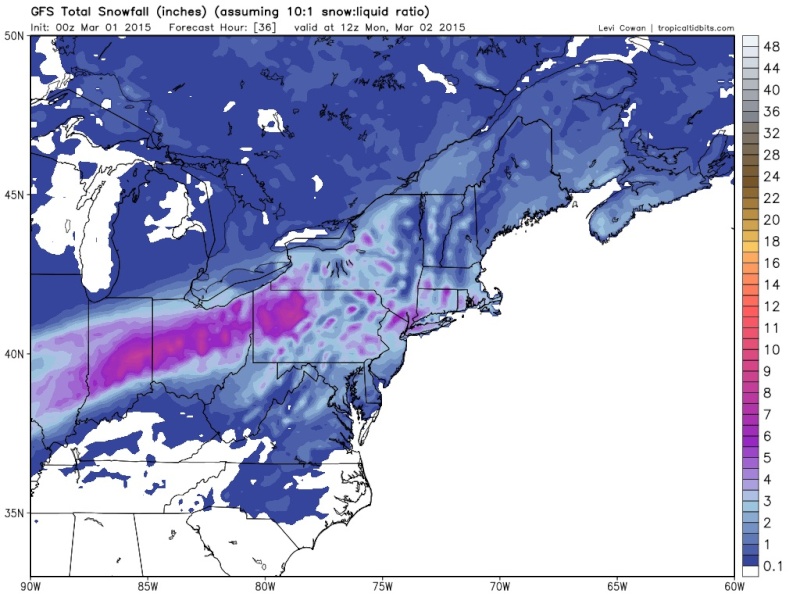
Math23x7 wrote:0Z GFS shows much less snow for NYC/LI. Snow-ice for the Lower Hudson Valley.
Wait, I was looking at precip type, but the snow totals still says ~4 inches for NYC.
Math23x7- Wx Statistician Guru
- Posts : 2379
Reputation : 68
Join date : 2013-01-08
Re: Sunday-Monday Snowstorm - 2nd Call Snow Map
![]() by snow247 Sat Feb 28, 2015 11:12 pm
by snow247 Sat Feb 28, 2015 11:12 pm

snow247- Pro Enthusiast

- Posts : 2417
Reputation : 0
Join date : 2014-08-27
Location : Mount Ivy, NY - Elevation 545'
Re: Sunday-Monday Snowstorm - 2nd Call Snow Map
![]() by aiannone Sat Feb 28, 2015 11:13 pm
by aiannone Sat Feb 28, 2015 11:13 pm
snow247 wrote:00z GFS, almost jackpots me lol, cool how the GFS notices the 1000'+ mountains just a mile or two to the NW of me and gives them more snow.
That looks colder for LI/NYC not less snow
_________________
-Alex Iannone-

aiannone- Senior Enthusiast - Mod
- Posts : 4813
Reputation : 92
Join date : 2013-01-07
Location : Saint James, LI (Northwest Suffolk Co.)
Re: Sunday-Monday Snowstorm - 2nd Call Snow Map
![]() by amugs Sat Feb 28, 2015 11:16 pm
by amugs Sat Feb 28, 2015 11:16 pm
_________________
Mugs
AKA:King: Snow Weenie
Self Proclaimed
WINTER 2014-15 : 55.12" +.02 for 6 coatings (avg. 35")
WINTER 2015-16 Total - 29.8" (Avg 35")
WINTER 2016-17 : 39.5" so far

amugs- Advanced Forecaster - Mod
- Posts : 15093
Reputation : 213
Join date : 2013-01-07
Age : 54
Location : Hillsdale,NJ
Re: Sunday-Monday Snowstorm - 2nd Call Snow Map
![]() by aiannone Sat Feb 28, 2015 11:17 pm
by aiannone Sat Feb 28, 2015 11:17 pm
_________________
-Alex Iannone-
aiannone- Senior Enthusiast - Mod
- Posts : 4813
Reputation : 92
Join date : 2013-01-07
Location : Saint James, LI (Northwest Suffolk Co.)
Re: Sunday-Monday Snowstorm - 2nd Call Snow Map
![]() by amugs Sat Feb 28, 2015 11:18 pm
by amugs Sat Feb 28, 2015 11:18 pm
_________________
Mugs
AKA:King: Snow Weenie
Self Proclaimed
WINTER 2014-15 : 55.12" +.02 for 6 coatings (avg. 35")
WINTER 2015-16 Total - 29.8" (Avg 35")
WINTER 2016-17 : 39.5" so far
amugs- Advanced Forecaster - Mod
- Posts : 15093
Reputation : 213
Join date : 2013-01-07
Age : 54
Location : Hillsdale,NJ
Re: Sunday-Monday Snowstorm - 2nd Call Snow Map
![]() by amugs Sat Feb 28, 2015 11:22 pm
by amugs Sat Feb 28, 2015 11:22 pm
_________________
Mugs
AKA:King: Snow Weenie
Self Proclaimed
WINTER 2014-15 : 55.12" +.02 for 6 coatings (avg. 35")
WINTER 2015-16 Total - 29.8" (Avg 35")
WINTER 2016-17 : 39.5" so far
amugs- Advanced Forecaster - Mod
- Posts : 15093
Reputation : 213
Join date : 2013-01-07
Age : 54
Location : Hillsdale,NJ
Re: Sunday-Monday Snowstorm - 2nd Call Snow Map
![]() by aiannone Sat Feb 28, 2015 11:22 pm
by aiannone Sat Feb 28, 2015 11:22 pm
_________________
-Alex Iannone-
aiannone- Senior Enthusiast - Mod
- Posts : 4813
Reputation : 92
Join date : 2013-01-07
Location : Saint James, LI (Northwest Suffolk Co.)
Re: Sunday-Monday Snowstorm - 2nd Call Snow Map
![]() by aiannone Sat Feb 28, 2015 11:25 pm
by aiannone Sat Feb 28, 2015 11:25 pm
_________________
-Alex Iannone-
aiannone- Senior Enthusiast - Mod
- Posts : 4813
Reputation : 92
Join date : 2013-01-07
Location : Saint James, LI (Northwest Suffolk Co.)
Re: Sunday-Monday Snowstorm - 2nd Call Snow Map
![]() by amugs Sat Feb 28, 2015 11:26 pm
by amugs Sat Feb 28, 2015 11:26 pm
aiannone wrote:Jeff's future cast shows all snow now for NYC/LI. Yet still has 1-3"........
Alex I did not see hi forecast but I thought Jim said Smith said 3-6"?? If not then I a, calling him out. What the f is he looking at?? This is what pisses me off everything showing a good snowstorm and they say no to it by giving a clipper type of accumulation, give me a break!
_________________
Mugs
AKA:King: Snow Weenie
Self Proclaimed
WINTER 2014-15 : 55.12" +.02 for 6 coatings (avg. 35")
WINTER 2015-16 Total - 29.8" (Avg 35")
WINTER 2016-17 : 39.5" so far
amugs- Advanced Forecaster - Mod
- Posts : 15093
Reputation : 213
Join date : 2013-01-07
Age : 54
Location : Hillsdale,NJ
Re: Sunday-Monday Snowstorm - 2nd Call Snow Map
![]() by jimv45 Sat Feb 28, 2015 11:29 pm
by jimv45 Sat Feb 28, 2015 11:29 pm
jimv45- Senior Enthusiast
- Posts : 1168
Reputation : 36
Join date : 2013-09-20
Location : Hopewell jct.
Re: Sunday-Monday Snowstorm - 2nd Call Snow Map
![]() by rb924119 Sat Feb 28, 2015 11:31 pm
by rb924119 Sat Feb 28, 2015 11:31 pm
amugs wrote:aiannone wrote:Jeff's future cast shows all snow now for NYC/LI. Yet still has 1-3"........
Alex I did not see hi forecast but I thought Jim said Smith said 3-6"?? If not then I a, calling him out. What the f is he looking at?? This is what pisses me off everything showing a good snowstorm and they say no to it by giving a clipper type of accumulation, give me a break!
Mugs, if might do so without aggravating you; I agree with them. I think the dynamics of this storm are going to end up being sub-par, which will result in lower totals than what we are actually seeing right now....just like the last event. I'm headed to bed now, and tomorrow will already be too late for an analysis/map, but I think a general 3-5" and at most 6" is all we'll see from this, with 1-3" south of central NJ. This is not a setup for a sizable event. Just my opinion, and I truly hope I'm wrong lmao
Last edited by rb924119 on Sat Feb 28, 2015 11:35 pm; edited 1 time in total
rb924119- Meteorologist
- Posts : 6890
Reputation : 194
Join date : 2013-02-06
Age : 32
Location : Greentown, Pa
Re: Sunday-Monday Snowstorm - 2nd Call Snow Map
![]() by aiannone Sat Feb 28, 2015 11:31 pm
by aiannone Sat Feb 28, 2015 11:31 pm
amugs wrote:aiannone wrote:Jeff's future cast shows all snow now for NYC/LI. Yet still has 1-3"........
Alex I did not see hi forecast but I thought Jim said Smith said 3-6"?? If not then I a, calling him out. What the f is he looking at?? This is what pisses me off everything showing a good snowstorm and they say no to it by giving a clipper type of accumulation, give me a break!
Well he brought the 3-6" down to the GW bridge. You are in 3-6" but NYC/LI is in 1-3"
_________________
-Alex Iannone-
aiannone- Senior Enthusiast - Mod
- Posts : 4813
Reputation : 92
Join date : 2013-01-07
Location : Saint James, LI (Northwest Suffolk Co.)
Re: Sunday-Monday Snowstorm - 2nd Call Snow Map
![]() by Math23x7 Sat Feb 28, 2015 11:32 pm
by Math23x7 Sat Feb 28, 2015 11:32 pm
amugs wrote:Math where do you see less snow on the gfs map posted??
I was looking at the precip type and for some reason it did not have that much snow or ice in NYC and LI. Yet, the snowmap had ~4" for NYC on weatherbell (not sure if it's an assumed 10:1 ratio).
Math23x7- Wx Statistician Guru
- Posts : 2379
Reputation : 68
Join date : 2013-01-08
Re: Sunday-Monday Snowstorm - 2nd Call Snow Map
![]() by Dunnzoo Sat Feb 28, 2015 11:32 pm
by Dunnzoo Sat Feb 28, 2015 11:32 pm
_________________
Janet
Snowfall winter of 2023-2024 17.5"
Snowfall winter of 2022-2023 6.0"
Snowfall winter of 2021-2022 17.6" 1" sleet 2/25/22
Snowfall winter of 2020-2021 51.1"
Snowfall winter of 2019-2020 8.5"
Snowfall winter of 2018-2019 25.1"
Snowfall winter of 2017-2018 51.9"
Snowfall winter of 2016-2017 45.6"
Snowfall winter of 2015-2016 29.5"
Snowfall winter of 2014-2015 50.55"
Snowfall winter of 2013-2014 66.5"

Dunnzoo- Senior Enthusiast - Mod
- Posts : 4891
Reputation : 68
Join date : 2013-01-11
Age : 62
Location : Westwood, NJ
Re: Sunday-Monday Snowstorm - 2nd Call Snow Map
![]() by Guest Sat Feb 28, 2015 11:32 pm
by Guest Sat Feb 28, 2015 11:32 pm
Guest- Guest
Re: Sunday-Monday Snowstorm - 2nd Call Snow Map
![]() by amugs Sat Feb 28, 2015 11:34 pm
by amugs Sat Feb 28, 2015 11:34 pm
rb924119 wrote:amugs wrote:aiannone wrote:Jeff's future cast shows all snow now for NYC/LI. Yet still has 1-3"........
Alex I did not see hi forecast but I thought Jim said Smith said 3-6"?? If not then I a, calling him out. What the f is he looking at?? This is what pisses me off everything showing a good snowstorm and they say no to it by giving a clipper type of accumulation, give me a break!
Mugs, if might do so without aggravating you; I agree with them. I think the dynamics of this storm are going to end up being sub-par, which will result in lower totals than what we are actually seeing right now....just like the last event. I'm headed to bed now, and tomorrow will already be too late for an analysis/map, but I think a general 3-5" and at most 6" is all we'll see from this. This is not a setup for a sizable event. Just my opinion, and I truly hope I'm wrong lmao
Rb 3-5" is not 1-3". So even with this they are setting up for failure, no??
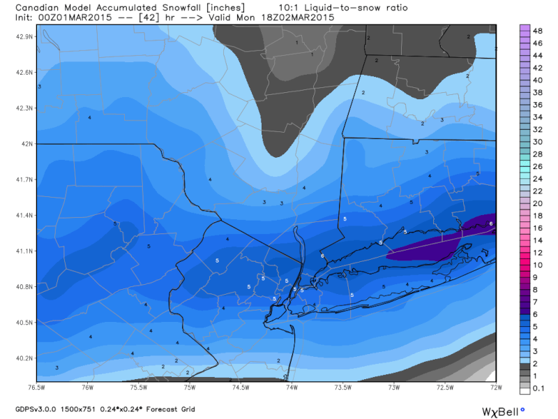
Btw cmc is colder and a tad wette.
_________________
Mugs
AKA:King: Snow Weenie
Self Proclaimed
WINTER 2014-15 : 55.12" +.02 for 6 coatings (avg. 35")
WINTER 2015-16 Total - 29.8" (Avg 35")
WINTER 2016-17 : 39.5" so far
amugs- Advanced Forecaster - Mod
- Posts : 15093
Reputation : 213
Join date : 2013-01-07
Age : 54
Location : Hillsdale,NJ
Re: Sunday-Monday Snowstorm - 2nd Call Snow Map
![]() by jimv45 Sat Feb 28, 2015 11:38 pm
by jimv45 Sat Feb 28, 2015 11:38 pm
jimv45- Senior Enthusiast
- Posts : 1168
Reputation : 36
Join date : 2013-09-20
Location : Hopewell jct.
Re: Sunday-Monday Snowstorm - 2nd Call Snow Map
![]() by aiannone Sat Feb 28, 2015 11:38 pm
by aiannone Sat Feb 28, 2015 11:38 pm
_________________
-Alex Iannone-
aiannone- Senior Enthusiast - Mod
- Posts : 4813
Reputation : 92
Join date : 2013-01-07
Location : Saint James, LI (Northwest Suffolk Co.)
Re: Sunday-Monday Snowstorm - 2nd Call Snow Map
![]() by rb924119 Sat Feb 28, 2015 11:39 pm
by rb924119 Sat Feb 28, 2015 11:39 pm
amugs wrote:rb924119 wrote:amugs wrote:aiannone wrote:Jeff's future cast shows all snow now for NYC/LI. Yet still has 1-3"........
Alex I did not see hi forecast but I thought Jim said Smith said 3-6"?? If not then I a, calling him out. What the f is he looking at?? This is what pisses me off everything showing a good snowstorm and they say no to it by giving a clipper type of accumulation, give me a break!
Mugs, if might do so without aggravating you; I agree with them. I think the dynamics of this storm are going to end up being sub-par, which will result in lower totals than what we are actually seeing right now....just like the last event. I'm headed to bed now, and tomorrow will already be too late for an analysis/map, but I think a general 3-5" and at most 6" is all we'll see from this. This is not a setup for a sizable event. Just my opinion, and I truly hope I'm wrong lmao
Rb 3-5" is not 1-3". So even with this they are setting up for failure, no??
Btw cmc is colder and a tad wette.
Yes. But my point is that I don't think we actually receive the numbers that are being forecast. That's all.
rb924119- Meteorologist
- Posts : 6890
Reputation : 194
Join date : 2013-02-06
Age : 32
Location : Greentown, Pa
Re: Sunday-Monday Snowstorm - 2nd Call Snow Map
![]() by rb924119 Sat Feb 28, 2015 11:40 pm
by rb924119 Sat Feb 28, 2015 11:40 pm
rb924119- Meteorologist
- Posts : 6890
Reputation : 194
Join date : 2013-02-06
Age : 32
Location : Greentown, Pa
Re: Sunday-Monday Snowstorm - 2nd Call Snow Map
![]() by hyde345 Sun Mar 01, 2015 12:04 am
by hyde345 Sun Mar 01, 2015 12:04 am
jimv45 wrote:Yes I agree rb hope for more but unlikely.
Jim, something tells me we are only going to see 3-4 inches with this one. NWS has us in 4-6 but I don't see it.

hyde345- Pro Enthusiast
- Posts : 1082
Reputation : 48
Join date : 2013-01-08
Location : Hyde Park, NY
Page 7 of 8 • 1, 2, 3, 4, 5, 6, 7, 8 ![]()
|
|
|