
 Search
Sunday-Monday Snowstorm - 2nd Call Snow Map
Page 3 of 8 •  1, 2, 3, 4, 5, 6, 7, 8
 ![]()
Re: Sunday-Monday Snowstorm - 2nd Call Snow Map
![]() by Frank_Wx Sat Feb 28, 2015 4:50 pm
by Frank_Wx Sat Feb 28, 2015 4:50 pm
lglickman1 wrote:Hoe long is this event supposed to be?
Figure 1pm until 5am.
Frank_Wx- Godzilla Seeker

- Posts : 21305
Join date : 2013-01-05 -

Re: Sunday-Monday Snowstorm - 2nd Call Snow Map
![]() by Frank_Wx Sat Feb 28, 2015 4:53 pm
by Frank_Wx Sat Feb 28, 2015 4:53 pm
Frank_Wx- Godzilla Seeker
- Posts : 21305
Join date : 2013-01-05 -
Re: Sunday-Monday Snowstorm - 2nd Call Snow Map
![]() by nutleyblizzard Sat Feb 28, 2015 4:57 pm
by nutleyblizzard Sat Feb 28, 2015 4:57 pm

nutleyblizzard- Senior Enthusiast

- Posts : 1952
Reputation : 41
Join date : 2014-01-30
Age : 58
Location : Nutley, new jersey
Re: Sunday-Monday Snowstorm - 2nd Call Snow Map
![]() by snow247 Sat Feb 28, 2015 4:59 pm
by snow247 Sat Feb 28, 2015 4:59 pm

snow247- Pro Enthusiast

- Posts : 2417
Reputation : 0
Join date : 2014-08-27
Location : Mount Ivy, NY - Elevation 545'
Re: Sunday-Monday Snowstorm - 2nd Call Snow Map
![]() by Frank_Wx Sat Feb 28, 2015 5:01 pm
by Frank_Wx Sat Feb 28, 2015 5:01 pm

_________________
_______________________________________________________________________________________________________
CLICK HERE to view NJ Strong Snowstorm Classifications

Frank_Wx- Godzilla Seeker
- Posts : 21305
Reputation : 328
Join date : 2013-01-05
Age : 31
Location : Jersey City, NJ -
Re: Sunday-Monday Snowstorm - 2nd Call Snow Map
![]() by RJB8525 Sat Feb 28, 2015 5:03 pm
by RJB8525 Sat Feb 28, 2015 5:03 pm
hopefully not much ice will get in

RJB8525- Senior Enthusiast
- Posts : 1994
Reputation : 28
Join date : 2013-02-06
Age : 38
Location : Hackettstown, NJ
Re: Sunday-Monday Snowstorm - 2nd Call Snow Map
![]() by aiannone Sat Feb 28, 2015 5:04 pm
by aiannone Sat Feb 28, 2015 5:04 pm
_________________
-Alex Iannone-

aiannone- Senior Enthusiast - Mod

- Posts : 4813
Reputation : 92
Join date : 2013-01-07
Location : Saint James, LI (Northwest Suffolk Co.)
Re: Sunday-Monday Snowstorm - 2nd Call Snow Map
![]() by snow247 Sat Feb 28, 2015 5:04 pm
by snow247 Sat Feb 28, 2015 5:04 pm
Frank, would you mind putting my map in the first post or something so it doesn't get buried in the thread? Thanks.

snow247- Pro Enthusiast
- Posts : 2417
Reputation : 0
Join date : 2014-08-27
Location : Mount Ivy, NY - Elevation 545'
Re: Sunday-Monday Snowstorm - 2nd Call Snow Map
![]() by jimv45 Sat Feb 28, 2015 5:06 pm
by jimv45 Sat Feb 28, 2015 5:06 pm
jimv45- Senior Enthusiast
- Posts : 1168
Reputation : 36
Join date : 2013-09-20
Location : Hopewell jct.
Re: Sunday-Monday Snowstorm - 2nd Call Snow Map
![]() by Frank_Wx Sat Feb 28, 2015 5:07 pm
by Frank_Wx Sat Feb 28, 2015 5:07 pm
snow247 wrote:Second call, though if the usual south trend continues I'll have to move the heavier area further south, especially on LI, again.
Frank, would you mind putting my map in the first post or something so it doesn't get buried in the thread? Thanks.
Create a maps only thread and I'll pin it
_________________
_______________________________________________________________________________________________________
CLICK HERE to view NJ Strong Snowstorm Classifications
Frank_Wx- Godzilla Seeker
- Posts : 21305
Reputation : 328
Join date : 2013-01-05
Age : 31
Location : Jersey City, NJ -
Re: Sunday-Monday Snowstorm - 2nd Call Snow Map
![]() by aiannone Sat Feb 28, 2015 5:09 pm
by aiannone Sat Feb 28, 2015 5:09 pm
_________________
-Alex Iannone-
aiannone- Senior Enthusiast - Mod
- Posts : 4813
Reputation : 92
Join date : 2013-01-07
Location : Saint James, LI (Northwest Suffolk Co.)
Re: Sunday-Monday Snowstorm - 2nd Call Snow Map
![]() by snow247 Sat Feb 28, 2015 5:10 pm
by snow247 Sat Feb 28, 2015 5:10 pm
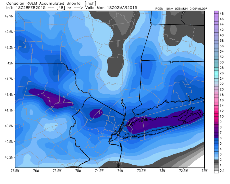
aiannone wrote:18z RGEM Close-up
What's with the screw zone in the mid-upper HV?
snow247- Pro Enthusiast
- Posts : 2417
Reputation : 0
Join date : 2014-08-27
Location : Mount Ivy, NY - Elevation 545'
Re: Sunday-Monday Snowstorm - 2nd Call Snow Map
![]() by rb924119 Sat Feb 28, 2015 5:20 pm
by rb924119 Sat Feb 28, 2015 5:20 pm
rb924119- Meteorologist

- Posts : 6890
Reputation : 194
Join date : 2013-02-06
Age : 32
Location : Greentown, Pa
Re: Sunday-Monday Snowstorm - 2nd Call Snow Map
![]() by rb924119 Sat Feb 28, 2015 5:24 pm
by rb924119 Sat Feb 28, 2015 5:24 pm
rb924119- Meteorologist
- Posts : 6890
Reputation : 194
Join date : 2013-02-06
Age : 32
Location : Greentown, Pa
Re: Sunday-Monday Snowstorm - 2nd Call Snow Map
![]() by snow247 Sat Feb 28, 2015 5:24 pm
by snow247 Sat Feb 28, 2015 5:24 pm
Should I go?
snow247- Pro Enthusiast
- Posts : 2417
Reputation : 0
Join date : 2014-08-27
Location : Mount Ivy, NY - Elevation 545'
Re: Sunday-Monday Snowstorm - 2nd Call Snow Map
![]() by Frank_Wx Sat Feb 28, 2015 5:29 pm
by Frank_Wx Sat Feb 28, 2015 5:29 pm
_________________
_______________________________________________________________________________________________________
CLICK HERE to view NJ Strong Snowstorm Classifications
Frank_Wx- Godzilla Seeker
- Posts : 21305
Reputation : 328
Join date : 2013-01-05
Age : 31
Location : Jersey City, NJ -
Re: Sunday-Monday Snowstorm - 2nd Call Snow Map
![]() by Frank_Wx Sat Feb 28, 2015 5:31 pm
by Frank_Wx Sat Feb 28, 2015 5:31 pm
rb924119 wrote:Hmmmm anybody notice the quasi-northwest to southeast orientation of the swath of heaviest snows? I have a hunch that this is picking up on a HIGHLY MESO-SCALE band that may be induced by (extremely low-level) 925-850 hPa frontogenesis. My reasoning for this is that this is SWFE, so that fits the general orientation of the thermal profile as well as the wind profile (winds crossing the east-west tightening thermal gradient from southwest to northeast). Can anybody get 925/850 temperature and wind maps to possibly confirm?


_________________
_______________________________________________________________________________________________________
CLICK HERE to view NJ Strong Snowstorm Classifications
Frank_Wx- Godzilla Seeker
- Posts : 21305
Reputation : 328
Join date : 2013-01-05
Age : 31
Location : Jersey City, NJ -
Re: Sunday-Monday Snowstorm - 2nd Call Snow Map
![]() by snow247 Sat Feb 28, 2015 5:33 pm
by snow247 Sat Feb 28, 2015 5:33 pm
Frank_Wx wrote:You can go but be prepared to drive in snow. Heaviest though won't be till later in the afternoon.
Thanks
snow247- Pro Enthusiast
- Posts : 2417
Reputation : 0
Join date : 2014-08-27
Location : Mount Ivy, NY - Elevation 545'
Re: Sunday-Monday Snowstorm - 2nd Call Snow Map
![]() by rb924119 Sat Feb 28, 2015 5:37 pm
by rb924119 Sat Feb 28, 2015 5:37 pm
Frank_Wx wrote:rb924119 wrote:Hmmmm anybody notice the quasi-northwest to southeast orientation of the swath of heaviest snows? I have a hunch that this is picking up on a HIGHLY MESO-SCALE band that may be induced by (extremely low-level) 925-850 hPa frontogenesis. My reasoning for this is that this is SWFE, so that fits the general orientation of the thermal profile as well as the wind profile (winds crossing the east-west tightening thermal gradient from southwest to northeast). Can anybody get 925/850 temperature and wind maps to possibly confirm?
Well then never mind about that lol There clearly has to be something forcing that....
rb924119- Meteorologist
- Posts : 6890
Reputation : 194
Join date : 2013-02-06
Age : 32
Location : Greentown, Pa
Re: Sunday-Monday Snowstorm - 2nd Call Snow Map
![]() by Frank_Wx Sat Feb 28, 2015 5:40 pm
by Frank_Wx Sat Feb 28, 2015 5:40 pm
_________________
_______________________________________________________________________________________________________
CLICK HERE to view NJ Strong Snowstorm Classifications
Frank_Wx- Godzilla Seeker
- Posts : 21305
Reputation : 328
Join date : 2013-01-05
Age : 31
Location : Jersey City, NJ -
Re: Sunday-Monday Snowstorm - 2nd Call Snow Map
![]() by rb924119 Sat Feb 28, 2015 5:42 pm
by rb924119 Sat Feb 28, 2015 5:42 pm
Frank_Wx wrote:I just think this is a classic event with a strong upper level jet streak wedged between the PV and SE Ridge. That's where all your forcing is coming from.
But we aren't located in favorable spots for that to aid us; in fact, it's kind of the opposite or a non-factor completely.
rb924119- Meteorologist
- Posts : 6890
Reputation : 194
Join date : 2013-02-06
Age : 32
Location : Greentown, Pa
Re: Sunday-Monday Snowstorm - 2nd Call Snow Map
![]() by rb924119 Sat Feb 28, 2015 5:43 pm
by rb924119 Sat Feb 28, 2015 5:43 pm
rb924119- Meteorologist
- Posts : 6890
Reputation : 194
Join date : 2013-02-06
Age : 32
Location : Greentown, Pa
Re: Sunday-Monday Snowstorm - 2nd Call Snow Map
![]() by Frank_Wx Sat Feb 28, 2015 5:44 pm
by Frank_Wx Sat Feb 28, 2015 5:44 pm
rb924119 wrote:Frank_Wx wrote:I just think this is a classic event with a strong upper level jet streak wedged between the PV and SE Ridge. That's where all your forcing is coming from.
But we aren't located in favorable spots for that to aid us; in fact, it's kind of the opposite or a non-factor completely.
Yes...ideally we want it south of us? Either way, the intense thermal gradients should help bring about frontogenesis.
_________________
_______________________________________________________________________________________________________
CLICK HERE to view NJ Strong Snowstorm Classifications
Frank_Wx- Godzilla Seeker
- Posts : 21305
Reputation : 328
Join date : 2013-01-05
Age : 31
Location : Jersey City, NJ -
Re: Sunday-Monday Snowstorm - 2nd Call Snow Map
![]() by Frank_Wx Sat Feb 28, 2015 5:53 pm
by Frank_Wx Sat Feb 28, 2015 5:53 pm

_________________
_______________________________________________________________________________________________________
CLICK HERE to view NJ Strong Snowstorm Classifications
Frank_Wx- Godzilla Seeker
- Posts : 21305
Reputation : 328
Join date : 2013-01-05
Age : 31
Location : Jersey City, NJ -
Re: Sunday-Monday Snowstorm - 2nd Call Snow Map
![]() by oldtimer Sat Feb 28, 2015 5:57 pm
by oldtimer Sat Feb 28, 2015 5:57 pm
oldtimer- Senior Enthusiast
- Posts : 1103
Reputation : 14
Join date : 2013-01-16
Age : 78
Location : Port Jefferson Station Suffolk County
Re: Sunday-Monday Snowstorm - 2nd Call Snow Map
![]() by RJB8525 Sat Feb 28, 2015 6:04 pm
by RJB8525 Sat Feb 28, 2015 6:04 pm
RJB8525- Senior Enthusiast
- Posts : 1994
Reputation : 28
Join date : 2013-02-06
Age : 38
Location : Hackettstown, NJ
Re: Sunday-Monday Snowstorm - 2nd Call Snow Map
![]() by rb924119 Sat Feb 28, 2015 6:12 pm
by rb924119 Sat Feb 28, 2015 6:12 pm
Frank_Wx wrote:rb924119 wrote:Frank_Wx wrote:I just think this is a classic event with a strong upper level jet streak wedged between the PV and SE Ridge. That's where all your forcing is coming from.
But we aren't located in favorable spots for that to aid us; in fact, it's kind of the opposite or a non-factor completely.
Yes...ideally we want it south of us? Either way, the intense thermal gradients should help bring about frontogenesis.
Yeah. In the H2 image you posted, there would be three ideal locations and orientations. In the orientation that it is in on your image, we'd ideally want it located over extreme southern Ohio, Indiana and Illinois. Our second option, would be to have it oriented southwest-northeast from approximately 200 miles east of the Delmarva and stretching back to the south-southwest. Our third, and most likely only viable option if we had a coupled jet system with a second jet located where I just mentioned to stave off p-type issues) would to have it located in any orientation from around or just north of the eastern Great Lakes and stretching eastward from there.
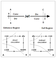
Take a look at the following images and see if you can figure it out. I don't mean to sound rude, but I have to go for a while. I'll be back to further explain in a little bit. This is the ageostrophic circulation that I was talking about in the case study. and why you tend to see rising/sinking motion associated with different locations in jets.
Idealized jet structure:
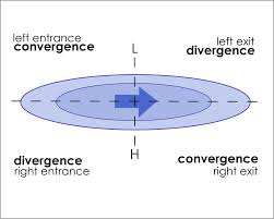
Cross-sections representing vertical motion associated with jets. The shorter and stronger the jet streak, the stronger the vertical circulations are (because of the dynamics, which I can explain later if you'd like; let me know):
rb924119- Meteorologist
- Posts : 6890
Reputation : 194
Join date : 2013-02-06
Age : 32
Location : Greentown, Pa
Page 3 of 8 • 1, 2, 3, 4, 5, 6, 7, 8 ![]()
|
|
|