
 Search
Long Range Thread 8.0
Page 16 of 40 •  1 ... 9 ... 15, 16, 17 ... 28 ... 40
 ![]()
Re: Long Range Thread 8.0
![]() by amugs Sat Oct 03, 2015 2:46 pm
by amugs Sat Oct 03, 2015 2:46 pm
Frank_Wx wrote:I see what you mean. But if the core of the warm SST anomalies concentrate south of the Aleutians, that may lead to ridging over that area instead of a trough. We'll see how SSTs look by months end.
Expect 70s to return next week, but as Mugs' map show, we'll be entering a pattern change next weekend to cooler weather.
I agree and at this point I will take this
amugs- Advanced Forecaster - Mod

- Posts : 15093
Join date : 2013-01-07
Re: Long Range Thread 8.0
![]() by jmanley32 Sat Oct 03, 2015 3:54 pm
by jmanley32 Sat Oct 03, 2015 3:54 pm
jmanley32- Senior Enthusiast

- Posts : 20513
Join date : 2013-12-12
Re: Long Range Thread 8.0
![]() by jmanley32 Sat Oct 03, 2015 3:57 pm
by jmanley32 Sat Oct 03, 2015 3:57 pm

jmanley32- Senior Enthusiast
- Posts : 20513
Reputation : 108
Join date : 2013-12-12
Age : 42
Location : Yonkers, NY
Re: Long Range Thread 8.0
![]() by amugs Sat Oct 03, 2015 5:19 pm
by amugs Sat Oct 03, 2015 5:19 pm


Latest daily SOI value is -49.70 compared to this 1997 was -85.72[/b] So those who are wishing for that type of winter - we are far away. Models all showing that Nino peaks late Nov early Dec.
The pattern right now is great only wish it was winter!!
_________________
Mugs
AKA:King: Snow Weenie
Self Proclaimed
WINTER 2014-15 : 55.12" +.02 for 6 coatings (avg. 35")
WINTER 2015-16 Total - 29.8" (Avg 35")
WINTER 2016-17 : 39.5" so far

amugs- Advanced Forecaster - Mod
- Posts : 15093
Reputation : 213
Join date : 2013-01-07
Age : 54
Location : Hillsdale,NJ
Re: Long Range Thread 8.0
![]() by devsman Sat Oct 03, 2015 10:26 pm
by devsman Sat Oct 03, 2015 10:26 pm

devsman- Pro Enthusiast

- Posts : 424
Reputation : 4
Join date : 2014-01-01
Age : 48
Location : merrick, ny (south shore of Long Island)
Re: Long Range Thread 8.0
![]() by snow247 Sun Oct 04, 2015 12:22 am
by snow247 Sun Oct 04, 2015 12:22 am
devsman wrote:Not sure how Jman has ranted more about it yet but anyone see the GFS storm next weekend to our north? Brings some crazy cold to us.
Yea, I see low to mid 30's for all of us on the morning of the 12th.

snow247- Pro Enthusiast
- Posts : 2417
Reputation : 0
Join date : 2014-08-27
Location : Mount Ivy, NY - Elevation 545'
Re: Long Range Thread 8.0
![]() by Frank_Wx Sun Oct 04, 2015 9:19 am
by Frank_Wx Sun Oct 04, 2015 9:19 am
Then you'll notice the EPS breaks down the +PNA, the ridge flattens and the tropical Pacific air flows through the U.S.

By no means is this a warm look. We're probably going to hover around normal to slightly above. The EPS returns the trough over our area in fantasy hours because it develops the -EPO/+PNA couplet again. We'll see!
_________________
_______________________________________________________________________________________________________
CLICK HERE to view NJ Strong Snowstorm Classifications

Frank_Wx- Godzilla Seeker

- Posts : 21305
Reputation : 328
Join date : 2013-01-05
Age : 31
Location : Jersey City, NJ -

Re: Long Range Thread 8.0
![]() by sroc4 Sun Oct 04, 2015 9:35 am
by sroc4 Sun Oct 04, 2015 9:35 am
Frank_Wx wrote:It may be awhile before we welcome sustained cooler weather back into our area. There's a chance next weekend we'll be below normal, but it depends on when a phase takes place between two upper air vorts in eastern Canada. Once the trough closes off, the low heights ooze over the northeast.
Then you'll notice the EPS breaks down the +PNA, the ridge flattens and the tropical Pacific air flows through the U.S.
By no means is this a warm look. We're probably going to hover around normal to slightly above. The EPS returns the trough over our area in fantasy hours because it develops the -EPO/+PNA couplet again. We'll see!
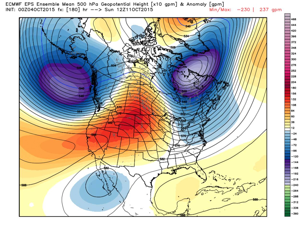
Hey Frank with the mean trough centered S of the Aleutians I would not be surprised to see the Heights increase over time over Alaska and along the west coast. It also looks like there is a hint of a block up into Greenland as well. I am going to hedge my bet and say as we get closer to this time frame the higher heights over the Plains pull back into the west and the The lower heights over N Eastern Canada pull back and center over central Canada/Hudson Bay area, and result in a continued mean trough in the east. Thoughts?
[img]
 [/img]
_________________
"In weather and in life, there's no winning and losing; there's only winning and learning."
WINTER 2012/2013 TOTALS 43.65"WINTER 2017/2018 TOTALS 62.85" WINTER 2022/2023 TOTALS 4.9"
WINTER 2013/2014 TOTALS 64.85"WINTER 2018/2019 TOTALS 14.25" WINTER 2023/2024 TOTALS 13.1"
WINTER 2014/2015 TOTALS 71.20"WINTER 2019/2020 TOTALS 6.35"
WINTER 2015/2016 TOTALS 35.00"WINTER 2020/2021 TOTALS 37.75"
WINTER 2016/2017 TOTALS 42.25"WINTER 2021/2022 TOTALS 31.65"

sroc4- Admin
- Posts : 8331
Reputation : 301
Join date : 2013-01-07
Location : Wading River, LI
Re: Long Range Thread 8.0
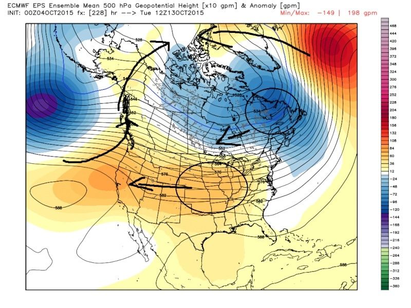
![]() by Frank_Wx Sun Oct 04, 2015 9:49 am
by Frank_Wx Sun Oct 04, 2015 9:49 am
_________________
_______________________________________________________________________________________________________
CLICK HERE to view NJ Strong Snowstorm Classifications
Frank_Wx- Godzilla Seeker
- Posts : 21305
Reputation : 328
Join date : 2013-01-05
Age : 31
Location : Jersey City, NJ -
Re: Long Range Thread 8.0
![]() by amugs Sun Oct 04, 2015 12:03 pm
by amugs Sun Oct 04, 2015 12:03 pm
This is from Isotherm- one of our member
"Its precipitation portion of the forecast continues to indicate the congregation of strongest tropical convective forcing around 170-180W, which if correct, would be favorable. This coincides well with its corresponding 500mb map which depicts the sprawling / expansive GOA vortex and concomitant W Canadian ridge immediately downstream. It's probably a mean EPO near neutral for DJF. Of course, we're still far out - so caution should be exercised. It is good to see the maintenance of its prior run's solution, however."

This i what I have been saying all along and so has Nutley that the best tropical forcing is shaping to be around the dateline - region 4 and 3.4 which really bods well for upcoming winter.
_________________
Mugs
AKA:King: Snow Weenie
Self Proclaimed
WINTER 2014-15 : 55.12" +.02 for 6 coatings (avg. 35")
WINTER 2015-16 Total - 29.8" (Avg 35")
WINTER 2016-17 : 39.5" so far
amugs- Advanced Forecaster - Mod
- Posts : 15093
Reputation : 213
Join date : 2013-01-07
Age : 54
Location : Hillsdale,NJ
Re: Long Range Thread 8.0
![]() by skinsfan1177 Sun Oct 04, 2015 12:16 pm
by skinsfan1177 Sun Oct 04, 2015 12:16 pm

skinsfan1177- Senior Enthusiast
- Posts : 4485
Reputation : 35
Join date : 2013-01-07
Age : 46
Location : Point Pleasant Boro
Re: Long Range Thread 8.0
![]() by Frank_Wx Sun Oct 04, 2015 1:29 pm
by Frank_Wx Sun Oct 04, 2015 1:29 pm
skinsfan1177 wrote:I have a couple questions what is GOA is it gulf of Aleutian. And what is DJF?
Gulf of Alaska
December-January-February
_________________
_______________________________________________________________________________________________________
CLICK HERE to view NJ Strong Snowstorm Classifications
Frank_Wx- Godzilla Seeker
- Posts : 21305
Reputation : 328
Join date : 2013-01-05
Age : 31
Location : Jersey City, NJ -
Re: Long Range Thread 8.0
![]() by rb924119 Sun Oct 04, 2015 2:15 pm
by rb924119 Sun Oct 04, 2015 2:15 pm
sroc4 wrote:Frank_Wx wrote:It may be awhile before we welcome sustained cooler weather back into our area. There's a chance next weekend we'll be below normal, but it depends on when a phase takes place between two upper air vorts in eastern Canada. Once the trough closes off, the low heights ooze over the northeast.
Then you'll notice the EPS breaks down the +PNA, the ridge flattens and the tropical Pacific air flows through the U.S.
By no means is this a warm look. We're probably going to hover around normal to slightly above. The EPS returns the trough over our area in fantasy hours because it develops the -EPO/+PNA couplet again. We'll see!
Hey Frank with the mean trough centered S of the Aleutians I would not be surprised to see the Heights increase over time over Alaska and along the west coast. It also looks like there is a hint of a block up into Greenland as well. I am going to hedge my bet and say as we get closer to this time frame the higher heights over the Plains pull back into the west and the The lower heights over N Eastern Canada pull back and center over central Canada/Hudson Bay area, and result in a continued mean trough in the east. Thoughts?
Completely agree, sroc. With a pattern that is so muted and nearly zonal, the very long wavelength dictates that it will actually retrograde west according to physics. If we can get amplification immediately following, or even concurrent with that (since it takes time for the effects to be felt downstream) it can help to change the pattern (even if it is only briefly).
rb924119- Meteorologist

- Posts : 6889
Reputation : 194
Join date : 2013-02-06
Age : 32
Location : Greentown, Pa
Re: Long Range Thread 8.0
![]() by rb924119 Sun Oct 04, 2015 2:30 pm
by rb924119 Sun Oct 04, 2015 2:30 pm

rb924119- Meteorologist
- Posts : 6889
Reputation : 194
Join date : 2013-02-06
Age : 32
Location : Greentown, Pa
Re: Long Range Thread 8.0
![]() by skinsfan1177 Sun Oct 04, 2015 2:46 pm
by skinsfan1177 Sun Oct 04, 2015 2:46 pm
Frank_Wx wrote:skinsfan1177 wrote:I have a couple questions what is GOA is it gulf of Aleutian. And what is DJF?
Gulf of Alaska
December-January-February
Thanks Frank I should of got the second one lol
skinsfan1177- Senior Enthusiast
- Posts : 4485
Reputation : 35
Join date : 2013-01-07
Age : 46
Location : Point Pleasant Boro
Re: Long Range Thread 8.0
![]() by jmanley32 Sun Oct 04, 2015 9:50 pm
by jmanley32 Sun Oct 04, 2015 9:50 pm
rb924119 wrote:HOO-CHI-MAMA!!!!! 12z EURO 'BOUTTA DELIVER THE GOODS!!!!!
Are you mentioning the coastal that it shows at 156hrs? I am no good at reading these maps but I did notice what looked like a weak coast al around that time. Lots of time to watch, could come in stronger, Lets see if Euro stays king
Why haven't I been ranting in past day or two because honestly I lost a lof of faith in the models especially out 10 days or even more. Not getting my hopes up anymore for anything that is either inconsistent far out or looks uncertain leading up to it ie. Joaquin. Not saying the latest Euro showing that system is not something to watch but right now looks like nothing impressive.
I am sure I will come around to my megaposter self soon though lol.
jmanley32- Senior Enthusiast
- Posts : 20513
Reputation : 108
Join date : 2013-12-12
Age : 42
Location : Yonkers, NY
Re: Long Range Thread 8.0
![]() by Frank_Wx Sun Oct 04, 2015 10:35 pm
by Frank_Wx Sun Oct 04, 2015 10:35 pm
rb924119 wrote:HOO-CHI-MAMA!!!!! 12z EURO 'BOUTTA DELIVER THE GOODS!!!!!
Doesn't excite me yet unless the trough over the east amplifies more. Atlantic is a mess right now. Though I could see elevated and inland zones see their first snow flakes of the season.
_________________
_______________________________________________________________________________________________________
CLICK HERE to view NJ Strong Snowstorm Classifications
Frank_Wx- Godzilla Seeker
- Posts : 21305
Reputation : 328
Join date : 2013-01-05
Age : 31
Location : Jersey City, NJ -
Re: Long Range Thread 8.0
![]() by algae888 Mon Oct 05, 2015 8:54 am
by algae888 Mon Oct 05, 2015 8:54 am

"No, the key factor is that area of cold water over the northeastern Atlantic that for some strange reason is freaking out some climate scientist. This area of cold water is old news if you study the AMO and +/-NAO patterns. In every year in which we saw a moderate to strong NAO in the winters, that cold pool of water showed up in the Fall. We saw this cold pool of water in 2009 in fact. Funny, no one made a big deal about it then, well except for Long Range Meteorologist forecasting for the Winter.
This signal is a major precursor to a sustained negative NAO pattern. Typically this area of cold water sets up a powerful thermal gradient over the northern Atlantic leading to below normal pressure to the southeast of the Canadian Maritimes, south of Greenland, and southwest of Iceland. These pressure anomalies force above normal pressure regions over Greenland and northeastern Canada which we know as the negative NAO block. This of course translates into high latitude blocking and a high potential for above normal precipitation and below normal temperatures over the Eastern United States.
Combine these factors with an active Sub Tropical jet stream and you have the makings of a rather interesting winter. Certainly the ingredients are there for a stormy winter. Cold? Well, we have to watch the snow growth in Siberia and a few other factors along the way."

algae888- Advanced Forecaster

- Posts : 5311
Reputation : 46
Join date : 2013-02-05
Age : 61
Location : mt. vernon, new york
Re: Long Range Thread 8.0
![]() by sroc4 Mon Oct 05, 2015 9:58 am
by sroc4 Mon Oct 05, 2015 9:58 am
At this time of year, weather patterns begin to set up which will tell you much of the continent will shape up during the NDJFM period. The low sun period. Autumn transitioning to winter. You know, when it should be turning colder. You also will begin to hear professional meteorologists and many in the enthusiast community make an attempt at predicting what is going to transpire across the lower 48 states. Without wanting to comment on the skills and likely results of said ventures, I will tell you how my method (analog derived) is shaping up so far.. And where I think this atmospheric road map is leading us to.
First of all, the polar jet stream is not split. It is a strong singular entity, while the subtropical flow has been setting up feeds (or fetches) over eastern Asia, near the International Dateline, across Mexico and from westernmost Africa into Europe. It appears that the strongest of these signals will be the across the central Pacific Ocean into western Alaska and just below the U.S., rolling up along the East Coast. Typically, that is a warm teleconnection to the left of the Rocky Mountains and colder from the Great Plains into the Deep South and Eastern Seaboard. A key issue here is that disturbances weaken as they cross the very warm waters along the West Coast, then regroup in the Southwest and Great Plains as moisture is present and trough axes start to form.
Another topic is El Nino. The various modeling solutions are backing down from a "super" (or, God forbid, "Godzilla") event. The infamous positive Pacific Decadal Oscillation structure, so strong for two years now, shows a bit of moderation in the Gulf of Alaska but is still quite vast and impressive (don't dare call it "The Blob"). This is probably the key element in predicting how air masses will shift and the storm track will set up. The analog method predicts a largely warm West vs. cool Central/East alignment across the U.S., with potential for a significant storm or two along a southern and eastern shoreline track. If this idea verifies, the CFS outlook for November (near-record warmth across most of the North American continent) will prove to have been as wrong as it was in September (cool when actually warmth dominated) and so far in October (cool spell in association with a major hurricane and trough after various projections of coast-to-coast heat).
Probably the key thing that is obvious in the computer models and ensembles is the return of an entrenched -AO/+PNA configuration in the 11-15 day period. Even the CFS series shows this configuration on schematic averages through the end of the month! I suspect that the warm West vs. cool/cold Central and East alignment is going to flourish after October 13. And I would not be surprised to see a late season warm-core disturbance arise in either the Bay of Campeche or Caribbean Sea in the longer term, either. The actual break to mild or warm conditions should still occur in December. But more and more, I am seeing similarities in current trends to 1957, 1965, 1972, 2009, and 2014.
In other words, one warm month followed by three cold, and California looking for rain and seeing sun and warmth.
_________________
"In weather and in life, there's no winning and losing; there's only winning and learning."
WINTER 2012/2013 TOTALS 43.65"WINTER 2017/2018 TOTALS 62.85" WINTER 2022/2023 TOTALS 4.9"
WINTER 2013/2014 TOTALS 64.85"WINTER 2018/2019 TOTALS 14.25" WINTER 2023/2024 TOTALS 13.1"
WINTER 2014/2015 TOTALS 71.20"WINTER 2019/2020 TOTALS 6.35"
WINTER 2015/2016 TOTALS 35.00"WINTER 2020/2021 TOTALS 37.75"
WINTER 2016/2017 TOTALS 42.25"WINTER 2021/2022 TOTALS 31.65"
sroc4- Admin
- Posts : 8331
Reputation : 301
Join date : 2013-01-07
Location : Wading River, LI
Re: Long Range Thread 8.0
![]() by algae888 Mon Oct 05, 2015 11:44 am
by algae888 Mon Oct 05, 2015 11:44 am

2015 oct 4th

2014
algae888- Advanced Forecaster
- Posts : 5311
Reputation : 46
Join date : 2013-02-05
Age : 61
Location : mt. vernon, new york
Re: Long Range Thread 8.0
![]() by Frank_Wx Mon Oct 05, 2015 12:02 pm
by Frank_Wx Mon Oct 05, 2015 12:02 pm
algae888 wrote:this from steve d this morning.....
"No, the key factor is that area of cold water over the northeastern Atlantic that for some strange reason is freaking out some climate scientist. This area of cold water is old news if you study the AMO and +/-NAO patterns. In every year in which we saw a moderate to strong NAO in the winters, that cold pool of water showed up in the Fall. We saw this cold pool of water in 2009 in fact. Funny, no one made a big deal about it then, well except for Long Range Meteorologist forecasting for the Winter.
This signal is a major precursor to a sustained negative NAO pattern. Typically this area of cold water sets up a powerful thermal gradient over the northern Atlantic leading to below normal pressure to the southeast of the Canadian Maritimes, south of Greenland, and southwest of Iceland. These pressure anomalies force above normal pressure regions over Greenland and northeastern Canada which we know as the negative NAO block. This of course translates into high latitude blocking and a high potential for above normal precipitation and below normal temperatures over the Eastern United States.
Combine these factors with an active Sub Tropical jet stream and you have the makings of a rather interesting winter. Certainly the ingredients are there for a stormy winter. Cold? Well, we have to watch the snow growth in Siberia and a few other factors along the way."
No offense to Steve D, but that cold pool of water in the northern Atlantic was there last winter. In his winter outlook last year he said we would see a sustained -NAO. Last winter, we did NOT see a sustained -NAO. It was transient and not very high latitudinal.
_________________
_______________________________________________________________________________________________________
CLICK HERE to view NJ Strong Snowstorm Classifications
Frank_Wx- Godzilla Seeker
- Posts : 21305
Reputation : 328
Join date : 2013-01-05
Age : 31
Location : Jersey City, NJ -
Re: Long Range Thread 8.0
![]() by nutleyblizzard Mon Oct 05, 2015 12:31 pm
by nutleyblizzard Mon Oct 05, 2015 12:31 pm

nutleyblizzard- Senior Enthusiast
- Posts : 1952
Reputation : 41
Join date : 2014-01-30
Age : 58
Location : Nutley, new jersey
Re: Long Range Thread 8.0
![]() by sroc4 Mon Oct 05, 2015 2:03 pm
by sroc4 Mon Oct 05, 2015 2:03 pm
Last year if you recall we had that crazy QBO. We had that persistent 300-250mb Jet streak over the Pac (whether the QBO was the cause of this is debatable) for the majority of the first half of the winter, and we also had what appeared to be a weak El Nino. The only problem with the El Nino last year is that the atmoshphere, STJ and MJO, did not seem to behave quite like a typical weak El Nino. Which if you recall Frank you and I had a small debate about.
What appears to be quite evident; however, is that the pattern in the west is vastly different this season relative to last. Clearly we have a moderate to strong el nino event firmly in place, so given the current state of SST anomalies in the Atlantic, AKA the AMO, I believe there is a much better chance to see that -NAO show up with some consistency assuming it follows the recongnized tendancies.
I will try and post graphics later with SST anomalies and AMO/NAO relationship graphs later if I have the time since Im at work.
_________________
"In weather and in life, there's no winning and losing; there's only winning and learning."
WINTER 2012/2013 TOTALS 43.65"WINTER 2017/2018 TOTALS 62.85" WINTER 2022/2023 TOTALS 4.9"
WINTER 2013/2014 TOTALS 64.85"WINTER 2018/2019 TOTALS 14.25" WINTER 2023/2024 TOTALS 13.1"
WINTER 2014/2015 TOTALS 71.20"WINTER 2019/2020 TOTALS 6.35"
WINTER 2015/2016 TOTALS 35.00"WINTER 2020/2021 TOTALS 37.75"
WINTER 2016/2017 TOTALS 42.25"WINTER 2021/2022 TOTALS 31.65"
sroc4- Admin
- Posts : 8331
Reputation : 301
Join date : 2013-01-07
Location : Wading River, LI
Re: Long Range Thread 8.0
![]() by nutleyblizzard Mon Oct 05, 2015 2:28 pm
by nutleyblizzard Mon Oct 05, 2015 2:28 pm
nutleyblizzard- Senior Enthusiast
- Posts : 1952
Reputation : 41
Join date : 2014-01-30
Age : 58
Location : Nutley, new jersey
Re: Long Range Thread 8.0
![]() by amugs Mon Oct 05, 2015 2:42 pm
by amugs Mon Oct 05, 2015 2:42 pm
This is excellent news

Heer is teh 31 day loop to see my PUP grow!!
http://www.natice.noaa.gov/ims/loop/nhem-1mo-loop.html
_________________
Mugs
AKA:King: Snow Weenie
Self Proclaimed
WINTER 2014-15 : 55.12" +.02 for 6 coatings (avg. 35")
WINTER 2015-16 Total - 29.8" (Avg 35")
WINTER 2016-17 : 39.5" so far
amugs- Advanced Forecaster - Mod
- Posts : 15093
Reputation : 213
Join date : 2013-01-07
Age : 54
Location : Hillsdale,NJ
Re: Long Range Thread 8.0
![]() by amugs Mon Oct 05, 2015 3:00 pm
by amugs Mon Oct 05, 2015 3:00 pm
nutleyblizzard wrote:https://twitter.com/philklotzbach/status/651069828740984832Things are looking great for us with the warm anomalies in the 3.4 region. Best forcing looks to be setting up by the dateline.
Nutley,
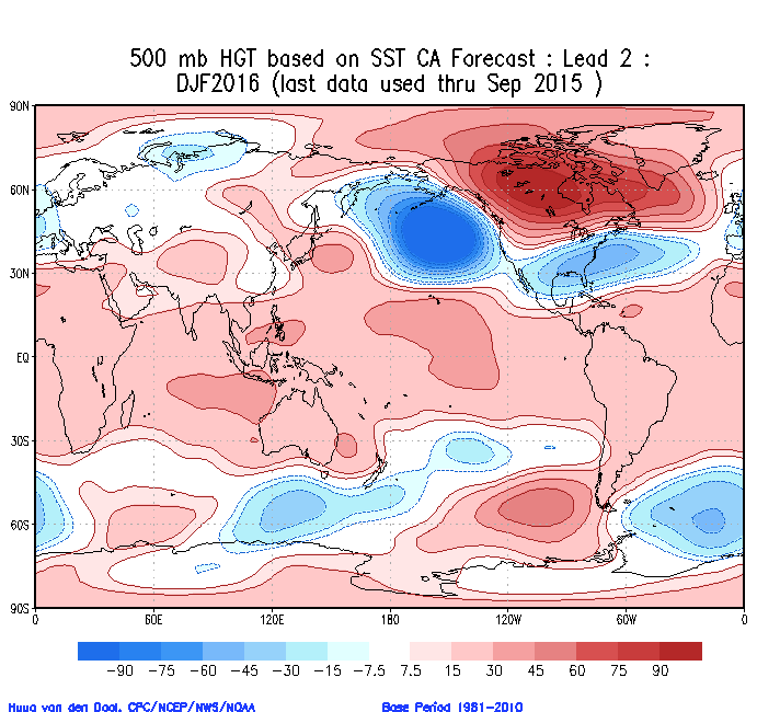
This is absolutely fantastic news - as I have and I know you have as well on here been harping since the summer or late summer how important for our dear winter it is for this area of the EPAC to be warm and it is a Vasin Wide event and it set up near the dateline - that is the trop forcing. If we can get region 4 to warm as much and I think it is then we will be in good shape for this upcoming winter. Hey, next year we are looking at La Nada/Nina so let's get it while and if we can. If it is a back loaded winter as we have seen in the past then fine no problem but if we can get a cold December like 2002-03 then we are in big business. QBO postive which is okay at this point tis from Isotherm :September 30mb QBO value has risen to +12.07, solidly westerly. Will be another factor to monitor for the ensuing winter. Very high likelihood that the QBO will average positive for DJFM.
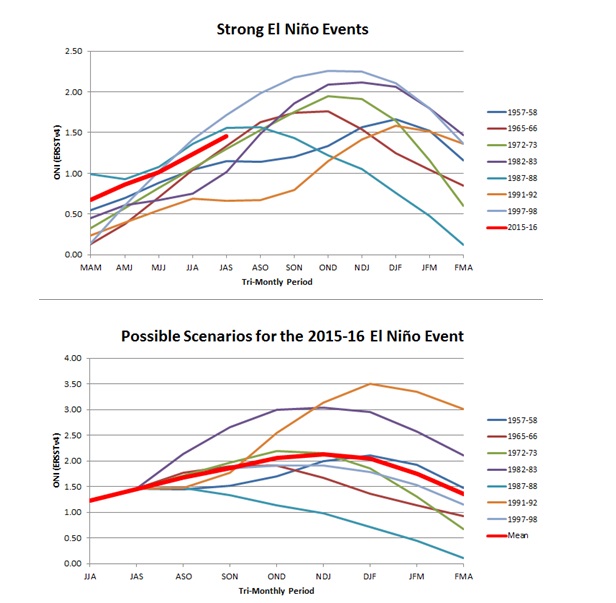
This is where we are at :
_________________
Mugs
AKA:King: Snow Weenie
Self Proclaimed
WINTER 2014-15 : 55.12" +.02 for 6 coatings (avg. 35")
WINTER 2015-16 Total - 29.8" (Avg 35")
WINTER 2016-17 : 39.5" so far
amugs- Advanced Forecaster - Mod
- Posts : 15093
Reputation : 213
Join date : 2013-01-07
Age : 54
Location : Hillsdale,NJ
Re: Long Range Thread 8.0
![]() by Frank_Wx Mon Oct 05, 2015 5:28 pm
by Frank_Wx Mon Oct 05, 2015 5:28 pm

1972-1973, another Nino year, the AMO was also negative and the NAO was positive

Obviously these correlations are looked at as black and white, but the NAO/AMO correlation is difficult to understand during El Nino events
_________________
_______________________________________________________________________________________________________
CLICK HERE to view NJ Strong Snowstorm Classifications
Frank_Wx- Godzilla Seeker
- Posts : 21305
Reputation : 328
Join date : 2013-01-05
Age : 31
Location : Jersey City, NJ -
Page 16 of 40 • 1 ... 9 ... 15, 16, 17 ... 28 ... 40 ![]()
|
|
|