
 Search
Long Range Thread 11.0
Page 10 of 27 •  1 ... 6 ... 9, 10, 11 ... 18 ... 27
 ![]()
Re: Long Range Thread 11.0
![]() by algae888 Mon Mar 14, 2016 3:25 am
by algae888 Mon Mar 14, 2016 3:25 am


algae888- Advanced Forecaster

- Posts : 5311
Join date : 2013-02-05
Re: Long Range Thread 11.0
![]() by algae888 Mon Mar 14, 2016 9:05 am
by algae888 Mon Mar 14, 2016 9:05 am

algae888- Advanced Forecaster
- Posts : 5311
Join date : 2013-02-05


algae888- Advanced Forecaster
- Posts : 5311
Reputation : 46
Join date : 2013-02-05
Age : 61
Location : mt. vernon, new york
Re: Long Range Thread 11.0
![]() by sroc4 Mon Mar 14, 2016 9:31 am
by sroc4 Mon Mar 14, 2016 9:31 am
sroc4 wrote:I dont expect anyone to take this seriously given the current temps, BUT IF there is going to be one last chance at winter weather it will be between March 20th-25th. Both the GEFS and the EPS are signaling at a -EPO/-AO/-NAO with a trough in the east. Obv probabilities are low but the signal is there." />
" />
Quick update on the pattern. If one last storm is going to come to fruition given the current drivers Im pretty sure you need to have some of the teles on your side. If one were hoping for one last winter system(and yes I am) to affect the northeast in a pattern that has been dominated by a strong STJ you first have to look to see if there will be a source of cold air. A -EPO is a great teleconnection to have on your side. That blocking feature promotes cold arctic and/or canadian HP to drop into the conus. Key for this time of year if you want winter precip. Last March was dominated by this blocking feature and was probably the single most important driver to why I had over 26" of snow IMBY for the month of March. That being said this March is not like last in that instead of a weak el nino percolating we have one of the strongest ever declining and an extremely potent STJ. So we are going to need more than just a neg EPO for a system to come together IMO. Enter in the NAO. It is forecast to drop neg. between the 16th-18th, and fairly significantly, seen both graphically(about 2 standard deviations) and on the 500mb anomaly maps in both the European and American modeling. It is not uncommon to see a system come to fruition in the NE when teleconnections, esp the NAO, are transitioning from one state to another...Jan23rd 2016 one case in point. This too(-NAO transitioning back towards neutral) is loosely forecast to occur around the time frame in question(between 20th-25th).
Now lets briefly look back upon the images above. These were the EPS, and GEFS from March 9th. Now lets look below and see how the pattern has evolved, or more appropriate, how the modeling has evolved. Key points:
1) The trend has been to bring the negatives west and develop the trough S of the Aleutians.
2) EPO blocking is trending stronger.
3) The -NAO is present; however, it is an east based one by the current looks of things.
4) Notice that by pulling the negatives off the west coast and concentrating them into a trough S of the Aleutians it allows the +PNA ridge to spring up.
5) I really like how the Positive heights to our NE in the Canadian maritime are trending weaker rather than stronger on the GEFS.
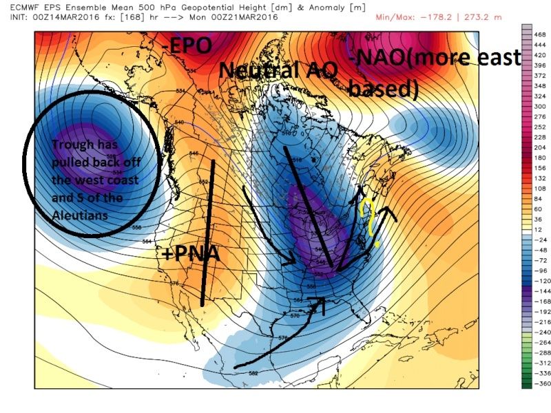

So what is all this telling me. I am gaining confidence that the pattern is setting up the possibility for at least one; maybe two, systems to come together somewhere in the NE between the 20th-25th. The operational models have been hinting at this now for several days, as they have had these systems come and go, left and right, up and down, as is to be expected at this range. If a system were to come together climatology is such that the time of day may factor into precip types, but let me not get ahead of myself here. The pattern is such that if the timing is right with the energy associated with said systems, there will be/should be enough cold air around to promote winter precip. Obviously track will be key to if any of us see any of it. At this stage all I can ask for is a pattern that would support a winter event IMBY, which has absolutely been evolving more favorably in the modeling; however, with the track record of this winter it would not surprise me to cont to see big changes on the modeling, for better or worse, as we enter into the medium and short range. For that reason my confidence is still low. The trough will likely be transient and ridging back into the east will likely return after this time frame.
_________________
"In weather and in life, there's no winning and losing; there's only winning and learning."
WINTER 2012/2013 TOTALS 43.65"WINTER 2017/2018 TOTALS 62.85" WINTER 2022/2023 TOTALS 4.9"
WINTER 2013/2014 TOTALS 64.85"WINTER 2018/2019 TOTALS 14.25" WINTER 2023/2024 TOTALS 13.1"
WINTER 2014/2015 TOTALS 71.20"WINTER 2019/2020 TOTALS 6.35"
WINTER 2015/2016 TOTALS 35.00"WINTER 2020/2021 TOTALS 37.75"
WINTER 2016/2017 TOTALS 42.25"WINTER 2021/2022 TOTALS 31.65"

sroc4- Admin

- Posts : 8331
Reputation : 301
Join date : 2013-01-07
Location : Wading River, LI


Snow88- Senior Enthusiast

- Posts : 2193
Reputation : 4
Join date : 2013-01-09
Age : 35
Location : Brooklyn, NY
Re: Long Range Thread 11.0
![]() by sroc4 Mon Mar 14, 2016 9:56 am
by sroc4 Mon Mar 14, 2016 9:56 am
Snow88 wrote:CFSv2 until April 8

_________________
"In weather and in life, there's no winning and losing; there's only winning and learning."
WINTER 2012/2013 TOTALS 43.65"WINTER 2017/2018 TOTALS 62.85" WINTER 2022/2023 TOTALS 4.9"
WINTER 2013/2014 TOTALS 64.85"WINTER 2018/2019 TOTALS 14.25" WINTER 2023/2024 TOTALS 13.1"
WINTER 2014/2015 TOTALS 71.20"WINTER 2019/2020 TOTALS 6.35"
WINTER 2015/2016 TOTALS 35.00"WINTER 2020/2021 TOTALS 37.75"
WINTER 2016/2017 TOTALS 42.25"WINTER 2021/2022 TOTALS 31.65"
sroc4- Admin
- Posts : 8331
Reputation : 301
Join date : 2013-01-07
Location : Wading River, LI
Re: Long Range Thread 11.0
![]() by jmanley32 Mon Mar 14, 2016 11:27 am
by jmanley32 Mon Mar 14, 2016 11:27 am
sroc4 wrote:Snow88 wrote:CFSv2 until April 8
2-4 feet over the next 45 days, ya okayyyyy (what is the track record of this model?), then again this year has been wacky as heck.

jmanley32- Senior Enthusiast
- Posts : 20517
Reputation : 108
Join date : 2013-12-12
Age : 42
Location : Yonkers, NY
Snow88- Senior Enthusiast
- Posts : 2193
Reputation : 4
Join date : 2013-01-09
Age : 35
Location : Brooklyn, NY
Re: Long Range Thread 11.0
![]() by algae888 Mon Mar 14, 2016 2:43 pm
by algae888 Mon Mar 14, 2016 2:43 pm


does anyone have precip maps and snow totals
algae888- Advanced Forecaster
- Posts : 5311
Reputation : 46
Join date : 2013-02-05
Age : 61
Location : mt. vernon, new york
Re: Long Range Thread 11.0
![]() by algae888 Mon Mar 14, 2016 2:52 pm
by algae888 Mon Mar 14, 2016 2:52 pm

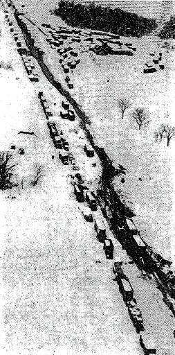
The Pennsylvania Turnpike (Near Morgantown, Pennsylvania). Accumulations included: Allentown: 20.3"; Baltimore: 8.4"; Boston: 6.7"; Bridgeport: 9.3"; Morgantown, PA: 50.0"; New York City: 11.7"; Newark, NJ: 14.8"; Philadelphia: 11.4"; and, Worcester: 18.8"
Source: The New York Times, March 22, 1958 (Associated Press Wirephoto)
algae888- Advanced Forecaster
- Posts : 5311
Reputation : 46
Join date : 2013-02-05
Age : 61
Location : mt. vernon, new york
Re: Long Range Thread 11.0
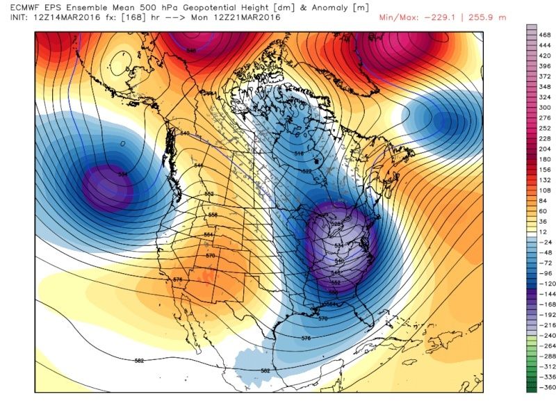
![]() by algae888 Mon Mar 14, 2016 3:02 pm
by algae888 Mon Mar 14, 2016 3:02 pm
algae888- Advanced Forecaster
- Posts : 5311
Reputation : 46
Join date : 2013-02-05
Age : 61
Location : mt. vernon, new york
Re: Long Range Thread 11.0
![]() by sroc4 Mon Mar 14, 2016 3:19 pm
by sroc4 Mon Mar 14, 2016 3:19 pm
_________________
"In weather and in life, there's no winning and losing; there's only winning and learning."
WINTER 2012/2013 TOTALS 43.65"WINTER 2017/2018 TOTALS 62.85" WINTER 2022/2023 TOTALS 4.9"
WINTER 2013/2014 TOTALS 64.85"WINTER 2018/2019 TOTALS 14.25" WINTER 2023/2024 TOTALS 13.1"
WINTER 2014/2015 TOTALS 71.20"WINTER 2019/2020 TOTALS 6.35"
WINTER 2015/2016 TOTALS 35.00"WINTER 2020/2021 TOTALS 37.75"
WINTER 2016/2017 TOTALS 42.25"WINTER 2021/2022 TOTALS 31.65"
sroc4- Admin
- Posts : 8331
Reputation : 301
Join date : 2013-01-07
Location : Wading River, LI
Re: Long Range Thread 11.0
![]() by algae888 Mon Mar 14, 2016 3:24 pm
by algae888 Mon Mar 14, 2016 3:24 pm
euro snow map. lovely. where are all the diehard snow weenies???

algae888- Advanced Forecaster
- Posts : 5311
Reputation : 46
Join date : 2013-02-05
Age : 61
Location : mt. vernon, new york
Re: Long Range Thread 11.0
![]() by algae888 Mon Mar 14, 2016 3:28 pm
by algae888 Mon Mar 14, 2016 3:28 pm
scott probabilities are probably less than 20% for cutter and 40-40 for bomb and weak ots solutions (missed phase). that's my guess right nowsroc4 wrote:It may not pan out but I didnt hear no fat lady just yet
algae888- Advanced Forecaster
- Posts : 5311
Reputation : 46
Join date : 2013-02-05
Age : 61
Location : mt. vernon, new york
Re: Long Range Thread 11.0
![]() by Snow88 Mon Mar 14, 2016 3:29 pm
by Snow88 Mon Mar 14, 2016 3:29 pm
http://www.cpc.ncep.noaa.gov/products/precip/CWlink/daily_ao_index/ao.sprd2.gif
Snow88- Senior Enthusiast
- Posts : 2193
Reputation : 4
Join date : 2013-01-09
Age : 35
Location : Brooklyn, NY
Re: Long Range Thread 11.0
![]() by jake732 Mon Mar 14, 2016 3:32 pm
by jake732 Mon Mar 14, 2016 3:32 pm

jake732- Pro Enthusiast

- Posts : 449
Reputation : 0
Join date : 2016-01-03
Location : lakewood, nj -

Re: Long Range Thread 11.0
![]() by Snow88 Mon Mar 14, 2016 3:35 pm
by Snow88 Mon Mar 14, 2016 3:35 pm
jake732 wrote:its to late in the season it just wont happen. maybe snow way way north. euro will come to this as well.
We have seen snow in March and April many times near the coast and inland. It's not too late.
Snow88- Senior Enthusiast
- Posts : 2193
Reputation : 4
Join date : 2013-01-09
Age : 35
Location : Brooklyn, NY
Re: Long Range Thread 11.0
![]() by sroc4 Mon Mar 14, 2016 3:42 pm
by sroc4 Mon Mar 14, 2016 3:42 pm
algae888 wrote:scott probabilities are probably less than 20% for cutter and 40-40 for bomb and weak ots solutions (missed phase). that's my guess right nowsroc4 wrote:It may not pan out but I didnt hear no fat lady just yet
One thing I would say about the cutter idea is if the ridging to our NE trends stronger (which has hurt us in the recent past as we approached the md and shrt range) it will likely lead to a further west idea and a warmer soln. Im going to stick with saying there is a 100% chance the system either happens or it doesnt for now.
_________________
"In weather and in life, there's no winning and losing; there's only winning and learning."
WINTER 2012/2013 TOTALS 43.65"WINTER 2017/2018 TOTALS 62.85" WINTER 2022/2023 TOTALS 4.9"
WINTER 2013/2014 TOTALS 64.85"WINTER 2018/2019 TOTALS 14.25" WINTER 2023/2024 TOTALS 13.1"
WINTER 2014/2015 TOTALS 71.20"WINTER 2019/2020 TOTALS 6.35"
WINTER 2015/2016 TOTALS 35.00"WINTER 2020/2021 TOTALS 37.75"
WINTER 2016/2017 TOTALS 42.25"WINTER 2021/2022 TOTALS 31.65"
sroc4- Admin
- Posts : 8331
Reputation : 301
Join date : 2013-01-07
Location : Wading River, LI
Re: Long Range Thread 11.0
![]() by sroc4 Mon Mar 14, 2016 3:45 pm
by sroc4 Mon Mar 14, 2016 3:45 pm
jake732 wrote:its to late in the season it just wont happen. maybe snow way way north. euro will come to this as well.
This is banter. Please keep it in there. Here is a link to the monthly snowfall by year in CPK. Simply scroll down and see just how many years CPK has had snow in March and April. Last year I had 12.25" after March 20th. Although it may not pan out IT IS NOT TOO LATE IN THE SEASON.
http://www.weather.gov/media/okx/Climate/CentralPark/monthlyseasonalsnowfall.pdf
_________________
"In weather and in life, there's no winning and losing; there's only winning and learning."
WINTER 2012/2013 TOTALS 43.65"WINTER 2017/2018 TOTALS 62.85" WINTER 2022/2023 TOTALS 4.9"
WINTER 2013/2014 TOTALS 64.85"WINTER 2018/2019 TOTALS 14.25" WINTER 2023/2024 TOTALS 13.1"
WINTER 2014/2015 TOTALS 71.20"WINTER 2019/2020 TOTALS 6.35"
WINTER 2015/2016 TOTALS 35.00"WINTER 2020/2021 TOTALS 37.75"
WINTER 2016/2017 TOTALS 42.25"WINTER 2021/2022 TOTALS 31.65"
sroc4- Admin
- Posts : 8331
Reputation : 301
Join date : 2013-01-07
Location : Wading River, LI
Re: Long Range Thread 11.0
![]() by Quietace Mon Mar 14, 2016 3:57 pm
by Quietace Mon Mar 14, 2016 3:57 pm
Based on general climatology of the area, Scott is correct. It is irrational to broadbrush a synoptic set up that is favorable for EC cyclogenesis due to a date on a calendar.sroc4 wrote:jake732 wrote:its to late in the season it just wont happen. maybe snow way way north. euro will come to this as well.
This is banter. Please keep it in there. Here is a link to the monthly snowfall by year in CPK. Simply scroll down and see just how many years CPK has had snow in March and April. Last year I had 12.25" after March 20th. Although it may not pan out IT IS NOT TOO LATE IN THE SEASON.
http://www.weather.gov/media/okx/Climate/CentralPark/monthlyseasonalsnowfall.pdf

Quietace- Meteorologist - Mod

- Posts : 3687
Reputation : 33
Join date : 2013-01-07
Age : 27
Location : Point Pleasant, NJ
Re: Long Range Thread 11.0
![]() by frank 638 Mon Mar 14, 2016 4:22 pm
by frank 638 Mon Mar 14, 2016 4:22 pm
frank 638- Senior Enthusiast
- Posts : 2825
Reputation : 37
Join date : 2016-01-01
Age : 40
Location : bronx ny


algae888- Advanced Forecaster
- Posts : 5311
Reputation : 46
Join date : 2013-02-05
Age : 61
Location : mt. vernon, new york
Re: Long Range Thread 11.0
![]() by algae888 Mon Mar 14, 2016 4:45 pm
by algae888 Mon Mar 14, 2016 4:45 pm

also note how pv energy gets pulled into the trough
algae888- Advanced Forecaster
- Posts : 5311
Reputation : 46
Join date : 2013-02-05
Age : 61
Location : mt. vernon, new york

algae888- Advanced Forecaster
- Posts : 5311
Reputation : 46
Join date : 2013-02-05
Age : 61
Location : mt. vernon, new york
Re: Long Range Thread 11.0
![]() by sroc4 Mon Mar 14, 2016 4:50 pm
by sroc4 Mon Mar 14, 2016 4:50 pm
_________________
"In weather and in life, there's no winning and losing; there's only winning and learning."
WINTER 2012/2013 TOTALS 43.65"WINTER 2017/2018 TOTALS 62.85" WINTER 2022/2023 TOTALS 4.9"
WINTER 2013/2014 TOTALS 64.85"WINTER 2018/2019 TOTALS 14.25" WINTER 2023/2024 TOTALS 13.1"
WINTER 2014/2015 TOTALS 71.20"WINTER 2019/2020 TOTALS 6.35"
WINTER 2015/2016 TOTALS 35.00"WINTER 2020/2021 TOTALS 37.75"
WINTER 2016/2017 TOTALS 42.25"WINTER 2021/2022 TOTALS 31.65"
sroc4- Admin
- Posts : 8331
Reputation : 301
Join date : 2013-01-07
Location : Wading River, LI
Re: Long Range Thread 11.0
![]() by algae888 Mon Mar 14, 2016 5:09 pm
by algae888 Mon Mar 14, 2016 5:09 pm
algae888- Advanced Forecaster
- Posts : 5311
Reputation : 46
Join date : 2013-02-05
Age : 61
Location : mt. vernon, new york
Re: Long Range Thread 11.0
![]() by Frank_Wx Mon Mar 14, 2016 6:20 pm
by Frank_Wx Mon Mar 14, 2016 6:20 pm


_________________
_______________________________________________________________________________________________________
CLICK HERE to view NJ Strong Snowstorm Classifications

Frank_Wx- Godzilla Seeker
- Posts : 21305
Reputation : 328
Join date : 2013-01-05
Age : 31
Location : Jersey City, NJ -
Page 10 of 27 • 1 ... 6 ... 9, 10, 11 ... 18 ... 27 ![]()
|
|
|