
 Search
2016 Tropical Cyclone Discussions
Page 21 of 33 •  1 ... 12 ... 20, 21, 22 ... 27 ... 33
 ![]()
Re: 2016 Tropical Cyclone Discussions
![]() by sroc4 Fri Sep 09, 2016 1:33 pm
by sroc4 Fri Sep 09, 2016 1:33 pm
sroc4- Admin

- Posts : 8331
Join date : 2013-01-07
Re: 2016 Tropical Cyclone Discussions
![]() by jmanley32 Fri Sep 09, 2016 2:04 pm
by jmanley32 Fri Sep 09, 2016 2:04 pm
jmanley32- Senior Enthusiast

- Posts : 20517
Join date : 2013-12-12
Re: 2016 Tropical Cyclone Discussions
![]() by sroc4 Fri Sep 09, 2016 2:40 pm
by sroc4 Fri Sep 09, 2016 2:40 pm
_________________
"In weather and in life, there's no winning and losing; there's only winning and learning."
WINTER 2012/2013 TOTALS 43.65"WINTER 2017/2018 TOTALS 62.85" WINTER 2022/2023 TOTALS 4.9"
WINTER 2013/2014 TOTALS 64.85"WINTER 2018/2019 TOTALS 14.25" WINTER 2023/2024 TOTALS 13.1"
WINTER 2014/2015 TOTALS 71.20"WINTER 2019/2020 TOTALS 6.35"
WINTER 2015/2016 TOTALS 35.00"WINTER 2020/2021 TOTALS 37.75"
WINTER 2016/2017 TOTALS 42.25"WINTER 2021/2022 TOTALS 31.65"

sroc4- Admin
- Posts : 8331
Reputation : 301
Join date : 2013-01-07
Location : Wading River, LI
Re: 2016 Tropical Cyclone Discussions
![]() by jmanley32 Fri Sep 09, 2016 5:47 pm
by jmanley32 Fri Sep 09, 2016 5:47 pm

jmanley32- Senior Enthusiast
- Posts : 20517
Reputation : 108
Join date : 2013-12-12
Age : 42
Location : Yonkers, NY


Snow88- Senior Enthusiast
- Posts : 2193
Reputation : 4
Join date : 2013-01-09
Age : 35
Location : Brooklyn, NY
Re: 2016 Tropical Cyclone Discussions
![]() by NjWeatherGuy Sat Sep 10, 2016 3:44 am
by NjWeatherGuy Sat Sep 10, 2016 3:44 am
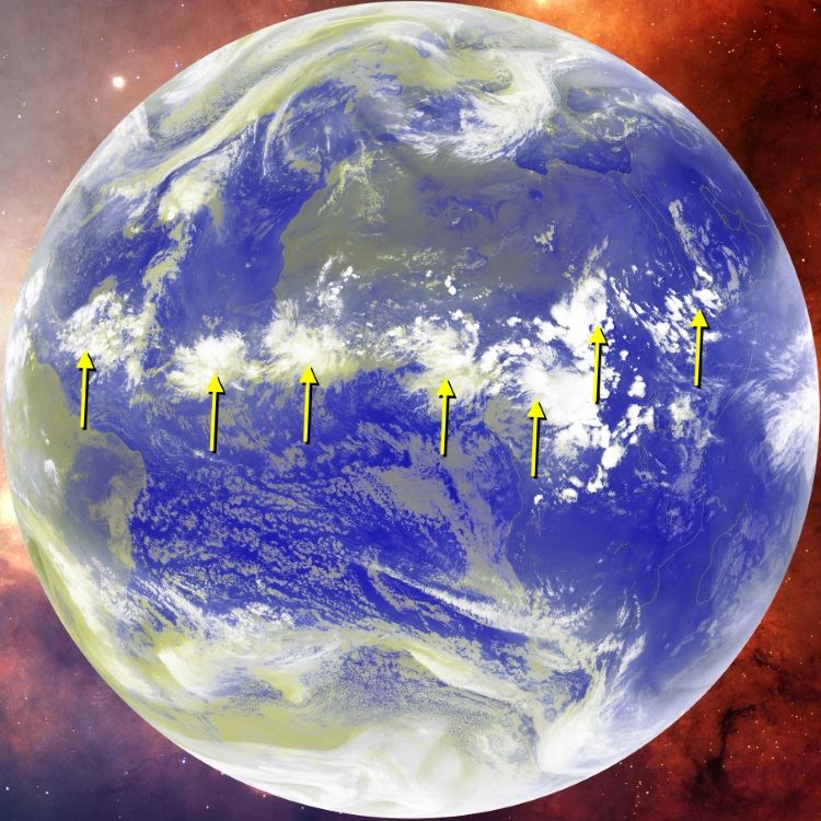
sroc4 wrote:It may look like nothing is imminent but I would not look at surface maps on LR projections to see if the tropics are active. I hope we have learned by what has happened over the past two weeks tracking 99l/TD9/Hermine that anything beyond a few days can be extremely unpredictable regarding tropical cyclone formation and/or predictions. That said here is an image taken from Larry Cosgrove noting the next 7 Tropical waves that need to me monitored over time. Just because the current modeling doesnt have anything specific developing now doesn't mean that it isnt going to be active. Id be willing to be that out of the blue we will see development. IMO more than likely it will be as one of these waves gets beyond 60W that the modeling catches on.
Here too is LC write up on the upcoming tropics. This was written on Sept 5th BTW:
Just a quick note/reminder that we are not done with the 2016 hurricane season. With the Hermine travesty starting to fade off the coast of the Northeast, attentions now turn to other threats for tropical cyclone development.
The first place to check is the African ITCZ. We should be able to squeeze out four or five more weeks of "Cape Verde" disturbances before the season does its "end zone" dances in the western Atlantic Basin. Note that there are seven well-defined impulses in a band from well south and west of the Cape Verde Islands all the way to Djibouti. It normally takes five stronger waves to guarantee a depression or named storm that reaches the major islands and/or U.S., so at least one important system should arise from this series.
There is also the matter of the already impressive Invest 92L, now zeroing in on Puerto Rico. This disturbance is unlikely to develop until it gets past Hispaniola and Cuba, in about three days. Entering the open Gulf of Mexico in late week, I foresee the system acquiring a closed circulation and strengthening trend as it moves into a trans-ridge weakness well south of Louisiana and Texas. I am following a blend of the ECMWF and GGEM schemes in moving a more-developed depression or tropical storm into the western Gulf Coast at some point in about 8 or 9 days from now.
And there will be more chances. Much of the western Atlantic Basin is still quite warm, and the upper atmospheric and temperature alignment that would support a storm strike in the eastern third of the U.S. looks to remain in place through the first half of October. With this being a weak La Nina set-up, the analogs of 1954 and 1995warn us of possible storm risks to Appalachia and the Eastern Seaboard. My suspicion is that repeated cycle of hot and humid periods will end in the eastern half of the country only after such a storm, in concert with a trough and cold front, exist the scene.
Bottom line "it ain't over 'til it's over", my friends....
Agreed, I believe we will see the Gaston-like projected track wave (forgot invest name) become a TD within a couple days at most. Looking more organized but sti fighting some dry air.

NjWeatherGuy- Advanced Forecaster

- Posts : 4100
Reputation : 28
Join date : 2013-01-06
Location : Belle Mead, NJ
Re: 2016 Tropical Cyclone Discussions
![]() by jmanley32 Sun Sep 11, 2016 7:08 pm
by jmanley32 Sun Sep 11, 2016 7:08 pm
jmanley32- Senior Enthusiast
- Posts : 20517
Reputation : 108
Join date : 2013-12-12
Age : 42
Location : Yonkers, NY
Re: 2016 Tropical Cyclone Discussions
![]() by sroc4 Sun Sep 11, 2016 9:08 pm
by sroc4 Sun Sep 11, 2016 9:08 pm
jmanley32 wrote:Well models are not impressed with tropics through the end of the month, I know sometimes things pop up but I do not even see the slightest signs of LP other than one or two fish storms, mugs I think unless october is overactive your report from that other met may be incorrect. If we go quietly out with hurricane season we better see some good noreasters and snow storms.
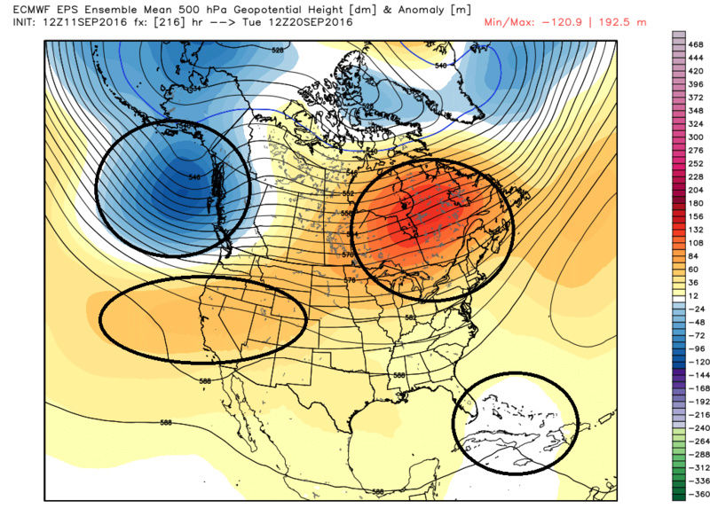
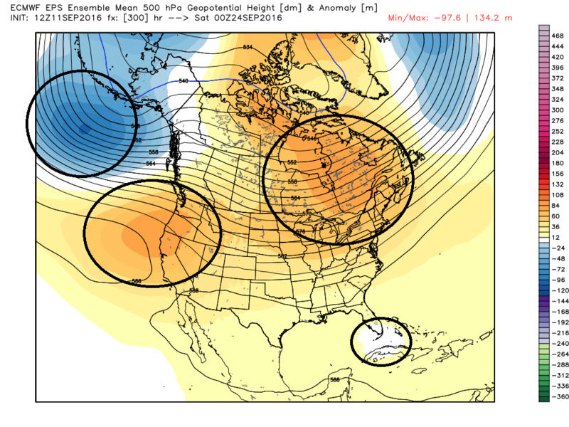
Keep an eye on Sept 20th-25th. EPS is hinting at strong positive anomalies (ridging) to the north with negatives lurking underneath somewhere around the Bahamas/Turks And Caicos/Carribean/SE area in this time frame. Whether its nothing more than a tropical wave or something actually spins up is yet to be determined.
_________________
"In weather and in life, there's no winning and losing; there's only winning and learning."
WINTER 2012/2013 TOTALS 43.65"WINTER 2017/2018 TOTALS 62.85" WINTER 2022/2023 TOTALS 4.9"
WINTER 2013/2014 TOTALS 64.85"WINTER 2018/2019 TOTALS 14.25" WINTER 2023/2024 TOTALS 13.1"
WINTER 2014/2015 TOTALS 71.20"WINTER 2019/2020 TOTALS 6.35"
WINTER 2015/2016 TOTALS 35.00"WINTER 2020/2021 TOTALS 37.75"
WINTER 2016/2017 TOTALS 42.25"WINTER 2021/2022 TOTALS 31.65"
sroc4- Admin
- Posts : 8331
Reputation : 301
Join date : 2013-01-07
Location : Wading River, LI
Re: 2016 Tropical Cyclone Discussions
![]() by jmanley32 Mon Sep 12, 2016 3:13 pm
by jmanley32 Mon Sep 12, 2016 3:13 pm
jmanley32- Senior Enthusiast
- Posts : 20517
Reputation : 108
Join date : 2013-12-12
Age : 42
Location : Yonkers, NY
Re: 2016 Tropical Cyclone Discussions
![]() by sroc4 Tue Sep 13, 2016 3:39 pm
by sroc4 Tue Sep 13, 2016 3:39 pm
Maximum Winds: 165 kt 189.9mph sustained with gusts to 225mph
Minimum Central Pressure: 887 mb

_________________
"In weather and in life, there's no winning and losing; there's only winning and learning."
WINTER 2012/2013 TOTALS 43.65"WINTER 2017/2018 TOTALS 62.85" WINTER 2022/2023 TOTALS 4.9"
WINTER 2013/2014 TOTALS 64.85"WINTER 2018/2019 TOTALS 14.25" WINTER 2023/2024 TOTALS 13.1"
WINTER 2014/2015 TOTALS 71.20"WINTER 2019/2020 TOTALS 6.35"
WINTER 2015/2016 TOTALS 35.00"WINTER 2020/2021 TOTALS 37.75"
WINTER 2016/2017 TOTALS 42.25"WINTER 2021/2022 TOTALS 31.65"
sroc4- Admin
- Posts : 8331
Reputation : 301
Join date : 2013-01-07
Location : Wading River, LI
Re: 2016 Tropical Cyclone Discussions
![]() by Frank_Wx Tue Sep 13, 2016 5:17 pm
by Frank_Wx Tue Sep 13, 2016 5:17 pm
_________________
_______________________________________________________________________________________________________
CLICK HERE to view NJ Strong Snowstorm Classifications

Frank_Wx- Godzilla Seeker
- Posts : 21305
Reputation : 328
Join date : 2013-01-05
Age : 31
Location : Jersey City, NJ -

Re: 2016 Tropical Cyclone Discussions
![]() by Frank_Wx Tue Sep 13, 2016 5:42 pm
by Frank_Wx Tue Sep 13, 2016 5:42 pm
https://twitter.com/nj_strong_wx/status/775811736746287104
_________________
_______________________________________________________________________________________________________
CLICK HERE to view NJ Strong Snowstorm Classifications
Frank_Wx- Godzilla Seeker
- Posts : 21305
Reputation : 328
Join date : 2013-01-05
Age : 31
Location : Jersey City, NJ -
Re: 2016 Tropical Cyclone Discussions
![]() by amugs Tue Sep 13, 2016 6:00 pm
by amugs Tue Sep 13, 2016 6:00 pm

Last edited by amugs on Tue Sep 13, 2016 6:51 pm; edited 1 time in total
_________________
Mugs
AKA:King: Snow Weenie
Self Proclaimed
WINTER 2014-15 : 55.12" +.02 for 6 coatings (avg. 35")
WINTER 2015-16 Total - 29.8" (Avg 35")
WINTER 2016-17 : 39.5" so far

amugs- Advanced Forecaster - Mod

- Posts : 15093
Reputation : 213
Join date : 2013-01-07
Age : 54
Location : Hillsdale,NJ
Re: 2016 Tropical Cyclone Discussions
![]() by sroc4 Tue Sep 13, 2016 6:41 pm
by sroc4 Tue Sep 13, 2016 6:41 pm
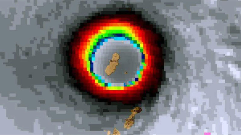
Frank_Wx wrote:Omg
https://twitter.com/nj_strong_wx/status/775811736746287104
It's like an EF 5 tornado 10-20miles wide. That island was likely demolished. God help anyone that lives there.
_________________
"In weather and in life, there's no winning and losing; there's only winning and learning."
WINTER 2012/2013 TOTALS 43.65"WINTER 2017/2018 TOTALS 62.85" WINTER 2022/2023 TOTALS 4.9"
WINTER 2013/2014 TOTALS 64.85"WINTER 2018/2019 TOTALS 14.25" WINTER 2023/2024 TOTALS 13.1"
WINTER 2014/2015 TOTALS 71.20"WINTER 2019/2020 TOTALS 6.35"
WINTER 2015/2016 TOTALS 35.00"WINTER 2020/2021 TOTALS 37.75"
WINTER 2016/2017 TOTALS 42.25"WINTER 2021/2022 TOTALS 31.65"
sroc4- Admin
- Posts : 8331
Reputation : 301
Join date : 2013-01-07
Location : Wading River, LI
Re: 2016 Tropical Cyclone Discussions
![]() by NjWeatherGuy Tue Sep 13, 2016 7:07 pm
by NjWeatherGuy Tue Sep 13, 2016 7:07 pm
sroc4 wrote:One thing I should say about the CMC though Jman is sometimes its onto the right idea about track even if intensity of far fetched. I def think its something to monitor as that wave gets past Hispaniola. Its getting alot of dry air at the moment.
I think its underrated IMO, had the right idea with Hermine, not always right by any means but usually scores better than the GFS. The EURO still scores well but seems off lately on the big storms.
NjWeatherGuy- Advanced Forecaster
- Posts : 4100
Reputation : 28
Join date : 2013-01-06
Location : Belle Mead, NJ
Re: 2016 Tropical Cyclone Discussions
![]() by Joe Snow Tue Sep 13, 2016 9:26 pm
by Joe Snow Tue Sep 13, 2016 9:26 pm
70% chance looks like, using my RADAR software, that its going to be named soon, Sustained winds 40+ KNTS.
St. Augustine is getting flooded.........
Hope it stays down there

Joe Snow- Pro Enthusiast

- Posts : 924
Reputation : 7
Join date : 2014-02-12
Age : 62
Location : Sanford Florida, Fmrly Kings Park, NY
Re: 2016 Tropical Cyclone Discussions
![]() by NjWeatherGuy Tue Sep 13, 2016 10:09 pm
by NjWeatherGuy Tue Sep 13, 2016 10:09 pm
Joe Snow wrote:Oh Invest 93L what are you doing?
70% chance looks like, using my RADAR software, that its going to be named soon, Sustained winds 40+ KNTS.
St. Augustine is getting flooded.........
Hope it stays down there
Conversely I want the rain, it wouldnt be strong if it stayed inland. Frusturatingly the models say the high pressure over the northeast keeps it from progressing north so it sort of remains stationary and dissipates over time after possibly a bit of inital stregnthening. However the CMC and GFS seem to try and pick up some of its remnant energy and sweep it into a frontal passage that comes into the area but as per usual, models have been trending a bit drier with this, with the Canadian being the wetter of the two. We could use some tropical enhanced rainfall for a day or so, but seems they want to string out a weak frontal passage and kick it out fast and replace it with high pressure again sooner. Grass getting really brown here....
NjWeatherGuy- Advanced Forecaster
- Posts : 4100
Reputation : 28
Join date : 2013-01-06
Location : Belle Mead, NJ
Re: 2016 Tropical Cyclone Discussions
![]() by Joe Snow Tue Sep 13, 2016 10:45 pm
by Joe Snow Tue Sep 13, 2016 10:45 pm
Joe Snow- Pro Enthusiast
- Posts : 924
Reputation : 7
Join date : 2014-02-12
Age : 62
Location : Sanford Florida, Fmrly Kings Park, NY
Re: 2016 Tropical Cyclone Discussions
![]() by Snow88 Tue Sep 13, 2016 11:11 pm
by Snow88 Tue Sep 13, 2016 11:11 pm
Snow88- Senior Enthusiast
- Posts : 2193
Reputation : 4
Join date : 2013-01-09
Age : 35
Location : Brooklyn, NY
Re: 2016 Tropical Cyclone Discussions
![]() by sroc4 Wed Sep 14, 2016 7:07 am
by sroc4 Wed Sep 14, 2016 7:07 am
Snow88 wrote:GGEM had this one forming over land lol
GGEM takes it just off the coast and actually strengthens it a little before its drawn north a bit and picked up by the front and swept out. As usual GFS is weakest, and Euro is in between wher it takes it just off the coast but does not strengthen it much if at all before weakening and being picked up by the front.

_________________
"In weather and in life, there's no winning and losing; there's only winning and learning."
WINTER 2012/2013 TOTALS 43.65"WINTER 2017/2018 TOTALS 62.85" WINTER 2022/2023 TOTALS 4.9"
WINTER 2013/2014 TOTALS 64.85"WINTER 2018/2019 TOTALS 14.25" WINTER 2023/2024 TOTALS 13.1"
WINTER 2014/2015 TOTALS 71.20"WINTER 2019/2020 TOTALS 6.35"
WINTER 2015/2016 TOTALS 35.00"WINTER 2020/2021 TOTALS 37.75"
WINTER 2016/2017 TOTALS 42.25"WINTER 2021/2022 TOTALS 31.65"
sroc4- Admin
- Posts : 8331
Reputation : 301
Join date : 2013-01-07
Location : Wading River, LI
Re: 2016 Tropical Cyclone Discussions
![]() by jmanley32 Wed Sep 14, 2016 12:27 pm
by jmanley32 Wed Sep 14, 2016 12:27 pm
jmanley32- Senior Enthusiast
- Posts : 20517
Reputation : 108
Join date : 2013-12-12
Age : 42
Location : Yonkers, NY
Re: 2016 Tropical Cyclone Discussions
![]() by jmanley32 Wed Sep 14, 2016 12:29 pm
by jmanley32 Wed Sep 14, 2016 12:29 pm
jmanley32- Senior Enthusiast
- Posts : 20517
Reputation : 108
Join date : 2013-12-12
Age : 42
Location : Yonkers, NY
Re: 2016 Tropical Cyclone Discussions
![]() by jmanley32 Wed Sep 14, 2016 12:45 pm
by jmanley32 Wed Sep 14, 2016 12:45 pm
jmanley32- Senior Enthusiast
- Posts : 20517
Reputation : 108
Join date : 2013-12-12
Age : 42
Location : Yonkers, NY
Re: 2016 Tropical Cyclone Discussions
![]() by sroc4 Wed Sep 14, 2016 12:48 pm
by sroc4 Wed Sep 14, 2016 12:48 pm


_________________
"In weather and in life, there's no winning and losing; there's only winning and learning."
WINTER 2012/2013 TOTALS 43.65"WINTER 2017/2018 TOTALS 62.85" WINTER 2022/2023 TOTALS 4.9"
WINTER 2013/2014 TOTALS 64.85"WINTER 2018/2019 TOTALS 14.25" WINTER 2023/2024 TOTALS 13.1"
WINTER 2014/2015 TOTALS 71.20"WINTER 2019/2020 TOTALS 6.35"
WINTER 2015/2016 TOTALS 35.00"WINTER 2020/2021 TOTALS 37.75"
WINTER 2016/2017 TOTALS 42.25"WINTER 2021/2022 TOTALS 31.65"
sroc4- Admin
- Posts : 8331
Reputation : 301
Join date : 2013-01-07
Location : Wading River, LI
Re: 2016 Tropical Cyclone Discussions
![]() by jmanley32 Wed Sep 14, 2016 1:44 pm
by jmanley32 Wed Sep 14, 2016 1:44 pm
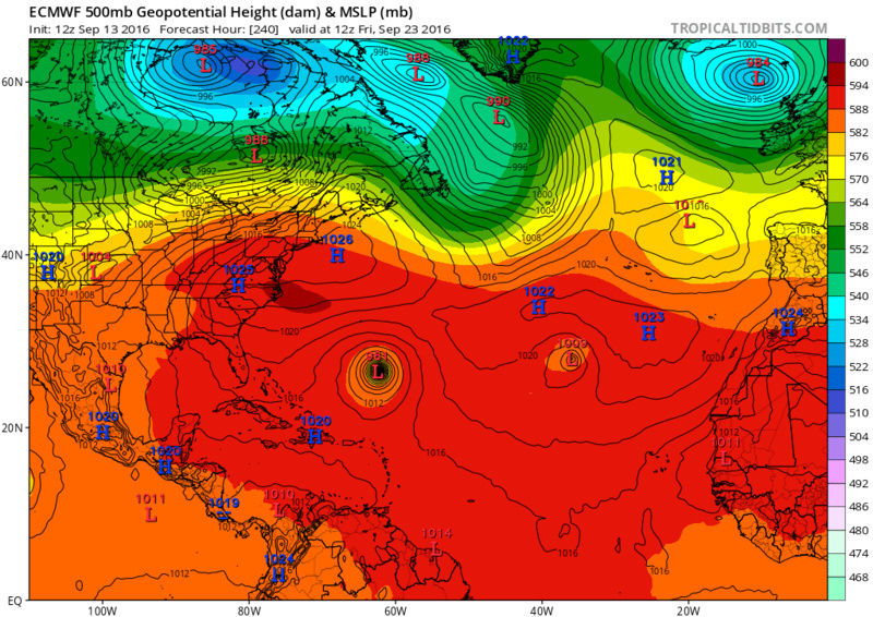
sroc4 wrote:Jman 12L is likely the one that I was hinting at in my above post for the 20th-25th. We shall see how it all shakes out over the next 7-14Days. 12L is just off the screen over the Cape Verde Islands on the Sat loop.
No such thing as 12L, lol just joking around its actually TD 12 now. Year it looks to get to TS then depression then TS and is stays mainly WNW per NHC track.
jmanley32- Senior Enthusiast
- Posts : 20517
Reputation : 108
Join date : 2013-12-12
Age : 42
Location : Yonkers, NY
Re: 2016 Tropical Cyclone Discussions
![]() by jmanley32 Wed Sep 14, 2016 2:05 pm
by jmanley32 Wed Sep 14, 2016 2:05 pm
jmanley32- Senior Enthusiast
- Posts : 20517
Reputation : 108
Join date : 2013-12-12
Age : 42
Location : Yonkers, NY
Re: 2016 Tropical Cyclone Discussions
![]() by NjWeatherGuy Wed Sep 14, 2016 2:15 pm
by NjWeatherGuy Wed Sep 14, 2016 2:15 pm
jmanley32 wrote:Any chance Julia poses a threat to area if she stays as slow as she is and misses front? Hermine wasn't supposed to be a threat to the area and decided to be after crossing FL (well on her lead up to FL). sroc from the Euro image I posted above looks like if that went out further in time there is a escape route to N and then NE, or would it stay under the HP as modeled in that run? If we going to see any more threats its probably going to be very end of September through October, IMO. Been a active season but nothing really monstrous, we still are supposed to see a few more majors but unless conditions improve I do not know if I see that happening.
Dont think so, HP looks to keep it suppressed out of the area and eventually it just stalls off the coast and the energy is picked up/kicked out by front. Dont see enough interaction to pull it up the coast although the models are a bit more robust with the system off the coast today but still well to the south, we just get the front perhaps with a bit of enhancement.
http://collaboration.cmc.ec.gc.ca/cmc/cmdn/pcpn_type/pcpn_type_gem_reg.html
NjWeatherGuy- Advanced Forecaster
- Posts : 4100
Reputation : 28
Join date : 2013-01-06
Location : Belle Mead, NJ
Page 21 of 33 • 1 ... 12 ... 20, 21, 22 ... 27 ... 33 ![]()
|
|
|