
 Search
2016 Tropical Cyclone Discussions
Page 24 of 33 •  1 ... 13 ... 23, 24, 25 ... 28 ... 33
 ![]()
Re: 2016 Tropical Cyclone Discussions
![]() by Guest Wed Sep 21, 2016 12:09 pm
by Guest Wed Sep 21, 2016 12:09 pm
jmanley32 wrote:Gfs still showing a powerful hurricane into fl bend. 2 this yr? Fantasy land but even cmc and euro have the system very far south off africa and part way across atlantic by 240. May b one to watch in a week or so. I'm not sure if it's a pouch over africa right now or not. Karl amazing back to depression. Atlantic is just hostile. But if this storm the models are showing stay that far south and then curve north in similar spot to sandy or irene I think a storm in thst area could maintain.
Why don't we all just chip in and buy you a big industrial fan that you can turn on yourself while you take a shower. This way you can live a hurricane daily.
Guest- Guest
Re: 2016 Tropical Cyclone Discussions
![]() by Snow88 Wed Sep 21, 2016 1:18 pm
by Snow88 Wed Sep 21, 2016 1:18 pm
Snow88- Senior Enthusiast

- Posts : 2193
Join date : 2013-01-09
Re: 2016 Tropical Cyclone Discussions
![]() by jmanley32 Wed Sep 21, 2016 5:52 pm
by jmanley32 Wed Sep 21, 2016 5:52 pm
haha what can I do for blizzards? Gonna have to have a shower of shaved ice lolsyosnow94 wrote:jmanley32 wrote:Gfs still showing a powerful hurricane into fl bend. 2 this yr? Fantasy land but even cmc and euro have the system very far south off africa and part way across atlantic by 240. May b one to watch in a week or so. I'm not sure if it's a pouch over africa right now or not. Karl amazing back to depression. Atlantic is just hostile. But if this storm the models are showing stay that far south and then curve north in similar spot to sandy or irene I think a storm in thst area could maintain.
Why don't we all just chip in and buy you a big industrial fan that you can turn on yourself while you take a shower. This way you can live a hurricane daily.

jmanley32- Senior Enthusiast
- Posts : 20513
Reputation : 108
Join date : 2013-12-12
Age : 42
Location : Yonkers, NY
Re: 2016 Tropical Cyclone Discussions
![]() by Snow88 Thu Sep 22, 2016 8:45 am
by Snow88 Thu Sep 22, 2016 8:45 am
http://www.stormvistawxmodels.com/img/gfs/current/06z/GFS_MSLPThickQPF_na_f348.png?1364096147
http://www.stormvistawxmodels.com/img/gfs/current/06z/GFS_MSLPThickQPF_na_f372.png?1364096147
GFS has been showing this storm for a while now

Snow88- Senior Enthusiast
- Posts : 2193
Reputation : 4
Join date : 2013-01-09
Age : 35
Location : Brooklyn, NY
Re: 2016 Tropical Cyclone Discussions
![]() by jmanley32 Thu Sep 22, 2016 10:08 am
by jmanley32 Thu Sep 22, 2016 10:08 am
jmanley32- Senior Enthusiast
- Posts : 20513
Reputation : 108
Join date : 2013-12-12
Age : 42
Location : Yonkers, NY

jmanley32- Senior Enthusiast
- Posts : 20513
Reputation : 108
Join date : 2013-12-12
Age : 42
Location : Yonkers, NY

jmanley32- Senior Enthusiast
- Posts : 20513
Reputation : 108
Join date : 2013-12-12
Age : 42
Location : Yonkers, NY
Re: 2016 Tropical Cyclone Discussions
![]() by jmanley32 Thu Sep 22, 2016 10:18 am
by jmanley32 Thu Sep 22, 2016 10:18 am
jmanley32- Senior Enthusiast
- Posts : 20513
Reputation : 108
Join date : 2013-12-12
Age : 42
Location : Yonkers, NY
Re: 2016 Tropical Cyclone Discussions
![]() by sroc4 Thu Sep 22, 2016 11:52 am
by sroc4 Thu Sep 22, 2016 11:52 am
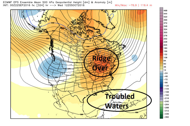

Remember I showed a similar pattern in the LR approx 10-14days ago and yes we have Karl, and Karl in the LR on the surface maps looked all mighty, but look at how that turned out. On the images above in addition to the ridge over troubled waters there is also a trough East of the ridge out in the mid Atlantic, which like whats happening to Karl now may once again lead to a trend towards a swing and a miss wide Right. So we wait and...WE TRACK!!!!
_________________
"In weather and in life, there's no winning and losing; there's only winning and learning."
WINTER 2012/2013 TOTALS 43.65"WINTER 2017/2018 TOTALS 62.85" WINTER 2022/2023 TOTALS 4.9"
WINTER 2013/2014 TOTALS 64.85"WINTER 2018/2019 TOTALS 14.25" WINTER 2023/2024 TOTALS 13.1"
WINTER 2014/2015 TOTALS 71.20"WINTER 2019/2020 TOTALS 6.35"
WINTER 2015/2016 TOTALS 35.00"WINTER 2020/2021 TOTALS 37.75"
WINTER 2016/2017 TOTALS 42.25"WINTER 2021/2022 TOTALS 31.65"

sroc4- Admin

- Posts : 8331
Reputation : 301
Join date : 2013-01-07
Location : Wading River, LI
Re: 2016 Tropical Cyclone Discussions
![]() by jmanley32 Thu Sep 22, 2016 12:57 pm
by jmanley32 Thu Sep 22, 2016 12:57 pm
jmanley32- Senior Enthusiast
- Posts : 20513
Reputation : 108
Join date : 2013-12-12
Age : 42
Location : Yonkers, NY
Re: 2016 Tropical Cyclone Discussions
![]() by jmanley32 Thu Sep 22, 2016 12:59 pm
by jmanley32 Thu Sep 22, 2016 12:59 pm
jmanley32- Senior Enthusiast
- Posts : 20513
Reputation : 108
Join date : 2013-12-12
Age : 42
Location : Yonkers, NY
Re: 2016 Tropical Cyclone Discussions
![]() by sroc4 Thu Sep 22, 2016 1:56 pm
by sroc4 Thu Sep 22, 2016 1:56 pm
jmanley32 wrote:12z cmc hr 240 really? Get ur act together.lol like a dozen lp in Atlantic dnd eastern pacific put together.
lol

_________________
"In weather and in life, there's no winning and losing; there's only winning and learning."
WINTER 2012/2013 TOTALS 43.65"WINTER 2017/2018 TOTALS 62.85" WINTER 2022/2023 TOTALS 4.9"
WINTER 2013/2014 TOTALS 64.85"WINTER 2018/2019 TOTALS 14.25" WINTER 2023/2024 TOTALS 13.1"
WINTER 2014/2015 TOTALS 71.20"WINTER 2019/2020 TOTALS 6.35"
WINTER 2015/2016 TOTALS 35.00"WINTER 2020/2021 TOTALS 37.75"
WINTER 2016/2017 TOTALS 42.25"WINTER 2021/2022 TOTALS 31.65"
sroc4- Admin
- Posts : 8331
Reputation : 301
Join date : 2013-01-07
Location : Wading River, LI
Re: 2016 Tropical Cyclone Discussions
![]() by jmanley32 Thu Sep 22, 2016 2:03 pm
by jmanley32 Thu Sep 22, 2016 2:03 pm

jmanley32- Senior Enthusiast
- Posts : 20513
Reputation : 108
Join date : 2013-12-12
Age : 42
Location : Yonkers, NY
Re: 2016 Tropical Cyclone Discussions
![]() by amugs Thu Sep 22, 2016 2:10 pm
by amugs Thu Sep 22, 2016 2:10 pm
2nd half comeback??? LOTS of time left in this season.
_________________
Mugs
AKA:King: Snow Weenie
Self Proclaimed
WINTER 2014-15 : 55.12" +.02 for 6 coatings (avg. 35")
WINTER 2015-16 Total - 29.8" (Avg 35")
WINTER 2016-17 : 39.5" so far

amugs- Advanced Forecaster - Mod

- Posts : 15093
Reputation : 213
Join date : 2013-01-07
Age : 54
Location : Hillsdale,NJ
Re: 2016 Tropical Cyclone Discussions
![]() by jmanley32 Fri Sep 23, 2016 8:32 am
by jmanley32 Fri Sep 23, 2016 8:32 am
jmanley32- Senior Enthusiast
- Posts : 20513
Reputation : 108
Join date : 2013-12-12
Age : 42
Location : Yonkers, NY
Re: 2016 Tropical Cyclone Discussions
![]() by jmanley32 Fri Sep 23, 2016 12:47 pm
by jmanley32 Fri Sep 23, 2016 12:47 pm
jmanley32- Senior Enthusiast
- Posts : 20513
Reputation : 108
Join date : 2013-12-12
Age : 42
Location : Yonkers, NY
Re: 2016 Tropical Cyclone Discussions
![]() by sroc4 Fri Sep 23, 2016 1:13 pm
by sroc4 Fri Sep 23, 2016 1:13 pm
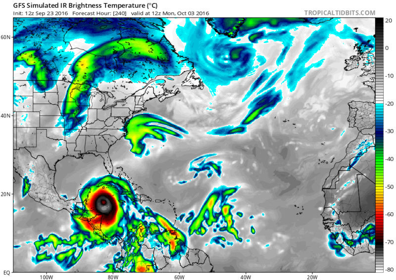
jmanley32 wrote:12z gfs still has storm developing around leeward in 100 hrs or sp then exploding into a huge storm in west central caribbean. By this time does this have a chance to go north or does it look like a gom storm at this time? I think we can really only go out to max of 240 and even then its crap shoot.
Did you look at 500mb? What does it look like?
_________________
"In weather and in life, there's no winning and losing; there's only winning and learning."
WINTER 2012/2013 TOTALS 43.65"WINTER 2017/2018 TOTALS 62.85" WINTER 2022/2023 TOTALS 4.9"
WINTER 2013/2014 TOTALS 64.85"WINTER 2018/2019 TOTALS 14.25" WINTER 2023/2024 TOTALS 13.1"
WINTER 2014/2015 TOTALS 71.20"WINTER 2019/2020 TOTALS 6.35"
WINTER 2015/2016 TOTALS 35.00"WINTER 2020/2021 TOTALS 37.75"
WINTER 2016/2017 TOTALS 42.25"WINTER 2021/2022 TOTALS 31.65"
sroc4- Admin
- Posts : 8331
Reputation : 301
Join date : 2013-01-07
Location : Wading River, LI
Re: 2016 Tropical Cyclone Discussions
![]() by jmanley32 Fri Sep 23, 2016 1:31 pm
by jmanley32 Fri Sep 23, 2016 1:31 pm
sroc4 wrote:jmanley32 wrote:12z gfs still has storm developing around leeward in 100 hrs or sp then exploding into a huge storm in west central caribbean. By this time does this have a chance to go north or does it look like a gom storm at this time? I think we can really only go out to max of 240 and even then its crap shoot.
Did you look at 500mb? What does it look like?
The GFS has it go across Yucatan so something keeps it well south, I have a hard time understanding the 500mb, I know yes I have been here a long time but the way I learn I really need someone to sit down with me explain draw etc. My ability to read and apply is difficult. I think this def poses a threat per the models to someone, lets say for now the islands because after that we are pushing truncation. BTW look at this! If this turns north FL and EC are in deep s##t, IF it verified, which after the models this year blowing everything up. But one thing noted by models and other boards agreeing the Euro and GFS all deepen this to a very strong storm, the GFS much more, I think the low of 12z was 904mb?
jmanley32- Senior Enthusiast
- Posts : 20513
Reputation : 108
Join date : 2013-12-12
Age : 42
Location : Yonkers, NY
Re: 2016 Tropical Cyclone Discussions
![]() by jmanley32 Fri Sep 23, 2016 1:40 pm
by jmanley32 Fri Sep 23, 2016 1:40 pm
jmanley32- Senior Enthusiast
- Posts : 20513
Reputation : 108
Join date : 2013-12-12
Age : 42
Location : Yonkers, NY
Re: 2016 Tropical Cyclone Discussions
![]() by sroc4 Fri Sep 23, 2016 2:04 pm
by sroc4 Fri Sep 23, 2016 2:04 pm

_________________
"In weather and in life, there's no winning and losing; there's only winning and learning."
WINTER 2012/2013 TOTALS 43.65"WINTER 2017/2018 TOTALS 62.85" WINTER 2022/2023 TOTALS 4.9"
WINTER 2013/2014 TOTALS 64.85"WINTER 2018/2019 TOTALS 14.25" WINTER 2023/2024 TOTALS 13.1"
WINTER 2014/2015 TOTALS 71.20"WINTER 2019/2020 TOTALS 6.35"
WINTER 2015/2016 TOTALS 35.00"WINTER 2020/2021 TOTALS 37.75"
WINTER 2016/2017 TOTALS 42.25"WINTER 2021/2022 TOTALS 31.65"
sroc4- Admin
- Posts : 8331
Reputation : 301
Join date : 2013-01-07
Location : Wading River, LI
Re: 2016 Tropical Cyclone Discussions
![]() by jmanley32 Fri Sep 23, 2016 2:11 pm
by jmanley32 Fri Sep 23, 2016 2:11 pm
sroc4 wrote:Honestly 240+ hrs out the area circled is the area that is still in play with this system. We have had surface solns up into New England to now staying south into the potential Yucatan Peninsula and inbetween. I personally wouldn't even begin to try and figure out what specific area should watch out until we reach 60W. That is the magic Longitude.
Which is in about 5 days per the models, so just sit and wait and see I guess, yeah love the circle lol., might as well include California too. JK
jmanley32- Senior Enthusiast
- Posts : 20513
Reputation : 108
Join date : 2013-12-12
Age : 42
Location : Yonkers, NY
Re: 2016 Tropical Cyclone Discussions
![]() by jmanley32 Fri Sep 23, 2016 2:50 pm
by jmanley32 Fri Sep 23, 2016 2:50 pm
jmanley32- Senior Enthusiast
- Posts : 20513
Reputation : 108
Join date : 2013-12-12
Age : 42
Location : Yonkers, NY
Re: 2016 Tropical Cyclone Discussions
![]() by jmanley32 Fri Sep 23, 2016 8:45 pm
by jmanley32 Fri Sep 23, 2016 8:45 pm
jmanley32- Senior Enthusiast
- Posts : 20513
Reputation : 108
Join date : 2013-12-12
Age : 42
Location : Yonkers, NY
Re: 2016 Tropical Cyclone Discussions
![]() by amugs Fri Sep 23, 2016 10:06 pm
by amugs Fri Sep 23, 2016 10:06 pm

_________________
Mugs
AKA:King: Snow Weenie
Self Proclaimed
WINTER 2014-15 : 55.12" +.02 for 6 coatings (avg. 35")
WINTER 2015-16 Total - 29.8" (Avg 35")
WINTER 2016-17 : 39.5" so far
amugs- Advanced Forecaster - Mod
- Posts : 15093
Reputation : 213
Join date : 2013-01-07
Age : 54
Location : Hillsdale,NJ
Re: 2016 Tropical Cyclone Discussions
![]() by NjWeatherGuy Fri Sep 23, 2016 10:08 pm
by NjWeatherGuy Fri Sep 23, 2016 10:08 pm
jmanley32 wrote:18z GFS, fantasyland to the MAX
950mb hitting LA, sure they dont need the rain or a hurricane that intense. Luckily for them its the GFS in the long range so it probably wont verify, but I see the CMC going in the same direction before the run cuts off which is a bit concerning.

NjWeatherGuy- Advanced Forecaster

- Posts : 4100
Reputation : 28
Join date : 2013-01-06
Location : Belle Mead, NJ
Re: 2016 Tropical Cyclone Discussions
![]() by Snow88 Sat Sep 24, 2016 12:56 am
by Snow88 Sat Sep 24, 2016 12:56 am
Snow88- Senior Enthusiast
- Posts : 2193
Reputation : 4
Join date : 2013-01-09
Age : 35
Location : Brooklyn, NY
Re: 2016 Tropical Cyclone Discussions
![]() by jmanley32 Sat Sep 24, 2016 1:22 am
by jmanley32 Sat Sep 24, 2016 1:22 am
jmanley32- Senior Enthusiast
- Posts : 20513
Reputation : 108
Join date : 2013-12-12
Age : 42
Location : Yonkers, NY
Page 24 of 33 • 1 ... 13 ... 23, 24, 25 ... 28 ... 33 ![]()
|
|
|