
 Search
2016 Tropical Cyclone Discussions
Page 23 of 33 •  1 ... 13 ... 22, 23, 24 ... 28 ... 33
 ![]()
Re: 2016 Tropical Cyclone Discussions
![]() by jmanley32 Thu Sep 15, 2016 11:11 pm
by jmanley32 Thu Sep 15, 2016 11:11 pm

jmanley32- Senior Enthusiast

- Posts : 20516
Join date : 2013-12-12
Re: 2016 Tropical Cyclone Discussions
![]() by jmanley32 Fri Sep 16, 2016 5:17 am
by jmanley32 Fri Sep 16, 2016 5:17 am
jmanley32- Senior Enthusiast
- Posts : 20516
Join date : 2013-12-12
Re: 2016 Tropical Cyclone Discussions
![]() by sroc4 Fri Sep 16, 2016 7:02 am
by sroc4 Fri Sep 16, 2016 7:02 am
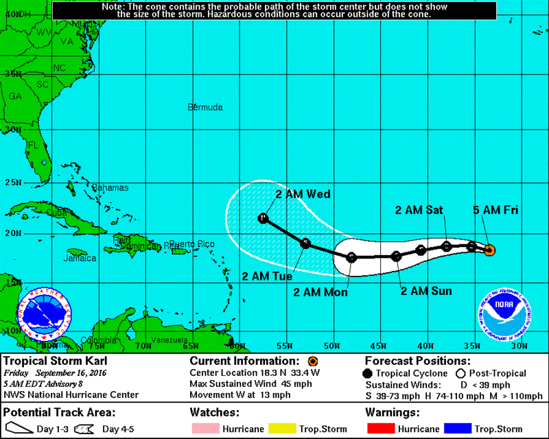
jmanley32 wrote:Wow euro and nav gem and even cmc keep idea of a monstrous storm. cat 4 or so on euro and euro crushed Bermuda with a recurve on ooz. Still plenty of time but I think this one is worthy of its own thread now that it's karl.
Jman lets give this one a few more days before it gets its own thread. As of now a recurve is favored based on the EPS and GEFS ensemble forecasts.


However, just look at how big the cone of uncertainty is in the 3-5day. Where Karl is in the 3-5day and how strong he is at that time will play a key role once he moves beyond 60W. Take a look at the NHC track forecast from this morning(first image) compared to yesterday morning(second image). Notice how yesterdays forecast was to keep it a depression until Monday; whereas it has already developed into a named system. So in theory its 3days ahead of schedule. The general rule is the stronger it is when it reaches 60W and beyond the stronger likelihood it recurves esp with the way the 500mb pattern is currently being modeled. But as we know the further out in time the greater the margin for error. Sooooo......WE TRACK!!


_________________
"In weather and in life, there's no winning and losing; there's only winning and learning."
WINTER 2012/2013 TOTALS 43.65"WINTER 2017/2018 TOTALS 62.85" WINTER 2022/2023 TOTALS 4.9"
WINTER 2013/2014 TOTALS 64.85"WINTER 2018/2019 TOTALS 14.25" WINTER 2023/2024 TOTALS 13.1"
WINTER 2014/2015 TOTALS 71.20"WINTER 2019/2020 TOTALS 6.35"
WINTER 2015/2016 TOTALS 35.00"WINTER 2020/2021 TOTALS 37.75"
WINTER 2016/2017 TOTALS 42.25"WINTER 2021/2022 TOTALS 31.65"

sroc4- Admin

- Posts : 8331
Reputation : 301
Join date : 2013-01-07
Location : Wading River, LI
Re: 2016 Tropical Cyclone Discussions
![]() by sroc4 Fri Sep 16, 2016 9:05 am
by sroc4 Fri Sep 16, 2016 9:05 am
https://m.youtube.com/watch?v=IXergfDWg9o
_________________
"In weather and in life, there's no winning and losing; there's only winning and learning."
WINTER 2012/2013 TOTALS 43.65"WINTER 2017/2018 TOTALS 62.85" WINTER 2022/2023 TOTALS 4.9"
WINTER 2013/2014 TOTALS 64.85"WINTER 2018/2019 TOTALS 14.25" WINTER 2023/2024 TOTALS 13.1"
WINTER 2014/2015 TOTALS 71.20"WINTER 2019/2020 TOTALS 6.35"
WINTER 2015/2016 TOTALS 35.00"WINTER 2020/2021 TOTALS 37.75"
WINTER 2016/2017 TOTALS 42.25"WINTER 2021/2022 TOTALS 31.65"
sroc4- Admin
- Posts : 8331
Reputation : 301
Join date : 2013-01-07
Location : Wading River, LI
Re: 2016 Tropical Cyclone Discussions
![]() by jmanley32 Fri Sep 16, 2016 9:13 am
by jmanley32 Fri Sep 16, 2016 9:13 am
sroc4 wrote:Wowzer!
https://m.youtube.com/watch?v=IXergfDWg9o
Goodammn!!! What are those 400 foot wave crashes, and wow, truck back falling like they are tin cans, that's crazy.

jmanley32- Senior Enthusiast
- Posts : 20516
Reputation : 108
Join date : 2013-12-12
Age : 42
Location : Yonkers, NY
Re: 2016 Tropical Cyclone Discussions
![]() by jmanley32 Fri Sep 16, 2016 9:17 am
by jmanley32 Fri Sep 16, 2016 9:17 am
sroc4 wrote:jmanley32 wrote:Wow euro and nav gem and even cmc keep idea of a monstrous storm. cat 4 or so on euro and euro crushed Bermuda with a recurve on ooz. Still plenty of time but I think this one is worthy of its own thread now that it's karl.
Jman lets give this one a few more days before it gets its own thread. As of now a recurve is favored based on the EPS and GEFS ensemble forecasts.
However, just look at how big the cone of uncertainty is in the 3-5day. Where Karl is in the 3-5day and how strong he is at that time will play a key role once he moves beyond 60W. Take a look at the NHC track forecast from this morning(first image) compared to yesterday morning(second image). Notice how yesterdays forecast was to keep it a depression until Monday; whereas it has already developed into a named system. So in theory its 3days ahead of schedule. The general rule is the stronger it is when it reaches 60W and beyond the stronger likelihood it recurves esp with the way the 500mb pattern is currently being modeled. But as we know the further out in time the greater the margin for error. Sooooo......WE TRACK!!
Well even if it is a recurve (not out of the question it could threaten the EC, and if the Euro is at all correct god help us all) from what models are hinting in intensity (now hurricane by Wed, wouldn't be surprised if well before) this may be one we want to archive just for it being a possibly big amazing looking storm, but I can see waiting a bit longer. Just figured we are gonna have many storms to discuss in the coming weeks as African wave train looks busy and separate threads is easier. Oh BTW Someone I read on another board found old forecasts from Gloria who had a similar projection to recurve well away from the US, so you just never really know. Also note the western most Euro ensembles are close enough to bring at least coastal impacts if not landfalls and some do show cat 2+ landfalls, albeit not many. Those sgetti just do not go out far enough.
jmanley32- Senior Enthusiast
- Posts : 20516
Reputation : 108
Join date : 2013-12-12
Age : 42
Location : Yonkers, NY
Re: 2016 Tropical Cyclone Discussions
![]() by jmanley32 Fri Sep 16, 2016 9:20 am
by jmanley32 Fri Sep 16, 2016 9:20 am
jmanley32- Senior Enthusiast
- Posts : 20516
Reputation : 108
Join date : 2013-12-12
Age : 42
Location : Yonkers, NY
Re: 2016 Tropical Cyclone Discussions
![]() by jmanley32 Fri Sep 16, 2016 9:22 am
by jmanley32 Fri Sep 16, 2016 9:22 am
http://www.ssd.noaa.gov/PS/TROP/floaters/12L/imagery/rgb-animated.gif
jmanley32- Senior Enthusiast
- Posts : 20516
Reputation : 108
Join date : 2013-12-12
Age : 42
Location : Yonkers, NY
Re: 2016 Tropical Cyclone Discussions
![]() by sroc4 Fri Sep 16, 2016 9:25 am
by sroc4 Fri Sep 16, 2016 9:25 am
_________________
"In weather and in life, there's no winning and losing; there's only winning and learning."
WINTER 2012/2013 TOTALS 43.65"WINTER 2017/2018 TOTALS 62.85" WINTER 2022/2023 TOTALS 4.9"
WINTER 2013/2014 TOTALS 64.85"WINTER 2018/2019 TOTALS 14.25" WINTER 2023/2024 TOTALS 13.1"
WINTER 2014/2015 TOTALS 71.20"WINTER 2019/2020 TOTALS 6.35"
WINTER 2015/2016 TOTALS 35.00"WINTER 2020/2021 TOTALS 37.75"
WINTER 2016/2017 TOTALS 42.25"WINTER 2021/2022 TOTALS 31.65"
sroc4- Admin
- Posts : 8331
Reputation : 301
Join date : 2013-01-07
Location : Wading River, LI
Re: 2016 Tropical Cyclone Discussions
![]() by jmanley32 Fri Sep 16, 2016 9:32 am
by jmanley32 Fri Sep 16, 2016 9:32 am
sroc4 wrote:JMan let me be clear. I am not calling for a recurve OR an EC landfall. Absolutely an EC landfall is possible. We have seen time and time again the LR 500mb pattern change over and over. But it's 10days away. My point really is that within the last 24hrs the forecast for Karl has changed drastically so no sense in getting too worked up on something One way or the other when it's likely to change multiple times between now and then.
Yes agreed, it does look like it stands a decent chance to get pretty reved up though but we shall see, and ya a lot of changes in only 2 days. If you did not see the euro control run check it out, its a little "loopy" lol hint
jmanley32- Senior Enthusiast
- Posts : 20516
Reputation : 108
Join date : 2013-12-12
Age : 42
Location : Yonkers, NY
Re: 2016 Tropical Cyclone Discussions
![]() by Snow88 Fri Sep 16, 2016 1:10 pm
by Snow88 Fri Sep 16, 2016 1:10 pm

Snow88- Senior Enthusiast
- Posts : 2193
Reputation : 4
Join date : 2013-01-09
Age : 35
Location : Brooklyn, NY
Re: 2016 Tropical Cyclone Discussions
![]() by jmanley32 Fri Sep 16, 2016 6:52 pm
by jmanley32 Fri Sep 16, 2016 6:52 pm
jmanley32- Senior Enthusiast
- Posts : 20516
Reputation : 108
Join date : 2013-12-12
Age : 42
Location : Yonkers, NY
Re: 2016 Tropical Cyclone Discussions
![]() by Snow88 Sat Sep 17, 2016 12:49 am
by Snow88 Sat Sep 17, 2016 12:49 am
Snow88- Senior Enthusiast
- Posts : 2193
Reputation : 4
Join date : 2013-01-09
Age : 35
Location : Brooklyn, NY
Re: 2016 Tropical Cyclone Discussions
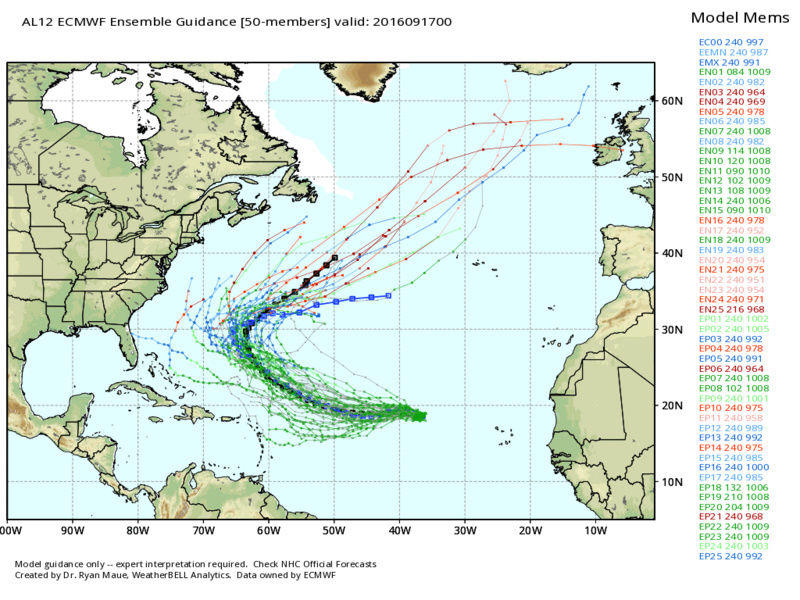
![]() by sroc4 Sat Sep 17, 2016 7:27 am
by sroc4 Sat Sep 17, 2016 7:27 am


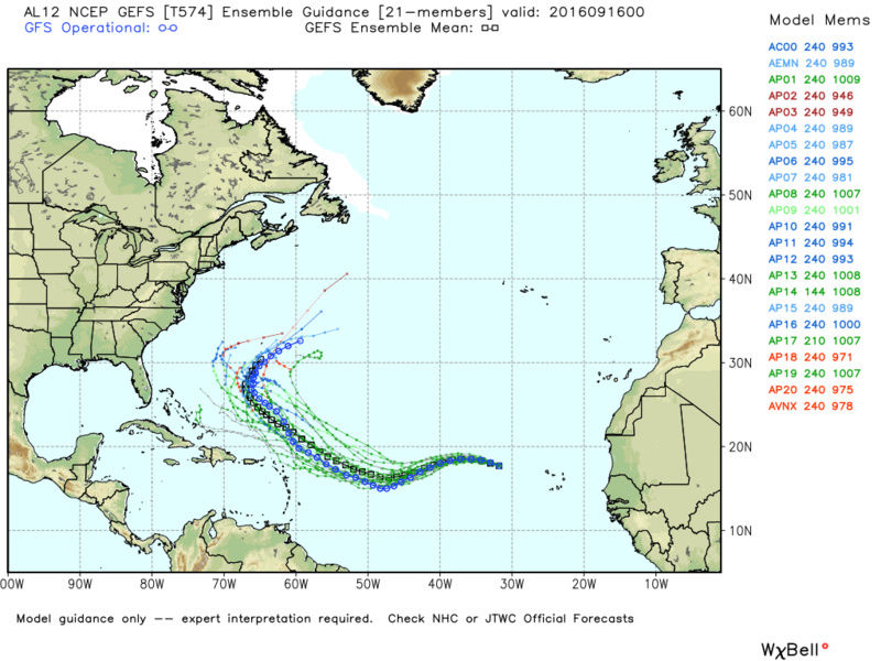
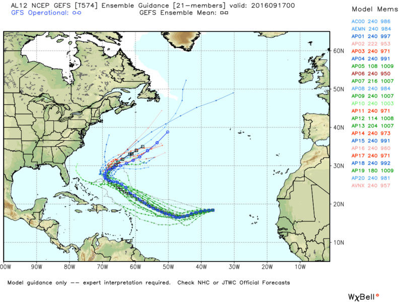
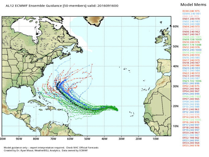
Yesterdays 00z ensemble forecasts vs this mornings. GEFS then EPS:
_________________
"In weather and in life, there's no winning and losing; there's only winning and learning."
WINTER 2012/2013 TOTALS 43.65"WINTER 2017/2018 TOTALS 62.85" WINTER 2022/2023 TOTALS 4.9"
WINTER 2013/2014 TOTALS 64.85"WINTER 2018/2019 TOTALS 14.25" WINTER 2023/2024 TOTALS 13.1"
WINTER 2014/2015 TOTALS 71.20"WINTER 2019/2020 TOTALS 6.35"
WINTER 2015/2016 TOTALS 35.00"WINTER 2020/2021 TOTALS 37.75"
WINTER 2016/2017 TOTALS 42.25"WINTER 2021/2022 TOTALS 31.65"
sroc4- Admin
- Posts : 8331
Reputation : 301
Join date : 2013-01-07
Location : Wading River, LI
Re: 2016 Tropical Cyclone Discussions
![]() by Snow88 Sat Sep 17, 2016 1:22 pm
by Snow88 Sat Sep 17, 2016 1:22 pm
Snow88- Senior Enthusiast
- Posts : 2193
Reputation : 4
Join date : 2013-01-09
Age : 35
Location : Brooklyn, NY
Re: 2016 Tropical Cyclone Discussions
![]() by amugs Sat Sep 17, 2016 1:29 pm
by amugs Sat Sep 17, 2016 1:29 pm
Snow88 wrote:GFS is more west than the past run and weaker. Still a fish storm.
If it misses the trough in SE CAN and over teh North Atlantic then it can come more west. Only time will tell.
_________________
Mugs
AKA:King: Snow Weenie
Self Proclaimed
WINTER 2014-15 : 55.12" +.02 for 6 coatings (avg. 35")
WINTER 2015-16 Total - 29.8" (Avg 35")
WINTER 2016-17 : 39.5" so far

amugs- Advanced Forecaster - Mod

- Posts : 15093
Reputation : 213
Join date : 2013-01-07
Age : 54
Location : Hillsdale,NJ
Re: 2016 Tropical Cyclone Discussions
![]() by jmanley32 Sat Sep 17, 2016 3:36 pm
by jmanley32 Sat Sep 17, 2016 3:36 pm
jmanley32- Senior Enthusiast
- Posts : 20516
Reputation : 108
Join date : 2013-12-12
Age : 42
Location : Yonkers, NY
Re: 2016 Tropical Cyclone Discussions
![]() by amugs Sat Sep 17, 2016 3:58 pm
by amugs Sat Sep 17, 2016 3:58 pm
 b
b_________________
Mugs
AKA:King: Snow Weenie
Self Proclaimed
WINTER 2014-15 : 55.12" +.02 for 6 coatings (avg. 35")
WINTER 2015-16 Total - 29.8" (Avg 35")
WINTER 2016-17 : 39.5" so far
amugs- Advanced Forecaster - Mod
- Posts : 15093
Reputation : 213
Join date : 2013-01-07
Age : 54
Location : Hillsdale,NJ
Re: 2016 Tropical Cyclone Discussions
![]() by jmanley32 Sat Sep 17, 2016 7:28 pm
by jmanley32 Sat Sep 17, 2016 7:28 pm
jmanley32- Senior Enthusiast
- Posts : 20516
Reputation : 108
Join date : 2013-12-12
Age : 42
Location : Yonkers, NY
Re: 2016 Tropical Cyclone Discussions
![]() by Snow88 Mon Sep 19, 2016 3:08 pm
by Snow88 Mon Sep 19, 2016 3:08 pm
Boring tropical season continues
Snow88- Senior Enthusiast
- Posts : 2193
Reputation : 4
Join date : 2013-01-09
Age : 35
Location : Brooklyn, NY
Re: 2016 Tropical Cyclone Discussions
![]() by amugs Mon Sep 19, 2016 3:40 pm
by amugs Mon Sep 19, 2016 3:40 pm
Snow88 wrote:Karl looks OTS
Boring tropical season continues
To a degree but ain't over by a long shot IMO - we have about 3 more Trop Waves to watch and the further south they are the more west they get - this season goes until late October maybe early Nov at this point.
_________________
Mugs
AKA:King: Snow Weenie
Self Proclaimed
WINTER 2014-15 : 55.12" +.02 for 6 coatings (avg. 35")
WINTER 2015-16 Total - 29.8" (Avg 35")
WINTER 2016-17 : 39.5" so far
amugs- Advanced Forecaster - Mod
- Posts : 15093
Reputation : 213
Join date : 2013-01-07
Age : 54
Location : Hillsdale,NJ
Re: 2016 Tropical Cyclone Discussions
![]() by Snow88 Tue Sep 20, 2016 1:40 pm
by Snow88 Tue Sep 20, 2016 1:40 pm
Snow88- Senior Enthusiast
- Posts : 2193
Reputation : 4
Join date : 2013-01-09
Age : 35
Location : Brooklyn, NY
Re: 2016 Tropical Cyclone Discussions
![]() by jmanley32 Tue Sep 20, 2016 2:41 pm
by jmanley32 Tue Sep 20, 2016 2:41 pm
jmanley32- Senior Enthusiast
- Posts : 20516
Reputation : 108
Join date : 2013-12-12
Age : 42
Location : Yonkers, NY
Re: 2016 Tropical Cyclone Discussions
![]() by Snow88 Tue Sep 20, 2016 3:16 pm
by Snow88 Tue Sep 20, 2016 3:16 pm
Yep, Sandy and Irene did that.jmanley32 wrote:saw that snow, if you follow closely its actually a cabo verde storm that's at a VERY low latitude and comes up to head into FL or up EC, those storms tend to be our biggest threat. I believe Irene & Sandy did something similar to this at their starting point. Shoot but we are just chopping away at the names but nothing of real significance yet. Something tells me this season may go out with a bang in mid to late October. We have already surpassed the low end of named storms but not in terms of hurricane or majors, did we even have a major yet?
Snow88- Senior Enthusiast
- Posts : 2193
Reputation : 4
Join date : 2013-01-09
Age : 35
Location : Brooklyn, NY
Re: 2016 Tropical Cyclone Discussions
![]() by jmanley32 Wed Sep 21, 2016 11:31 am
by jmanley32 Wed Sep 21, 2016 11:31 am
jmanley32- Senior Enthusiast
- Posts : 20516
Reputation : 108
Join date : 2013-12-12
Age : 42
Location : Yonkers, NY
Re: 2016 Tropical Cyclone Discussions
![]() by Guest Wed Sep 21, 2016 12:09 pm
by Guest Wed Sep 21, 2016 12:09 pm
jmanley32 wrote:Gfs still showing a powerful hurricane into fl bend. 2 this yr? Fantasy land but even cmc and euro have the system very far south off africa and part way across atlantic by 240. May b one to watch in a week or so. I'm not sure if it's a pouch over africa right now or not. Karl amazing back to depression. Atlantic is just hostile. But if this storm the models are showing stay that far south and then curve north in similar spot to sandy or irene I think a storm in thst area could maintain.
Why don't we all just chip in and buy you a big industrial fan that you can turn on yourself while you take a shower. This way you can live a hurricane daily.
Guest- Guest
Re: 2016 Tropical Cyclone Discussions
![]() by Snow88 Wed Sep 21, 2016 1:18 pm
by Snow88 Wed Sep 21, 2016 1:18 pm
Snow88- Senior Enthusiast
- Posts : 2193
Reputation : 4
Join date : 2013-01-09
Age : 35
Location : Brooklyn, NY
Page 23 of 33 • 1 ... 13 ... 22, 23, 24 ... 28 ... 33 ![]()
|
|
|