
 Search
Hurricane Hermine Discussion Part 2
Page 25 of 35 •  1 ... 14 ... 24, 25, 26 ... 30 ... 35
 ![]()
Re: Hurricane Hermine Discussion Part 2
![]() by skinsfan1177 Sun Sep 04, 2016 6:57 am
by skinsfan1177 Sun Sep 04, 2016 6:57 am
skinsfan1177- Senior Enthusiast

- Posts : 4485
Join date : 2013-01-07
Re: Hurricane Hermine Discussion Part 2
![]() by skinsfan1177 Sun Sep 04, 2016 7:09 am
by skinsfan1177 Sun Sep 04, 2016 7:09 am
skinsfan1177- Senior Enthusiast
- Posts : 4485
Join date : 2013-01-07
Re: Hurricane Hermine Discussion Part 2
![]() by Radz Sun Sep 04, 2016 7:33 am
by Radz Sun Sep 04, 2016 7:33 am
NjWeatherGuy wrote:Current SLP location and radar (where covered)
http://www.spc.noaa.gov/exper/mesoanalysis/new/viewsector.php?sector=16
Doesn't look very impressive and I don't like to toot my own horn but it looks like it's escaping east and is weak. Especially because I wanted a little action (ex. wind and especially rain, we could use it), but it's not gonna happen. I actually am feeling confident at this point about that given the look.
Gotta give credit where credit is due, I don't see how this would turn and make a run at the coast at this juncture, it looks way further east than expected, think you were spot on with your gut feeling and analysis, a few more hours and i think you can toot away

Radz- Pro Enthusiast

- Posts : 1028
Reputation : 17
Join date : 2013-01-12
Location : Cortlandt Manor NY
Re: Hurricane Hermine Discussion Part 2
![]() by Guest Sun Sep 04, 2016 7:38 am
by Guest Sun Sep 04, 2016 7:38 am
Guest- Guest
Re: Hurricane Hermine Discussion Part 2
![]() by weatherwatchermom Sun Sep 04, 2016 7:48 am
by weatherwatchermom Sun Sep 04, 2016 7:48 am

weatherwatchermom- Senior Enthusiast
- Posts : 3750
Reputation : 77
Join date : 2014-11-25
Age : 60
Location : Hazlet Township, NJ
Re: Hurricane Hermine Discussion Part 2
![]() by Radz Sun Sep 04, 2016 7:53 am
by Radz Sun Sep 04, 2016 7:53 am
Radz- Pro Enthusiast
- Posts : 1028
Reputation : 17
Join date : 2013-01-12
Location : Cortlandt Manor NY
Re: Hurricane Hermine Discussion Part 2
![]() by Joe Snow Sun Sep 04, 2016 7:53 am
by Joe Snow Sun Sep 04, 2016 7:53 am

Joe Snow- Pro Enthusiast
- Posts : 924
Reputation : 7
Join date : 2014-02-12
Age : 62
Location : Sanford Florida, Fmrly Kings Park, NY
Re: Hurricane Hermine Discussion Part 2
![]() by billg315 Sun Sep 04, 2016 7:58 am
by billg315 Sun Sep 04, 2016 7:58 am

billg315- Advanced Forecaster - Mod

- Posts : 4469
Reputation : 185
Join date : 2015-01-24
Age : 50
Location : Flemington, NJ
Re: Hurricane Hermine Discussion Part 2
![]() by Frank_Wx Sun Sep 04, 2016 8:00 am
by Frank_Wx Sun Sep 04, 2016 8:00 am

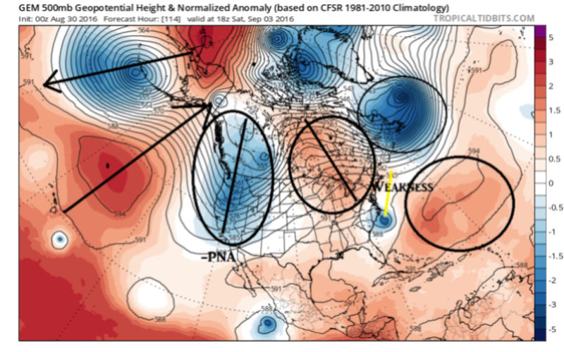
Here is a look at 500mb heights at initialization of the GFS. The High is northwest of Hermine near the Lakes, she's very weak, and there is a positive NAO.. Eventually the ridge will build in from the east and trap Hermine, which is why she'll end up off the coast for a few days.
I think the biggest let down (for some people) is Hermine will remain very weak when guidance showed her intensifying again. Also, it's very clear the blocking pattern was not established quick enough which is why Hermine is sliding east at this time. By the time the block is established she will be too far east and a retrograde west won't be enough to cause major impacts.
This ended up working out for the Sandy riddled areas who couldn't afford another storm. If Herminea retrograde came to fruition there would have been trouble.
That said, forecasts are still showing a 4 foot surge along the NJ shore and 5 foot north of LI and CT. And that'd with the latest model runs. Do what you have to do to combat the surge if you live in that area. It's going to be like that for 2-3 days. Winds at Tropical Storm force are still on the table too. Rain will be very minimal.
No change to my forecast (click on scroll if you did not read it yesterday)
Hey, at least we can salvage most of this holiday weekend!! Have a good day.

_________________
_______________________________________________________________________________________________________
CLICK HERE to view NJ Strong Snowstorm Classifications

Frank_Wx- Godzilla Seeker

- Posts : 21305
Reputation : 328
Join date : 2013-01-05
Age : 31
Location : Jersey City, NJ -

Re: Hurricane Hermine Discussion Part 2
![]() by sroc4 Sun Sep 04, 2016 8:02 am
by sroc4 Sun Sep 04, 2016 8:02 am
skinsfan1177 wrote:It would be great for analysis of what went wrong
Its actually pretty simple Skins. Bottom line is the lifting trough into the NW Atlantic pulled it too far east and therefore the timing of the system cutting itself off from the main westerly flow is too late. There will likely still be a north and maybe even a NW movement but it will be more of a meandering movement like the spinning of a top analogy I gave a few morning ago. This was never going to be a full "capture" and pull it hard left like Sandy was. The approaching trough in the west would have needed to phase with and go negative. There is simply no NAO blocking for that. The blocking that we have been talking about was simply a strong HP going up in the wake of the exiting s/w trough. It just didn't happen quick enough. This was the write up from the 30th and 31st. Again I think its as simple as it hasn't cut itself off from the the exiting trough and ended up being pulled topo far east as a result.
AUG 30th:
Jman and others...the OTS soln occurs because the trough that digs into the east and picks up TD 9 and turns it north into the big bend area of Fla

then carries it OTS in the progressive flow because the trough axis is positively tilted (SW to NE). The Euro shows this nicely.


The CMC on the other hand does not dig this trough as deep, is a little faster with the trough, and TD 9 comes off the SE coast further S relative to the euro, so the system as a whole misses the trough. Initially the trough digs deep enough to steer in N and NE but doesn't dig enough to fully capture it; so it lifts out leaving the system behind. The next trough coming in begins to tug at it back towards the coast.


Like Snow mentions above there are ensemble members in both GFS and Euro camps to support this. We will have to se how the models trend over the next 48-72hrs regarding the timing and how deep the trough actually is. Very complex set up. The euro soln from the other day shows a trough split. Meaning the main energy with TD 9 gets pulled OTS with the main trough but a piece of it breaks off and hangs back along an old frontal boundary left behind then retrogrades back towards the SE coast with some tropical development possible. Nothing about 99L to TD 9 has been been routine, and none of the models have had a true handle on this wave consistently at all. Bottom line....
WE TRACK!!!
AUG31st
Hey Rb. Let me start by saying I prev thought and still believe that ultimately this will swing and miss most if not all of the NE, but a few points to be made. First is that the models have been in fair agreement, GFS, Euro operationals and their ensembles, that the main energy from TD 9 will be left behind at some point from the trough. I do believe that a retrograde towards the coast is def possible. Not however in a Sandy esque fashion where we get a phase with the trough and a full neg tilt etc, but rather IF, and its a big IF, the timing of the system with the trough is off it gets left behind cutoff from the main flow. Afterall it is a tropical system; not a run of the mill LP off the coast. Although the -NAO blocking is not present its actually the -PNA that sets this potential up. Here is the 500mb anomalies from the CMC showing my points:
First frame: Trough digging S of Aleutians building ridge into GOA consequently digging trough ito the west coast (-PNA) which argues for Ridging along the east coast.
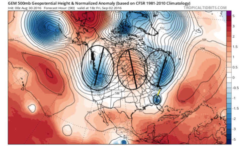
Therefore the trough that digs into the EC tugging our little fiend TD 9 North has NO staying power; is progressive (as seen by extreme positive tilt) and so lifts up and out into the N Atlantic very quickly. See next fram below. In its wake HP will want to build; however there is a weakness that our system heads for left behind in between the Sub tropical ridge and the ridge over the N CONUS/E Canada
HOWEVER, The CMC soln from 24hrs ago the ridge builds in rapidly in the wake of the exiting trough and in front of the system effectively cutting it off from the main flow and trapping/blocking its exit.

This is in fact in response to the -PNA establishing itself. Strong trough in the west ridge response in the east. Result is a system that gets turned back towards the coast in response to the approaching trough

Now lets be clear here....TIMING IS EVERYTHING. TD 9 still would likely still need to slow down some from its current forecast in order to miss the trough and leave it close enough to the coast to have it retrograde enough to have an impact in the NE. That said, and I mentioned above, there is good agreement for now, that it will in fact be left behind and be cutoff from the main westerly's for a brief time until the next trough picks it up and officially takes it away into the N Atlantic. And there looks to be a gentle turn back N and/or NW as it feels the approaching trough before its swept away. Timing will be key here. Remember models have been doing a poor job overall beyond day 3 so take it all with a grain of salt and keep monitoring for trends.
_________________
"In weather and in life, there's no winning and losing; there's only winning and learning."
WINTER 2012/2013 TOTALS 43.65"WINTER 2017/2018 TOTALS 62.85" WINTER 2022/2023 TOTALS 4.9"
WINTER 2013/2014 TOTALS 64.85"WINTER 2018/2019 TOTALS 14.25" WINTER 2023/2024 TOTALS 13.1"
WINTER 2014/2015 TOTALS 71.20"WINTER 2019/2020 TOTALS 6.35"
WINTER 2015/2016 TOTALS 35.00"WINTER 2020/2021 TOTALS 37.75"
WINTER 2016/2017 TOTALS 42.25"WINTER 2021/2022 TOTALS 31.65"

sroc4- Admin
- Posts : 8331
Reputation : 301
Join date : 2013-01-07
Location : Wading River, LI
Re: Hurricane Hermine Discussion Part 2
![]() by weatherwatchermom Sun Sep 04, 2016 8:06 am
by weatherwatchermom Sun Sep 04, 2016 8:06 am
Frank_Wx wrote:
Here is a look at 500mb heights at initialization of the GFS. The High is northwest of Hermine near the Lakes, she's very weak, and there is a positive NAO.. Eventually the ridge will build in from the east and trap Hermine, which is why she'll end up off the coast for a few days.
I think the biggest let down (for some people) is Hermine will remain very weak when guidance showed her intensifying again. Also, it's very clear the blocking pattern was not established quick enough which is why Hermine is sliding east at this time. By the time the block is established she will be too far east and a retrograde west won't be enough to cause major impacts.
This ended up working out for the Sandy riddled areas who couldn't afford another storm. If Herminea retrograde came to fruition there would have been trouble.
That said, forecasts are still showing a 4 foot surge along the NJ shore and 5 foot north of LI and CT. And that'd with the latest model runs. Do what you have to do to combat the surge if you live in that area. It's going to be like that for 2-3 days. Winds at Tropical Storm force are still on the table too. Rain will be very minimal.
No change to my forecast (click on scroll if you did not read it yesterday)
Hey, at least we can salvage most of this holiday weekend!! Have a good day.
Good morning..should have waited to read your post...so this is not far enough away to not do damage
weatherwatchermom- Senior Enthusiast
- Posts : 3750
Reputation : 77
Join date : 2014-11-25
Age : 60
Location : Hazlet Township, NJ
Re: Hurricane Hermine Discussion Part 2
![]() by sroc4 Sun Sep 04, 2016 8:07 am
by sroc4 Sun Sep 04, 2016 8:07 am
billg315 wrote:I should have trusted my instincts. Wednesday night and Thursday on here I said I felt this would most likely go out to sea south of here with little impact. But the models were so persistent with it having some impact on NJ that I figured my gut was wrong. Now it looks like it may have been right. Which I'm glad for frankly as I don't like to see the destruction these tropical storms bring to people's lives. The only question left is will the storm push enough water back onshore for some flooding on the coast. I left Sea Isle yesterday only because of the threat of flooding in town. If they get no flooding that will have proven to be a stupid decision. Lol.
I'm with you Bill. I too eventually went against my gut. But like you said the models, AND the NHC shifting its forecast track Left is hard to ignore. I too am thrilled the brunt of the most serious effects are wide right because I am supposed to have 40 people at my house today and have an S ton of food that I spend hrs yesterday prepping. Obv we will still see eefcts fom the system but def could have been worse. I think when all is said and done here and we regroup a fantastic learning experience has been achieved. We tracked this beeotch from its inception off the African coast. Pretty unbelievable if you ask me.
Last edited by sroc4 on Sun Sep 04, 2016 8:09 am; edited 1 time in total
_________________
"In weather and in life, there's no winning and losing; there's only winning and learning."
WINTER 2012/2013 TOTALS 43.65"WINTER 2017/2018 TOTALS 62.85" WINTER 2022/2023 TOTALS 4.9"
WINTER 2013/2014 TOTALS 64.85"WINTER 2018/2019 TOTALS 14.25" WINTER 2023/2024 TOTALS 13.1"
WINTER 2014/2015 TOTALS 71.20"WINTER 2019/2020 TOTALS 6.35"
WINTER 2015/2016 TOTALS 35.00"WINTER 2020/2021 TOTALS 37.75"
WINTER 2016/2017 TOTALS 42.25"WINTER 2021/2022 TOTALS 31.65"
sroc4- Admin
- Posts : 8331
Reputation : 301
Join date : 2013-01-07
Location : Wading River, LI
Re: Hurricane Hermine Discussion Part 2
![]() by WeatherBob Sun Sep 04, 2016 8:08 am
by WeatherBob Sun Sep 04, 2016 8:08 am

WeatherBob- Meteorologist

- Posts : 683
Reputation : 83
Join date : 2013-12-13
Location : Caldwell, NJ - NW Essex County - Altitude 500 FT
Re: Hurricane Hermine Discussion Part 2
![]() by Guest Sun Sep 04, 2016 8:09 am
by Guest Sun Sep 04, 2016 8:09 am
Guest- Guest
Re: Hurricane Hermine Discussion Part 2
![]() by Frank_Wx Sun Sep 04, 2016 8:10 am
by Frank_Wx Sun Sep 04, 2016 8:10 am
Joanne - is a 4 foot surge bad? TV makes it out to be a big deal but I wouldn't know. I think the problem is its 3-4 foot over a 3 day period beginning late tonight and last through early Wednesday.
_________________
_______________________________________________________________________________________________________
CLICK HERE to view NJ Strong Snowstorm Classifications
Frank_Wx- Godzilla Seeker
- Posts : 21305
Reputation : 328
Join date : 2013-01-05
Age : 31
Location : Jersey City, NJ -
Re: Hurricane Hermine Discussion Part 2
![]() by sroc4 Sun Sep 04, 2016 8:10 am
by sroc4 Sun Sep 04, 2016 8:10 am
WeatherBob wrote:It basically over for the winds and rain up in NNJ. As a mater of fact, I don't see any tropical force sustained winds on the NJ or LI coast. A big breeze machine from this point on. Just some 2 to 4 ft above normal high tides through Tuesday. We dodged a big bullet.
We will see. LI esp eastern half still may see Trop storm force winds for a period depending on how far N and if there is any drift west at all. Wont happen until early Monday though if at all.
_________________
"In weather and in life, there's no winning and losing; there's only winning and learning."
WINTER 2012/2013 TOTALS 43.65"WINTER 2017/2018 TOTALS 62.85" WINTER 2022/2023 TOTALS 4.9"
WINTER 2013/2014 TOTALS 64.85"WINTER 2018/2019 TOTALS 14.25" WINTER 2023/2024 TOTALS 13.1"
WINTER 2014/2015 TOTALS 71.20"WINTER 2019/2020 TOTALS 6.35"
WINTER 2015/2016 TOTALS 35.00"WINTER 2020/2021 TOTALS 37.75"
WINTER 2016/2017 TOTALS 42.25"WINTER 2021/2022 TOTALS 31.65"
sroc4- Admin
- Posts : 8331
Reputation : 301
Join date : 2013-01-07
Location : Wading River, LI
Re: Hurricane Hermine Discussion Part 2
![]() by Frank_Wx Sun Sep 04, 2016 8:11 am
by Frank_Wx Sun Sep 04, 2016 8:11 am
syosnow94 wrote:I can here Doc, cP and the other"inlanders" right now. South And East

_________________
_______________________________________________________________________________________________________
CLICK HERE to view NJ Strong Snowstorm Classifications
Frank_Wx- Godzilla Seeker
- Posts : 21305
Reputation : 328
Join date : 2013-01-05
Age : 31
Location : Jersey City, NJ -
Re: Hurricane Hermine Discussion Part 2
![]() by Guest Sun Sep 04, 2016 8:13 am
by Guest Sun Sep 04, 2016 8:13 am
WeatherBob wrote:It basically over for the winds and rain up in NNJ. As a mater of fact, I don't see any tropical force sustained winds on the NJ or LI coast. A big breeze machine from this point on. Just some 2 to 4 ft above normal high tides through Tuesday. We dodged a big bullet.
I'm glad all my friends on here will not receive damage. But as far as dodging a bullet...shoot, I was hoping to face the cannon!!!
Guest- Guest
Re: Hurricane Hermine Discussion Part 2
![]() by sroc4 Sun Sep 04, 2016 8:14 am
by sroc4 Sun Sep 04, 2016 8:14 am
Frank_Wx wrote:Doc - good stuff. The trough definitely played a major role in this too.
Joanne - is a 4 foot surge bad? TV makes it out to be a big deal but I wouldn't know. I think the problem is its 3-4 foot over a 3 day period beginning late tonight and last through early Wednesday.
Thanks looks like we were coming to the same conclusions at the same time. I am likely to be off most if not all day as I am about to get the ribs on the smoker and start em low and slow.
_________________
"In weather and in life, there's no winning and losing; there's only winning and learning."
WINTER 2012/2013 TOTALS 43.65"WINTER 2017/2018 TOTALS 62.85" WINTER 2022/2023 TOTALS 4.9"
WINTER 2013/2014 TOTALS 64.85"WINTER 2018/2019 TOTALS 14.25" WINTER 2023/2024 TOTALS 13.1"
WINTER 2014/2015 TOTALS 71.20"WINTER 2019/2020 TOTALS 6.35"
WINTER 2015/2016 TOTALS 35.00"WINTER 2020/2021 TOTALS 37.75"
WINTER 2016/2017 TOTALS 42.25"WINTER 2021/2022 TOTALS 31.65"
sroc4- Admin
- Posts : 8331
Reputation : 301
Join date : 2013-01-07
Location : Wading River, LI
Re: Hurricane Hermine Discussion Part 2
![]() by HectorO Sun Sep 04, 2016 8:15 am
by HectorO Sun Sep 04, 2016 8:15 am
Radz wrote:NjWeatherGuy wrote:Current SLP location and radar (where covered)
http://www.spc.noaa.gov/exper/mesoanalysis/new/viewsector.php?sector=16
Doesn't look very impressive and I don't like to toot my own horn but it looks like it's escaping east and is weak. Especially because I wanted a little action (ex. wind and especially rain, we could use it), but it's not gonna happen. I actually am feeling confident at this point about that given the look.
Gotta give credit where credit is due, I don't see how this would turn and make a run at the coast at this juncture, it looks way further east than expected, think you were spot on with your gut feeling and analysis, a few more hours and i think you can toot away
I'm not fancy with weather words but had the gut feeling since Wednesday back when I posted in the first thread. With that said, glad it didn't hit, my aunt left for FL yesterday for my grandfather's 80th and I'm glad she was able to go without any delays.

HectorO- Pro Enthusiast
- Posts : 959
Reputation : 27
Join date : 2013-01-11
Re: Hurricane Hermine Discussion Part 2
![]() by Frank_Wx Sun Sep 04, 2016 8:16 am
by Frank_Wx Sun Sep 04, 2016 8:16 am
sroc4 wrote:WeatherBob wrote:It basically over for the winds and rain up in NNJ. As a mater of fact, I don't see any tropical force sustained winds on the NJ or LI coast. A big breeze machine from this point on. Just some 2 to 4 ft above normal high tides through Tuesday. We dodged a big bullet.
We will see. LI esp eastern half still may see Trop storm force winds for a period depending on how far N and if there is any drift west at all. Wont happen until early Monday though if at all.
Idk, I think eastern NJ and all of LI are still in line for TS force winds unless this thing continues moving east. Latest GFS
850mb

925mb

You figure gusts should at least TS Force. But with no rain and such a weak system I'm not sure how that mix down to the surface....
_________________
_______________________________________________________________________________________________________
CLICK HERE to view NJ Strong Snowstorm Classifications
Frank_Wx- Godzilla Seeker
- Posts : 21305
Reputation : 328
Join date : 2013-01-05
Age : 31
Location : Jersey City, NJ -
Re: Hurricane Hermine Discussion Part 2
![]() by Guest Sun Sep 04, 2016 8:22 am
by Guest Sun Sep 04, 2016 8:22 am
Frank_Wx wrote:sroc4 wrote:WeatherBob wrote:It basically over for the winds and rain up in NNJ. As a mater of fact, I don't see any tropical force sustained winds on the NJ or LI coast. A big breeze machine from this point on. Just some 2 to 4 ft above normal high tides through Tuesday. We dodged a big bullet.
We will see. LI esp eastern half still may see Trop storm force winds for a period depending on how far N and if there is any drift west at all. Wont happen until early Monday though if at all.
Idk, I think eastern NJ and all of LI are still in line for TS force winds unless this thing continues moving east. Latest GFS
850mb
925mb
You figure gusts should at least TS Force. But with no rain and such a weak system I'm not sure how that mix down to the surface....
I have to say though I STILL don't get the whole no rain thing. Frank and Scott am I crazy when I say that a storm in the position Frank just posted would be a dream for us in the winter? Absolute perfection
Guest- Guest
Re: Hurricane Hermine Discussion Part 2
![]() by weatherwatchermom Sun Sep 04, 2016 8:24 am
by weatherwatchermom Sun Sep 04, 2016 8:24 am
Frank_Wx wrote:Doc - good stuff. The trough definitely played a major role in this too.
Joanne - is a 4 foot surge bad? TV makes it out to be a big deal but I wouldn't know. I think the problem is its 3-4 foot over a 3 day period beginning late tonight and last through early Wednesday.
In some areas yes it will be bad..for me no...I am in a tucked away area. (As long as the floodgates keepers keep gates closed)I was more worried about wind and loosing power... I think in my direct vicinity Seabright will have a problem .Union Beach town next to me might as well.. Keansburg really built up their burms ....I am just happy we are not going to have a direct hit..
Last edited by weatherwatchermom on Sun Sep 04, 2016 8:27 am; edited 1 time in total
weatherwatchermom- Senior Enthusiast
- Posts : 3750
Reputation : 77
Join date : 2014-11-25
Age : 60
Location : Hazlet Township, NJ
Re: Hurricane Hermine Discussion Part 2
![]() by NjWeatherGuy Sun Sep 04, 2016 8:24 am
by NjWeatherGuy Sun Sep 04, 2016 8:24 am
skinsfan1177 wrote:It would be great for analysis of what went wrong
Simply rode too fast along the periphery of the trough before the block could fully set up imo, trough could not dig negative pulling it back into the coast. I guess a similar situation to Joaquin last year but obviously far different track overall. We could have used some rain and a verifying solution showing the strong storm weakening at sea then retrograding as a weak depression or remnant and riding the coast with very weak winds wouldn't have caused much damage and distributed a bit of rain to drought areas. At least we have some wacky weird I don't know what models courtesy of meteocentre for fantasyland.
6z CMC-RDPS
http://meteocentre.com/models/explorateur.php?lang=en&map=na&run=06&mod=gemreg&stn=PNMPR&comp=1&run2=06&mod2=gemreg&stn2=PNMPR&hh2=060&fixhh=1&stn2_type=prog&mode=latest&yyyy=latest&mm=latest&dd=latest&hh=054
6z DWD-ICON
http://meteocentre.com/models/explorateur.php?lang=en&map=na&run=06&mod=dwd_icon&stn=PNMPR&comp=1&run2=06&mod2=dwd_icon&stn2=PNMPR&hh2=039&fixhh=1&stn2_type=prog&mode=latest&yyyy=latest&mm=latest&dd=latest&hh=036
6z JMA-GSM
http://meteocentre.com/models/explorateur.php?lang=en&map=na&run=06&mod=jma&stn=PNMPR&comp=1&run2=06&mod2=jma&stn2=PNMPR&hh2=042&fixhh=1&stn2_type=prog&mode=latest&yyyy=latest&mm=latest&dd=latest&hh=036
http://meteocentre.com/models/explorateur.php?lang=en&map=na&run=06&mod=jma&stn=PNMPR&comp=1&run2=06&mod2=jma&stn2=PNMPR&hh2=045&fixhh=1&stn2_type=prog&mode=latest&yyyy=latest&mm=latest&dd=latest&hh=048

NjWeatherGuy- Advanced Forecaster

- Posts : 4100
Reputation : 28
Join date : 2013-01-06
Location : Belle Mead, NJ
Re: Hurricane Hermine Discussion Part 2
![]() by Frank_Wx Sun Sep 04, 2016 8:40 am
by Frank_Wx Sun Sep 04, 2016 8:40 am
syosnow94 wrote:Frank_Wx wrote:sroc4 wrote:WeatherBob wrote:It basically over for the winds and rain up in NNJ. As a mater of fact, I don't see any tropical force sustained winds on the NJ or LI coast. A big breeze machine from this point on. Just some 2 to 4 ft above normal high tides through Tuesday. We dodged a big bullet.
We will see. LI esp eastern half still may see Trop storm force winds for a period depending on how far N and if there is any drift west at all. Wont happen until early Monday though if at all.
Idk, I think eastern NJ and all of LI are still in line for TS force winds unless this thing continues moving east. Latest GFS
850mb
925mb
You figure gusts should at least TS Force. But with no rain and such a weak system I'm not sure how that mix down to the surface....
I have to say though I STILL don't get the whole no rain thing. Frank and Scott am I crazy when I say that a storm in the position Frank just posted would be a dream for us in the winter? Absolute perfection
This thing is rained out. The trough to the west is allowing dry air to seep into the system. 500mb vort is also very sloppy and there's no "phase" of any kind to reinvigorate it. Dry air is the biggest thing though.
weatherwatchermom wrote:Frank_Wx wrote:Doc - good stuff. The trough definitely played a major role in this too.
Joanne - is a 4 foot surge bad? TV makes it out to be a big deal but I wouldn't know. I think the problem is its 3-4 foot over a 3 day period beginning late tonight and last through early Wednesday.
In some areas yes it will be bad..for me no...I am in a tucked away area. (As long as the floodgates keepers keep gates closed)I was more worried about wind and loosing power... I think in my direct vicinity Seabright will have a problem .Union Beach town next to me might as well.. Keansburg really built up their burms ....I am just happy we are not going to have a direct hit..
Winds may still be a problem, but other then that you'll be fine.
_________________
_______________________________________________________________________________________________________
CLICK HERE to view NJ Strong Snowstorm Classifications
Frank_Wx- Godzilla Seeker
- Posts : 21305
Reputation : 328
Join date : 2013-01-05
Age : 31
Location : Jersey City, NJ -
Re: Hurricane Hermine Discussion Part 2
![]() by jmanley32 Sun Sep 04, 2016 8:42 am
by jmanley32 Sun Sep 04, 2016 8:42 am

jmanley32- Senior Enthusiast
- Posts : 20517
Reputation : 108
Join date : 2013-12-12
Age : 42
Location : Yonkers, NY
Re: Hurricane Hermine Discussion Part 2
![]() by NjWeatherGuy Sun Sep 04, 2016 8:57 am
by NjWeatherGuy Sun Sep 04, 2016 8:57 am
weatherwatchermom wrote:Thank goodness for the coastal town s...I am not unhappy..there is a difference in wishing for a blizzard with 50 feet of snow(I know there are safety risks too) than a hurricane that destroys people s lives....it is great and frustrating for all that analyze....all of us that invested hours..you all tracking and others waited with baited breath to read the next post...but it will be interesting to me to see the analysis that I know you guys will do of what happened...there are a lot of great minds on this forum.....there will be many upset people who cut vacations short who will not listen the next time...hope you all get some rest and recharge for the next one
A 50 feet of snow blizzard here would have killed us all and done more than Sandy and all other storms combined. We could have had a light tropical storm come around and give us some rainfall and wind, it wasnt necessairly modeled to be strong (although a few model members made it strong) just normal media hype and bs anytime any possibility is on the horizon. I dont like the stigma now that the NJ coast cannot handle any tropical system and anyone who hopes for tropical action up here is evil. We made it through Floyd, Irene, many others fine, Sandy was a totally different, a transitioning deepening hybrid with an extremely tight and low pressure and very high winds spread out over a very large area causing a surge topped ONLY by Katrina (since about the last 50 years, Camille)) and this is not a hurricane prepped area. But we did pull throught it and as an NJ resident who visited the shore areas multiple times it took a while, but but many of the areas destroyed were rebuilt, infrastructure re-fortified to new standards and stilt requirements. We could have handled it, Jersey strong.
NjWeatherGuy- Advanced Forecaster
- Posts : 4100
Reputation : 28
Join date : 2013-01-06
Location : Belle Mead, NJ
Page 25 of 35 • 1 ... 14 ... 24, 25, 26 ... 30 ... 35 ![]()
|
|
|