Long Range Thread 12.0
+30
StatenWx
Dunnzoo
weatherwatchermom
Quietace
dkodgis
mwilli5783
jrollins628
devsman
skinsfan1177
billg315
jmanley32
Snow88
chief7
Dtone
Isotherm
sroc4
docstox12
CPcantmeasuresnow
frank 638
track17
NjWeatherGuy
HectorO
SNOW MAN
rb924119
Math23x7
algae888
snow247
amugs
nutleyblizzard
Frank_Wx
34 posters
Page 15 of 40
Page 15 of 40 •  1 ... 9 ... 14, 15, 16 ... 27 ... 40
 Re: Long Range Thread 12.0
accuweather has snow for us on xmas eve and xmas day i know there forcast always changes but it would be nice to see a white christmas 
frank 638- Senior Enthusiast

- Posts : 2866
Join date : 2016-01-01
 Re: Long Range Thread 12.0
Wow, Northern Hemisphere polar heat flux is at record levels. The Strat PV may remain in a weak state through much of December, which means higher than normal chance of a SSWE taking place in January.

Compared it to this time last year.


Compared it to this time last year.

 Re: Long Range Thread 12.0
Frank_Wx wrote:Wow, Northern Hemisphere polar heat flux is at record levels. The Strat PV may remain in a weak state through much of December, which means higher than normal chance of a SSWE taking place in January.
Compared it to this time last year.
frank all this too technical for me..

weatherwatchermom- Senior Enthusiast

- Posts : 3876
Reputation : 78
Join date : 2014-11-25
Location : Hazlet Township, NJ
 Re: Long Range Thread 12.0
Does my Facebook post clear it up for you?
https://m.facebook.com/njstrongweatherpage/photos/a.986616814715342.1073741828.985463921497298/1231873886856299/?type=3
https://m.facebook.com/njstrongweatherpage/photos/a.986616814715342.1073741828.985463921497298/1231873886856299/?type=3
_________________
_______________________________________________________________________________________________________
CLICK HERE to view NJ Strong Snowstorm Classifications
 Re: Long Range Thread 12.0
Ventrice showing the PV knocked of its rocker into the NA - HMMMMMM


_________________
Mugs
AKA:King: Snow Weenie
Self Proclaimed
WINTER 2014-15 : 55.12" +.02 for 6 coatings (avg. 35")
WINTER 2015-16 Total - 29.8" (Avg 35")
WINTER 2016-17 : 39.5" so far

amugs- Advanced Forecaster - Mod

- Posts : 15130
Reputation : 213
Join date : 2013-01-07
Age : 54
Location : Hillsdale,NJ
 Re: Long Range Thread 12.0
Also the Siberian HP will be deep and will pull that PIG EYED Aleutian LOW back or make it retrograde SW thus allowing for teh EPO to go N and the PNA to spike allowing the cross polar siberian express to open up as well. Once it can get established in teh winter teh better for it to get stuck pattern wise and last for 30 or even 45 days IF it evolves in this fashion which it is indicating. My other point here is that IF we can get the EPO to build favorably as I mentioned above then we may see and extended period of not just AO cold but EPO cold as well.
Like I stated in my other long post teh gurgitation of the 500mb level is what is interesting and we have so many factors on teh table but I feel like ENSO last year AO will be a dominant player due to teh state of teh PV. We shall see.
Like I stated in my other long post teh gurgitation of the 500mb level is what is interesting and we have so many factors on teh table but I feel like ENSO last year AO will be a dominant player due to teh state of teh PV. We shall see.
_________________
Mugs
AKA:King: Snow Weenie
Self Proclaimed
WINTER 2014-15 : 55.12" +.02 for 6 coatings (avg. 35")
WINTER 2015-16 Total - 29.8" (Avg 35")
WINTER 2016-17 : 39.5" so far

amugs- Advanced Forecaster - Mod

- Posts : 15130
Reputation : 213
Join date : 2013-01-07
Age : 54
Location : Hillsdale,NJ
 Re: Long Range Thread 12.0
actually yes..thank you..I went back and re read your outlook post and now it does...Frank_Wx wrote:Does my Facebook post clear it up for you?
https://m.facebook.com/njstrongweatherpage/photos/a.986616814715342.1073741828.985463921497298/1231873886856299/?type=3

weatherwatchermom- Senior Enthusiast

- Posts : 3876
Reputation : 78
Join date : 2014-11-25
Location : Hazlet Township, NJ
 Re: Long Range Thread 12.0

1950 analog JB and other mets are harping on for us.
_________________
Mugs
AKA:King: Snow Weenie
Self Proclaimed
WINTER 2014-15 : 55.12" +.02 for 6 coatings (avg. 35")
WINTER 2015-16 Total - 29.8" (Avg 35")
WINTER 2016-17 : 39.5" so far

amugs- Advanced Forecaster - Mod

- Posts : 15130
Reputation : 213
Join date : 2013-01-07
Age : 54
Location : Hillsdale,NJ
 Re: Long Range Thread 12.0
NOV and Dec indicies


_________________
Mugs
AKA:King: Snow Weenie
Self Proclaimed
WINTER 2014-15 : 55.12" +.02 for 6 coatings (avg. 35")
WINTER 2015-16 Total - 29.8" (Avg 35")
WINTER 2016-17 : 39.5" so far

amugs- Advanced Forecaster - Mod

- Posts : 15130
Reputation : 213
Join date : 2013-01-07
Age : 54
Location : Hillsdale,NJ
 Re: Long Range Thread 12.0
Latest discussion from Judah Cohen. Oh baby
http://www.aer.com/science-research/climate-weather/arctic-oscillation
http://www.aer.com/science-research/climate-weather/arctic-oscillation
_________________
"In weather and in life, there's no winning and losing; there's only winning and learning."
WINTER 2012/2013 TOTALS 43.65"WINTER 2017/2018 TOTALS 62.85" WINTER 2022/2023 TOTALS 4.9"
WINTER 2013/2014 TOTALS 64.85"WINTER 2018/2019 TOTALS 14.25" WINTER 2023/2024 TOTALS 13.1"
WINTER 2014/2015 TOTALS 71.20"WINTER 2019/2020 TOTALS 6.35"
WINTER 2015/2016 TOTALS 35.00"WINTER 2020/2021 TOTALS 37.75"
WINTER 2016/2017 TOTALS 42.25"WINTER 2021/2022 TOTALS 31.65"

sroc4- Admin

- Posts : 8442
Reputation : 302
Join date : 2013-01-07
Location : Wading River, LI
 Re: Long Range Thread 12.0
Remember what I mentioned in my video about a possible feedback pattern being created in the Troposphere such that it enhances Wave 1 flux in the NAO region into the Stratosphere to possibly re-split it heading into the end of November/December? Take a look at the height anomalies in that region for the next four or five days (which are not even part of the pattern change that we are all looking for), then take a look at what the GFS tries to do with the PV around day 15 
 Just saying that if we can lock the pattern in that is being widely advertised now for day 14 and beyond, we might be setting up for quite a kickoff to an early winter. My only concern is that it keeps being pushed back. A few days ago, it was at about days 10-12, now it is more towards day 13-15. We shall see, but the guidance is at least looking promising.
rb924119- Meteorologist

- Posts : 7033
Reputation : 195
Join date : 2013-02-06
Age : 32
Location : Greentown, Pa
 Re: Long Range Thread 12.0
sroc4 wrote:Latest discussion from Judah Cohen. Oh baby
http://www.aer.com/science-research/climate-weather/arctic-oscillation
Here's the most important sentence of the analysis:
"If this period transitions to a tropospheric pattern that forces yet another significant weakening of the PV, this should strongly favor a relatively cold winter for the Northern Hemisphere (NH). However if instead the PV appreciably strengthens simultaneously both in the troposphere and the stratosphere for an extended period (longer than one or two weeks), then I believe this favors a relatively warm winter for the NH. For now based on the three predictors that I discussed above I favor the first scenario."
Yes, I have been rather negative and skeptical so far this autumn season. I just think it's important to note the weak vortex isn't necessarily a guarantee of a weak winter vortex.
 Re: Long Range Thread 12.0
Help out a Joe Weather kinda guy. A weak vortex might mean "weak" as in weak or also as in "split"?

dkodgis- Senior Enthusiast

- Posts : 2667
Reputation : 98
Join date : 2013-12-29
 Re: Long Range Thread 12.0
rb924119 wrote:Remember what I mentioned in my video about a possible feedback pattern being created in the Troposphere such that it enhances Wave 1 flux in the NAO region into the Stratosphere to possibly re-split it heading into the end of November/December? Take a look at the height anomalies in that region for the next four or five days (which are not even part of the pattern change that we are all looking for), then take a look at what the GFS tries to do with the PV around day 15
Just saying that if we can lock the pattern in that is being widely advertised now for day 14 and beyond, we might be setting up for quite a kickoff to an early winter. My only concern is that it keeps being pushed back. A few days ago, it was at about days 10-12, now it is more towards day 13-15. We shall see, but the guidance is at least looking promising.
GFS is showing reversal of 10hPa mean zonal winds.
Look where it places the Strat PV

We're well on our way. Let's hope it's not fantasy land wishcasting, but given the progress of the SAI this month and where the MJO is headed, I would say it's not. Strat PV will be squeezed like a tub of toothpaste.

Isotherm wrote:sroc4 wrote:Latest discussion from Judah Cohen. Oh baby
http://www.aer.com/science-research/climate-weather/arctic-oscillation
Here's the most important sentence of the analysis:
"If this period transitions to a tropospheric pattern that forces yet another significant weakening of the PV, this should strongly favor a relatively cold winter for the Northern Hemisphere (NH). However if instead the PV appreciably strengthens simultaneously both in the troposphere and the stratosphere for an extended period (longer than one or two weeks), then I believe this favors a relatively warm winter for the NH. For now based on the three predictors that I discussed above I favor the first scenario."
Yes, I have been rather negative and skeptical so far this autumn season. I just think it's important to note the weak vortex isn't necessarily a guarantee of a weak winter vortex.
Tom, you have to be excited but what is happening in the Stratosphere. I know it's long range GFS, but the observed data looks promising.
_________________
_______________________________________________________________________________________________________
CLICK HERE to view NJ Strong Snowstorm Classifications
 Re: Long Range Thread 12.0
CFSv2 latest run for DEC - keeps correcting stronger 


I hear Isotherm sentiment in Cohens forecast BUT the weenie in me says go with the cold of course.
@Ray - let it be pushed back - rather that later come Turkey Day period through late Dec then mid Nov to Mid Dec - to me the later in Nov the better it will then set up a nice winter kickoff. Something we have ALL been missing for years around here!
Again the evolution is happening just give it time patience is a virtue and we will all reap the benefits.
_________________
Mugs
AKA:King: Snow Weenie
Self Proclaimed
WINTER 2014-15 : 55.12" +.02 for 6 coatings (avg. 35")
WINTER 2015-16 Total - 29.8" (Avg 35")
WINTER 2016-17 : 39.5" so far

amugs- Advanced Forecaster - Mod

- Posts : 15130
Reputation : 213
Join date : 2013-01-07
Age : 54
Location : Hillsdale,NJ
 Re: Long Range Thread 12.0
No doubt, Frank. I would much rather that we enter winter w/ a weaker than normal stratospheric vortex.
And I agree with what was discussed above, namely, that the progged short-medium term tropospheric pattern will constructively interfere with the climatological wave-1 and consequently induce vertically propagating wave-1 to converge at the stratospheric vortex w/ maximum response in circa 15-20 days.
Therefore, given the expect tropospheric regime, model guidance suggestive of another severe PV attack in mid November is likely to be correct. The later we get into November w/ a weak vortex, the time during which - climatologically - the stratospheric vortex rapidly intensifies, the higher the probability that the vortex will have a difficult time recovering in winter. We will have to see how we progress as there is research that suggests a weakened autumn vortex is inversely correlated with the winter vortex state.
Very interesting nonetheless.
Last edited by Isotherm on Wed Nov 02, 2016 10:37 am; edited 3 times in total
 Re: Long Range Thread 12.0
Thanks Al, posting that pic on my twitter page. B-e-a utiful
_________________
_______________________________________________________________________________________________________
CLICK HERE to view NJ Strong Snowstorm Classifications
 Re: Long Range Thread 12.0
Frank_Wx wrote:Thanks Al, posting that pic on my twitter page. B-e-a utiful
Me Al AKA Mugs or Al meaning Algae?? No problem El Capitan
_________________
Mugs
AKA:King: Snow Weenie
Self Proclaimed
WINTER 2014-15 : 55.12" +.02 for 6 coatings (avg. 35")
WINTER 2015-16 Total - 29.8" (Avg 35")
WINTER 2016-17 : 39.5" so far

amugs- Advanced Forecaster - Mod

- Posts : 15130
Reputation : 213
Join date : 2013-01-07
Age : 54
Location : Hillsdale,NJ
 Re: Long Range Thread 12.0
amugs wrote:Frank_Wx wrote:Thanks Al, posting that pic on my twitter page. B-e-a utiful
Me Al AKA Mugs or Al meaning Algae?? No problem El Capitan
YOU
_________________
_______________________________________________________________________________________________________
CLICK HERE to view NJ Strong Snowstorm Classifications
 Re: Long Range Thread 12.0
The western and central U.S. are going to see record breaking temps this weekend into all of next week. Meanwhile, we'll remain around average to slightly below. There will be a day or 2 of above normal mixed in. Then later in the month we'll begin seeing the pattern change to colder than normal weather with a threat of snow


_________________
_______________________________________________________________________________________________________
CLICK HERE to view NJ Strong Snowstorm Classifications
 Re: Long Range Thread 12.0
The cooling trend with the PDO or temps in the North Pac. may have been temporary due to upwelling from intense re-curving typhoons / strong low pressure systems. Models show it rising steadily through the winter.


_________________
_______________________________________________________________________________________________________
CLICK HERE to view NJ Strong Snowstorm Classifications
 Re: Long Range Thread 12.0
Holy SNIKES EPO frickin is off teh charts with a tank - imagine this in Jan or Feb ????
.png)
.png)
_________________
Mugs
AKA:King: Snow Weenie
Self Proclaimed
WINTER 2014-15 : 55.12" +.02 for 6 coatings (avg. 35")
WINTER 2015-16 Total - 29.8" (Avg 35")
WINTER 2016-17 : 39.5" so far

amugs- Advanced Forecaster - Mod

- Posts : 15130
Reputation : 213
Join date : 2013-01-07
Age : 54
Location : Hillsdale,NJ
 Re: Long Range Thread 12.0
GEFS - lets hope so


_________________
Mugs
AKA:King: Snow Weenie
Self Proclaimed
WINTER 2014-15 : 55.12" +.02 for 6 coatings (avg. 35")
WINTER 2015-16 Total - 29.8" (Avg 35")
WINTER 2016-17 : 39.5" so far

amugs- Advanced Forecaster - Mod

- Posts : 15130
Reputation : 213
Join date : 2013-01-07
Age : 54
Location : Hillsdale,NJ
 Re: Long Range Thread 12.0
Euro says no to the EPO


_________________
Mugs
AKA:King: Snow Weenie
Self Proclaimed
WINTER 2014-15 : 55.12" +.02 for 6 coatings (avg. 35")
WINTER 2015-16 Total - 29.8" (Avg 35")
WINTER 2016-17 : 39.5" so far

amugs- Advanced Forecaster - Mod

- Posts : 15130
Reputation : 213
Join date : 2013-01-07
Age : 54
Location : Hillsdale,NJ
 Re: Long Range Thread 12.0
amugs wrote:Euro says no to the EPO
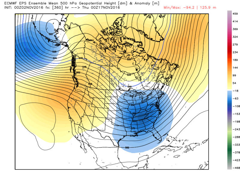
Good news is that image of the EPS EPO ends around the 12th but it looks like it is trending towards neutral and likely neg after that. If you look at the GEFS12z its similar around the 12th (approx neutral) before tanking negative. If you look at the Same time frame on the EPS anomaly Maps EPO looks negative and very similar to the GEF image you posted above.

_________________
"In weather and in life, there's no winning and losing; there's only winning and learning."
WINTER 2012/2013 TOTALS 43.65"WINTER 2017/2018 TOTALS 62.85" WINTER 2022/2023 TOTALS 4.9"
WINTER 2013/2014 TOTALS 64.85"WINTER 2018/2019 TOTALS 14.25" WINTER 2023/2024 TOTALS 13.1"
WINTER 2014/2015 TOTALS 71.20"WINTER 2019/2020 TOTALS 6.35"
WINTER 2015/2016 TOTALS 35.00"WINTER 2020/2021 TOTALS 37.75"
WINTER 2016/2017 TOTALS 42.25"WINTER 2021/2022 TOTALS 31.65"

sroc4- Admin

- Posts : 8442
Reputation : 302
Join date : 2013-01-07
Location : Wading River, LI
 Re: Long Range Thread 12.0
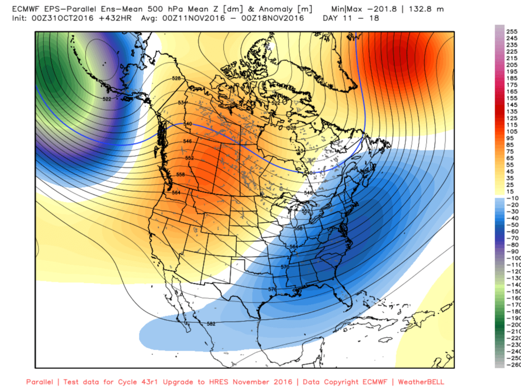
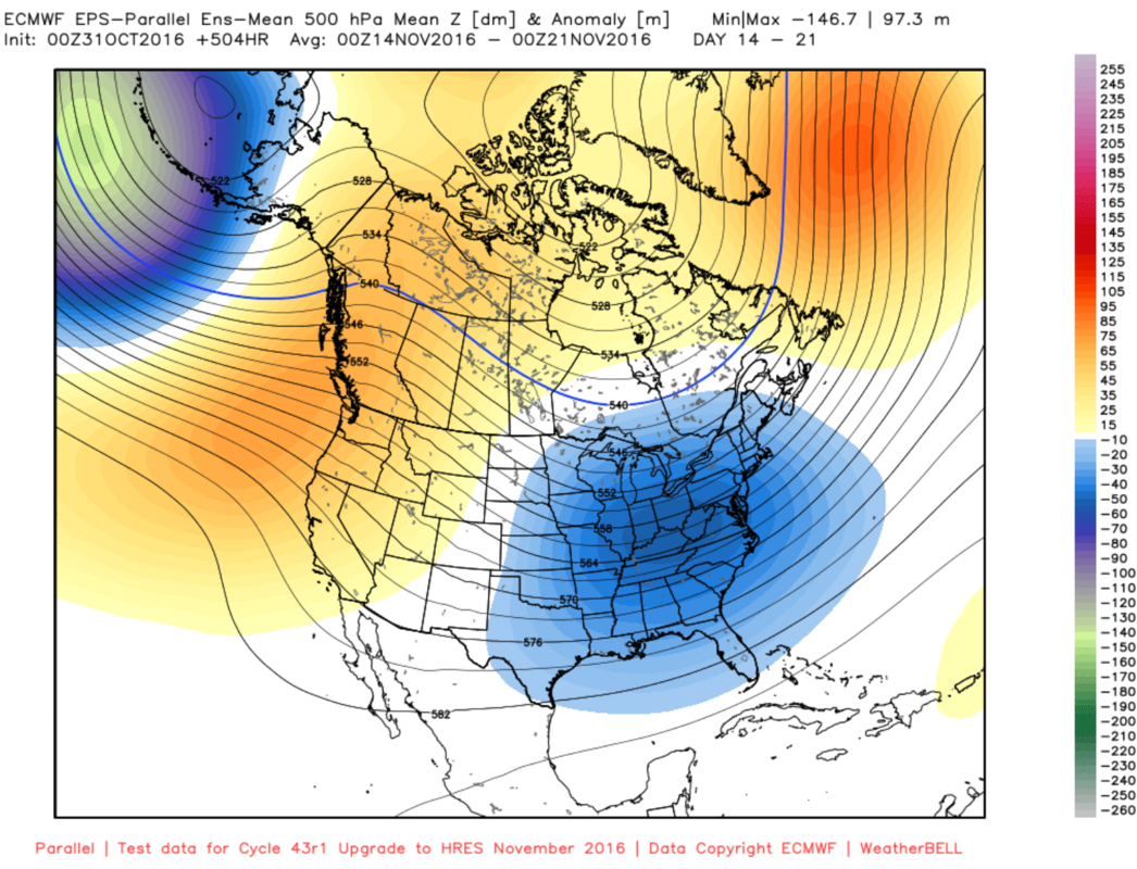
The EPS Parallel 500mb map in the long range is drool worthy. Matches GEFS nicely.
Day 11-18
Day 14-21
Day 11-18

Day 14-21

_________________
_______________________________________________________________________________________________________
CLICK HERE to view NJ Strong Snowstorm Classifications
 Re: Long Range Thread 12.0
Scott great point
Now how about the MJO
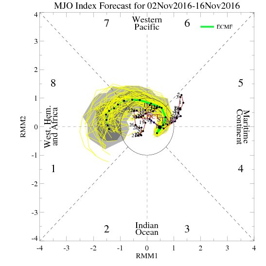

Now how about the MJO


_________________
Mugs
AKA:King: Snow Weenie
Self Proclaimed
WINTER 2014-15 : 55.12" +.02 for 6 coatings (avg. 35")
WINTER 2015-16 Total - 29.8" (Avg 35")
WINTER 2016-17 : 39.5" so far

amugs- Advanced Forecaster - Mod

- Posts : 15130
Reputation : 213
Join date : 2013-01-07
Age : 54
Location : Hillsdale,NJ
Page 15 of 40 •  1 ... 9 ... 14, 15, 16 ... 27 ... 40
Page 15 of 40
Permissions in this forum:
You cannot reply to topics in this forum|
|
|

 Home
Home