
 Search
Long Range Thread 12.0
Page 25 of 40 •  1 ... 14 ... 24, 25, 26 ... 32 ... 40
 ![]()
Re: Long Range Thread 12.0
![]() by sroc4 Sun Nov 27, 2016 10:12 am
by sroc4 Sun Nov 27, 2016 10:12 am
Frank_Wx wrote:I can't answer for Tom, Scott, but if you look at 2M or 850mb temps there actually is decent cold penetrating across the country the first half of December. It's a fast flow, but I'm thinking the high heights associated with the -EPO entering the Arctic help bring some of that cold air down. So while it may he cold, it looks pretty dry and if there is a storm I fear it will take an unfavorable track due to the ugly looking aforementioned signals.
Ahh I am finally back from vacation. Ive been in Chicago and Indiana for the past 8 days with the family. It was nice to actually wake up in my own bed this morning.
Anyway I totally see what your saying Frank. There is no doubt that the most likely scenario between now and the first week of Dec has any energy coming out of the N most likely phasing with S energy early forcing a storm track well west with warm temps out ahead. The system, for instance, coming through this upcoming week is a great example.


But just as this system lifts out at the same time a piece breaks off and backs into the SW once again to reinforce the -PNA. I guess my question was/is why the reinforced persistant -PNA? The trough in the SW CONUS has been one that has remained a constant since early November. This was a quote from my write up on Oct 29th:
"That trough sitting off the NW Coast MUST leave for the fundamental pattern change to occur because it leads to a warm source region that floods the nation with Pac air."
https://www.njstrongweatherforum.com/t745-fundamental-pattern-change-on-the-wind
Now as we head deeper into the winter season climo changes so the intensity of the ridge ahead of it has become somewhat muted relative to a month ago, but the point being that it persists none the less. And I believe it is a direct result of the Nina forcing's that have been present is some fashion since the beginning of Sept as seen by the OLR anomaly maps.
Mod MJO pulses running through phases 8, 1, and 2 throughout the later 2/3rds of Nov, combined with the -NAO and -AO, are responsible for our normal to below normal temp anomalies to this point, and likely was the reason our brothers and sisters to the NW were able to squeak out their first measurable snowfall of the season. Without these factors the -PNA would have likely allowed the SE ridging to dominate and we could have had a miserably warm Nov temp wise.
So now we see in the Md/LR the -EPO to start showing up, but at the same time the -NAO/-AO begin to get muted. The -PNA looks to remain unchanged however, and the MJO is looking a little incoherent at the moment but I'm concerned it comes out in 3-6 yet again as we head into Dec. Well see about that.

My concern is that the forecasted -EPO will not evolve as it may appear on LR modeling, because that always seems to be the case when looking at LR modeling. However, there is hope regarding that. When looking at the SSTA maps there has been significant warming going on in the region where the cold pool is over the last 7-14days as well as warming in the GOA
Recall this: The SSTA as of Nov 12th
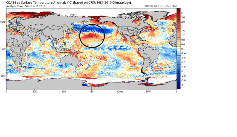
Now look at the curent SSTA:

The reason this may be significant is the strongest SST gradient may shift now from the N Central Pac like it has been, to the NE Pac now enhancing the -EPO ridge formation(A more classic +PDO setup) making the -EPO an actual real LR projection, rather than a fantasy LR projection. We shall see though. I am still skeptical, but if true the invasion of the Siberian/arctic air masses into NA, beginning with Canada and the Western CONUS will commence as we head into the first week of Dec.
Wild Cards: We will have to see how the MJO behaves and how the Nina forcings behave as they could be factors that mute the potential pole ward -EPO blocking influences esp if they work together. In addition a "west based" -EPO may play a role in keeping the coldest air in the west. The stratosphere may play a role beyond day 10, however, its influences will likely not be known for some time. There will likely not be any major changes to the strat and its influences on us for at least the next 10days.
sroc4- Admin

- Posts : 8331
Join date : 2013-01-07
Re: Long Range Thread 12.0
![]() by Frank_Wx Sun Nov 27, 2016 10:12 am
by Frank_Wx Sun Nov 27, 2016 10:12 am
Frank_Wx- Godzilla Seeker
- Posts : 21305
Join date : 2013-01-05 -

Re: Long Range Thread 12.0
![]() by algae888 Sun Nov 27, 2016 10:18 am
by algae888 Sun Nov 27, 2016 10:18 am

algae888- Advanced Forecaster

- Posts : 5311
Reputation : 46
Join date : 2013-02-05
Age : 61
Location : mt. vernon, new york
Re: Long Range Thread 12.0
![]() by algae888 Sun Nov 27, 2016 10:22 am
by algae888 Sun Nov 27, 2016 10:22 am
algae888- Advanced Forecaster
- Posts : 5311
Reputation : 46
Join date : 2013-02-05
Age : 61
Location : mt. vernon, new york
Re: Long Range Thread 12.0
![]() by Frank_Wx Sun Nov 27, 2016 10:52 am
by Frank_Wx Sun Nov 27, 2016 10:52 am
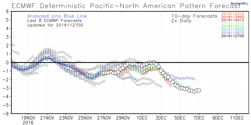
algae888 wrote:frank and scott help me understand this if you can. everywhere I read people are saying we have a -pna however nws shows pna has been + to neutral since late September? so which is right?
algae888 wrote:also can there be a persistent trough out west with a neutral to + pna?
These can kinda be answered together. Those oscillation graphics produced by the NWS do not do a great job in sensing or measuring wavelengths over a given area. They are also based off the GFS, a statistically poor model when it comes to oscillation forecasting. Here is the PNA forecast from the EURO. It went negative around Nov 22nd and will stay that way for the foreseeable future.
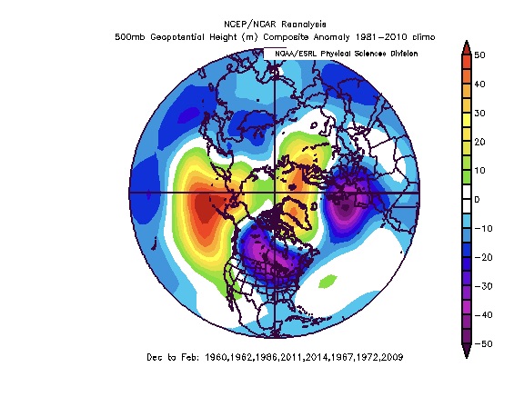
My rule of thumb is to look at the 500mb height anomalies to get a sense of what the real phase of any one signal is in. A persistent trough in the west almost always is a neutral to negative PNA.
https://2img.net/h/s3.postimg.cc/rfrfiv1nn/ecmwf_pna_bias.png
_________________
_______________________________________________________________________________________________________
CLICK HERE to view NJ Strong Snowstorm Classifications

Frank_Wx- Godzilla Seeker
- Posts : 21305
Reputation : 328
Join date : 2013-01-05
Age : 31
Location : Jersey City, NJ -
Re: Long Range Thread 12.0
![]() by algae888 Sun Nov 27, 2016 11:03 am
by algae888 Sun Nov 27, 2016 11:03 am
algae888- Advanced Forecaster
- Posts : 5311
Reputation : 46
Join date : 2013-02-05
Age : 61
Location : mt. vernon, new york
Re: Long Range Thread 12.0
![]() by sroc4 Sun Nov 27, 2016 11:41 am
by sroc4 Sun Nov 27, 2016 11:41 am
Frank_Wx wrote:algae888 wrote:frank and scott help me understand this if you can. everywhere I read people are saying we have a -pna however nws shows pna has been + to neutral since late September? so which is right?algae888 wrote:also can there be a persistent trough out west with a neutral to + pna?
These can kinda be answered together. Those oscillation graphics produced by the NWS do not do a great job in sensing or measuring wavelengths over a given area. They are also based off the GFS, a statistically poor model when it comes to oscillation forecasting. Here is the PNA forecast from the EURO. It went negative around Nov 22nd and will stay that way for the foreseeable future.
My rule of thumb is to look at the 500mb height anomalies to get a sense of what the real phase of any one signal is in. A persistent trough in the west almost always is a neutral to negative PNA.
https://2img.net/h/s3.postimg.cc/rfrfiv1nn/ecmwf_pna_bias.png
Exactly. And to show wjy I don't use that NWS graph for teles here is the Euro, EPS, GFS, and GEFS for the PNA through weather bell. Like Frank said looking at the 500mb pattern in the west for the PNA the WB graphs seem much more realistic. I mean look at the difference in the forecasted GFS ensembles on that NWS graph vs weatherbell, then look at the 500mb forecasts.


_________________
"In weather and in life, there's no winning and losing; there's only winning and learning."
WINTER 2012/2013 TOTALS 43.65"WINTER 2017/2018 TOTALS 62.85" WINTER 2022/2023 TOTALS 4.9"
WINTER 2013/2014 TOTALS 64.85"WINTER 2018/2019 TOTALS 14.25" WINTER 2023/2024 TOTALS 13.1"
WINTER 2014/2015 TOTALS 71.20"WINTER 2019/2020 TOTALS 6.35"
WINTER 2015/2016 TOTALS 35.00"WINTER 2020/2021 TOTALS 37.75"
WINTER 2016/2017 TOTALS 42.25"WINTER 2021/2022 TOTALS 31.65"

sroc4- Admin
- Posts : 8331
Reputation : 301
Join date : 2013-01-07
Location : Wading River, LI
Re: Long Range Thread 12.0
![]() by Frank_Wx Sun Nov 27, 2016 12:45 pm
by Frank_Wx Sun Nov 27, 2016 12:45 pm


_________________
_______________________________________________________________________________________________________
CLICK HERE to view NJ Strong Snowstorm Classifications
Frank_Wx- Godzilla Seeker
- Posts : 21305
Reputation : 328
Join date : 2013-01-05
Age : 31
Location : Jersey City, NJ -
Re: Long Range Thread 12.0
![]() by Frank_Wx Sun Nov 27, 2016 12:47 pm
by Frank_Wx Sun Nov 27, 2016 12:47 pm
_________________
_______________________________________________________________________________________________________
CLICK HERE to view NJ Strong Snowstorm Classifications
Frank_Wx- Godzilla Seeker
- Posts : 21305
Reputation : 328
Join date : 2013-01-05
Age : 31
Location : Jersey City, NJ -
Re: Long Range Thread 12.0
![]() by sroc4 Sun Nov 27, 2016 12:54 pm
by sroc4 Sun Nov 27, 2016 12:54 pm
_________________
"In weather and in life, there's no winning and losing; there's only winning and learning."
WINTER 2012/2013 TOTALS 43.65"WINTER 2017/2018 TOTALS 62.85" WINTER 2022/2023 TOTALS 4.9"
WINTER 2013/2014 TOTALS 64.85"WINTER 2018/2019 TOTALS 14.25" WINTER 2023/2024 TOTALS 13.1"
WINTER 2014/2015 TOTALS 71.20"WINTER 2019/2020 TOTALS 6.35"
WINTER 2015/2016 TOTALS 35.00"WINTER 2020/2021 TOTALS 37.75"
WINTER 2016/2017 TOTALS 42.25"WINTER 2021/2022 TOTALS 31.65"
sroc4- Admin
- Posts : 8331
Reputation : 301
Join date : 2013-01-07
Location : Wading River, LI
Re: Long Range Thread 12.0
![]() by algae888 Sun Nov 27, 2016 1:54 pm
by algae888 Sun Nov 27, 2016 1:54 pm


Last edited by algae888 on Sun Nov 27, 2016 2:06 pm; edited 1 time in total
algae888- Advanced Forecaster
- Posts : 5311
Reputation : 46
Join date : 2013-02-05
Age : 61
Location : mt. vernon, new york
Re: Long Range Thread 12.0
![]() by algae888 Sun Nov 27, 2016 2:01 pm
by algae888 Sun Nov 27, 2016 2:01 pm
12z euro has the same intensity with high pressure except its West. Get ready the cold is comingFrank_Wx wrote:That was an interesting 12z GFS run. Look at what it did with the -EPO ridge. Instead of confining it to the Aleutians it cut it off over Alaska

algae888- Advanced Forecaster
- Posts : 5311
Reputation : 46
Join date : 2013-02-05
Age : 61
Location : mt. vernon, new york
Re: Long Range Thread 12.0
![]() by algae888 Sun Nov 27, 2016 2:12 pm
by algae888 Sun Nov 27, 2016 2:12 pm
looks like todays gfs
algae888- Advanced Forecaster
- Posts : 5311
Reputation : 46
Join date : 2013-02-05
Age : 61
Location : mt. vernon, new york
Re: Long Range Thread 12.0
![]() by algae888 Sun Nov 27, 2016 2:27 pm
by algae888 Sun Nov 27, 2016 2:27 pm
algae888- Advanced Forecaster
- Posts : 5311
Reputation : 46
Join date : 2013-02-05
Age : 61
Location : mt. vernon, new york
Re: Long Range Thread 12.0
![]() by amugs Sun Nov 27, 2016 2:31 pm
by amugs Sun Nov 27, 2016 2:31 pm

This would be sick if it verifies - skeptic yes BUT IF those extreme heights build over the NW Alaska and we have which we will a good base of snow in the NW CONUS and Central Conus the air will have trouble modifying and this could very well happen - slosh tube effect JB has been harping on and something I discussed with a pro met who worked for NOAA in Alaska for 12 years and now works for meteo? in NY State and New England. Lyndon State grad in 2000.
He said that at this time of year if yuo build heights over the top it forms an alley so to speak for cold air to drain into the CONUS - not saying a snowy pattern but IF we get a gradient set up with a SE ridge as this map shows then ala 93-94 and you can take your -PNA.

Also, the wetness this week will help not only the drought conditions but the cold and precip for storms as we move forward - soil less ground raises temps and wet ground keeps things cooler, hydro cycle.
_________________
Mugs
AKA:King: Snow Weenie
Self Proclaimed
WINTER 2014-15 : 55.12" +.02 for 6 coatings (avg. 35")
WINTER 2015-16 Total - 29.8" (Avg 35")
WINTER 2016-17 : 39.5" so far

amugs- Advanced Forecaster - Mod

- Posts : 15093
Reputation : 213
Join date : 2013-01-07
Age : 54
Location : Hillsdale,NJ
Re: Long Range Thread 12.0
![]() by Dunnzoo Sun Nov 27, 2016 2:33 pm
by Dunnzoo Sun Nov 27, 2016 2:33 pm
algae888 wrote:this is the best early dec pattern we have had in 6 years. ill take this pattern any year for early December and looks more interesting as we move deeper into month. does that Aleutian ridge move right over Alaska post 10 day on op euro to match gfs? hmm
I'm with you! Anything would be better than last year. December usually isn't too exciting in these parts anyway, so seeing the cold coming is a plus. We are in a pretty decent wet pattern, so sooner or later we'll see snow. I'm trying not to model hug, just trying to work on rain timing for this week since I am on vacation!
_________________
Janet
Snowfall winter of 2023-2024 17.5"
Snowfall winter of 2022-2023 6.0"
Snowfall winter of 2021-2022 17.6" 1" sleet 2/25/22
Snowfall winter of 2020-2021 51.1"
Snowfall winter of 2019-2020 8.5"
Snowfall winter of 2018-2019 25.1"
Snowfall winter of 2017-2018 51.9"
Snowfall winter of 2016-2017 45.6"
Snowfall winter of 2015-2016 29.5"
Snowfall winter of 2014-2015 50.55"
Snowfall winter of 2013-2014 66.5"

Dunnzoo- Senior Enthusiast - Mod
- Posts : 4891
Reputation : 68
Join date : 2013-01-11
Age : 62
Location : Westwood, NJ
Re: Long Range Thread 12.0
![]() by Frank_Wx Sun Nov 27, 2016 3:29 pm
by Frank_Wx Sun Nov 27, 2016 3:29 pm
algae888 wrote:wonder if dec ends up like this? from another poster weak nina/+qbo
looks like todays gfs
Look at the blocking from northern Europe (Scandinavia) to Greenland. I do not see that anywhere on any models.
algae888 wrote:this is the best early dec pattern we have had in 6 years. ill take this pattern any year for early December and looks more interesting as we move deeper into month. does that Aleutian ridge move right over Alaska post 10 day on op euro to match gfs? hmm
This is THE most important question we have to answer this week. It will determine our December.
_________________
_______________________________________________________________________________________________________
CLICK HERE to view NJ Strong Snowstorm Classifications
Frank_Wx- Godzilla Seeker
- Posts : 21305
Reputation : 328
Join date : 2013-01-05
Age : 31
Location : Jersey City, NJ -
Re: Long Range Thread 12.0
![]() by Frank_Wx Sun Nov 27, 2016 7:41 pm
by Frank_Wx Sun Nov 27, 2016 7:41 pm


_________________
_______________________________________________________________________________________________________
CLICK HERE to view NJ Strong Snowstorm Classifications
Frank_Wx- Godzilla Seeker
- Posts : 21305
Reputation : 328
Join date : 2013-01-05
Age : 31
Location : Jersey City, NJ -
Re: Long Range Thread 12.0
![]() by algae888 Mon Nov 28, 2016 3:18 am
by algae888 Mon Nov 28, 2016 3:18 am


gfs and cmc then eject the energy east by the 7th.


cmc is well south and gets sheared and gfs forms a weak coastal.
the euro on the other hand amps up the energy in the gulf and it cuts.


here is the gfs and euro at 500mb on sunday night the 4th.

big difference.

here is what I like about set up esp on euro.
we have a block over Hudson bay a 50/50 low and hp over southern Canada. if system doesn't get as amp as euro depicts, which it sometimes does, then this system has a chance to stay south of us and maybe redevelop off coast allowing for a colder solution. either way we have a good shot at seeing snow either on the front end (cuts) with hp and cold air damming as 00z euro depicts or if low takes a track further south with colder solution. stay tuned
algae888- Advanced Forecaster
- Posts : 5311
Reputation : 46
Join date : 2013-02-05
Age : 61
Location : mt. vernon, new york
Re: Long Range Thread 12.0
![]() by algae888 Mon Nov 28, 2016 3:30 am
by algae888 Mon Nov 28, 2016 3:30 am


algae888- Advanced Forecaster
- Posts : 5311
Reputation : 46
Join date : 2013-02-05
Age : 61
Location : mt. vernon, new york
Re: Long Range Thread 12.0
![]() by algae888 Mon Nov 28, 2016 3:34 am
by algae888 Mon Nov 28, 2016 3:34 am

12z

00z
look at that hp over Siberia and arctic.
algae888- Advanced Forecaster
- Posts : 5311
Reputation : 46
Join date : 2013-02-05
Age : 61
Location : mt. vernon, new york
Re: Long Range Thread 12.0
![]() by algae888 Mon Nov 28, 2016 3:42 am
by algae888 Mon Nov 28, 2016 3:42 am

obviously not as amped. that's a descent look. 7 days out so a lot can change
algae888- Advanced Forecaster
- Posts : 5311
Reputation : 46
Join date : 2013-02-05
Age : 61
Location : mt. vernon, new york
Re: Long Range Thread 12.0
![]() by Guest Mon Nov 28, 2016 8:12 am
by Guest Mon Nov 28, 2016 8:12 am
Guest- Guest
Re: Long Range Thread 12.0
![]() by rb924119 Mon Nov 28, 2016 8:14 am
by rb924119 Mon Nov 28, 2016 8:14 am
rb924119- Meteorologist

- Posts : 6890
Reputation : 194
Join date : 2013-02-06
Age : 32
Location : Greentown, Pa
Re: Long Range Thread 12.0
![]() by amugs Mon Nov 28, 2016 11:04 am
by amugs Mon Nov 28, 2016 11:04 am
syosnow94 wrote:Cutters in early December don't excite me. Sorry!
I hear ya BUT what we need understand is that cutter can be and a prelude at times (many actually) to a changing pattern and help start to set things up as we move forward - ala 50/50 block, blanket a cold pool of air source in Canada, help break the dam of cut off Arctic air etc. So I will take a cutter or two to help do this which I think starts to occur.
Jim, I want a snowstorm as bad as the next weenie on this board but understand which I know yuo do that we things to take shape and cutters help this occur.
Last edited by amugs on Mon Nov 28, 2016 2:54 pm; edited 1 time in total
_________________
Mugs
AKA:King: Snow Weenie
Self Proclaimed
WINTER 2014-15 : 55.12" +.02 for 6 coatings (avg. 35")
WINTER 2015-16 Total - 29.8" (Avg 35")
WINTER 2016-17 : 39.5" so far
amugs- Advanced Forecaster - Mod
- Posts : 15093
Reputation : 213
Join date : 2013-01-07
Age : 54
Location : Hillsdale,NJ
Re: Long Range Thread 12.0
![]() by sroc4 Mon Nov 28, 2016 12:03 pm
by sroc4 Mon Nov 28, 2016 12:03 pm
amugs wrote:syosnow94 wrote:Cutters in early December don't excite me. Sorry!
I hear ya BUT what we need understand is that cutter can be and a re prelude at times (many actually) to a changing pattern and help start to set thing sup as we move forward - ala 50/50 block, blanket a cold pol of air source in Canada, help break teh dam of cut off Arctic air etc. So I will take a cutter or two to help do this which I think start to occur.
Jim, I want a snowstorm as bad as the next weenie on this board but understand which I know yuo do that we things to take shape and cutters help this occur.
Agree!!!
_________________
"In weather and in life, there's no winning and losing; there's only winning and learning."
WINTER 2012/2013 TOTALS 43.65"WINTER 2017/2018 TOTALS 62.85" WINTER 2022/2023 TOTALS 4.9"
WINTER 2013/2014 TOTALS 64.85"WINTER 2018/2019 TOTALS 14.25" WINTER 2023/2024 TOTALS 13.1"
WINTER 2014/2015 TOTALS 71.20"WINTER 2019/2020 TOTALS 6.35"
WINTER 2015/2016 TOTALS 35.00"WINTER 2020/2021 TOTALS 37.75"
WINTER 2016/2017 TOTALS 42.25"WINTER 2021/2022 TOTALS 31.65"
sroc4- Admin
- Posts : 8331
Reputation : 301
Join date : 2013-01-07
Location : Wading River, LI
Re: Long Range Thread 12.0
![]() by Snow88 Mon Nov 28, 2016 1:43 pm
by Snow88 Mon Nov 28, 2016 1:43 pm

Snow88- Senior Enthusiast

- Posts : 2193
Reputation : 4
Join date : 2013-01-09
Age : 35
Location : Brooklyn, NY
Page 25 of 40 • 1 ... 14 ... 24, 25, 26 ... 32 ... 40 ![]()
|
|
|