
 Search
Long Range Thread 12.0
Page 24 of 40 •  1 ... 13 ... 23, 24, 25 ... 32 ... 40
 ![]()
Re: Long Range Thread 12.0
![]() by Frank_Wx Fri Nov 25, 2016 9:11 pm
by Frank_Wx Fri Nov 25, 2016 9:11 pm


200mb winds for November so far. Very active PAC jet.

Frank_Wx- Godzilla Seeker

- Posts : 21305
Join date : 2013-01-05 -

Re: Long Range Thread 12.0
![]() by sroc4 Fri Nov 25, 2016 9:50 pm
by sroc4 Fri Nov 25, 2016 9:50 pm
sroc4- Admin
- Posts : 8331
Join date : 2013-01-07
Re: Long Range Thread 12.0
![]() by sroc4 Fri Nov 25, 2016 10:17 pm
by sroc4 Fri Nov 25, 2016 10:17 pm
Now if you recall the reason we like the warm blob in the NE Pac/GOA is because the temp gradients between SSTA tend to favor ridging that extends up into Alaska and the West coast of Canada and the CONUS (-EPO and +PNA respectively) when you have that warm blob in the GOA. However; as you can see the strongest temp gradient is set up in a distinct horizontal fashion from west to east, but is no longer strongest near the GOA. Now notice there is the warmest SSTA of the N Hemispheric Pac ocean smack dab in the center of the Pac due south of the prev described cold anomalies. It is right here in this location that we have the greatest differences in the SSTA. NOTE: If this SSTA configuration conts into the winter it might spell disaster without other large scale pattern changes to help us out. Things like a strong MJO pulse in favorable phases or a strat warming event to name a couple.
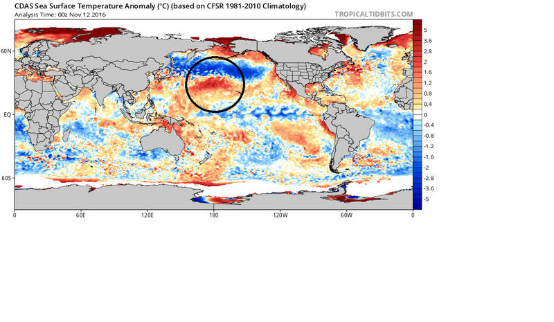
Likely NOT coincidentally an HP ridge is centered in the Central Pac and due north is the exceptionally strong N Pac jet.
_________________
"In weather and in life, there's no winning and losing; there's only winning and learning."
WINTER 2012/2013 TOTALS 43.65"WINTER 2017/2018 TOTALS 62.85" WINTER 2022/2023 TOTALS 4.9"
WINTER 2013/2014 TOTALS 64.85"WINTER 2018/2019 TOTALS 14.25" WINTER 2023/2024 TOTALS 13.1"
WINTER 2014/2015 TOTALS 71.20"WINTER 2019/2020 TOTALS 6.35"
WINTER 2015/2016 TOTALS 35.00"WINTER 2020/2021 TOTALS 37.75"
WINTER 2016/2017 TOTALS 42.25"WINTER 2021/2022 TOTALS 31.65"

sroc4- Admin
- Posts : 8331
Reputation : 301
Join date : 2013-01-07
Location : Wading River, LI
Re: Long Range Thread 12.0
![]() by amugs Fri Nov 25, 2016 11:22 pm
by amugs Fri Nov 25, 2016 11:22 pm

_________________
Mugs
AKA:King: Snow Weenie
Self Proclaimed
WINTER 2014-15 : 55.12" +.02 for 6 coatings (avg. 35")
WINTER 2015-16 Total - 29.8" (Avg 35")
WINTER 2016-17 : 39.5" so far

amugs- Advanced Forecaster - Mod

- Posts : 15093
Reputation : 213
Join date : 2013-01-07
Age : 54
Location : Hillsdale,NJ
Re: Long Range Thread 12.0
![]() by Frank_Wx Sat Nov 26, 2016 9:18 am
by Frank_Wx Sat Nov 26, 2016 9:18 am
sroc4 wrote:From November 12th:
Now if you recall the reason we like the warm blob in the NE Pac/GOA is because the temp gradients between SSTA tend to favor ridging that extends up into Alaska and the West coast of Canada and the CONUS (-EPO and +PNA respectively) when you have that warm blob in the GOA. However; as you can see the strongest temp gradient is set up in a distinct horizontal fashion from west to east, but is no longer strongest near the GOA. Now notice there is the warmest SSTA of the N Hemispheric Pac ocean smack dab in the center of the Pac due south of the prev described cold anomalies. It is right here in this location that we have the greatest differences in the SSTA. NOTE: If this SSTA configuration conts into the winter it might spell disaster without other large scale pattern changes to help us out. Things like a strong MJO pulse in favorable phases or a strat warming event to name a couple.
Likely NOT coincidentally an HP ridge is centered in the Central Pac and due north is the exceptionally strong N Pac jet.
Nice Scott. Missed this post. But yea, it is concerning that the strongest gradients are west of the PDO region and it's no coincidence the ridging is setting up over the Aleutians opposed to Alaska.
Last edited by Frank_Wx on Sat Nov 26, 2016 9:19 am; edited 1 time in total
_________________
_______________________________________________________________________________________________________
CLICK HERE to view NJ Strong Snowstorm Classifications

Frank_Wx- Godzilla Seeker
- Posts : 21305
Reputation : 328
Join date : 2013-01-05
Age : 31
Location : Jersey City, NJ -
Re: Long Range Thread 12.0
![]() by Frank_Wx Sat Nov 26, 2016 9:19 am
by Frank_Wx Sat Nov 26, 2016 9:19 am

_________________
_______________________________________________________________________________________________________
CLICK HERE to view NJ Strong Snowstorm Classifications
Frank_Wx- Godzilla Seeker
- Posts : 21305
Reputation : 328
Join date : 2013-01-05
Age : 31
Location : Jersey City, NJ -
Re: Long Range Thread 12.0
![]() by amugs Sat Nov 26, 2016 9:21 am
by amugs Sat Nov 26, 2016 9:21 am
_________________
Mugs
AKA:King: Snow Weenie
Self Proclaimed
WINTER 2014-15 : 55.12" +.02 for 6 coatings (avg. 35")
WINTER 2015-16 Total - 29.8" (Avg 35")
WINTER 2016-17 : 39.5" so far
amugs- Advanced Forecaster - Mod
- Posts : 15093
Reputation : 213
Join date : 2013-01-07
Age : 54
Location : Hillsdale,NJ
Re: Long Range Thread 12.0
![]() by algae888 Sat Nov 26, 2016 9:21 am
by algae888 Sat Nov 26, 2016 9:21 am

algae888- Advanced Forecaster

- Posts : 5311
Reputation : 46
Join date : 2013-02-05
Age : 61
Location : mt. vernon, new york
Re: Long Range Thread 12.0
![]() by algae888 Sat Nov 26, 2016 9:30 am
by algae888 Sat Nov 26, 2016 9:30 am
Last edited by algae888 on Sat Nov 26, 2016 9:31 am; edited 1 time in total
algae888- Advanced Forecaster
- Posts : 5311
Reputation : 46
Join date : 2013-02-05
Age : 61
Location : mt. vernon, new york
Re: Long Range Thread 12.0
![]() by Frank_Wx Sat Nov 26, 2016 9:31 am
by Frank_Wx Sat Nov 26, 2016 9:31 am
algae888 wrote:Looking at guidance a little confused with the pessimism about the upcoming pattern for the first half of December. The Pacific is definitely changing with a huge negative EPO Ridge and the Piece of the polar vortex sitting over or just north of Hudson Bay with a nice cross polar flow day 5 Plus. Early December looks below normal. This is the best December set up we've had in years and it wouldn't take much for us to score of first snowfall even down to the coast. We have the main and number one ingredient cold air to work with. Now we just need a system to slide underneath us. I'm not calling for any major storm the first half of December but a minor or moderate accumulating snow is a good possibility. The second half of December onward is a crapshoot euro weeklies look good we shall see
The PV is on the other side of the globe so we're not going to see Arctic air masses anytime soon. That's fine, because December is the time of year thanks to low sun angle when we don't need Arctic air masses to see snow accumulate.
My one concern with the negative EPO models are showing is that the center of the ridge is displaced pretty far west in the NPAC. While heights will rise over Alaska and parts of the western Arctic, they're oriented in a way that the upper level energy digs into the PAC NW instead of the Rockies or Midwest so the PNA remains largely negative.
It's quite possible a trough forms on both coasts of the U.S., but what's most likely to happen is a SWFE pattern forms (southwest flow event). It doesn't help that the AO and NAO are expected to go positive in early December too. (AO will probably be more neutral)
_________________
_______________________________________________________________________________________________________
CLICK HERE to view NJ Strong Snowstorm Classifications
Frank_Wx- Godzilla Seeker
- Posts : 21305
Reputation : 328
Join date : 2013-01-05
Age : 31
Location : Jersey City, NJ -
Re: Long Range Thread 12.0
![]() by algae888 Sat Nov 26, 2016 9:37 am
by algae888 Sat Nov 26, 2016 9:37 am
Frank have to disagree somewhat most guidance is showing very cold air for most of Canada and the Western us and there's no sign of the southeast Ridge on long-range guidance. Warm Waters have been building south of Greenland and cool water south of Iceland which favors and negative Nao. It won't take much to get that cold air into the Northeast. The euro is below normal for most of the u.s. day 5 plus. Not the best set up for us but definitely workableFrank_Wx wrote:algae888 wrote:Looking at guidance a little confused with the pessimism about the upcoming pattern for the first half of December. The Pacific is definitely changing with a huge negative EPO Ridge and the Piece of the polar vortex sitting over or just north of Hudson Bay with a nice cross polar flow day 5 Plus. Early December looks below normal. This is the best December set up we've had in years and it wouldn't take much for us to score of first snowfall even down to the coast. We have the main and number one ingredient cold air to work with. Now we just need a system to slide underneath us. I'm not calling for any major storm the first half of December but a minor or moderate accumulating snow is a good possibility. The second half of December onward is a crapshoot euro weeklies look good we shall see
The PV is on the other side of the globe so we're not going to see Arctic air masses anytime soon. That's fine, because December is the time of year thanks to low sun angle when we don't need Arctic air masses to see snow accumulate.
My one concern with the negative EPO models are showing is that the center of the ridge is displaced pretty far west in the NPAC. While heights will rise over Alaska and parts of the western Arctic, they're oriented in a way that the upper level energy digs into the PAC NW instead of the Rockies or Midwest so the PNA remains largely negative.
It's quite possible a trough forms on both coasts of the U.S., but what's most likely to happen is a SWFE pattern forms (southwest flow event). It doesn't help that the AO and NAO are expected to go positive in early December too. (AO will probably be more neutral)
algae888- Advanced Forecaster
- Posts : 5311
Reputation : 46
Join date : 2013-02-05
Age : 61
Location : mt. vernon, new york
Re: Long Range Thread 12.0
![]() by Frank_Wx Sat Nov 26, 2016 9:41 am
by Frank_Wx Sat Nov 26, 2016 9:41 am
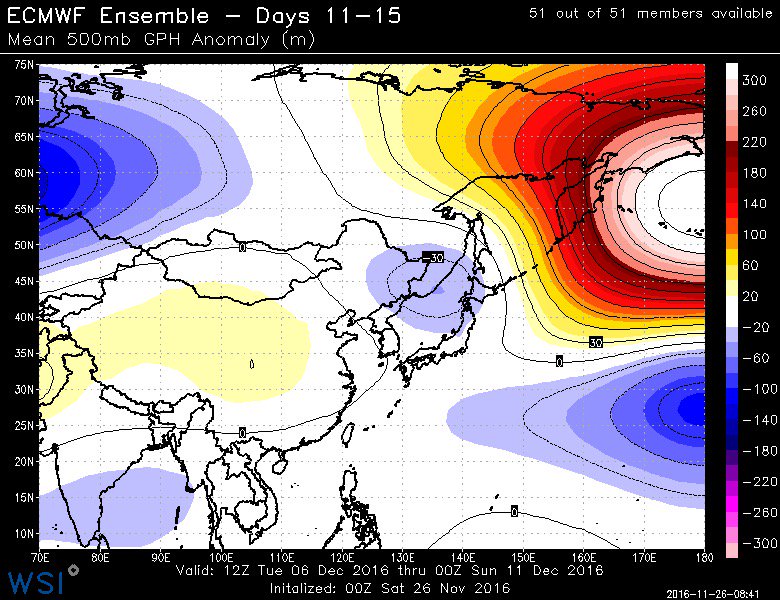
Current State:

Possible Future State:

That Siberian High is very important. Sends the Trop PV back on our side of the globe while the Strat PV experiences constant wave 1 attacks.
_________________
_______________________________________________________________________________________________________
CLICK HERE to view NJ Strong Snowstorm Classifications
Frank_Wx- Godzilla Seeker
- Posts : 21305
Reputation : 328
Join date : 2013-01-05
Age : 31
Location : Jersey City, NJ -
Re: Long Range Thread 12.0
![]() by algae888 Sat Nov 26, 2016 9:44 am
by algae888 Sat Nov 26, 2016 9:44 am
algae888- Advanced Forecaster
- Posts : 5311
Reputation : 46
Join date : 2013-02-05
Age : 61
Location : mt. vernon, new york
Re: Long Range Thread 12.0
![]() by algae888 Sat Nov 26, 2016 9:45 am
by algae888 Sat Nov 26, 2016 9:45 am
algae888- Advanced Forecaster
- Posts : 5311
Reputation : 46
Join date : 2013-02-05
Age : 61
Location : mt. vernon, new york
Re: Long Range Thread 12.0
![]() by algae888 Sat Nov 26, 2016 9:52 am
by algae888 Sat Nov 26, 2016 9:52 am
algae888- Advanced Forecaster
- Posts : 5311
Reputation : 46
Join date : 2013-02-05
Age : 61
Location : mt. vernon, new york
Re: Long Range Thread 12.0
![]() by Frank_Wx Sat Nov 26, 2016 10:00 am
by Frank_Wx Sat Nov 26, 2016 10:00 am
algae888 wrote:Frank have to disagree somewhat most guidance is showing very cold air for most of Canada and the Western us and there's no sign of the southeast Ridge on long-range guidance. Warm Waters have been building south of Greenland and cool water south of Iceland which favors and negative Nao. It won't take much to get that cold air into the Northeast. The euro is below normal for most of the u.s. day 5 plus. Not the best set up for us but definitely workableFrank_Wx wrote:algae888 wrote:Looking at guidance a little confused with the pessimism about the upcoming pattern for the first half of December. The Pacific is definitely changing with a huge negative EPO Ridge and the Piece of the polar vortex sitting over or just north of Hudson Bay with a nice cross polar flow day 5 Plus. Early December looks below normal. This is the best December set up we've had in years and it wouldn't take much for us to score of first snowfall even down to the coast. We have the main and number one ingredient cold air to work with. Now we just need a system to slide underneath us. I'm not calling for any major storm the first half of December but a minor or moderate accumulating snow is a good possibility. The second half of December onward is a crapshoot euro weeklies look good we shall see
The PV is on the other side of the globe so we're not going to see Arctic air masses anytime soon. That's fine, because December is the time of year thanks to low sun angle when we don't need Arctic air masses to see snow accumulate.
My one concern with the negative EPO models are showing is that the center of the ridge is displaced pretty far west in the NPAC. While heights will rise over Alaska and parts of the western Arctic, they're oriented in a way that the upper level energy digs into the PAC NW instead of the Rockies or Midwest so the PNA remains largely negative.
It's quite possible a trough forms on both coasts of the U.S., but what's most likely to happen is a SWFE pattern forms (southwest flow event). It doesn't help that the AO and NAO are expected to go positive in early December too. (AO will probably be more neutral)
Let's check out the GFS Ensembles in the medium to long range. These are 5 day average 500mb height anonalies.
Days 4 to 8:

A broad scale trough is found over the center of the country. Notice as you head to the east coast heights begin to rise because the upper air energy associated with that trough is dug into the Southwest U.S. The SE ridge is shunted to the Caribbean but we're essentially stuck between the two. This is why we'll see 1 cutter and 1 apps runner between today and December 2nd. Heights over the EC are rising and temps are in the 50s and 60s in the process.
Days 6 to 10:

The ridge is favorably oriented N to S off the west coast and there's still positive heights rises west of Greenland. This will be a good period to see colder than normal temps with a possible shot at a snowstorm. However, the trough over the east remains broad in nature and the flow still looks fast. Blocking upstream is not favorably positioned to slow the flow as much as we'd like. We need to hope a wave ejects from the south and rides into the cold air over our area. Unfortunately, models are either suppressing the waves or trying to cut a storm west as they find a weakness in the ridging over the Hudson.
Day 11 to 14

The flow across the U.S. looks zonal and the trough is now centered over the Atlantic because of the lack of upstream blocking. We're not baking under a SE ridge thanks to the -EPO, but it's still not a pattern that screams snowstorms to me.
It's not a horrifying pattern. NOTHING like last December. This pattern favors snowstorms for New England and interior Northeast. Let's just see the PAC jet slowdown and allow heights rises over the NE PAC and western U.S. And I would like to see a better positioned block too.
_________________
_______________________________________________________________________________________________________
CLICK HERE to view NJ Strong Snowstorm Classifications
Frank_Wx- Godzilla Seeker
- Posts : 21305
Reputation : 328
Join date : 2013-01-05
Age : 31
Location : Jersey City, NJ -
Re: Long Range Thread 12.0
![]() by Frank_Wx Sat Nov 26, 2016 10:01 am
by Frank_Wx Sat Nov 26, 2016 10:01 am
algae888 wrote:Yes Frank that's what I'm seeing that would send arctic right through western Canada into the Western us and without a Southeast Ridge that has to bleed East
Yea it's nice to see but also 384 hours out. If this signal is still there this time next week then I'll get excited.
_________________
_______________________________________________________________________________________________________
CLICK HERE to view NJ Strong Snowstorm Classifications
Frank_Wx- Godzilla Seeker
- Posts : 21305
Reputation : 328
Join date : 2013-01-05
Age : 31
Location : Jersey City, NJ -
Re: Long Range Thread 12.0
![]() by Isotherm Sat Nov 26, 2016 10:23 am
by Isotherm Sat Nov 26, 2016 10:23 am
Regarding the stratosphere, I see a pattern conducive for wave-1 convergence which is reflected in model data for the medium term (and subsequently a minor weakening), but the tropospheric regime thereafter (second week of December) appears to transition quite unfavorable for any effective Rossby wave propagation. Wave-2 has been extremely low and should remain there. I think the stratospheric vortex will generally strengthen as December progresses, following one wave-1 attack. The BDC is more active this year compared to last, but its effects might be mitigated by other factors.
On the ECMWF ensembles, we see that the AO/NAO domain higher than normal geopotential heights are essentially dissolved by the end of the run. This will be something important to monitor as we move forward.
I actually think that 12/5-7 period might be a better window of opportunity for "something" at the coast rather than the second week of December. There will be a contemporaneous pulse of conducive -NAO and poleward Pacific ridging, as one of those short waves traverses the CONUS. The Atlantic side pattern may worsen as we move into the second week of December.
Isotherm- Advanced Forecaster
- Posts : 231
Reputation : 4
Join date : 2014-09-01
Age : 33
Location : Monmouth County, NJ -
Re: Long Range Thread 12.0
![]() by Frank_Wx Sat Nov 26, 2016 2:31 pm
by Frank_Wx Sat Nov 26, 2016 2:31 pm
_________________
_______________________________________________________________________________________________________
CLICK HERE to view NJ Strong Snowstorm Classifications
Frank_Wx- Godzilla Seeker
- Posts : 21305
Reputation : 328
Join date : 2013-01-05
Age : 31
Location : Jersey City, NJ -
Re: Long Range Thread 12.0
![]() by Isotherm Sat Nov 26, 2016 3:29 pm
by Isotherm Sat Nov 26, 2016 3:29 pm
Frank_Wx wrote:Tom - between the dissipating AO/NAO and -PNA, I think we're in for an ugly looking mid December. Hopefully around the holidays the pattern turns favorable. But to me, 2/3 of this month looks like trash. And cold we get will be transient or not accompanied with any storm threats.
Pretty much agreed Frank. My outlook period for our best window was Dec 15th-early Jan, so hopefully with improving climatology and a strong poleward ridge, we can manage something before the holidays. Last white Christmas locally was 2009 (2010 happened the day after, so close). From a non-scientific standpoint, we're certainly due. But I'm concerned that we won't have sufficient AO/NAO domain blocking in the second half of December either. The pattern extrapolated with those indices would likely imply sleigh riding for folks north of about 42N and potentially as far south as 41N.
Isotherm- Advanced Forecaster
- Posts : 231
Reputation : 4
Join date : 2014-09-01
Age : 33
Location : Monmouth County, NJ -
Re: Long Range Thread 12.0
![]() by sroc4 Sat Nov 26, 2016 4:40 pm
by sroc4 Sat Nov 26, 2016 4:40 pm
Isotherm wrote:Frank_Wx wrote:Tom - between the dissipating AO/NAO and -PNA, I think we're in for an ugly looking mid December. Hopefully around the holidays the pattern turns favorable. But to me, 2/3 of this month looks like trash. And cold we get will be transient or not accompanied with any storm threats.
Pretty much agreed Frank. My outlook period for our best window was Dec 15th-early Jan, so hopefully with improving climatology and a strong poleward ridge, we can manage something before the holidays. Last white Christmas locally was 2009 (2010 happened the day after, so close). From a non-scientific standpoint, we're certainly due. But I'm concerned that we won't have sufficient AO/NAO domain blocking in the second half of December either. The pattern extrapolated with those indices would likely imply sleigh riding for folks north of about 42N and potentially as far south as 41N.
So question. Tom the poleward blocking you've been mentioning looks to set up south of the aleutians and extend poleward. Typically for us in the east we like to see a trough set up in this location which would enhance the PNa and or EPO riding such that a trough is in the east. So with this -PNA trough in the west so persistent in the SW wouldn't a poleward ridge in current forecast position, assuming it come to fruition, perpetuate continued -PNA? I guess intuition would lead me to believe that at least with a poleward ridge, even if its west of ideal positioning, would still allow for some cross polar flow and at least initiate some true Siberian and Arctic air to begin to invade at least Canada.
Also I have to believe and correct me if I'm wrong but these troughs that come in, split and back up into the SW is in large part due to the Niña forcings?
_________________
"In weather and in life, there's no winning and losing; there's only winning and learning."
WINTER 2012/2013 TOTALS 43.65"WINTER 2017/2018 TOTALS 62.85" WINTER 2022/2023 TOTALS 4.9"
WINTER 2013/2014 TOTALS 64.85"WINTER 2018/2019 TOTALS 14.25" WINTER 2023/2024 TOTALS 13.1"
WINTER 2014/2015 TOTALS 71.20"WINTER 2019/2020 TOTALS 6.35"
WINTER 2015/2016 TOTALS 35.00"WINTER 2020/2021 TOTALS 37.75"
WINTER 2016/2017 TOTALS 42.25"WINTER 2021/2022 TOTALS 31.65"
sroc4- Admin
- Posts : 8331
Reputation : 301
Join date : 2013-01-07
Location : Wading River, LI
Re: Long Range Thread 12.0
![]() by Frank_Wx Sat Nov 26, 2016 5:40 pm
by Frank_Wx Sat Nov 26, 2016 5:40 pm
_________________
_______________________________________________________________________________________________________
CLICK HERE to view NJ Strong Snowstorm Classifications
Frank_Wx- Godzilla Seeker
- Posts : 21305
Reputation : 328
Join date : 2013-01-05
Age : 31
Location : Jersey City, NJ -
Re: Long Range Thread 12.0
![]() by algae888 Sun Nov 27, 2016 9:40 am
by algae888 Sun Nov 27, 2016 9:40 am


algae888- Advanced Forecaster
- Posts : 5311
Reputation : 46
Join date : 2013-02-05
Age : 61
Location : mt. vernon, new york
Re: Long Range Thread 12.0
![]() by algae888 Sun Nov 27, 2016 9:45 am
by algae888 Sun Nov 27, 2016 9:45 am


algae888- Advanced Forecaster
- Posts : 5311
Reputation : 46
Join date : 2013-02-05
Age : 61
Location : mt. vernon, new york
Re: Long Range Thread 12.0
![]() by algae888 Sun Nov 27, 2016 9:49 am
by algae888 Sun Nov 27, 2016 9:49 am

eps

euro
that should bleed east day 10+
algae888- Advanced Forecaster
- Posts : 5311
Reputation : 46
Join date : 2013-02-05
Age : 61
Location : mt. vernon, new york
Re: Long Range Thread 12.0
![]() by sroc4 Sun Nov 27, 2016 10:12 am
by sroc4 Sun Nov 27, 2016 10:12 am
Frank_Wx wrote:I can't answer for Tom, Scott, but if you look at 2M or 850mb temps there actually is decent cold penetrating across the country the first half of December. It's a fast flow, but I'm thinking the high heights associated with the -EPO entering the Arctic help bring some of that cold air down. So while it may he cold, it looks pretty dry and if there is a storm I fear it will take an unfavorable track due to the ugly looking aforementioned signals.
Ahh I am finally back from vacation. Ive been in Chicago and Indiana for the past 8 days with the family. It was nice to actually wake up in my own bed this morning.
Anyway I totally see what your saying Frank. There is no doubt that the most likely scenario between now and the first week of Dec has any energy coming out of the N most likely phasing with S energy early forcing a storm track well west with warm temps out ahead. The system, for instance, coming through this upcoming week is a great example.


But just as this system lifts out at the same time a piece breaks off and backs into the SW once again to reinforce the -PNA. I guess my question was/is why the reinforced persistant -PNA? The trough in the SW CONUS has been one that has remained a constant since early November. This was a quote from my write up on Oct 29th:
"That trough sitting off the NW Coast MUST leave for the fundamental pattern change to occur because it leads to a warm source region that floods the nation with Pac air."
https://www.njstrongweatherforum.com/t745-fundamental-pattern-change-on-the-wind
Now as we head deeper into the winter season climo changes so the intensity of the ridge ahead of it has become somewhat muted relative to a month ago, but the point being that it persists none the less. And I believe it is a direct result of the Nina forcing's that have been present is some fashion since the beginning of Sept as seen by the OLR anomaly maps.
Mod MJO pulses running through phases 8, 1, and 2 throughout the later 2/3rds of Nov, combined with the -NAO and -AO, are responsible for our normal to below normal temp anomalies to this point, and likely was the reason our brothers and sisters to the NW were able to squeak out their first measurable snowfall of the season. Without these factors the -PNA would have likely allowed the SE ridging to dominate and we could have had a miserably warm Nov temp wise.
So now we see in the Md/LR the -EPO to start showing up, but at the same time the -NAO/-AO begin to get muted. The -PNA looks to remain unchanged however, and the MJO is looking a little incoherent at the moment but I'm concerned it comes out in 3-6 yet again as we head into Dec. Well see about that.

My concern is that the forecasted -EPO will not evolve as it may appear on LR modeling, because that always seems to be the case when looking at LR modeling. However, there is hope regarding that. When looking at the SSTA maps there has been significant warming going on in the region where the cold pool is over the last 7-14days as well as warming in the GOA
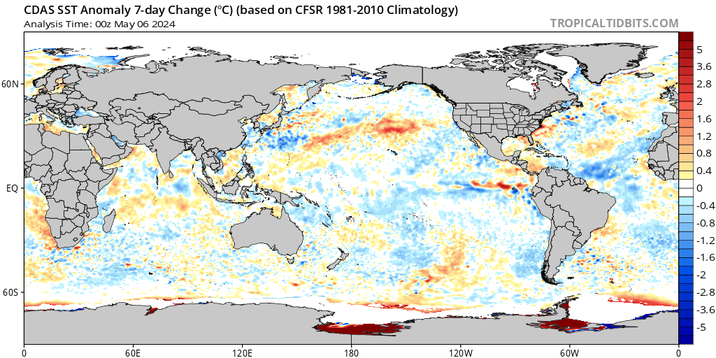
Recall this: The SSTA as of Nov 12th
Now look at the curent SSTA:

The reason this may be significant is the strongest SST gradient may shift now from the N Central Pac like it has been, to the NE Pac now enhancing the -EPO ridge formation(A more classic +PDO setup) making the -EPO an actual real LR projection, rather than a fantasy LR projection. We shall see though. I am still skeptical, but if true the invasion of the Siberian/arctic air masses into NA, beginning with Canada and the Western CONUS will commence as we head into the first week of Dec.
Wild Cards: We will have to see how the MJO behaves and how the Nina forcings behave as they could be factors that mute the potential pole ward -EPO blocking influences esp if they work together. In addition a "west based" -EPO may play a role in keeping the coldest air in the west. The stratosphere may play a role beyond day 10, however, its influences will likely not be known for some time. There will likely not be any major changes to the strat and its influences on us for at least the next 10days.
_________________
"In weather and in life, there's no winning and losing; there's only winning and learning."
WINTER 2012/2013 TOTALS 43.65"WINTER 2017/2018 TOTALS 62.85" WINTER 2022/2023 TOTALS 4.9"
WINTER 2013/2014 TOTALS 64.85"WINTER 2018/2019 TOTALS 14.25" WINTER 2023/2024 TOTALS 13.1"
WINTER 2014/2015 TOTALS 71.20"WINTER 2019/2020 TOTALS 6.35"
WINTER 2015/2016 TOTALS 35.00"WINTER 2020/2021 TOTALS 37.75"
WINTER 2016/2017 TOTALS 42.25"WINTER 2021/2022 TOTALS 31.65"
sroc4- Admin
- Posts : 8331
Reputation : 301
Join date : 2013-01-07
Location : Wading River, LI
Re: Long Range Thread 12.0
![]() by Frank_Wx Sun Nov 27, 2016 10:12 am
by Frank_Wx Sun Nov 27, 2016 10:12 am
_________________
_______________________________________________________________________________________________________
CLICK HERE to view NJ Strong Snowstorm Classifications
Frank_Wx- Godzilla Seeker
- Posts : 21305
Reputation : 328
Join date : 2013-01-05
Age : 31
Location : Jersey City, NJ -
Page 24 of 40 • 1 ... 13 ... 23, 24, 25 ... 32 ... 40 ![]()
|
|
|