
 Search
January 7, 2017 Storm Observations
Page 19 of 24 •  1 ... 11 ... 18, 19, 20 ... 24
 ![]()

Frank_Wx- Godzilla Seeker

- Posts : 21305
Join date : 2013-01-05 -

Re: January 7, 2017 Storm Observations
![]() by billg315 Sat Jan 07, 2017 2:54 pm
by billg315 Sat Jan 07, 2017 2:54 pm
billg315- Advanced Forecaster - Mod

- Posts : 4462
Join date : 2015-01-24
Re: January 7, 2017 Storm Observations
![]() by Frank_Wx Sat Jan 07, 2017 2:54 pm
by Frank_Wx Sat Jan 07, 2017 2:54 pm

_________________
_______________________________________________________________________________________________________
CLICK HERE to view NJ Strong Snowstorm Classifications

Frank_Wx- Godzilla Seeker
- Posts : 21305
Reputation : 328
Join date : 2013-01-05
Age : 31
Location : Jersey City, NJ -
Re: January 7, 2017 Storm Observations
![]() by Guest Sat Jan 07, 2017 2:54 pm
by Guest Sat Jan 07, 2017 2:54 pm
Guest- Guest
Re: January 7, 2017 Storm Observations
![]() by Frank_Wx Sat Jan 07, 2017 2:55 pm
by Frank_Wx Sat Jan 07, 2017 2:55 pm
_________________
_______________________________________________________________________________________________________
CLICK HERE to view NJ Strong Snowstorm Classifications
Frank_Wx- Godzilla Seeker
- Posts : 21305
Reputation : 328
Join date : 2013-01-05
Age : 31
Location : Jersey City, NJ -
Re: January 7, 2017 Storm Observations
![]() by aiannone Sat Jan 07, 2017 2:55 pm
by aiannone Sat Jan 07, 2017 2:55 pm
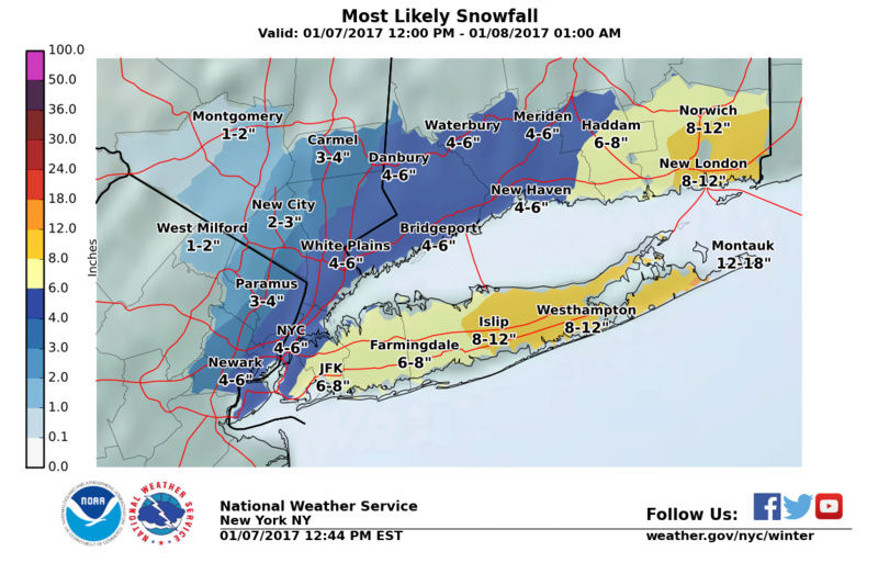
12-18 line made it to montauk
_________________
-Alex Iannone-

aiannone- Senior Enthusiast - Mod
- Posts : 4813
Reputation : 92
Join date : 2013-01-07
Location : Saint James, LI (Northwest Suffolk Co.)
Re: January 7, 2017 Storm Observations
![]() by Frank_Wx Sat Jan 07, 2017 2:55 pm
by Frank_Wx Sat Jan 07, 2017 2:55 pm

_________________
_______________________________________________________________________________________________________
CLICK HERE to view NJ Strong Snowstorm Classifications
Frank_Wx- Godzilla Seeker
- Posts : 21305
Reputation : 328
Join date : 2013-01-05
Age : 31
Location : Jersey City, NJ -
Re: January 7, 2017 Storm Observations
![]() by Frank_Wx Sat Jan 07, 2017 2:56 pm
by Frank_Wx Sat Jan 07, 2017 2:56 pm

_________________
_______________________________________________________________________________________________________
CLICK HERE to view NJ Strong Snowstorm Classifications
Frank_Wx- Godzilla Seeker
- Posts : 21305
Reputation : 328
Join date : 2013-01-05
Age : 31
Location : Jersey City, NJ -
Re: January 7, 2017 Storm Observations
![]() by Frank_Wx Sat Jan 07, 2017 2:58 pm
by Frank_Wx Sat Jan 07, 2017 2:58 pm

_________________
_______________________________________________________________________________________________________
CLICK HERE to view NJ Strong Snowstorm Classifications
Frank_Wx- Godzilla Seeker
- Posts : 21305
Reputation : 328
Join date : 2013-01-05
Age : 31
Location : Jersey City, NJ -
Re: January 7, 2017 Storm Observations
![]() by Guest Sat Jan 07, 2017 2:58 pm
by Guest Sat Jan 07, 2017 2:58 pm
Frank_Wx wrote:Wow
By the time that band rotates through here I should be close to 6". If it holds together we could be at 8" here in Nassau county by the time it's over
Guest- Guest
Re: January 7, 2017 Storm Observations
![]() by Math23x7 Sat Jan 07, 2017 3:02 pm
by Math23x7 Sat Jan 07, 2017 3:02 pm
Last edited by Math23x7 on Sat Jan 07, 2017 3:03 pm; edited 1 time in total
Math23x7- Wx Statistician Guru

- Posts : 2379
Reputation : 68
Join date : 2013-01-08
Re: January 7, 2017 Storm Observations
![]() by aiannone Sat Jan 07, 2017 3:02 pm
by aiannone Sat Jan 07, 2017 3:02 pm
_________________
-Alex Iannone-
aiannone- Senior Enthusiast - Mod
- Posts : 4813
Reputation : 92
Join date : 2013-01-07
Location : Saint James, LI (Northwest Suffolk Co.)
Re: January 7, 2017 Storm Observations
![]() by crippo84 Sat Jan 07, 2017 3:02 pm
by crippo84 Sat Jan 07, 2017 3:02 pm

crippo84- Posts : 383
Reputation : 20
Join date : 2013-11-07
Age : 40
Location : East Village, NYC
Re: January 7, 2017 Storm Observations
![]() by lglickman Sat Jan 07, 2017 3:02 pm
by lglickman Sat Jan 07, 2017 3:02 pm
lglickman- Posts : 8
Reputation : 0
Join date : 2013-02-11
Re: January 7, 2017 Storm Observations
![]() by aiannone Sat Jan 07, 2017 3:06 pm
by aiannone Sat Jan 07, 2017 3:06 pm
_________________
-Alex Iannone-
aiannone- Senior Enthusiast - Mod
- Posts : 4813
Reputation : 92
Join date : 2013-01-07
Location : Saint James, LI (Northwest Suffolk Co.)
Re: January 7, 2017 Storm Observations
![]() by Fededle22 Sat Jan 07, 2017 3:07 pm
by Fededle22 Sat Jan 07, 2017 3:07 pm

Fededle22- Posts : 169
Reputation : 2
Join date : 2013-03-08
Location : West Orange, NJ
Re: January 7, 2017 Storm Observations
![]() by Frank_Wx Sat Jan 07, 2017 3:07 pm
by Frank_Wx Sat Jan 07, 2017 3:07 pm
.gif.ce039840aa4e7c55ab81ae2a2e955da0.gif)
_________________
_______________________________________________________________________________________________________
CLICK HERE to view NJ Strong Snowstorm Classifications
Frank_Wx- Godzilla Seeker
- Posts : 21305
Reputation : 328
Join date : 2013-01-05
Age : 31
Location : Jersey City, NJ -
Re: January 7, 2017 Storm Observations
![]() by Frank_Wx Sat Jan 07, 2017 3:07 pm
by Frank_Wx Sat Jan 07, 2017 3:07 pm
Fededle22 wrote:Too bad this storm just can't stall and rotate moisture from the gulf inland. Any blocking to the North?
Nope. We have not seen a true -NAO since 2010.
_________________
_______________________________________________________________________________________________________
CLICK HERE to view NJ Strong Snowstorm Classifications
Frank_Wx- Godzilla Seeker
- Posts : 21305
Reputation : 328
Join date : 2013-01-05
Age : 31
Location : Jersey City, NJ -
Re: January 7, 2017 Storm Observations
![]() by jmanley32 Sat Jan 07, 2017 3:09 pm
by jmanley32 Sat Jan 07, 2017 3:09 pm

jmanley32- Senior Enthusiast

- Posts : 20513
Reputation : 108
Join date : 2013-12-12
Age : 42
Location : Yonkers, NY
Re: January 7, 2017 Storm Observations
![]() by Biggin23 Sat Jan 07, 2017 3:14 pm
by Biggin23 Sat Jan 07, 2017 3:14 pm
Biggin23- Posts : 259
Reputation : 0
Join date : 2015-02-11
Location : Jackson, NJ
Re: January 7, 2017 Storm Observations
![]() by aiannone Sat Jan 07, 2017 3:15 pm
by aiannone Sat Jan 07, 2017 3:15 pm
...SNOW ENDS THIS EVENING...HEAVIEST TOTALS ACROSS LONG ISLAND
AND SOUTHEAST CONNECTICUT...
CTZ007-008-011-012-NYZ078>081-080500-
/O.CON.KOKX.WS.W.0001.000000T0000Z-170108T0500Z/
NORTHERN MIDDLESEX-NORTHERN NEW LONDON-SOUTHERN MIDDLESEX-
SOUTHERN NEW LONDON-NORTHWESTERN SUFFOLK-NORTHEASTERN SUFFOLK-
SOUTHWESTERN SUFFOLK-SOUTHEASTERN SUFFOLK-
257 PM EST SAT JAN 7 2017
...WINTER STORM WARNING REMAINS IN EFFECT UNTIL MIDNIGHT EST
TONIGHT...
* LOCATIONS...NEW LONDON COUNTY IN CONNECTICUT AND SUFFOLK
COUNTY IN NEW YORK.
* HAZARD TYPES...HEAVY SNOW. AREAS OF BLOWING SNOW.
* TOTAL SNOW ACCUMULATIONS...8 TO 12 INCHES. AREAS OF OVER A FOOT
ON THE SOUTH FORK OF LONG ISLAND ARE LIKELY.
* VISIBILITIES...ONE QUARTER MILE OR LESS AT TIMES.
* TIMING...HEAVILY INTO EARLY THIS AFTERNOON...THEN TAPERING OFF BY
MIDNIGHT.
* WINDS...NORTH 10 TO 20 MPH WITH GUSTS UP TO 30 MPH.
* TEMPERATURES...IN THE LOWER 20S.
* IMPACTS...HAZARDOUS TRAVEL DUE TO SNOW COVERED ROADS AND
REDUCED VISIBILITIES.
_________________
-Alex Iannone-
aiannone- Senior Enthusiast - Mod
- Posts : 4813
Reputation : 92
Join date : 2013-01-07
Location : Saint James, LI (Northwest Suffolk Co.)
Re: January 7, 2017 Storm Observations
![]() by Frank_Wx Sat Jan 07, 2017 3:15 pm
by Frank_Wx Sat Jan 07, 2017 3:15 pm

_________________
_______________________________________________________________________________________________________
CLICK HERE to view NJ Strong Snowstorm Classifications
Frank_Wx- Godzilla Seeker
- Posts : 21305
Reputation : 328
Join date : 2013-01-05
Age : 31
Location : Jersey City, NJ -
Re: January 7, 2017 Storm Observations
![]() by Frank_Wx Sat Jan 07, 2017 3:16 pm
by Frank_Wx Sat Jan 07, 2017 3:16 pm

_________________
_______________________________________________________________________________________________________
CLICK HERE to view NJ Strong Snowstorm Classifications
Frank_Wx- Godzilla Seeker
- Posts : 21305
Reputation : 328
Join date : 2013-01-05
Age : 31
Location : Jersey City, NJ -
Re: January 7, 2017 Storm Observations
![]() by aiannone Sat Jan 07, 2017 3:18 pm
by aiannone Sat Jan 07, 2017 3:18 pm

_________________
-Alex Iannone-
aiannone- Senior Enthusiast - Mod
- Posts : 4813
Reputation : 92
Join date : 2013-01-07
Location : Saint James, LI (Northwest Suffolk Co.)

bloc1357- Pro Enthusiast

- Posts : 344
Reputation : 10
Join date : 2013-03-05
Age : 47
Location : West Babylon, NY - 11704
Re: January 7, 2017 Storm Observations
![]() by Dtone Sat Jan 07, 2017 3:24 pm
by Dtone Sat Jan 07, 2017 3:24 pm
Hard to measure with the wind but a little over 3" now.
Dtone- Wx Statistician Guru
- Posts : 1738
Reputation : 9
Join date : 2013-08-26
Location : Bronx, NY
Re: January 7, 2017 Storm Observations
![]() by SoulSingMG Sat Jan 07, 2017 3:25 pm
by SoulSingMG Sat Jan 07, 2017 3:25 pm
Frank_Wx wrote:
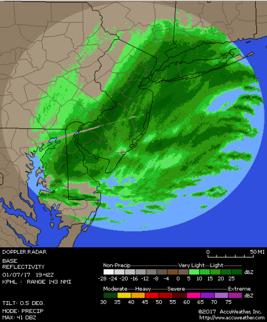
Look at that backbuilding!

SoulSingMG- Senior Enthusiast
- Posts : 2853
Reputation : 74
Join date : 2013-12-11
Location : Long Island City, NY
Page 19 of 24 • 1 ... 11 ... 18, 19, 20 ... 24 ![]()
|
|
|