
 Search
March Madness! Spring Snowstorm Observations
Page 13 of 40 •  1 ... 8 ... 12, 13, 14 ... 26 ... 40
 ![]()

Sanchize06- Senior Enthusiast

- Posts : 1041
Join date : 2013-02-05
Re: March Madness! Spring Snowstorm Observations
![]() by Frank_Wx Tue Mar 20, 2018 5:28 pm
by Frank_Wx Tue Mar 20, 2018 5:28 pm
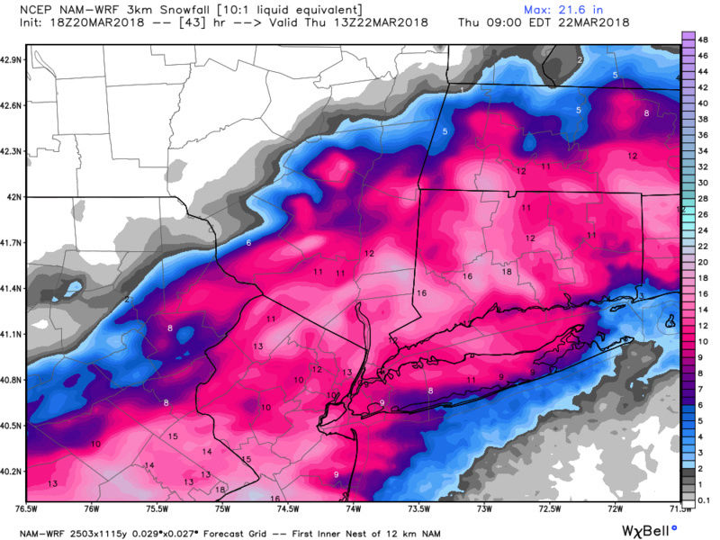
The following is stated with a request to please check back on
our 4 AM products tomorrow morning. But as of this writing...we
continue to need to sound the siren for major or extreme impact
for the I95 corridor to I80 Wednesday afternoon and night.
Major and dangerous probable record breaking March winter snow
storm (pasting!) for both the 2 day total and the month of
March for parts of our area (NNJ for the month, PHL the storm)
with impassable roads expected and possibly the greatest number
of power outages from any storm so far in March. This continues
to look HUGE and potential extreme impact I95 corridor up to
I80.
Take this storm seriously and prepare for changing your daily
plans, especially Wednesday. Unnecessary travel is not recommended
Wednesday in eastern PA and the northwest two thirds of NJ. It
could be life threatening if disabled in rural areas. If you
have to travel, plan for much much longer commutes. Potential
exists widespread cancellations in eastern PA and much of nw NJ.
This forecast today was split between myself Wednesday through
Friday, and Lance, Friday night through the weekend.
Growing 12z/20 model consensus (exception the seemingly lagging
op 12z/20 ECMWF?) with heavy reliance on the NAM 12 and 3KM as
well as the bountiful model qpf from the RGEM/GGEM, UKMET.
We expect widespread 1 to 3 inches of qpf from this, heaviest se
PA thru northern and central NJ, Banding will be a huge
contributor. The northwest fringe of our area from KMPO to High
Point may escape with only 6 to 10 inches of snow but it is now
expected that widespread storm totals 10-20" will occur I95
corridor nwwd with isolated 25 inch amounts possible some where
between I95 and and I80...probably best chance hilly areas of
northern NJ where some 30 inches has already occurred this
month.
The forecast snow total map includes todays sleet/snow mix and
the anticipated much greater snowfall on Wednesday. Please
realize that pavement amounts will be considerably less but we
expect at least 7 inches on all pavements in NJ/e PA from this
storm as a minimum and at least 3" pavements elsewhere to the se
of I95. We forecast for the traditional accumulating surfaces
including homes/trees/wires and that is what will cause the
power outages...ie 6" or more of wet snow (32-33F) should
trigger a sharp increase in power outages Wednesday afternoon.
Also wind driven wet snow or freezing rain clinging to branches
and wires will be part of the power outage problem. Our forecast
amounts are presented on our winter wx page and social media
briefing packages serves as a good start! Have been
uncomfortable forecasting these amounts the past two days in our
area, late season and what not, but the recent advances in
modeling and snow forecasting science tells us these amounts
are probable including running qpf from snow ratios.
Wednesday and Wednesday night through 2 am Thursday...By 00z/22
(Wednesday evening), our forecast area will have been in
constant 3 to 4 standard deviation 850MB easterly flow with
pretty high values of moisture flux for 24hours!!, beginning
late this afternoon and continuing through Wednesday afternoon.
This less extreme easterly flow inflow might normally mean less
qpf, but the unusually long duration has to make up for the
normally faster newd movement of the 850MB ely inflow. I think
this justifies the NAM and GGEM QPF and resultant excessive late
season snowfall.
As the 500 mb associated heights lower, whatever remains of the
remaining above freezing 880-800MB layer is cooled to freezing
around 12z/Wednesday along and nw of I95, and any mixed
precipitation will change to snow. (We think the NAM warm nose
is a bit overdone but respect it becoming more pronounced this
evening before cooling tomorrow morning).
Bands of cirrus will increase the seeding potential (potential
thunder snow) and there is considerable agreement that FGEN
banding will develop on the northwest periphery of the deepening
mid Atlc coast cyclone. That will mean 1-3"/hr accumulations at
times Wednesday afternoon and evening, especially I95 westward.
This with snow water ratios of 11 or 12 to 1 e PA and nNJ (near
9 or 10 to 1 I95 should result in record breaking (see climate
section). If thunderstorms occur (we saw lightning in clouds in
nw VA and around 11z and recently se of DC around 1320z), then
we may have a repeat of 3-4" hr snowfall rates. There is still
uncertainty on whether thunder will occur.
Strong winds, with gusts around 45 mph, primarily along the coast,
and primarily during the morning. This will could cause power
problems, especially if there is already a snow load on trees
and power lines. The strongest winds may occur before the heaviest
snow, although that is still somewhat uncertain. I also don`t
think these strong winds will contribute too much to blowing
snow prior to the evening commute. This will be a very heavy
wet snow which should limit the blowing snow threat until
sundown Wednesday. For now consider this heart attack - power
outage snow, pasted street signs.
Late Wednesday night after 2 am Thursday...snow tapering off
late with gusty northwest winds to 25 MPH.
Frank_Wx- Godzilla Seeker

- Posts : 21305
Join date : 2013-01-05 -

Re: March Madness! Spring Snowstorm Observations
![]() by bloc1357 Tue Mar 20, 2018 5:29 pm
by bloc1357 Tue Mar 20, 2018 5:29 pm
jmanley32 wrote:The lowered totals? Thats odd, by 2 inches for all numbers noted.SoulSingMG wrote:UPTON'S latest:

maybe for your area...but they raised them for LI.
bloc1357- Pro Enthusiast

- Posts : 344
Reputation : 10
Join date : 2013-03-05
Age : 47
Location : West Babylon, NY - 11704
Re: March Madness! Spring Snowstorm Observations
![]() by aiannone Tue Mar 20, 2018 5:31 pm
by aiannone Tue Mar 20, 2018 5:31 pm
_________________
-Alex Iannone-

aiannone- Senior Enthusiast - Mod

- Posts : 4813
Reputation : 92
Join date : 2013-01-07
Location : Saint James, LI (Northwest Suffolk Co.)
Re: March Madness! Spring Snowstorm Observations
![]() by frank 638 Tue Mar 20, 2018 5:31 pm
by frank 638 Tue Mar 20, 2018 5:31 pm
frank 638- Senior Enthusiast
- Posts : 2824
Reputation : 37
Join date : 2016-01-01
Age : 40
Location : bronx ny
Re: March Madness! Spring Snowstorm Observations
![]() by hurrysundown23 Tue Mar 20, 2018 5:32 pm
by hurrysundown23 Tue Mar 20, 2018 5:32 pm
NJZ009-010-012>015-210930-
/O.CON.KPHI.WS.W.0007.180320T2200Z-180322T0600Z/
Hunterdon-Somerset-Middlesex-Western Monmouth-Eastern Monmouth-
Mercer-
Including the cities of Flemington, Somerville, New Brunswick,
Freehold, Sandy Hook, and Trenton
356 PM EDT Tue Mar 20 2018
...WINTER STORM WARNING REMAINS IN EFFECT UNTIL 2 AM EDT
THURSDAY...
* WHAT...Heavy snow expected. Total snow accumulations of 13 to
17 inches are expected.
* WHERE...Portions of central, northern and northwest New Jersey.
* WHEN...Until 2 AM EDT Thursday.
* ADDITIONAL DETAILS...Travel will be very difficult to impossible
Wednesday afternoon and evening, including during the evening
commute on Wednesday. Snowfall rates of 1 to 2 inches per hour
are expected at times Wednesday afternoon and evening when
visibility will be reduced to less than half a mile. Power
outages may develop from snow loads Wednesday afternoon and
there may be some thunder snow. Highest accumulations will be in
the hilly areas. In the meantime, the mixed bag of wintry
precipitation may let up or change to light freezing rain or
rain later this evening before a change to snow Wednesday
morning. Blowing snow is possible on Thursday.
hurrysundown23- Posts : 53
Reputation : 1
Join date : 2017-01-04
Location : Sayreville, NJ
Re: March Madness! Spring Snowstorm Observations
![]() by SkiSeadooJoe Tue Mar 20, 2018 5:33 pm
by SkiSeadooJoe Tue Mar 20, 2018 5:33 pm


SkiSeadooJoe- Posts : 89
Reputation : 8
Join date : 2013-01-08
Age : 51
Location : Toms River, NJ
Re: March Madness! Spring Snowstorm Observations
![]() by skinsfan1177 Tue Mar 20, 2018 5:35 pm
by skinsfan1177 Tue Mar 20, 2018 5:35 pm

skinsfan1177- Senior Enthusiast
- Posts : 4485
Reputation : 35
Join date : 2013-01-07
Age : 46
Location : Point Pleasant Boro
Re: March Madness! Spring Snowstorm Observations
![]() by jmanley32 Tue Mar 20, 2018 5:36 pm
by jmanley32 Tue Mar 20, 2018 5:36 pm
Why is NJ taking this so much more seriously than Upton? Arent we in for pretty much similar wet snow wind/power outage impacts? If not whats the difference?Frank_Wx wrote:LONG TERM /WEDNESDAY THROUGH TUESDAY/...
The following is stated with a request to please check back on
our 4 AM products tomorrow morning. But as of this writing...we
continue to need to sound the siren for major or extreme impact
for the I95 corridor to I80 Wednesday afternoon and night.
Major and dangerous probable record breaking March winter snow
storm (pasting!) for both the 2 day total and the month of
March for parts of our area (NNJ for the month, PHL the storm)
with impassable roads expected and possibly the greatest number
of power outages from any storm so far in March. This continues
to look HUGE and potential extreme impact I95 corridor up to
I80.
Take this storm seriously and prepare for changing your daily
plans, especially Wednesday. Unnecessary travel is not recommended
Wednesday in eastern PA and the northwest two thirds of NJ. It
could be life threatening if disabled in rural areas. If you
have to travel, plan for much much longer commutes. Potential
exists widespread cancellations in eastern PA and much of nw NJ.
This forecast today was split between myself Wednesday through
Friday, and Lance, Friday night through the weekend.
Growing 12z/20 model consensus (exception the seemingly lagging
op 12z/20 ECMWF?) with heavy reliance on the NAM 12 and 3KM as
well as the bountiful model qpf from the RGEM/GGEM, UKMET.
We expect widespread 1 to 3 inches of qpf from this, heaviest se
PA thru northern and central NJ, Banding will be a huge
contributor. The northwest fringe of our area from KMPO to High
Point may escape with only 6 to 10 inches of snow but it is now
expected that widespread storm totals 10-20" will occur I95
corridor nwwd with isolated 25 inch amounts possible some where
between I95 and and I80...probably best chance hilly areas of
northern NJ where some 30 inches has already occurred this
month.
The forecast snow total map includes todays sleet/snow mix and
the anticipated much greater snowfall on Wednesday. Please
realize that pavement amounts will be considerably less but we
expect at least 7 inches on all pavements in NJ/e PA from this
storm as a minimum and at least 3" pavements elsewhere to the se
of I95. We forecast for the traditional accumulating surfaces
including homes/trees/wires and that is what will cause the
power outages...ie 6" or more of wet snow (32-33F) should
trigger a sharp increase in power outages Wednesday afternoon.
Also wind driven wet snow or freezing rain clinging to branches
and wires will be part of the power outage problem. Our forecast
amounts are presented on our winter wx page and social media
briefing packages serves as a good start! Have been
uncomfortable forecasting these amounts the past two days in our
area, late season and what not, but the recent advances in
modeling and snow forecasting science tells us these amounts
are probable including running qpf from snow ratios.
Wednesday and Wednesday night through 2 am Thursday...By 00z/22
(Wednesday evening), our forecast area will have been in
constant 3 to 4 standard deviation 850MB easterly flow with
pretty high values of moisture flux for 24hours!!, beginning
late this afternoon and continuing through Wednesday afternoon.
This less extreme easterly flow inflow might normally mean less
qpf, but the unusually long duration has to make up for the
normally faster newd movement of the 850MB ely inflow. I think
this justifies the NAM and GGEM QPF and resultant excessive late
season snowfall.
As the 500 mb associated heights lower, whatever remains of the
remaining above freezing 880-800MB layer is cooled to freezing
around 12z/Wednesday along and nw of I95, and any mixed
precipitation will change to snow. (We think the NAM warm nose
is a bit overdone but respect it becoming more pronounced this
evening before cooling tomorrow morning).
Bands of cirrus will increase the seeding potential (potential
thunder snow) and there is considerable agreement that FGEN
banding will develop on the northwest periphery of the deepening
mid Atlc coast cyclone. That will mean 1-3"/hr accumulations at
times Wednesday afternoon and evening, especially I95 westward.
This with snow water ratios of 11 or 12 to 1 e PA and nNJ (near
9 or 10 to 1 I95 should result in record breaking (see climate
section). If thunderstorms occur (we saw lightning in clouds in
nw VA and around 11z and recently se of DC around 1320z), then
we may have a repeat of 3-4" hr snowfall rates. There is still
uncertainty on whether thunder will occur.
Strong winds, with gusts around 45 mph, primarily along the coast,
and primarily during the morning. This will could cause power
problems, especially if there is already a snow load on trees
and power lines. The strongest winds may occur before the heaviest
snow, although that is still somewhat uncertain. I also don`t
think these strong winds will contribute too much to blowing
snow prior to the evening commute. This will be a very heavy
wet snow which should limit the blowing snow threat until
sundown Wednesday. For now consider this heart attack - power
outage snow, pasted street signs.
Late Wednesday night after 2 am Thursday...snow tapering off
late with gusty northwest winds to 25 MPH.

jmanley32- Senior Enthusiast
- Posts : 20513
Reputation : 108
Join date : 2013-12-12
Age : 42
Location : Yonkers, NY
Re: March Madness! Spring Snowstorm Observations
![]() by CPcantmeasuresnow Tue Mar 20, 2018 5:38 pm
by CPcantmeasuresnow Tue Mar 20, 2018 5:38 pm
syosnow94 wrote:Mask CP. he knowsjmanley32 wrote:Do not understand why 3km is so much lower than the 12km, usually its much higher, I will take the 12km lol, of course I would still be happy with this too, but sorry gonna get greedy on this one its our only shot.


CPcantmeasuresnow- Wx Statistician Guru

- Posts : 7274
Reputation : 230
Join date : 2013-01-07
Age : 103
Location : Eastern Orange County, NY
Re: March Madness! Spring Snowstorm Observations
![]() by skinsfan1177 Tue Mar 20, 2018 5:39 pm
by skinsfan1177 Tue Mar 20, 2018 5:39 pm
skinsfan1177- Senior Enthusiast
- Posts : 4485
Reputation : 35
Join date : 2013-01-07
Age : 46
Location : Point Pleasant Boro
Re: March Madness! Spring Snowstorm Observations
![]() by nutleyblizzard Tue Mar 20, 2018 5:40 pm
by nutleyblizzard Tue Mar 20, 2018 5:40 pm

nutleyblizzard- Senior Enthusiast
- Posts : 1952
Reputation : 41
Join date : 2014-01-30
Age : 58
Location : Nutley, new jersey
Re: March Madness! Spring Snowstorm Observations
![]() by Guest Tue Mar 20, 2018 5:41 pm
by Guest Tue Mar 20, 2018 5:41 pm
Guest- Guest
Re: March Madness! Spring Snowstorm Observations
![]() by RJB8525 Tue Mar 20, 2018 5:41 pm
by RJB8525 Tue Mar 20, 2018 5:41 pm

RJB8525- Senior Enthusiast
- Posts : 1994
Reputation : 28
Join date : 2013-02-06
Age : 38
Location : Hackettstown, NJ
Re: March Madness! Spring Snowstorm Observations
![]() by nutleyblizzard Tue Mar 20, 2018 5:41 pm
by nutleyblizzard Tue Mar 20, 2018 5:41 pm
nutleyblizzard- Senior Enthusiast
- Posts : 1952
Reputation : 41
Join date : 2014-01-30
Age : 58
Location : Nutley, new jersey
Re: March Madness! Spring Snowstorm Observations
![]() by Sanchize06 Tue Mar 20, 2018 5:41 pm
by Sanchize06 Tue Mar 20, 2018 5:41 pm
Sanchize06- Senior Enthusiast
- Posts : 1041
Reputation : 21
Join date : 2013-02-05
Location : Union Beach, NJ
Re: March Madness! Spring Snowstorm Observations
![]() by jmanley32 Tue Mar 20, 2018 5:42 pm
by jmanley32 Tue Mar 20, 2018 5:42 pm
https://www.weather.gov/media/okx/Briefings/2018-03-20%20Winter%20Storm_430pm_external.pdf
jmanley32- Senior Enthusiast
- Posts : 20513
Reputation : 108
Join date : 2013-12-12
Age : 42
Location : Yonkers, NY
Re: March Madness! Spring Snowstorm Observations
![]() by Frank_Wx Tue Mar 20, 2018 5:42 pm
by Frank_Wx Tue Mar 20, 2018 5:42 pm
_________________
_______________________________________________________________________________________________________
CLICK HERE to view NJ Strong Snowstorm Classifications

Frank_Wx- Godzilla Seeker
- Posts : 21305
Reputation : 328
Join date : 2013-01-05
Age : 31
Location : Jersey City, NJ -
Re: March Madness! Spring Snowstorm Observations
![]() by CPcantmeasuresnow Tue Mar 20, 2018 5:42 pm
by CPcantmeasuresnow Tue Mar 20, 2018 5:42 pm
frank 638 wrote:I wonder if the idiot mayor will close the city school tomorrow
He might, but even if he does he will still be an idiot.
Sorry, I meant with all due respect he will still be an idiot.
CPcantmeasuresnow- Wx Statistician Guru
- Posts : 7274
Reputation : 230
Join date : 2013-01-07
Age : 103
Location : Eastern Orange County, NY
Re: March Madness! Spring Snowstorm Observations
![]() by Frank_Wx Tue Mar 20, 2018 5:43 pm
by Frank_Wx Tue Mar 20, 2018 5:43 pm
_________________
_______________________________________________________________________________________________________
CLICK HERE to view NJ Strong Snowstorm Classifications
Frank_Wx- Godzilla Seeker
- Posts : 21305
Reputation : 328
Join date : 2013-01-05
Age : 31
Location : Jersey City, NJ -
Re: March Madness! Spring Snowstorm Observations
![]() by nujerzeedevil Tue Mar 20, 2018 5:43 pm
by nujerzeedevil Tue Mar 20, 2018 5:43 pm

nujerzeedevil- Posts : 121
Reputation : 14
Join date : 2013-12-30
Location : Bayville, NJ
Re: March Madness! Spring Snowstorm Observations
![]() by nujerzeedevil Tue Mar 20, 2018 5:45 pm
by nujerzeedevil Tue Mar 20, 2018 5:45 pm
skinsfan1177 wrote:This is insane wasn't even suppose to snow much here today
Puking snow on the Parkway skins....
nujerzeedevil- Posts : 121
Reputation : 14
Join date : 2013-12-30
Location : Bayville, NJ
Re: March Madness! Spring Snowstorm Observations
![]() by Quietace Tue Mar 20, 2018 5:45 pm
by Quietace Tue Mar 20, 2018 5:45 pm

Quietace- Meteorologist - Mod

- Posts : 3687
Reputation : 33
Join date : 2013-01-07
Age : 27
Location : Point Pleasant, NJ
Re: March Madness! Spring Snowstorm Observations
![]() by Smittyaj623 Tue Mar 20, 2018 5:46 pm
by Smittyaj623 Tue Mar 20, 2018 5:46 pm
Smittyaj623- Posts : 73
Reputation : 6
Join date : 2018-03-06
Age : 23
Location : Bayville, NJ
Re: March Madness! Spring Snowstorm Observations
![]() by CPcantmeasuresnow Tue Mar 20, 2018 5:48 pm
by CPcantmeasuresnow Tue Mar 20, 2018 5:48 pm
Smittyaj623 wrote:This is about to be a big one...I gotta feeling for us Coasties
Hope so, you've earned it, enjoy.
CPcantmeasuresnow- Wx Statistician Guru
- Posts : 7274
Reputation : 230
Join date : 2013-01-07
Age : 103
Location : Eastern Orange County, NY
Re: March Madness! Spring Snowstorm Observations
![]() by mwilli5783 Tue Mar 20, 2018 5:48 pm
by mwilli5783 Tue Mar 20, 2018 5:48 pm
mwilli5783- Posts : 146
Reputation : 9
Join date : 2013-01-23
Age : 69
Location : hempstead n.y
Page 13 of 40 • 1 ... 8 ... 12, 13, 14 ... 26 ... 40 ![]()
|
|
|