
 Search
March Madness! Spring Snowstorm Observations
Page 26 of 40 •  1 ... 14 ... 25, 26, 27 ... 33 ... 40
 ![]()
Re: March Madness! Spring Snowstorm Observations
![]() by nutleyblizzard Wed Mar 21, 2018 5:11 am
by nutleyblizzard Wed Mar 21, 2018 5:11 am
They are probably looking at current observations and upper levels. Read RB's post.jmanley32 wrote:The models I no likey 10 inches on nam that's low for what's being forecasted , and heard euro was really bad? Where is nws get these high numbers from?
nutleyblizzard- Senior Enthusiast

- Posts : 1952
Join date : 2014-01-30
Re: March Madness! Spring Snowstorm Observations
![]() by RJB8525 Wed Mar 21, 2018 5:20 am
by RJB8525 Wed Mar 21, 2018 5:20 am
RJB8525- Senior Enthusiast
- Posts : 1994
Join date : 2013-02-06
Re: March Madness! Spring Snowstorm Observations
![]() by SoulSingMG Wed Mar 21, 2018 5:25 am
by SoulSingMG Wed Mar 21, 2018 5:25 am
rb924119 wrote:Everybody needs to calm down lol based on my observations from yesterday (posted somewhere amongst these threads) I see no reason to panic, as my present analysis of radar, WV, and current conditions seem to support them strongly still. The HRRR looks good to me overall, though I think ALL modeling is still largely undergoing the northwestern progression of the precipitation shield, which is already well north and west of suites like the EURO. The orientation of our parent mid-level lows, WHICH ARE STILL IN THE OHIO VALLEY, argues for the northwestern extent of the current banding on radar to continue pressing northwestward for a while before halting progression. Northern Wayne county into Susquehanna County Pa seems like a decent pivot point for the back edge of precip that orients at a ~"7-2" angle (referencing a clock). Once that happens, expect precip to begin filling in to its southeast as the mid-level systems begin their incremental eastward progression during the day, and bring strong forcing with them. What we are seeing right now is forcing being created by diffluent/divergent flow aloft in the pva region downstream of large scale trough axis. No other true dynamics are really being tapped yet so what we are seeing right is a bonus. The mean flow is continuing to back, and is now being directed with a partial easterly component, which will further increase moisture transport and thermal advections as time goes. Give it time, folks.
Additionally, my analysis of WV imagery leads me to believe that our parent mid-level lows have gained a little more latitude than what guidance was suggesting which bodes well for us. Instead of exiting off of Virginia's latitude it would seem that the Delmarva would make more sense here, which is PERFECT FOR NEARLY ALL OF OUR FORUM. TRUST EYES NOT MODELS. MODELS HAVE BEEN USELESS SINCE LAST NIGHT. Back to bed now lol
Without a doubt my favorite post of yours of all time. Bed for me now as well (nothing to see here until we start cranking late afternoon)


SoulSingMG- Senior Enthusiast
- Posts : 2853
Reputation : 74
Join date : 2013-12-11
Location : Long Island City, NY
Re: March Madness! Spring Snowstorm Observations
![]() by SoulSingMG Wed Mar 21, 2018 5:27 am
by SoulSingMG Wed Mar 21, 2018 5:27 am

G'night/morning.
SoulSingMG- Senior Enthusiast
- Posts : 2853
Reputation : 74
Join date : 2013-12-11
Location : Long Island City, NY
Re: March Madness! Spring Snowstorm Observations
![]() by heehaw453 Wed Mar 21, 2018 5:32 am
by heehaw453 Wed Mar 21, 2018 5:32 am
LETS GO!!!
heehaw453- Advanced Forecaster

- Posts : 3906
Reputation : 86
Join date : 2014-01-20
Location : Bedminster Township, PA Elevation 600' ASL
Re: March Madness! Spring Snowstorm Observations
![]() by aiannone Wed Mar 21, 2018 5:40 am
by aiannone Wed Mar 21, 2018 5:40 am
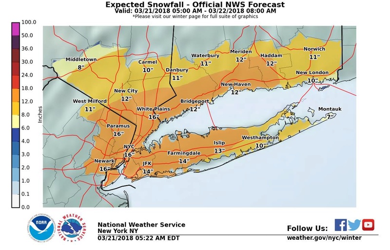
Colder and
drier air is in place when compared to previous events. Nam, and
lesser extent GFS along with various ensemble members indicate
slight warming aloft for a possible wintry mix over SE LI, and
perhaps SE CT through the morning. The storm has slowed a bit,
and heavier precip will allow for ample cooling to result in a
changeover by afternoon over these eastern locales. Colder air
will be pulled down from the north as the storm deepens.
Temps in the 30s remain steady or fall as the heavier snow
commences. Snow ratios look to be at least 10 to 1, and even 13
to 1 or 15 to 1 is possible interior.
The western extent of the precip shield should keep amounts well
NW down slightly, but a foot or more is possible even up across
those locations.
_________________
-Alex Iannone-

aiannone- Senior Enthusiast - Mod

- Posts : 4813
Reputation : 92
Join date : 2013-01-07
Location : Saint James, LI (Northwest Suffolk Co.)
Re: March Madness! Spring Snowstorm Observations
![]() by deadrabbit79 Wed Mar 21, 2018 5:41 am
by deadrabbit79 Wed Mar 21, 2018 5:41 am
deadrabbit79- Posts : 176
Reputation : 6
Join date : 2013-01-25
Location : Hartsdale, New York
Re: March Madness! Spring Snowstorm Observations
![]() by aiannone Wed Mar 21, 2018 5:44 am
by aiannone Wed Mar 21, 2018 5:44 am
syosnow94 wrote:Alex my man good morning. You confident we both get a foot?
10-12” isolated 14” is a good bet for now until we see where the banding sets up
_________________
-Alex Iannone-
aiannone- Senior Enthusiast - Mod
- Posts : 4813
Reputation : 92
Join date : 2013-01-07
Location : Saint James, LI (Northwest Suffolk Co.)
Re: March Madness! Spring Snowstorm Observations
![]() by docstox12 Wed Mar 21, 2018 5:50 am
by docstox12 Wed Mar 21, 2018 5:50 am
aiannone wrote:Upton:
Colder and
drier air is in place when compared to previous events. Nam, and
lesser extent GFS along with various ensemble members indicate
slight warming aloft for a possible wintry mix over SE LI, and
perhaps SE CT through the morning. The storm has slowed a bit,
and heavier precip will allow for ample cooling to result in a
changeover by afternoon over these eastern locales. Colder air
will be pulled down from the north as the storm deepens.
Temps in the 30s remain steady or fall as the heavier snow
commences. Snow ratios look to be at least 10 to 1, and even 13
to 1 or 15 to 1 is possible interior.
The western extent of the precip shield should keep amounts well
NW down slightly, but a foot or more is possible even up across
those locations.
Good news on those 13 or 15 to 1 ratios for us N and W folks.That helps with lower qpf's.They still mention a foot or more possible.

docstox12- Wx Statistician Guru

- Posts : 8502
Reputation : 222
Join date : 2013-01-07
Age : 73
Location : Monroe NY
Re: March Madness! Spring Snowstorm Observations
![]() by nutleyblizzard Wed Mar 21, 2018 6:03 am
by nutleyblizzard Wed Mar 21, 2018 6:03 am

nutleyblizzard- Senior Enthusiast
- Posts : 1952
Reputation : 41
Join date : 2014-01-30
Age : 58
Location : Nutley, new jersey
Re: March Madness! Spring Snowstorm Observations
![]() by Guest Wed Mar 21, 2018 6:04 am
by Guest Wed Mar 21, 2018 6:04 am
aiannone wrote:syosnow94 wrote:Alex my man good morning. You confident we both get a foot?
10-12” isolated 14” is a good bet for now until we see where the banding sets up
Yeah I agree but I was figuring on 8 or 10:1!ratios. Upton saying 12:1 and we are looking at about 1.5” liquid sooo........
Guest- Guest
Re: March Madness! Spring Snowstorm Observations
![]() by Guest Wed Mar 21, 2018 6:10 am
by Guest Wed Mar 21, 2018 6:10 am
Guest- Guest
nutleyblizzard- Senior Enthusiast
- Posts : 1952
Reputation : 41
Join date : 2014-01-30
Age : 58
Location : Nutley, new jersey
Re: March Madness! Spring Snowstorm Observations
![]() by billg315 Wed Mar 21, 2018 6:14 am
by billg315 Wed Mar 21, 2018 6:14 am
33* with some light snow falling.

billg315- Advanced Forecaster - Mod
- Posts : 4462
Reputation : 185
Join date : 2015-01-24
Age : 50
Location : Flemington, NJ
Re: March Madness! Spring Snowstorm Observations
![]() by oldtimer Wed Mar 21, 2018 6:28 am
by oldtimer Wed Mar 21, 2018 6:28 am
oldtimer- Senior Enthusiast
- Posts : 1103
Reputation : 14
Join date : 2013-01-16
Age : 78
Location : Port Jefferson Station Suffolk County
Re: March Madness! Spring Snowstorm Observations
![]() by skinsfan1177 Wed Mar 21, 2018 6:28 am
by skinsfan1177 Wed Mar 21, 2018 6:28 am

skinsfan1177- Senior Enthusiast
- Posts : 4485
Reputation : 35
Join date : 2013-01-07
Age : 46
Location : Point Pleasant Boro
Re: March Madness! Spring Snowstorm Observations
![]() by billg315 Wed Mar 21, 2018 6:46 am
by billg315 Wed Mar 21, 2018 6:46 am
billg315- Advanced Forecaster - Mod
- Posts : 4462
Reputation : 185
Join date : 2015-01-24
Age : 50
Location : Flemington, NJ
Re: March Madness! Spring Snowstorm Observations
![]() by billg315 Wed Mar 21, 2018 6:54 am
by billg315 Wed Mar 21, 2018 6:54 am
billg315- Advanced Forecaster - Mod
- Posts : 4462
Reputation : 185
Join date : 2015-01-24
Age : 50
Location : Flemington, NJ
Re: March Madness! Spring Snowstorm Observations
![]() by Sanchize06 Wed Mar 21, 2018 7:00 am
by Sanchize06 Wed Mar 21, 2018 7:00 am
billg315 wrote:I don’t see any big shift. Not that models matter much at this stage. 6z GFS and NAM and latest HRRR don’t seem to me to have any major changes. They all show a snowstorm over the entire area (early sleet/mix at Jersey shore) today and tonight with close to a foot of snow widespread.
Agreed. They look good to me
Sanchize06- Senior Enthusiast
- Posts : 1041
Reputation : 21
Join date : 2013-02-05
Location : Union Beach, NJ


Sanchize06- Senior Enthusiast
- Posts : 1041
Reputation : 21
Join date : 2013-02-05
Location : Union Beach, NJ
Re: March Madness! Spring Snowstorm Observations
![]() by billg315 Wed Mar 21, 2018 7:01 am
by billg315 Wed Mar 21, 2018 7:01 am
billg315- Advanced Forecaster - Mod
- Posts : 4462
Reputation : 185
Join date : 2015-01-24
Age : 50
Location : Flemington, NJ
Re: March Madness! Spring Snowstorm Observations
![]() by Sanchize06 Wed Mar 21, 2018 7:08 am
by Sanchize06 Wed Mar 21, 2018 7:08 am
Sanchize06- Senior Enthusiast
- Posts : 1041
Reputation : 21
Join date : 2013-02-05
Location : Union Beach, NJ
Re: March Madness! Spring Snowstorm Observations
![]() by nutleyblizzard Wed Mar 21, 2018 7:11 am
by nutleyblizzard Wed Mar 21, 2018 7:11 am
Bingo! With every ensuing model run that comes out, it gives a different depiction of snow totals depending where the heavier snow bands setup. Thats the reason for the panic and joy in this forum. We just have to wait till this afternoon how things will shake down. One things for sure, someone is going to get clobbered. Hopefully it will be most of us. Going to work now.billg315 wrote:As for jackpot zones, GFS actually moves it slightly west over eastern PA/NW NJ. The NAM has it from NYC across LI. Either way I think model snow maps aren’t great at pinpointing jackpots anyway so that we won’t know until the heavy bands set up this afternoon.
nutleyblizzard- Senior Enthusiast
- Posts : 1952
Reputation : 41
Join date : 2014-01-30
Age : 58
Location : Nutley, new jersey
Re: March Madness! Spring Snowstorm Observations
![]() by sroc4 Wed Mar 21, 2018 7:20 am
by sroc4 Wed Mar 21, 2018 7:20 am

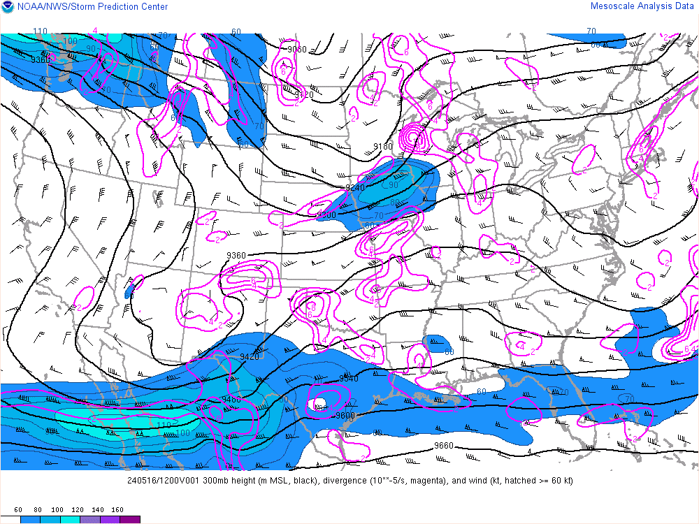
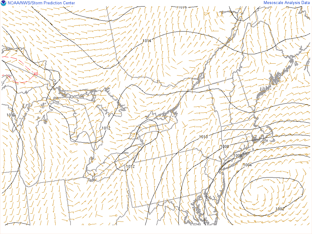
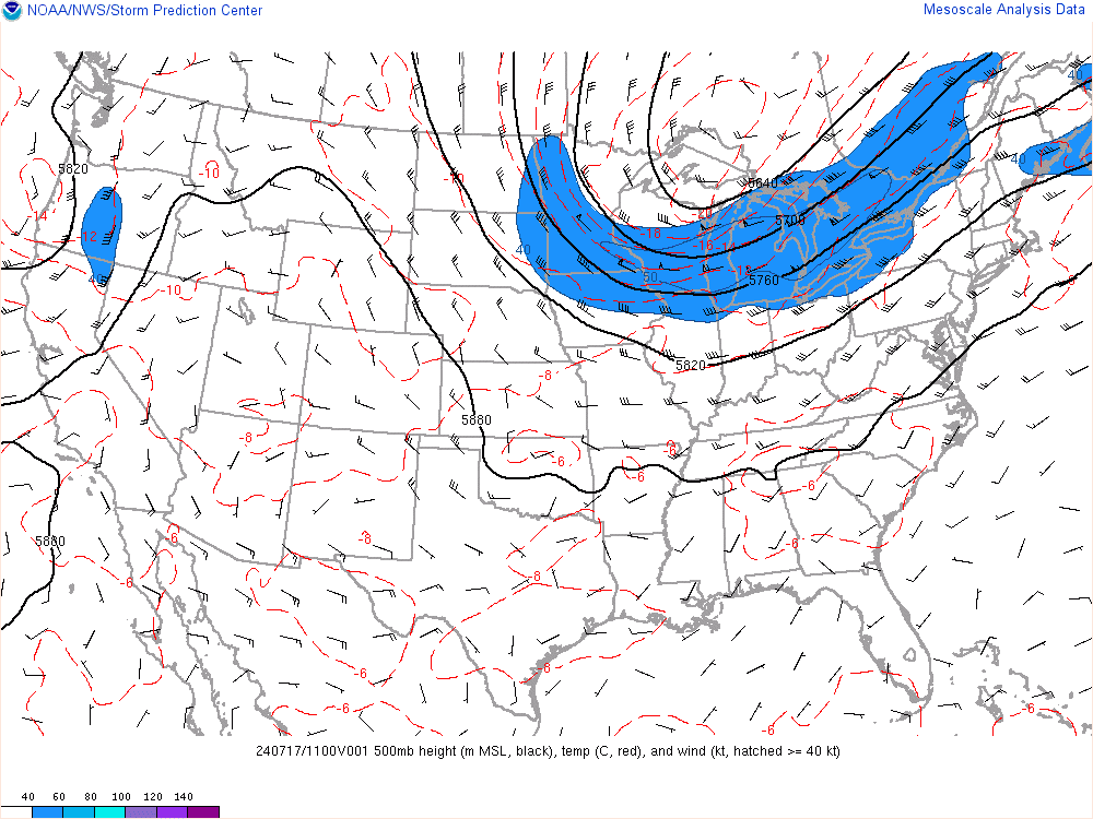
As you can see by the map below the 500mb low has closed off over Kentucky/W Va region and will begin to deepen and head E NE from here. Remember from discussions yesterday as well as some others the best banding will form N&W of this ULL as it passes south of LI. This wont happen until later today. This is the second wave and the main event. Now how far S&E the center of this ULL passes will dictate where the heaviest axis of snow ends up.
[url=https://servimg.com/view/18491850/2794]

_________________
"In weather and in life, there's no winning and losing; there's only winning and learning."
WINTER 2012/2013 TOTALS 43.65"WINTER 2017/2018 TOTALS 62.85" WINTER 2022/2023 TOTALS 4.9"
WINTER 2013/2014 TOTALS 64.85"WINTER 2018/2019 TOTALS 14.25" WINTER 2023/2024 TOTALS 13.1"
WINTER 2014/2015 TOTALS 71.20"WINTER 2019/2020 TOTALS 6.35"
WINTER 2015/2016 TOTALS 35.00"WINTER 2020/2021 TOTALS 37.75"
WINTER 2016/2017 TOTALS 42.25"WINTER 2021/2022 TOTALS 31.65"

sroc4- Admin

- Posts : 8331
Reputation : 301
Join date : 2013-01-07
Location : Wading River, LI
Re: March Madness! Spring Snowstorm Observations
![]() by billg315 Wed Mar 21, 2018 7:23 am
by billg315 Wed Mar 21, 2018 7:23 am
billg315- Advanced Forecaster - Mod
- Posts : 4462
Reputation : 185
Join date : 2015-01-24
Age : 50
Location : Flemington, NJ
Re: March Madness! Spring Snowstorm Observations
![]() by CPcantmeasuresnow Wed Mar 21, 2018 7:32 am
by CPcantmeasuresnow Wed Mar 21, 2018 7:32 am
I'm not saying this is the same setup, it's somewhat different but the logic remains the same. Even the mesoscales can't pckkup who will band, dryslot be subject to subsidence etc with any degree of certainty, 10-20 miles can make great differences.
Enjoy the show I'm in it for the stats today and hopng like everyone else my area over performs.
Please step away from the ledges. When you feel yourself short of breath go to the weather stats thread and peruse the stats of storms and winters past.
May the Frontogenesis Forcing be with you.

CPcantmeasuresnow- Wx Statistician Guru
- Posts : 7274
Reputation : 230
Join date : 2013-01-07
Age : 103
Location : Eastern Orange County, NY
Re: March Madness! Spring Snowstorm Observations
![]() by nutleyblizzard Wed Mar 21, 2018 7:35 am
by nutleyblizzard Wed Mar 21, 2018 7:35 am
Well, I guess I'm not going to work today. I was just out the door when my boss texted me to stay home. Let the storm tracking commence!!!nutleyblizzard wrote:Bingo! With every ensuing model run that comes out, it gives a different depiction of snow totals depending where the heavier snow bands setup. Thats the reason for the panic and joy in this forum. We just have to wait till this afternoon how things will shake down. One things for sure, someone is going to get clobbered. Hopefully it will be most of us. Going to work now.billg315 wrote:As for jackpot zones, GFS actually moves it slightly west over eastern PA/NW NJ. The NAM has it from NYC across LI. Either way I think model snow maps aren’t great at pinpointing jackpots anyway so that we won’t know until the heavy bands set up this afternoon.
nutleyblizzard- Senior Enthusiast
- Posts : 1952
Reputation : 41
Join date : 2014-01-30
Age : 58
Location : Nutley, new jersey
Page 26 of 40 • 1 ... 14 ... 25, 26, 27 ... 33 ... 40 ![]()
|
|
|