
 Search
Long Range Discussion 20(20) (Ha!)
Page 6 of 30 •  1 ... 5, 6, 7 ... 18 ... 30
 ![]()
Re: Long Range Discussion 20(20) (Ha!)
![]() by rb924119 Fri Dec 04, 2020 6:11 am
by rb924119 Fri Dec 04, 2020 6:11 am
amugs wrote:We have a Start Warming event taking place as per the GFS from the EPO heat transport over the Alaska region, longer term colder solution?
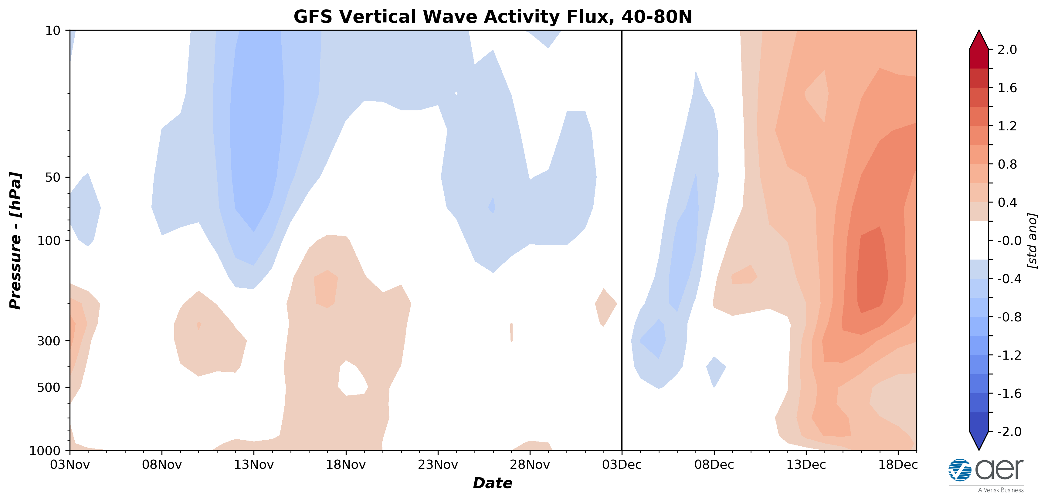
So here’s my opinion on any **potential** SSW event, and this was ripped from another discussion with a fellow poster, as well as from a post elsewhere:
“....if we can really get the MJO to gain serious amplitude and propagate SLOWLY through the Maritime Continent, that’s a precursor to a true SSW event with favorable alignment (for our region) thanks to the thermodynamics involved. But, we’d have to both take it on the proverbial chin and deal with another torch of a December and probably first half of January AND THEN hope that it’s enough to seriously weaken the anomalously strong stratospheric vortex in a background/QBO state that lessens the overall receptivity to such perturbation. But I think that would really be our best shot at seeing any prolonged winter regime in the eastern CONUS, and have for some time, as at least conceptually, the conditions are mildly decent for the tropospheric evolution.”
With regard to what is being shown on the GFS Op at hour 384, this will likely continue to be mainly overdone, at least for the foreseeable future unless we get a very impressive tropical forcing response for an extended period (i.e. the MJO/standing wave reach 2-sigma or greater deviation for several weeks). IF I start seeing that, again, it’s PLAUSIBLE that this occurs given the likely positive interference that I think will occur between the standing wave and MJO pulse, but I’m not sure if the verified amplitude will be enough given the pre-existing strength of the PV. That said, ANY positive interference between the tropical convective modes will help to weaken it some if it’s sustained long enough. The question is: Would it be enough to give us hope for prolonged winter weather? Without a true SSW, I honestly don’t think so.
P.S. Yes, my other write up is still in the works - I’ve been forced chip away at it rather than blast it out all at once.
rb924119- Meteorologist

- Posts : 6928
Join date : 2013-02-06
Re: Long Range Discussion 20(20) (Ha!)
![]() by Wheezer Fri Dec 04, 2020 10:40 am
by Wheezer Fri Dec 04, 2020 10:40 am
Can someone explain what in blue blazes we need to have a sustained -EPO . With the difference of this years IOD(neutral) and now a moderate LA Nina , why can't the tropical forcing give us a sustained -EPO . I know there's no easy answer, but there has to be something that lends for a more likely -EPO
Wheezer- Posts : 30
Join date : 2017-11-08
Re: Long Range Discussion 20(20) (Ha!)
![]() by Frank_Wx Fri Dec 04, 2020 3:23 pm
by Frank_Wx Fri Dec 04, 2020 3:23 pm
_________________
_______________________________________________________________________________________________________
CLICK HERE to view NJ Strong Snowstorm Classifications

Frank_Wx- Godzilla Seeker

- Posts : 21305
Reputation : 328
Join date : 2013-01-05
Age : 32
Location : Jersey City, NJ -

Re: Long Range Discussion 20(20) (Ha!)
![]() by Math23x7 Fri Dec 04, 2020 3:52 pm
by Math23x7 Fri Dec 04, 2020 3:52 pm
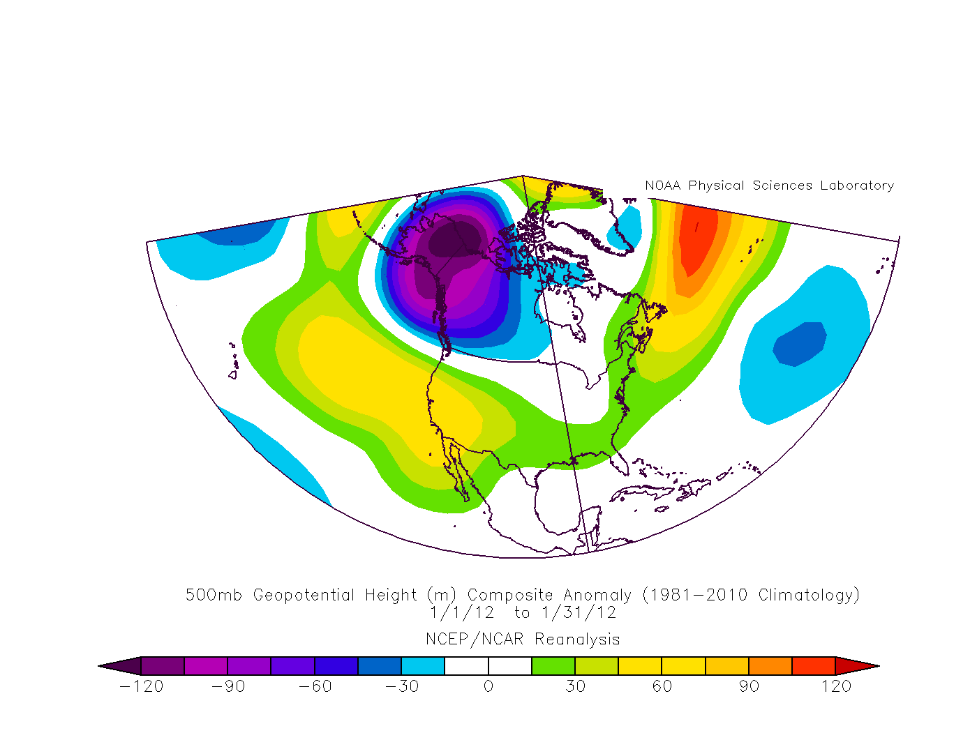
Frank_Wx wrote:I am seeing one pretty big and disturbing trend in the long range. The trop polar vortex, or a piece of it, is trying to move toward Alaska and stay there. A TPV over Alaska = very bad news for seeing colder than normal weather in our area. We'll see if it comes to fruition or not. Here is one analog I saw thrown around today, January 2012.
NOAA seems to be picking up on that as well:

Math23x7- Wx Statistician Guru

- Posts : 2379
Reputation : 68
Join date : 2013-01-08
Re: Long Range Discussion 20(20) (Ha!)
![]() by amugs Sun Dec 06, 2020 9:28 am
by amugs Sun Dec 06, 2020 9:28 am
_________________
Mugs
AKA:King: Snow Weenie
Self Proclaimed
WINTER 2014-15 : 55.12" +.02 for 6 coatings (avg. 35")
WINTER 2015-16 Total - 29.8" (Avg 35")
WINTER 2016-17 : 39.5" so far

amugs- Advanced Forecaster - Mod

- Posts : 15095
Reputation : 213
Join date : 2013-01-07
Age : 54
Location : Hillsdale,NJ
Re: Long Range Discussion 20(20) (Ha!)
![]() by amugs Mon Dec 07, 2020 5:46 pm
by amugs Mon Dec 07, 2020 5:46 pm

AO looks to be Negative = Good Sign

EPO looks to go positive = Mal

PNA is going Negative = Mal x2

End of the run looks to be warming up BUT the N NAO may just keep rolling over the top and pushing the Trough over AK more to the Aleutian's and..... it 13 days away so lot of time. There will be a chance next week for a storm and maybe another 2 after that as the longitutidonal wavelengths shorten as we head into the winter solstice.

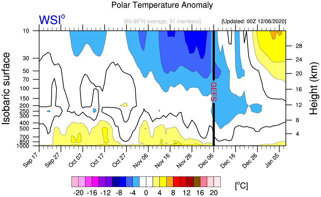
We have a Strat warming that could take effect later Dec and have effects mid January.

Winds are declining rapidly as well

Lastly, we have Jupiter and Saturn to align in December to create 'Christmas Star' for first time in 800 years. For the first time in nearly 800 years, Jupiter and Saturn will align in the winter solstice sky to become what is known as the "Christmas Star". What will this mean for us here on planet Earth?? Who knows but in 1220 it started...the next 4 years this is what occurred that can be researched from that time frame weather wise and tehir were 3 major wars
A cold winter in western Europe / implied parts of Britain. (Easton, in CHMW/Lamb)
A violent northeasterly gale did much damage in London; the exact year/date is uncertain.
Dry. Hot/dry summer in London/South.
A very wet year with much flooding.
A severe winter. (Easton)
Severe Winter (London/South)
_________________
Mugs
AKA:King: Snow Weenie
Self Proclaimed
WINTER 2014-15 : 55.12" +.02 for 6 coatings (avg. 35")
WINTER 2015-16 Total - 29.8" (Avg 35")
WINTER 2016-17 : 39.5" so far
amugs- Advanced Forecaster - Mod
- Posts : 15095
Reputation : 213
Join date : 2013-01-07
Age : 54
Location : Hillsdale,NJ
Re: Long Range Discussion 20(20) (Ha!)
![]() by amugs Mon Dec 07, 2020 5:51 pm
by amugs Mon Dec 07, 2020 5:51 pm
_________________
Mugs
AKA:King: Snow Weenie
Self Proclaimed
WINTER 2014-15 : 55.12" +.02 for 6 coatings (avg. 35")
WINTER 2015-16 Total - 29.8" (Avg 35")
WINTER 2016-17 : 39.5" so far
amugs- Advanced Forecaster - Mod
- Posts : 15095
Reputation : 213
Join date : 2013-01-07
Age : 54
Location : Hillsdale,NJ
Re: Long Range Discussion 20(20) (Ha!)
![]() by Frank_Wx Mon Dec 07, 2020 8:55 pm
by Frank_Wx Mon Dec 07, 2020 8:55 pm
amugs wrote:If this happens we'll be in good shape for a bulk of winter IMO, that is a big IF!!
This is going to be key. A split early in the winter would save us from locking into an ugly La Niña pattern. Let’s see what happens
_________________
_______________________________________________________________________________________________________
CLICK HERE to view NJ Strong Snowstorm Classifications
Frank_Wx- Godzilla Seeker
- Posts : 21305
Reputation : 328
Join date : 2013-01-05
Age : 32
Location : Jersey City, NJ -
Re: Long Range Discussion 20(20) (Ha!)
![]() by amugs Tue Dec 08, 2020 8:34 pm
by amugs Tue Dec 08, 2020 8:34 pm
GEFS


PNA Neutral - up from Negative

May cut but good to see the NAO popping up here

When was the last time we had a coast to coast trough?? Anyone?

That a nice NAO block - open window here for multiple waves??

Xmas miracle?? PNA popping, NAO adn AO with a trough in the S

This has trended more troughy and more blocking the past couple of days. Lets keep an eye on this period. I am going to try my Winter Weenie Darnest to bring us some white gold goods for the holiday!
EPS say hello for the same time frame

_________________
Mugs
AKA:King: Snow Weenie
Self Proclaimed
WINTER 2014-15 : 55.12" +.02 for 6 coatings (avg. 35")
WINTER 2015-16 Total - 29.8" (Avg 35")
WINTER 2016-17 : 39.5" so far
amugs- Advanced Forecaster - Mod
- Posts : 15095
Reputation : 213
Join date : 2013-01-07
Age : 54
Location : Hillsdale,NJ
Re: Long Range Discussion 20(20) (Ha!)
![]() by sroc4 Wed Dec 09, 2020 6:56 am
by sroc4 Wed Dec 09, 2020 6:56 am
amugs wrote:Okay good tele trends the past couple of days saying we have the wonder twins activating for us. Doesn't mean arctic cold but cold enough.
GEFS
PNA Neutral - up from Negative
May cut but good to see the NAO popping up here
When was the last time we had a coast to coast trough?? Anyone?
That a nice NAO block - open window here for multiple waves??
Xmas miracle?? PNA popping, NAO adn AO with a trough in the S
This has trended more troughy and more blocking the past couple of days. Lets keep an eye on this period. I am going to try my Winter Weenie Darnest to bring us some white gold goods for the holiday!
EPS say hello for the same time frame
Just quickly looking I definitely think there can be a couple of chances next week beginning with Monday Tuesday time frame. As we head deeper into Dec and esp into Jan these marginal temp events will get more and more favorable due to climatology on our side. For now monitor 500 for Monday Tuesday.
_________________
"In weather and in life, there's no winning and losing; there's only winning and learning."
WINTER 2012/2013 TOTALS 43.65"WINTER 2017/2018 TOTALS 62.85" WINTER 2022/2023 TOTALS 4.9"
WINTER 2013/2014 TOTALS 64.85"WINTER 2018/2019 TOTALS 14.25" WINTER 2023/2024 TOTALS 13.1"
WINTER 2014/2015 TOTALS 71.20"WINTER 2019/2020 TOTALS 6.35"
WINTER 2015/2016 TOTALS 35.00"WINTER 2020/2021 TOTALS 37.75"
WINTER 2016/2017 TOTALS 42.25"WINTER 2021/2022 TOTALS 31.65"

sroc4- Admin
- Posts : 8354
Reputation : 302
Join date : 2013-01-07
Location : Wading River, LI
Re: Long Range Discussion 20(20) (Ha!)
![]() by amugs Wed Dec 09, 2020 8:37 am
by amugs Wed Dec 09, 2020 8:37 am

As per SROC - we get a shortening of teh wavelengths so things can get tricky for models to pick up on this transition.
_________________
Mugs
AKA:King: Snow Weenie
Self Proclaimed
WINTER 2014-15 : 55.12" +.02 for 6 coatings (avg. 35")
WINTER 2015-16 Total - 29.8" (Avg 35")
WINTER 2016-17 : 39.5" so far
amugs- Advanced Forecaster - Mod
- Posts : 15095
Reputation : 213
Join date : 2013-01-07
Age : 54
Location : Hillsdale,NJ
Re: Long Range Discussion 20(20) (Ha!)
![]() by amugs Wed Dec 09, 2020 10:28 am
by amugs Wed Dec 09, 2020 10:28 am
_________________
Mugs
AKA:King: Snow Weenie
Self Proclaimed
WINTER 2014-15 : 55.12" +.02 for 6 coatings (avg. 35")
WINTER 2015-16 Total - 29.8" (Avg 35")
WINTER 2016-17 : 39.5" so far
amugs- Advanced Forecaster - Mod
- Posts : 15095
Reputation : 213
Join date : 2013-01-07
Age : 54
Location : Hillsdale,NJ
Re: Long Range Discussion 20(20) (Ha!)
![]() by Frank_Wx Wed Dec 09, 2020 10:42 am
by Frank_Wx Wed Dec 09, 2020 10:42 am

The GEFS keep the -NAO in place through Christmas

If the GEFS are also correct in popping the ridge out west, this could get verrrrry interesting.
_________________
_______________________________________________________________________________________________________
CLICK HERE to view NJ Strong Snowstorm Classifications
Frank_Wx- Godzilla Seeker
- Posts : 21305
Reputation : 328
Join date : 2013-01-05
Age : 32
Location : Jersey City, NJ -
Re: Long Range Discussion 20(20) (Ha!)
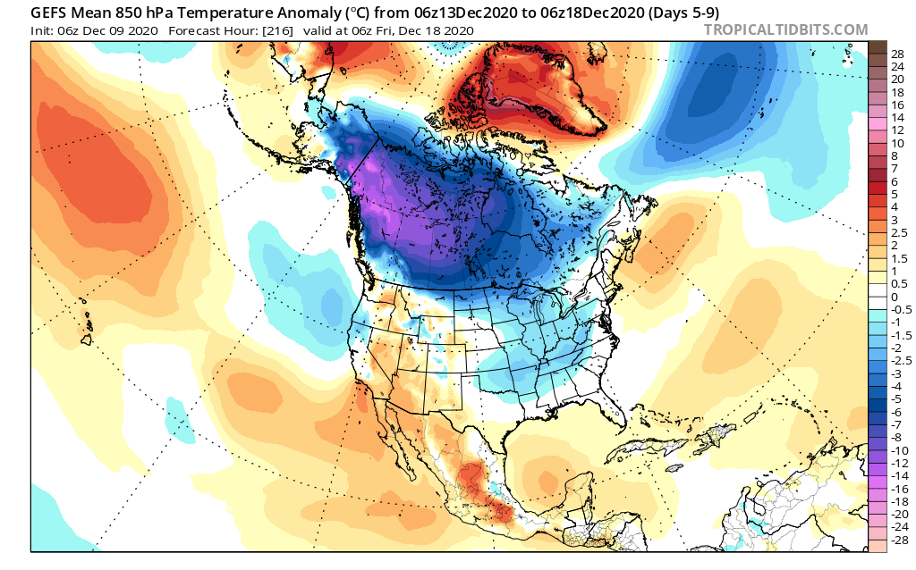
![]() by amugs Wed Dec 09, 2020 3:03 pm
by amugs Wed Dec 09, 2020 3:03 pm
https://twitter.com/webberweather/status/1336757629612421124?s=20
_________________
Mugs
AKA:King: Snow Weenie
Self Proclaimed
WINTER 2014-15 : 55.12" +.02 for 6 coatings (avg. 35")
WINTER 2015-16 Total - 29.8" (Avg 35")
WINTER 2016-17 : 39.5" so far
amugs- Advanced Forecaster - Mod
- Posts : 15095
Reputation : 213
Join date : 2013-01-07
Age : 54
Location : Hillsdale,NJ
Re: Long Range Discussion 20(20) (Ha!)
![]() by nutleyblizzard Wed Dec 09, 2020 3:03 pm
by nutleyblizzard Wed Dec 09, 2020 3:03 pm

nutleyblizzard- Senior Enthusiast

- Posts : 1954
Reputation : 41
Join date : 2014-01-30
Age : 58
Location : Nutley, new jersey
Re: Long Range Discussion 20(20) (Ha!)
![]() by Frank_Wx Wed Dec 09, 2020 3:42 pm
by Frank_Wx Wed Dec 09, 2020 3:42 pm
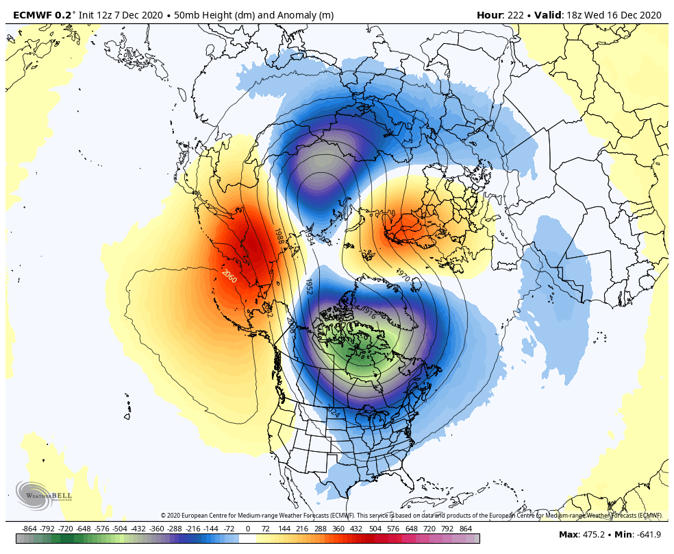
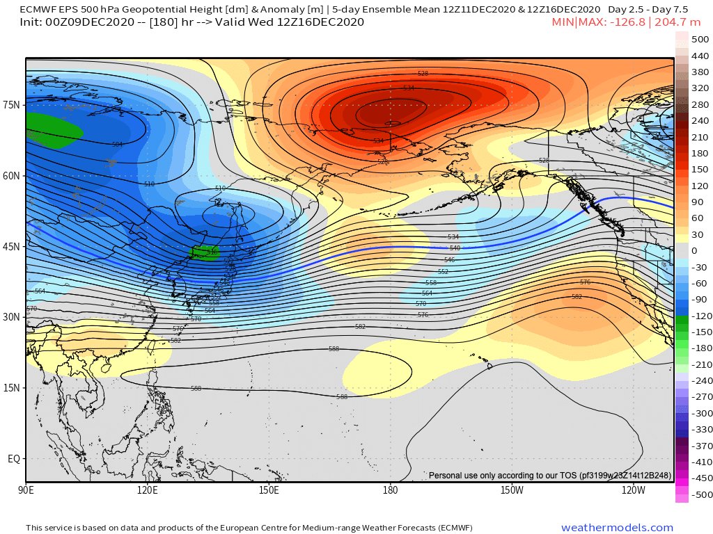
amugs wrote:EURO splits the PV wowza!!!
https://twitter.com/webberweather/status/1336757629612421124?s=20
WOW!!!!!!!!!!!

_________________
_______________________________________________________________________________________________________
CLICK HERE to view NJ Strong Snowstorm Classifications
Frank_Wx- Godzilla Seeker
- Posts : 21305
Reputation : 328
Join date : 2013-01-05
Age : 32
Location : Jersey City, NJ -
Re: Long Range Discussion 20(20) (Ha!)
![]() by sroc4 Wed Dec 09, 2020 6:26 pm
by sroc4 Wed Dec 09, 2020 6:26 pm
Frank_Wx wrote:amugs wrote:EURO splits the PV wowza!!!
https://twitter.com/webberweather/status/1336757629612421124?s=20
WOW!!!!!!!!!!!
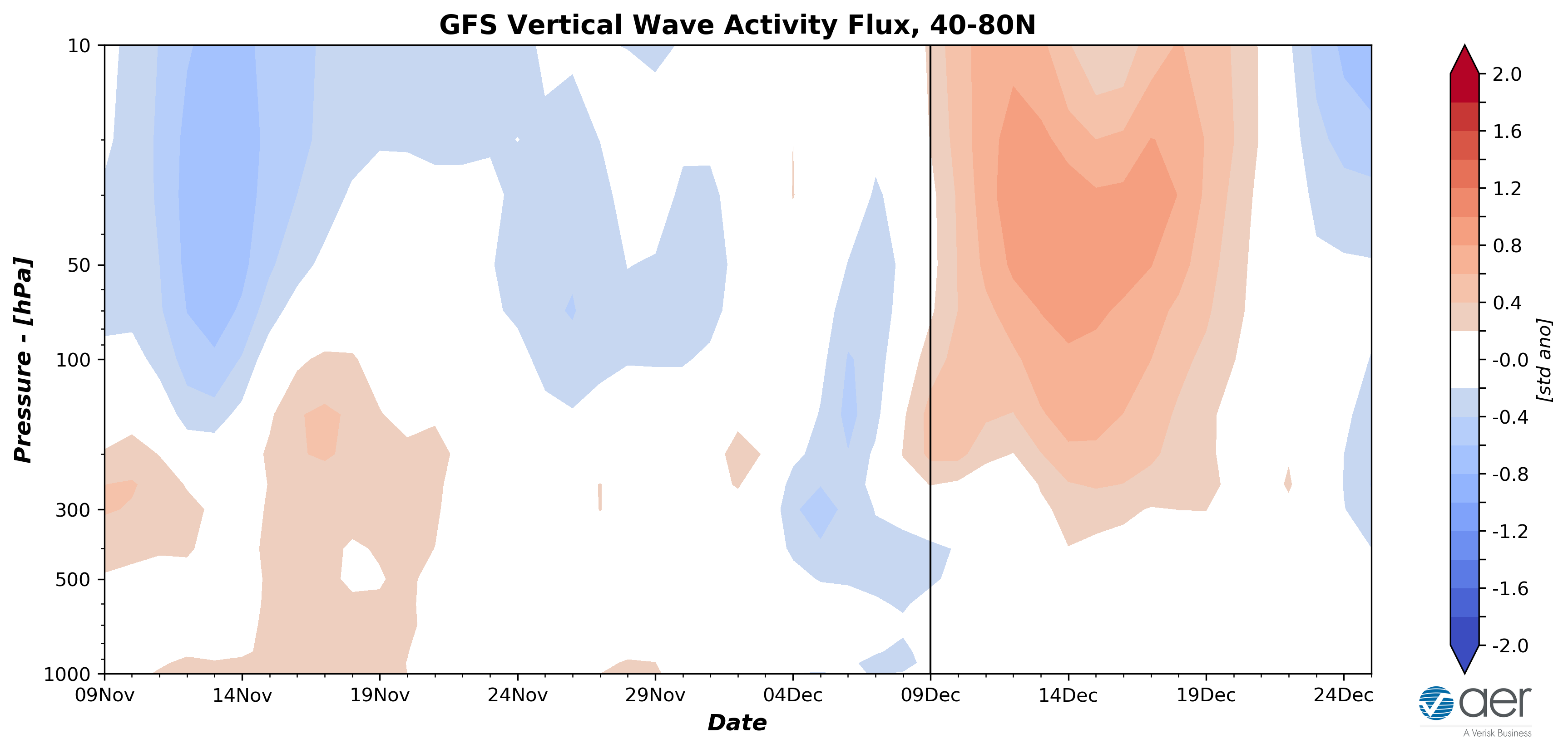
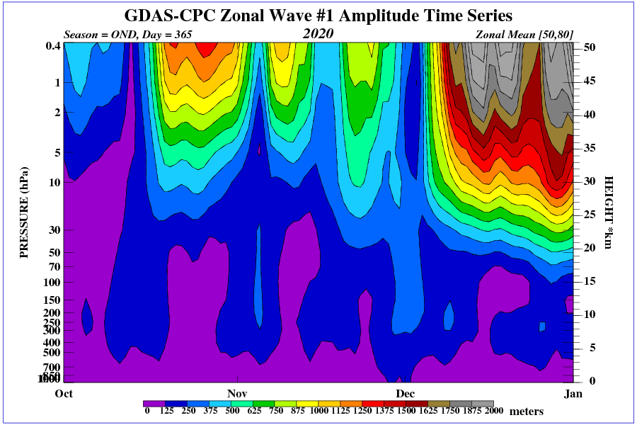
If the strat ends up spliting like is being depicted on all of the 12z runs today then its def game on. That said the long range forcast has a way of tempering itself so I am tempering expectations at the moment. I worry this is just another head fake.

That said there has been a wave 1 attack underway. The true results of which are likely not completely modeled correctly just yet. Mugsy has posted a diff map showing the warming as well.
_________________
"In weather and in life, there's no winning and losing; there's only winning and learning."
WINTER 2012/2013 TOTALS 43.65"WINTER 2017/2018 TOTALS 62.85" WINTER 2022/2023 TOTALS 4.9"
WINTER 2013/2014 TOTALS 64.85"WINTER 2018/2019 TOTALS 14.25" WINTER 2023/2024 TOTALS 13.1"
WINTER 2014/2015 TOTALS 71.20"WINTER 2019/2020 TOTALS 6.35"
WINTER 2015/2016 TOTALS 35.00"WINTER 2020/2021 TOTALS 37.75"
WINTER 2016/2017 TOTALS 42.25"WINTER 2021/2022 TOTALS 31.65"
sroc4- Admin
- Posts : 8354
Reputation : 302
Join date : 2013-01-07
Location : Wading River, LI
Re: Long Range Discussion 20(20) (Ha!)
![]() by amugs Wed Dec 09, 2020 7:27 pm
by amugs Wed Dec 09, 2020 7:27 pm
Eric Webb has posted
Unlike many -NAO/+EPOs, the one that's showing up in the longer term might have easier access to Arctic air if the -NAO hangs around past mid-December.
A -WPO this week will seed Alaska & NW Canada w/ cold air from NE Siberia, the coldest place in the N hem during boreal winter
These maps are very encouraging
WPO that would pump and drive teh Siberian express into CANADA and then into the CONUS. Freeze Canada and I'll take my chances!
Peeps this is extremely encouraging and you can see the freezer in AK and into Western Canada - that flow is good sign.
EURO
AO Diving Negative

NAO as well

PNA hanging around Neutral

GEFS says I', lock in step with you EURO
AO

NAO

PNA - N to Positive = even better

EURO - XMAS EVE - A good look overall look with the AO and NAO block and PNA rising

GEFS says BOOM BOOM - LOL I know 15 days out but it is a good look

_________________
Mugs
AKA:King: Snow Weenie
Self Proclaimed
WINTER 2014-15 : 55.12" +.02 for 6 coatings (avg. 35")
WINTER 2015-16 Total - 29.8" (Avg 35")
WINTER 2016-17 : 39.5" so far
amugs- Advanced Forecaster - Mod
- Posts : 15095
Reputation : 213
Join date : 2013-01-07
Age : 54
Location : Hillsdale,NJ
Re: Long Range Discussion 20(20) (Ha!)
![]() by Radz Thu Dec 10, 2020 3:07 am
by Radz Thu Dec 10, 2020 3:07 am

Radz- Pro Enthusiast

- Posts : 1028
Reputation : 17
Join date : 2013-01-12
Location : Cortlandt Manor NY
Re: Long Range Discussion 20(20) (Ha!)
![]() by aiannone Thu Dec 10, 2020 11:24 am
by aiannone Thu Dec 10, 2020 11:24 am

_________________
-Alex Iannone-

aiannone- Senior Enthusiast - Mod
- Posts : 4815
Reputation : 92
Join date : 2013-01-07
Location : Saint James, LI (Northwest Suffolk Co.)
Re: Long Range Discussion 20(20) (Ha!)
![]() by phil155 Thu Dec 10, 2020 11:42 am
by phil155 Thu Dec 10, 2020 11:42 am
phil155- Pro Enthusiast
- Posts : 483
Reputation : 4
Join date : 2019-12-16
Re: Long Range Discussion 20(20) (Ha!)
![]() by SoulSingMG Thu Dec 10, 2020 1:06 pm
by SoulSingMG Thu Dec 10, 2020 1:06 pm

Pattern next week is RIPE.


SoulSingMG- Senior Enthusiast
- Posts : 2853
Reputation : 74
Join date : 2013-12-11
Location : Long Island City, NY
SENJsnowman likes this post
Re: Long Range Discussion 20(20) (Ha!)
![]() by Irish Thu Dec 10, 2020 1:33 pm
by Irish Thu Dec 10, 2020 1:33 pm
SoulSingMG wrote:Although week-out snowfall maps usually belong in banter, I thought we could all use some 2020 colorful hope since it’s been a real stinker of a year and 84 years since we’ve seen a good snowstorm in NYC metro.
Pattern next week is RIPE.
Hell, I'll take half of what my area is colored for on that map!

Irish- Pro Enthusiast
- Posts : 788
Reputation : 19
Join date : 2019-01-16
Age : 45
Location : Old Bridge, NJ

nutleyblizzard- Senior Enthusiast
- Posts : 1954
Reputation : 41
Join date : 2014-01-30
Age : 58
Location : Nutley, new jersey
Re: Long Range Discussion 20(20) (Ha!)
![]() by billg315 Thu Dec 10, 2020 2:41 pm
by billg315 Thu Dec 10, 2020 2:41 pm

billg315- Advanced Forecaster - Mod
- Posts : 4483
Reputation : 185
Join date : 2015-01-24
Age : 50
Location : Flemington, NJ
Re: Long Range Discussion 20(20) (Ha!)
![]() by skinsfan1177 Thu Dec 10, 2020 2:55 pm
by skinsfan1177 Thu Dec 10, 2020 2:55 pm

skinsfan1177- Senior Enthusiast
- Posts : 4485
Reputation : 35
Join date : 2013-01-07
Age : 46
Location : Point Pleasant Boro
Re: Long Range Discussion 20(20) (Ha!)
![]() by sroc4 Thu Dec 10, 2020 2:57 pm
by sroc4 Thu Dec 10, 2020 2:57 pm
_________________
"In weather and in life, there's no winning and losing; there's only winning and learning."
WINTER 2012/2013 TOTALS 43.65"WINTER 2017/2018 TOTALS 62.85" WINTER 2022/2023 TOTALS 4.9"
WINTER 2013/2014 TOTALS 64.85"WINTER 2018/2019 TOTALS 14.25" WINTER 2023/2024 TOTALS 13.1"
WINTER 2014/2015 TOTALS 71.20"WINTER 2019/2020 TOTALS 6.35"
WINTER 2015/2016 TOTALS 35.00"WINTER 2020/2021 TOTALS 37.75"
WINTER 2016/2017 TOTALS 42.25"WINTER 2021/2022 TOTALS 31.65"
sroc4- Admin
- Posts : 8354
Reputation : 302
Join date : 2013-01-07
Location : Wading River, LI
Page 6 of 30 • 1 ... 5, 6, 7 ... 18 ... 30 ![]()
|
|
|