
 Search
Long Range Discussion 20(20) (Ha!)
Page 7 of 30 •  1 ... 6, 7, 8 ... 18 ... 30
 ![]()
Re: Long Range Discussion 20(20) (Ha!)
![]() by skinsfan1177 Thu Dec 10, 2020 2:55 pm
by skinsfan1177 Thu Dec 10, 2020 2:55 pm
skinsfan1177- Senior Enthusiast

- Posts : 4485
Join date : 2013-01-07
sroc4- Admin

- Posts : 8331
Join date : 2013-01-07
Re: Long Range Discussion 20(20) (Ha!)
![]() by Irish Thu Dec 10, 2020 2:59 pm
by Irish Thu Dec 10, 2020 2:59 pm
nutleyblizzard wrote:
Euro on board

That is a severe cut off line per the usual. I hope this baby shifts SE.

Irish- Pro Enthusiast

- Posts : 788
Reputation : 19
Join date : 2019-01-16
Age : 45
Location : Old Bridge, NJ
Re: Long Range Discussion 20(20) (Ha!)
![]() by weatherwatchermom Thu Dec 10, 2020 5:46 pm
by weatherwatchermom Thu Dec 10, 2020 5:46 pm
Irish wrote:nutleyblizzard wrote:
Euro on board
That is a severe cut off line per the usual. I hope this baby shifts SE.
me too

weatherwatchermom- Senior Enthusiast
- Posts : 3733
Reputation : 77
Join date : 2014-11-25
Age : 60
Location : Hazlet Township, NJ
Re: Long Range Discussion 20(20) (Ha!)
![]() by bobjohnsonforthehall Thu Dec 10, 2020 7:34 pm
by bobjohnsonforthehall Thu Dec 10, 2020 7:34 pm
Yes please

bobjohnsonforthehall- Posts : 311
Reputation : 19
Join date : 2016-10-02
Location : Flemington NJ
Re: Long Range Discussion 20(20) (Ha!)
![]() by Frank_Wx Thu Dec 10, 2020 8:51 pm
by Frank_Wx Thu Dec 10, 2020 8:51 pm
_________________
_______________________________________________________________________________________________________
CLICK HERE to view NJ Strong Snowstorm Classifications

Frank_Wx- Godzilla Seeker
- Posts : 21305
Reputation : 328
Join date : 2013-01-05
Age : 31
Location : Jersey City, NJ -

Re: Long Range Discussion 20(20) (Ha!)
![]() by rb924119 Thu Dec 10, 2020 9:47 pm
by rb924119 Thu Dec 10, 2020 9:47 pm
I’ve gotta be honest, and I’m sure this will incite riots, but unbiased opinion is that I am not impressed with this setup, and am banking on it either sliding to our south on account of a missed phase because of the secondary energy rocketing in from the Pacific, stringing out, but toppling what little transient PNA spike there will be (somebody mentioned this before, can’t recall whom, though), or, earlier phasing and it comes too far west with too much warm air to work with. Not sure which I favor yet, but I’ll have to do some more digging and revert. Either way, I strongly believe that this ends up to not be our storm.
rb924119- Meteorologist

- Posts : 6889
Reputation : 194
Join date : 2013-02-06
Age : 32
Location : Greentown, Pa
Re: Long Range Discussion 20(20) (Ha!)
![]() by rb924119 Thu Dec 10, 2020 9:51 pm
by rb924119 Thu Dec 10, 2020 9:51 pm
rb924119- Meteorologist
- Posts : 6889
Reputation : 194
Join date : 2013-02-06
Age : 32
Location : Greentown, Pa
Re: Long Range Discussion 20(20) (Ha!)
![]() by amugs Thu Dec 10, 2020 10:10 pm
by amugs Thu Dec 10, 2020 10:10 pm
The westerly QBO is beginning to descend down to the top of the Troposphere. We'll see if it gets there but it could mean reduced or weaker MJO activity this Winter.
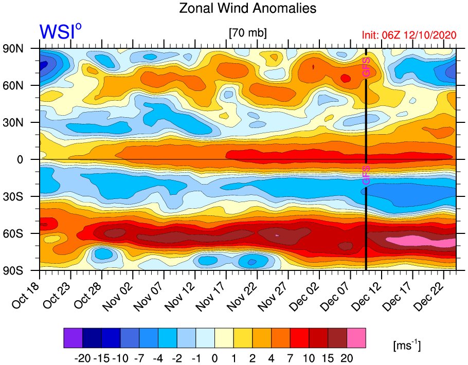
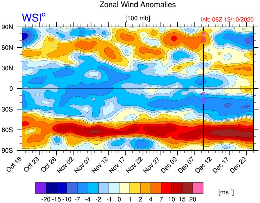
For the questions pertaining to what does this mean for Winter: Weaker MJO activity suggests that some other mechanism could drive the pattern. What that mechanism is? TBD
Between 10MB and 30MB we have an eastern descending wind and trend.
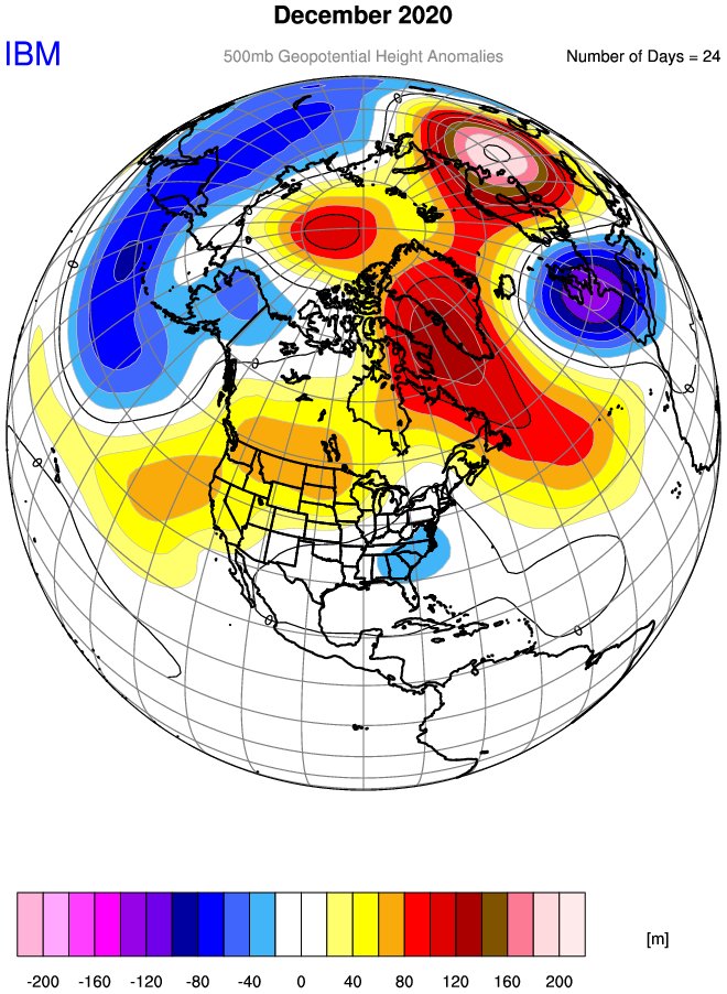
500MB map - where does one sign??
_________________
Mugs
AKA:King: Snow Weenie
Self Proclaimed
WINTER 2014-15 : 55.12" +.02 for 6 coatings (avg. 35")
WINTER 2015-16 Total - 29.8" (Avg 35")
WINTER 2016-17 : 39.5" so far

amugs- Advanced Forecaster - Mod

- Posts : 15093
Reputation : 213
Join date : 2013-01-07
Age : 54
Location : Hillsdale,NJ
Re: Long Range Discussion 20(20) (Ha!)
![]() by jmanley32 Thu Dec 10, 2020 11:50 pm
by jmanley32 Thu Dec 10, 2020 11:50 pm
Ohhh mama, I been MIA a few days and looks what pops up, maybe I am the curse, maybe I should stay away more often lol. Tempering any expectations but 10-14 inchjes IMBY verbatim there would be almost 4x what I got last year in one shot lolweatherwatchermom wrote:Irish wrote:nutleyblizzard wrote:
Euro on board
That is a severe cut off line per the usual. I hope this baby shifts SE.
me too

jmanley32- Senior Enthusiast
- Posts : 20512
Reputation : 108
Join date : 2013-12-12
Age : 42
Location : Yonkers, NY
Re: Long Range Discussion 20(20) (Ha!)
![]() by sroc4 Fri Dec 11, 2020 7:45 am
by sroc4 Fri Dec 11, 2020 7:45 am
rb924119 wrote:
I’ve gotta be honest, and I’m sure this will incite riots, but unbiased opinion is that I am not impressed with this setup, and am banking on it either sliding to our south on account of a missed phase because of the secondary energy rocketing in from the Pacific, stringing out, but toppling what little transient PNA spike there will be (somebody mentioned this before, can’t recall whom, though), or, earlier phasing and it comes too far west with too much warm air to work with. Not sure which I favor yet, but I’ll have to do some more digging and revert. Either way, I strongly believe that this ends up to not be our storm.
Morning Ray. I have to respectfully disagree with your rough analysis here. I dont think we have to worry about a phase at all with this system for mid week. It looks purely southern stream to me. A southern stream system that will be running into a fresh polar air mass. As is currently being modeled a mid 1030's HP will be parked to the north in the wake of the first system that passes just south of the region late Monday, or perhaps scrapes southern portions of this boards coverage area. Def a diff set up than the one we just had.
The system that we just had had zero cold air to work with. HP to the N with that system was ragged at best in the 10 teens maybe. The freezing line at the surface was way up on, or even just N or, the Canadian boarder as indicated by the Orange line, 850's and 925mb levels were well N&W of the region as well, and the southern energy was much stronger as a cutoff low as it approached flooding the area with very warm temps from surface to mid levels ahead of the apprioaching surface Low. It did phase with N energy but the cold air was too far away and our starting point was way too warm from surface to mid levels to overcome an actually favorable surface low, 850 and 500mb closed low track to bring temps down fast enough.
Not the case in this set up. As you can see the air mass on Tuesday, compliments of the early week system has surface temps from single digits to teens and 20's knocking on the door(black circle)with even most of the coastal plain starting in the mid to upper 30's. More than cold enough, esp with the HP where it is to draw from a cold enough source region. Meanwhile Tuesday ahead of the system the 925-850mb temps are well below freezing as the system approaches again compliments of our fresh injection of a polar air mass. Not that Im looking at these details with any merit just yet but even dew points look great thus far in modeling out ahead of the system, not the case with the last one.

In addition the first system seesm to create a kind of pseudo 50/50 low. Combined with the PNA region out west its just enough to force the track no further west than a coastal hugger worst case scenario IMHO. I can def see a swing and miss to the SE however if the cold air pushes to hard.

Reagrding the PNA ridge GFS trend forecast(euro is modeled very similar in its timing and strength as well currently) has the 500mb forecast trending stronger In the NW CONUS right as our surface LP is coming off the EC. If true the timing of the ridging is such that combined with the HP parked to the N, a pseudo 50/50 LP and the ridge going up instead of on its way down you get a trajectory NE and a track to the SE of LI somehwhere towards the BM. NW of or SE of yet to be determined. However if the timing of the ridge out west isnt modeled correctly then the track of the LP may flatten out and hence the more ENE track and miss to our SE.

Obv still a LOOOONNGGG way to go with this one, but getting the HP set up to the N is step one to the equation which is looking more and more likely. Flooding the area with warm is is becoming less and less likely. Dont get me wrong the coastal plain may still rain or mix if LP track is tucked in, but overall this set up is leaps and bounds better than the last.
WE TRACK!!!!

_________________
"In weather and in life, there's no winning and losing; there's only winning and learning."
WINTER 2012/2013 TOTALS 43.65"WINTER 2017/2018 TOTALS 62.85" WINTER 2022/2023 TOTALS 4.9"
WINTER 2013/2014 TOTALS 64.85"WINTER 2018/2019 TOTALS 14.25" WINTER 2023/2024 TOTALS 13.1"
WINTER 2014/2015 TOTALS 71.20"WINTER 2019/2020 TOTALS 6.35"
WINTER 2015/2016 TOTALS 35.00"WINTER 2020/2021 TOTALS 37.75"
WINTER 2016/2017 TOTALS 42.25"WINTER 2021/2022 TOTALS 31.65"

sroc4- Admin
- Posts : 8331
Reputation : 301
Join date : 2013-01-07
Location : Wading River, LI
Re: Long Range Discussion 20(20) (Ha!)
![]() by amugs Fri Dec 11, 2020 8:07 am
by amugs Fri Dec 11, 2020 8:07 am
NAEF's is the new tool

Here is the description
North American Ensemble Forecast System (NAEFS)
The North American Ensemble Forecast System (NAEFS) is a joint project involving the Meteorological Service of Canada (MSC), the United States National Weather Service (NWS) and the National Meteorological Service of Mexico (NMSM). NAEFS was officially launched in November 2004 in presence of representatives of the three countries.
NAEFS combines state of the art ensemble forecasts, developed at the MSC and the NWS. When combined, the grand ensemble can provide weather forecast guidance for the 1-14 day period that is of higher quality than the currently available operational guidance based on either set of ensembles alone. It allows the generation of a set of forecast products that are seamless across the national boundaries between Canada, the United States and Mexico. The research/development and operational costs of the NAEFS system are shared by the three organizations (MSC, NWS, and NMSM), which make it more cost effective and result in higher quality and more extensive weather forecast products.
_________________
Mugs
AKA:King: Snow Weenie
Self Proclaimed
WINTER 2014-15 : 55.12" +.02 for 6 coatings (avg. 35")
WINTER 2015-16 Total - 29.8" (Avg 35")
WINTER 2016-17 : 39.5" so far
amugs- Advanced Forecaster - Mod
- Posts : 15093
Reputation : 213
Join date : 2013-01-07
Age : 54
Location : Hillsdale,NJ
Re: Long Range Discussion 20(20) (Ha!)
![]() by billg315 Fri Dec 11, 2020 8:33 am
by billg315 Fri Dec 11, 2020 8:33 am

billg315- Advanced Forecaster - Mod
- Posts : 4462
Reputation : 185
Join date : 2015-01-24
Age : 50
Location : Flemington, NJ
Re: Long Range Discussion 20(20) (Ha!)
![]() by Irish Fri Dec 11, 2020 8:55 am
by Irish Fri Dec 11, 2020 8:55 am
Irish- Pro Enthusiast
- Posts : 788
Reputation : 19
Join date : 2019-01-16
Age : 45
Location : Old Bridge, NJ
Re: Long Range Discussion 20(20) (Ha!)
![]() by aiannone Fri Dec 11, 2020 8:59 am
by aiannone Fri Dec 11, 2020 8:59 am

Why? Snow potential line comes right down to the CT coast and cuts through NYC. A track shift of 25-35 miles this far out is def still in play which shifts that line significantly. I personally think at this lead time its reasonable.
_________________
-Alex Iannone-

aiannone- Senior Enthusiast - Mod
- Posts : 4813
Reputation : 92
Join date : 2013-01-07
Location : Saint James, LI (Northwest Suffolk Co.)
Re: Long Range Discussion 20(20) (Ha!)
![]() by rb924119 Fri Dec 11, 2020 9:18 am
by rb924119 Fri Dec 11, 2020 9:18 am
sroc4 wrote:rb924119 wrote:
I’ve gotta be honest, and I’m sure this will incite riots, but unbiased opinion is that I am not impressed with this setup, and am banking on it either sliding to our south on account of a missed phase because of the secondary energy rocketing in from the Pacific, stringing out, but toppling what little transient PNA spike there will be (somebody mentioned this before, can’t recall whom, though), or, earlier phasing and it comes too far west with too much warm air to work with. Not sure which I favor yet, but I’ll have to do some more digging and revert. Either way, I strongly believe that this ends up to not be our storm.
Morning Ray. I have to respectfully disagree with your rough analysis here. I dont think we have to worry about a phase at all with this system for mid week. It looks purely southern stream to me. A southern stream system that will be running into a fresh polar air mass. As is currently being modeled a mid 1030's HP will be parked to the north in the wake of the first system that passes just south of the region late Monday, or perhaps scrapes southern portions of this boards coverage area. Def a diff set up than the one we just had.
The system that we just had had zero cold air to work with. HP to the N with that system was ragged at best in the 10 teens maybe. The freezing line at the surface was way up on, or even just N or, the Canadian boarder as indicated by the Orange line, 850's and 925mb levels were well N&W of the region as well, and the southern energy was much stronger as a cutoff low as it approached flooding the area with very warm temps from surface to mid levels ahead of the apprioaching surface Low. It did phase with N energy but the cold air was too far away and our starting point was way too warm from surface to mid levels to overcome an actually favorable surface low, 850 and 500mb closed low track to bring temps down fast enough.
Not the case in this set up. As you can see the air mass on Tuesday, compliments of the early week system has surface temps from single digits to teens and 20's knocking on the door(black circle)with even most of the coastal plain starting in the mid to upper 30's. More than cold enough, esp with the HP where it is to draw from a cold enough source region. Meanwhile Tuesday ahead of the system the 925-850mb temps are well below freezing as the system approaches again compliments of our fresh injection of a polar air mass. Not that Im looking at these details with any merit just yet but even dew points look great thus far in modeling out ahead of the system, not the case with the last one.
In addition the first system seesm to create a kind of pseudo 50/50 low. Combined with the PNA region out west its just enough to force the track no further west than a coastal hugger worst case scenario IMHO. I can def see a swing and miss to the SE however if the cold air pushes to hard.
Reagrding the PNA ridge GFS trend forecast(euro is modeled very similar in its timing and strength as well currently) has the 500mb forecast trending stronger In the NW CONUS right as our surface LP is coming off the EC. If true the timing of the ridging is such that combined with the HP parked to the N, a pseudo 50/50 LP and the ridge going up instead of on its way down you get a trajectory NE and a track to the SE of LI somehwhere towards the BM. NW of or SE of yet to be determined. However if the timing of the ridge out west isnt modeled correctly then the track of the LP may flatten out and hence the more ENE track and miss to our SE.
Obv still a LOOOONNGGG way to go with this one, but getting the HP set up to the N is step one to the equation which is looking more and more likely. Flooding the area with warm is is becoming less and less likely. Dont get me wrong the coastal plain may still rain or mix if LP track is tucked in, but overall this set up is leaps and bounds better than the last.
WE TRACK!!!!
Hey Scott!
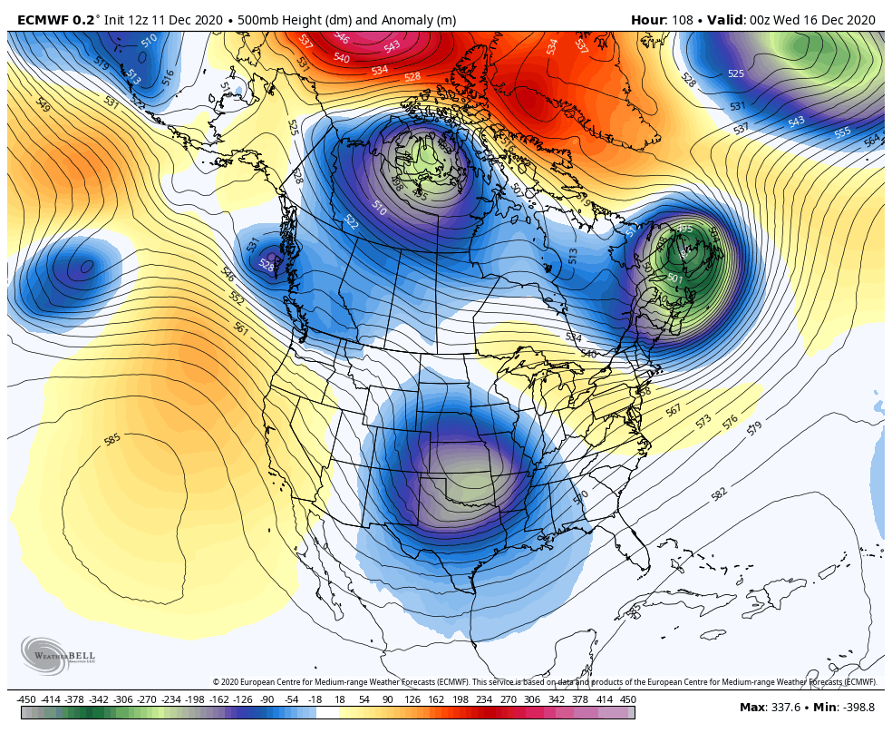
I posted this last night elsewhere in response to another poster questioning why I am not enthused with this setup, and it basically discusses my overarching ideas. Two additional things to counter you here, though: Without the presence of a 70/70 ridge, this works to establish a waveguide that is out of synch for a favorably located trough in the east, which is supported by a mean ridge axis that is OFF the west coast. Ideally, we want to see a well-developed poleward ridge axis over Boise, Idaho. Now, we will have a pseudo ridge, but this is already in the process of deamplifying and becoming positively tilted in response to a surge of momentum and energy streaming in from the Pacific. As this flattens, heights should begin to respond accordingly downstream by rising, in coordination with the below discussion.
I hope the below demonstrates my points well, and I agree that the setup is better, but just honestly don’t think it’s good enough and will end up to be too warm/west for us to really cash in on any substantial totals. I think those will be saved for folks north of 80-84 and west of 81. Regardless, it’s still worth tracking :p

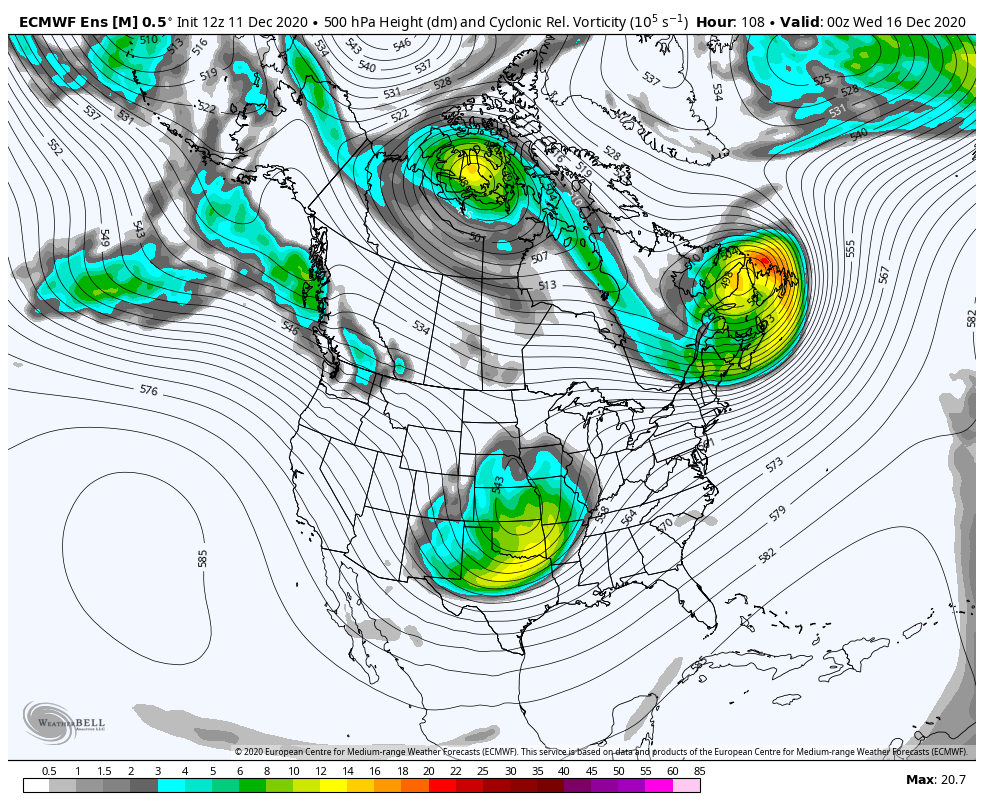
“In this image, I have a few different things quickly and approximately annotated just to try to demonstrate my broader points: our storm of interest is the red "L", our progged evolving surface high pressure (based on basic dynamics of H5, not surface maps) denoted by the two blue "H" enclosed by the blue circle, the outline of what is being referenced as a 50/50 low (which it's actually further northwest than we would like) as well as a second phasing trough, which is Monday's energy, a weakness in the North Atlantic ridging/void in the northern mid-latitude flow in purple, and an idealized surface high pressure in yellow (I'll get to the red arrow shortly). Just looking at these annotations and disregarding the rest of the hemisphere for a moment, you can see that our surface high pressure that initially starts to our northeast becomes contaminated with maritime polar air, thanks to Monday's energy allowing a secondary area of high pressure to slip off the East Coast ahead of the storm of interest. When you consider isallobaric and density components, this will begin imparting an effectual easterly "component" to the low-level and thermal flow, thereby moderating any true arctic component from the northern stream high. Secondly, because of the weakness that is created in response to the phasing of the displaced 50/50 low and Monday's energy beneath blocking that is a bit too far poleward, the phasing energies are forced to slip eastward beneath the block. As they do, they take our surface highs with them, and therefore, the proximity to our lone truly arctic low-level dome decreases as it shifts northeastward behind the departing phasing troughs. Then, as return flow increases in their wake, ridging begins to build behind them (red arrow).
Now, when you consider the rest of the hemispheric and tropical factors, such as the lack of a 70/70 ridge, a truly negative EPO/WPO(for this quick and dirty rebuttal I will consider them as neutral), a truly positive, and well oriented PNA (again, considering this as neutral), and unfavorable tropical forcings combined with anomalously warm Atlantic and Caribbean waters, to me we should see this overall pattern retract toward the pole a bit, thereby allowing everything to shift north (favorable confluence/low-level cold dome, 50/50 low, Atlantic ridge). As a result, then, it would stand to reason that a less favorable storm track and/or airmass becomes more likely than it appears right now in the modeling.
Again, I want to stress that these are quickly put together, general thoughts based on what I've been able to follow and the map in question, and my preliminary post highlighted my underlying uncertainties regarding the eventual outcome. But, this is how I am broadly looking at this.”
rb924119- Meteorologist
- Posts : 6889
Reputation : 194
Join date : 2013-02-06
Age : 32
Location : Greentown, Pa
Re: Long Range Discussion 20(20) (Ha!)
![]() by sroc4 Fri Dec 11, 2020 11:34 am
by sroc4 Fri Dec 11, 2020 11:34 am
rb924119 wrote:sroc4 wrote:rb924119 wrote:
I’ve gotta be honest, and I’m sure this will incite riots, but unbiased opinion is that I am not impressed with this setup, and am banking on it either sliding to our south on account of a missed phase because of the secondary energy rocketing in from the Pacific, stringing out, but toppling what little transient PNA spike there will be (somebody mentioned this before, can’t recall whom, though), or, earlier phasing and it comes too far west with too much warm air to work with. Not sure which I favor yet, but I’ll have to do some more digging and revert. Either way, I strongly believe that this ends up to not be our storm.
Morning Ray. I have to respectfully disagree with your rough analysis here. I dont think we have to worry about a phase at all with this system for mid week. It looks purely southern stream to me. A southern stream system that will be running into a fresh polar air mass. As is currently being modeled a mid 1030's HP will be parked to the north in the wake of the first system that passes just south of the region late Monday, or perhaps scrapes southern portions of this boards coverage area. Def a diff set up than the one we just had.
The system that we just had had zero cold air to work with. HP to the N with that system was ragged at best in the 10 teens maybe. The freezing line at the surface was way up on, or even just N or, the Canadian boarder as indicated by the Orange line, 850's and 925mb levels were well N&W of the region as well, and the southern energy was much stronger as a cutoff low as it approached flooding the area with very warm temps from surface to mid levels ahead of the apprioaching surface Low. It did phase with N energy but the cold air was too far away and our starting point was way too warm from surface to mid levels to overcome an actually favorable surface low, 850 and 500mb closed low track to bring temps down fast enough.
Not the case in this set up. As you can see the air mass on Tuesday, compliments of the early week system has surface temps from single digits to teens and 20's knocking on the door(black circle)with even most of the coastal plain starting in the mid to upper 30's. More than cold enough, esp with the HP where it is to draw from a cold enough source region. Meanwhile Tuesday ahead of the system the 925-850mb temps are well below freezing as the system approaches again compliments of our fresh injection of a polar air mass. Not that Im looking at these details with any merit just yet but even dew points look great thus far in modeling out ahead of the system, not the case with the last one.
In addition the first system seesm to create a kind of pseudo 50/50 low. Combined with the PNA region out west its just enough to force the track no further west than a coastal hugger worst case scenario IMHO. I can def see a swing and miss to the SE however if the cold air pushes to hard.
Reagrding the PNA ridge GFS trend forecast(euro is modeled very similar in its timing and strength as well currently) has the 500mb forecast trending stronger In the NW CONUS right as our surface LP is coming off the EC. If true the timing of the ridging is such that combined with the HP parked to the N, a pseudo 50/50 LP and the ridge going up instead of on its way down you get a trajectory NE and a track to the SE of LI somehwhere towards the BM. NW of or SE of yet to be determined. However if the timing of the ridge out west isnt modeled correctly then the track of the LP may flatten out and hence the more ENE track and miss to our SE.
Obv still a LOOOONNGGG way to go with this one, but getting the HP set up to the N is step one to the equation which is looking more and more likely. Flooding the area with warm is is becoming less and less likely. Dont get me wrong the coastal plain may still rain or mix if LP track is tucked in, but overall this set up is leaps and bounds better than the last.
WE TRACK!!!!
Hey Scott!
I posted this last night elsewhere in response to another poster questioning why I am not enthused with this setup, and it basically discusses my overarching ideas. Two additional things to counter you here, though: Without the presence of a 70/70 ridge, this works to establish a waveguide that is out of synch for a favorably located trough in the east, which is supported by a mean ridge axis that is OFF the west coast. Ideally, we want to see a well-developed poleward ridge axis over Boise, Idaho. Now, we will have a pseudo ridge, but this is already in the process of deamplifying and becoming positively tilted in response to a surge of momentum and energy streaming in from the Pacific. As this flattens, heights should begin to respond accordingly downstream by rising, in coordination with the below discussion.
I hope the below demonstrates my points well, and I agree that the setup is better, but just honestly don’t think it’s good enough and will end up to be too warm/west for us to really cash in on any substantial totals. I think those will be saved for folks north of 80-84 and west of 81. Regardless, it’s still worth tracking :p
“In this image, I have a few different things quickly and approximately annotated just to try to demonstrate my broader points: our storm of interest is the red "L", our progged evolving surface high pressure (based on basic dynamics of H5, not surface maps) denoted by the two blue "H" enclosed by the blue circle, the outline of what is being referenced as a 50/50 low (which it's actually further northwest than we would like) as well as a second phasing trough, which is Monday's energy, a weakness in the North Atlantic ridging/void in the northern mid-latitude flow in purple, and an idealized surface high pressure in yellow (I'll get to the red arrow shortly). Just looking at these annotations and disregarding the rest of the hemisphere for a moment, you can see that our surface high pressure that initially starts to our northeast becomes contaminated with maritime polar air, thanks to Monday's energy allowing a secondary area of high pressure to slip off the East Coast ahead of the storm of interest. When you consider isallobaric and density components, this will begin imparting an effectual easterly "component" to the low-level and thermal flow, thereby moderating any true arctic component from the northern stream high. Secondly, because of the weakness that is created in response to the phasing of the displaced 50/50 low and Monday's energy beneath blocking that is a bit too far poleward, the phasing energies are forced to slip eastward beneath the block. As they do, they take our surface highs with them, and therefore, the proximity to our lone truly arctic low-level dome decreases as it shifts northeastward behind the departing phasing troughs. Then, as return flow increases in their wake, ridging begins to build behind them (red arrow).
Now, when you consider the rest of the hemispheric and tropical factors, such as the lack of a 70/70 ridge, a truly negative EPO/WPO(for this quick and dirty rebuttal I will consider them as neutral), a truly positive, and well oriented PNA (again, considering this as neutral), and unfavorable tropical forcings combined with anomalously warm Atlantic and Caribbean waters, to me we should see this overall pattern retract toward the pole a bit, thereby allowing everything to shift north (favorable confluence/low-level cold dome, 50/50 low, Atlantic ridge). As a result, then, it would stand to reason that a less favorable storm track and/or airmass becomes more likely than it appears right now in the modeling.
Again, I want to stress that these are quickly put together, general thoughts based on what I've been able to follow and the map in question, and my preliminary post highlighted my underlying uncertainties regarding the eventual outcome. But, this is how I am broadly looking at this.”
I freaking love it Ray. Some really good stuff here. And I follow along completely. There is actually several points that you have forced me to re-examine because I had not thought of.
At this point we are still too far out for me to look at individual model runs today(although IMBY loves the 12z GFS) and change my mind or further solidify my current thinking because there is simply still too much difference between GFS and Euro at H5 in some of the key features we are discussing. Esp in regards to the PNA region.
One aspect that I had not thought about is the HP building in the Atlantic leading to an easterly component just ahead of the system. My thoughts on that are this. While I will definetely agree there will be an easterly vector in the winds as a result of this I still believe the strongest vectors come from the NNE, N and NW and because so and because the cold air is already in place the sum of the vectors from the colder directions will over come, and LP to the north is still in "good enough" position to our north upon system sLP arrival, making it too difficult to scour out the dense cold air in place. Its not like the HP is building NW off a stronger pressing WAR. Its a HP building SE from an arctic/Polar HP. A decently strong one at that. Again this is the thoughts for now.
I think we have our lines drawn for now. lol Lets see what trends occur over the next 24-24. I love the discussion
Last edited by sroc4 on Fri Dec 11, 2020 11:55 am; edited 1 time in total
_________________
"In weather and in life, there's no winning and losing; there's only winning and learning."
WINTER 2012/2013 TOTALS 43.65"WINTER 2017/2018 TOTALS 62.85" WINTER 2022/2023 TOTALS 4.9"
WINTER 2013/2014 TOTALS 64.85"WINTER 2018/2019 TOTALS 14.25" WINTER 2023/2024 TOTALS 13.1"
WINTER 2014/2015 TOTALS 71.20"WINTER 2019/2020 TOTALS 6.35"
WINTER 2015/2016 TOTALS 35.00"WINTER 2020/2021 TOTALS 37.75"
WINTER 2016/2017 TOTALS 42.25"WINTER 2021/2022 TOTALS 31.65"
sroc4- Admin
- Posts : 8331
Reputation : 301
Join date : 2013-01-07
Location : Wading River, LI
Re: Long Range Discussion 20(20) (Ha!)
![]() by sroc4 Fri Dec 11, 2020 11:53 am
by sroc4 Fri Dec 11, 2020 11:53 am
by Irish Today at 11:49 am
aiannone wrote:What a beaut

That would lay down nicely for the coast which is a rarity these days.
_________________
"In weather and in life, there's no winning and losing; there's only winning and learning."
WINTER 2012/2013 TOTALS 43.65"WINTER 2017/2018 TOTALS 62.85" WINTER 2022/2023 TOTALS 4.9"
WINTER 2013/2014 TOTALS 64.85"WINTER 2018/2019 TOTALS 14.25" WINTER 2023/2024 TOTALS 13.1"
WINTER 2014/2015 TOTALS 71.20"WINTER 2019/2020 TOTALS 6.35"
WINTER 2015/2016 TOTALS 35.00"WINTER 2020/2021 TOTALS 37.75"
WINTER 2016/2017 TOTALS 42.25"WINTER 2021/2022 TOTALS 31.65"
sroc4- Admin
- Posts : 8331
Reputation : 301
Join date : 2013-01-07
Location : Wading River, LI
SENJsnowman likes this post
Re: Long Range Discussion 20(20) (Ha!)
![]() by algae888 Fri Dec 11, 2020 2:06 pm
by algae888 Fri Dec 11, 2020 2:06 pm

algae888- Advanced Forecaster

- Posts : 5311
Reputation : 46
Join date : 2013-02-05
Age : 61
Location : mt. vernon, new york
Re: Long Range Discussion 20(20) (Ha!)
![]() by amugs Fri Dec 11, 2020 2:10 pm
by amugs Fri Dec 11, 2020 2:10 pm
I know its the operational but dam this looks good, best we've seen in years
_________________
Mugs
AKA:King: Snow Weenie
Self Proclaimed
WINTER 2014-15 : 55.12" +.02 for 6 coatings (avg. 35")
WINTER 2015-16 Total - 29.8" (Avg 35")
WINTER 2016-17 : 39.5" so far
amugs- Advanced Forecaster - Mod
- Posts : 15093
Reputation : 213
Join date : 2013-01-07
Age : 54
Location : Hillsdale,NJ
Re: Long Range Discussion 20(20) (Ha!)
![]() by amugs Fri Dec 11, 2020 2:35 pm
by amugs Fri Dec 11, 2020 2:35 pm
_________________
Mugs
AKA:King: Snow Weenie
Self Proclaimed
WINTER 2014-15 : 55.12" +.02 for 6 coatings (avg. 35")
WINTER 2015-16 Total - 29.8" (Avg 35")
WINTER 2016-17 : 39.5" so far
amugs- Advanced Forecaster - Mod
- Posts : 15093
Reputation : 213
Join date : 2013-01-07
Age : 54
Location : Hillsdale,NJ
Re: Long Range Discussion 20(20) (Ha!)
![]() by jmanley32 Fri Dec 11, 2020 2:45 pm
by jmanley32 Fri Dec 11, 2020 2:45 pm
jmanley32- Senior Enthusiast
- Posts : 20512
Reputation : 108
Join date : 2013-12-12
Age : 42
Location : Yonkers, NY
Re: Long Range Discussion 20(20) (Ha!)
![]() by jmanley32 Fri Dec 11, 2020 2:46 pm
by jmanley32 Fri Dec 11, 2020 2:46 pm
Al your making me want to resubscribe to a Euro site lol, sadly cannot due to funds. BTW how you been? My wife works in Mt. Vernon now (But virtual since March).algae888 wrote:I should add that the euro tries to do it again next weekend another Coastal but just misses to our East.
jmanley32- Senior Enthusiast
- Posts : 20512
Reputation : 108
Join date : 2013-12-12
Age : 42
Location : Yonkers, NY
Re: Long Range Discussion 20(20) (Ha!)
![]() by bobjohnsonforthehall Fri Dec 11, 2020 3:20 pm
by bobjohnsonforthehall Fri Dec 11, 2020 3:20 pm
Aye caramba!
bobjohnsonforthehall- Posts : 311
Reputation : 19
Join date : 2016-10-02
Location : Flemington NJ
Re: Long Range Discussion 20(20) (Ha!)
![]() by bobjohnsonforthehall Fri Dec 11, 2020 3:22 pm
by bobjohnsonforthehall Fri Dec 11, 2020 3:22 pm
bobjohnsonforthehall- Posts : 311
Reputation : 19
Join date : 2016-10-02
Location : Flemington NJ
Re: Long Range Discussion 20(20) (Ha!)
![]() by Irish Fri Dec 11, 2020 9:22 pm
by Irish Fri Dec 11, 2020 9:22 pm
Irish- Pro Enthusiast
- Posts : 788
Reputation : 19
Join date : 2019-01-16
Age : 45
Location : Old Bridge, NJ
Re: Long Range Discussion 20(20) (Ha!)
![]() by amugs Fri Dec 11, 2020 11:26 pm
by amugs Fri Dec 11, 2020 11:26 pm
EPO looks to be Nuetral and the PNA is intact in a positive range.
_________________
Mugs
AKA:King: Snow Weenie
Self Proclaimed
WINTER 2014-15 : 55.12" +.02 for 6 coatings (avg. 35")
WINTER 2015-16 Total - 29.8" (Avg 35")
WINTER 2016-17 : 39.5" so far
amugs- Advanced Forecaster - Mod
- Posts : 15093
Reputation : 213
Join date : 2013-01-07
Age : 54
Location : Hillsdale,NJ
Page 7 of 30 • 1 ... 6, 7, 8 ... 18 ... 30 ![]()
|
|
|