
 Search
Long Range Discussion 20(20) (Ha!)
Page 18 of 30 •  1 ... 10 ... 17, 18, 19 ... 24 ... 30
 ![]()
Re: Long Range Discussion 20(20) (Ha!)
![]() by heehaw453 Sat Jan 02, 2021 11:35 pm
by heehaw453 Sat Jan 02, 2021 11:35 pm
heehaw453- Advanced Forecaster

- Posts : 3906
Join date : 2014-01-20
Re: Long Range Discussion 20(20) (Ha!)
![]() by amugs Sun Jan 03, 2021 12:26 am
by amugs Sun Jan 03, 2021 12:26 am
JMAN to far out to tell, one storm at a time. Could be Monthra here as well.
Get your sleep folks its going to be a busy period. And who said no snow rhe next two weeks?? LOL.
4 years of lowest solar in recorded history, extremely small sample, showing some muscle here. Cosmic rays are high levels for years now as well.
Volcanoes erupting, percolating, EQ rumbling. Going to be wild folks. Be prepared and not scared.
amugs- Advanced Forecaster - Mod

- Posts : 15093
Join date : 2013-01-07
Re: Long Range Discussion 20(20) (Ha!)
![]() by Frank_Wx Sun Jan 03, 2021 1:37 am
by Frank_Wx Sun Jan 03, 2021 1:37 am
Pros
*Developing west based -NAO
*Possible 50/50 Low
Cons
*-PNA
*No polar jet interaction or northern stream phasing which risks the coast being too warm

Potential January 12th storm:
Pros
*Full phase with northern and southern jets
*Established west based -NAO
*Developing +PNA
*Colder air mass than possible 8th storm
Cons
*Pacific continues to be an issue, and no guarantees the PNA comes to fruition. This would derail a phase and keep colder air away from the coast

_________________
_______________________________________________________________________________________________________
CLICK HERE to view NJ Strong Snowstorm Classifications

Frank_Wx- Godzilla Seeker

- Posts : 21305
Reputation : 328
Join date : 2013-01-05
Age : 31
Location : Jersey City, NJ -

Re: Long Range Discussion 20(20) (Ha!)
![]() by Frank_Wx Sun Jan 03, 2021 1:40 am
by Frank_Wx Sun Jan 03, 2021 1:40 am

_________________
_______________________________________________________________________________________________________
CLICK HERE to view NJ Strong Snowstorm Classifications
Frank_Wx- Godzilla Seeker
- Posts : 21305
Reputation : 328
Join date : 2013-01-05
Age : 31
Location : Jersey City, NJ -
Re: Long Range Discussion 20(20) (Ha!)
![]() by heehaw453 Sun Jan 03, 2021 11:23 am
by heehaw453 Sun Jan 03, 2021 11:23 am
Note the pictures and how in the second the trough completely goes negative.


heehaw453- Advanced Forecaster
- Posts : 3906
Reputation : 86
Join date : 2014-01-20
Location : Bedminster Township, PA Elevation 600' ASL
Re: Long Range Discussion 20(20) (Ha!)
![]() by amugs Sun Jan 03, 2021 11:34 am
by amugs Sun Jan 03, 2021 11:34 am
You have a potent PAC JET screaming off the Tibetan Plateau and you are starting to see kinks in the JET as it approaches the NAMER. The heights are spilling off of a very strong block in the AO/NAO region towards the AK region. The SW are just going to rolling in every 4-5 days like a perfectly spaced traffic pattern as you try to turn out of the schools parking lot at dismissal time. The NAO is purely West based and looking at analogs we have 2009,2010,1977, 1995 dare I say analogs for such a block. The models will come around as they move up in time. Buckle up.peeps its going to be fun tracking ~4 day possible storms. As I have said since early Dec, you don't need Polar Arctic Air for snow but rather air that is just cold enough period. Hopefully everyone can cash in but no crying, you have a better winter already than the last 2!
_________________
Mugs
AKA:King: Snow Weenie
Self Proclaimed
WINTER 2014-15 : 55.12" +.02 for 6 coatings (avg. 35")
WINTER 2015-16 Total - 29.8" (Avg 35")
WINTER 2016-17 : 39.5" so far

amugs- Advanced Forecaster - Mod
- Posts : 15093
Reputation : 213
Join date : 2013-01-07
Age : 54
Location : Hillsdale,NJ
Re: Long Range Discussion 20(20) (Ha!)
![]() by heehaw453 Mon Jan 04, 2021 7:59 am
by heehaw453 Mon Jan 04, 2021 7:59 am
This is one shortwave out of many that will roll through here in the next several weeks with an increasingly better PAC and -AO/-NAO. Not to be discouraged if this low chance event misses.

heehaw453- Advanced Forecaster
- Posts : 3906
Reputation : 86
Join date : 2014-01-20
Location : Bedminster Township, PA Elevation 600' ASL
Re: Long Range Discussion 20(20) (Ha!)
![]() by nutleyblizzard Mon Jan 04, 2021 8:19 am
by nutleyblizzard Mon Jan 04, 2021 8:19 am
With the incoming anomalous setup occurring in the coming days it’s only a matter of time before we get slammed. Once the PAC straightens itself out, the pattern will scream HECS potential.heehaw453 wrote:I'll give the 1/9 threat until Wednesday 0Z before I write it off. This vortex to the north cannot be on top of the southern short wave at that latitude for this storm to have any chance to affect this area. It must be behind the storm to give the southern short wave room to come up or far enough north (Central Quebec) such that there is room. If it can get behind it and tug it westward then this would be a MAJOR storm for us. If there is no northern stream interaction then it would probably be a minor event.
This is one shortwave out of many that will roll through here in the next several weeks with an increasingly better PAC and -AO/-NAO. Not to be discouraged if this low chance event misses.

nutleyblizzard- Senior Enthusiast

- Posts : 1952
Reputation : 41
Join date : 2014-01-30
Age : 58
Location : Nutley, new jersey
Re: Long Range Discussion 20(20) (Ha!)
![]() by heehaw453 Mon Jan 04, 2021 11:48 am
by heehaw453 Mon Jan 04, 2021 11:48 am
heehaw453- Advanced Forecaster
- Posts : 3906
Reputation : 86
Join date : 2014-01-20
Location : Bedminster Township, PA Elevation 600' ASL
Re: Long Range Discussion 20(20) (Ha!)
![]() by algae888 Mon Jan 04, 2021 12:29 pm
by algae888 Mon Jan 04, 2021 12:29 pm
heehaw453 wrote:I'll give the 1/9 threat until Wednesday 0Z before I write it off. This vortex to the north cannot be on top of the southern short wave at that latitude for this storm to have any chance to affect this area. It must be behind the storm to give the southern short wave room to come up or far enough north (Central Quebec) such that there is room. If it can get behind it and tug it westward then this would be a MAJOR storm for us. If there is no northern stream interaction then it would probably be a minor event.
This is one shortwave out of many that will roll through here in the next several weeks with an increasingly better PAC and -AO/-NAO. Not to be discouraged if this low chance event misses.
We have the ukie and navy model on board. The UKie has been pretty consistent so far with this making it into our area

algae888- Advanced Forecaster
- Posts : 5311
Reputation : 46
Join date : 2013-02-05
Age : 61
Location : mt. vernon, new york
Re: Long Range Discussion 20(20) (Ha!)
![]() by Frank_Wx Mon Jan 04, 2021 12:46 pm
by Frank_Wx Mon Jan 04, 2021 12:46 pm
heehaw453 wrote:The 1/11-/12 period looks to have better wave spacing and is a window of opportunity for now. It's very hard to nail anything down as there are just too many short waves flying around to say this is the one. I do think though the upper air pattern is more favorable during that time.
Agree
I’m not writing off any potential before 1/10 yet. Keep in mind models won’t have proper sampling of all this PAC energy until just a few days before the storm would affect us. We could see drastic changes in model runs for some events, including the one on 1/7.
_________________
_______________________________________________________________________________________________________
CLICK HERE to view NJ Strong Snowstorm Classifications
Frank_Wx- Godzilla Seeker
- Posts : 21305
Reputation : 328
Join date : 2013-01-05
Age : 31
Location : Jersey City, NJ -
sroc4 and heehaw453 like this post
Re: Long Range Discussion 20(20) (Ha!)
![]() by amugs Mon Jan 04, 2021 2:40 pm
by amugs Mon Jan 04, 2021 2:40 pm
heehaw453 wrote:I'll give the 1/9 threat until Wednesday 0Z before I write it off. This vortex to the north cannot be on top of the southern short wave at that latitude for this storm to have any chance to affect this area. It must be behind the storm to give the southern short wave room to come up or far enough north (Central Quebec) such that there is room. If it can get behind it and tug it westward then this would be a MAJOR storm for us. If there is no northern stream interaction then it would probably be a minor event.
This is one shortwave out of many that will roll through here in the next several weeks with an increasingly better PAC and -AO/-NAO. Not to be discouraged if this low chance event misses.
That piece of energy that is up on Maine or SE Canada that suppresses the heights and the storm into the Mid Atlantic breaks off from the Alaska Low and traverses all of CAN. Have to see if that is real in the next few days or not. That Vort is in la la land.
11/12th
15/16th
EPS - just south

_________________
Mugs
AKA:King: Snow Weenie
Self Proclaimed
WINTER 2014-15 : 55.12" +.02 for 6 coatings (avg. 35")
WINTER 2015-16 Total - 29.8" (Avg 35")
WINTER 2016-17 : 39.5" so far
amugs- Advanced Forecaster - Mod
- Posts : 15093
Reputation : 213
Join date : 2013-01-07
Age : 54
Location : Hillsdale,NJ
Re: Long Range Discussion 20(20) (Ha!)
![]() by sroc4 Mon Jan 04, 2021 2:52 pm
by sroc4 Mon Jan 04, 2021 2:52 pm
amugs wrote:heehaw453 wrote:I'll give the 1/9 threat until Wednesday 0Z before I write it off. This vortex to the north cannot be on top of the southern short wave at that latitude for this storm to have any chance to affect this area. It must be behind the storm to give the southern short wave room to come up or far enough north (Central Quebec) such that there is room. If it can get behind it and tug it westward then this would be a MAJOR storm for us. If there is no northern stream interaction then it would probably be a minor event.
This is one shortwave out of many that will roll through here in the next several weeks with an increasingly better PAC and -AO/-NAO. Not to be discouraged if this low chance event misses.
That piece of energy that is up on Maine or SE Canada that suppresses the heights and the storm into the Mid Atlantic breaks off from the Alaska Low and traverses all of CAN. Have to see if that is real in the next few days or not. That Vort is in la la land.
11/12th
15/16th
EPS - just south
It literally traverses N Canada across the Hudson Bay and runs into the block. The block treats it like a tennis racket and tennis ball and smacks it strait south into northern NE which prevents our pot system from coming up.
_________________
"In weather and in life, there's no winning and losing; there's only winning and learning."
WINTER 2012/2013 TOTALS 43.65"WINTER 2017/2018 TOTALS 62.85" WINTER 2022/2023 TOTALS 4.9"
WINTER 2013/2014 TOTALS 64.85"WINTER 2018/2019 TOTALS 14.25" WINTER 2023/2024 TOTALS 13.1"
WINTER 2014/2015 TOTALS 71.20"WINTER 2019/2020 TOTALS 6.35"
WINTER 2015/2016 TOTALS 35.00"WINTER 2020/2021 TOTALS 37.75"
WINTER 2016/2017 TOTALS 42.25"WINTER 2021/2022 TOTALS 31.65"

sroc4- Admin
- Posts : 8331
Reputation : 301
Join date : 2013-01-07
Location : Wading River, LI
Re: Long Range Discussion 20(20) (Ha!)
![]() by heehaw453 Mon Jan 04, 2021 3:02 pm
by heehaw453 Mon Jan 04, 2021 3:02 pm
amugs wrote:heehaw453 wrote:I'll give the 1/9 threat until Wednesday 0Z before I write it off. This vortex to the north cannot be on top of the southern short wave at that latitude for this storm to have any chance to affect this area. It must be behind the storm to give the southern short wave room to come up or far enough north (Central Quebec) such that there is room. If it can get behind it and tug it westward then this would be a MAJOR storm for us. If there is no northern stream interaction then it would probably be a minor event.
This is one shortwave out of many that will roll through here in the next several weeks with an increasingly better PAC and -AO/-NAO. Not to be discouraged if this low chance event misses.
That piece of energy that is up on Maine or SE Canada that suppresses the heights and the storm into the Mid Atlantic breaks off from the Alaska Low and traverses all of CAN. Have to see if that is real in the next few days or not. That Vort is in la la land.
11/12th
15/16th
EPS - just south
I agree with you. It's common though to have energy thrown around from up north during the -NAM state. I think they'll be northern energy, but it's a question of where it sets up. I think in 36 hours we'll know a lot better. But most model ensembles insist on this bad setup.
heehaw453- Advanced Forecaster
- Posts : 3906
Reputation : 86
Join date : 2014-01-20
Location : Bedminster Township, PA Elevation 600' ASL
Re: Long Range Discussion 20(20) (Ha!)
![]() by Frank_Wx Mon Jan 04, 2021 4:14 pm
by Frank_Wx Mon Jan 04, 2021 4:14 pm
sroc4 wrote:amugs wrote:heehaw453 wrote:I'll give the 1/9 threat until Wednesday 0Z before I write it off. This vortex to the north cannot be on top of the southern short wave at that latitude for this storm to have any chance to affect this area. It must be behind the storm to give the southern short wave room to come up or far enough north (Central Quebec) such that there is room. If it can get behind it and tug it westward then this would be a MAJOR storm for us. If there is no northern stream interaction then it would probably be a minor event.
This is one shortwave out of many that will roll through here in the next several weeks with an increasingly better PAC and -AO/-NAO. Not to be discouraged if this low chance event misses.
That piece of energy that is up on Maine or SE Canada that suppresses the heights and the storm into the Mid Atlantic breaks off from the Alaska Low and traverses all of CAN. Have to see if that is real in the next few days or not. That Vort is in la la land.
11/12th
15/16th
EPS - just south
It literally traverses N Canada across the Hudson Bay and runs into the block. The block treats it like a tennis racket and tennis ball and smacks it strait south into northern NE which prevents our pot system from coming up.
Yup
In my earlier post I incorrect said 1/7. 1/9 is the date to follow, along with 1/12 to 1/13.
So much energy! The pattern before 1/15 offers plenty of energy but very little in the way of Pacific ridging (PNA/EPO). The time frame after 1/15 it looks like we'll see Pacific ridging come into the fold.
_________________
_______________________________________________________________________________________________________
CLICK HERE to view NJ Strong Snowstorm Classifications
Frank_Wx- Godzilla Seeker
- Posts : 21305
Reputation : 328
Join date : 2013-01-05
Age : 31
Location : Jersey City, NJ -
Madonne!
![]() by Frank_Wx Mon Jan 04, 2021 4:23 pm
by Frank_Wx Mon Jan 04, 2021 4:23 pm

Keep an eye on these trends. Today's GEFS amplified the H5 pattern to show deeper trough and higher heights along the west coast.

_________________
_______________________________________________________________________________________________________
CLICK HERE to view NJ Strong Snowstorm Classifications
Frank_Wx- Godzilla Seeker
- Posts : 21305
Reputation : 328
Join date : 2013-01-05
Age : 31
Location : Jersey City, NJ -
Re: Long Range Discussion 20(20) (Ha!)
![]() by Frank_Wx Mon Jan 04, 2021 4:26 pm
by Frank_Wx Mon Jan 04, 2021 4:26 pm

_________________
_______________________________________________________________________________________________________
CLICK HERE to view NJ Strong Snowstorm Classifications
Frank_Wx- Godzilla Seeker
- Posts : 21305
Reputation : 328
Join date : 2013-01-05
Age : 31
Location : Jersey City, NJ -
weatherwatchermom likes this post
Re: Long Range Discussion 20(20) (Ha!)
![]() by Frank_Wx Mon Jan 04, 2021 4:34 pm
by Frank_Wx Mon Jan 04, 2021 4:34 pm
_________________
_______________________________________________________________________________________________________
CLICK HERE to view NJ Strong Snowstorm Classifications
Frank_Wx- Godzilla Seeker
- Posts : 21305
Reputation : 328
Join date : 2013-01-05
Age : 31
Location : Jersey City, NJ -
Re: Long Range Discussion 20(20) (Ha!)
![]() by heehaw453 Mon Jan 04, 2021 4:35 pm
by heehaw453 Mon Jan 04, 2021 4:35 pm
Frank_Wx wrote:I raised the SCI from 5% to 10% for January 12th after seeing today's 12z EPS. Anytime there is a ridge bridge between the west coast and arctic that spells trouble for east coast snowstorms. And by trouble I mean Godzilla! Madonne what a look.
That's dramatically better than 1/9. The 12th period has my full interest too.
heehaw453- Advanced Forecaster
- Posts : 3906
Reputation : 86
Join date : 2014-01-20
Location : Bedminster Township, PA Elevation 600' ASL
phil155 likes this post
Re: Long Range Discussion 20(20) (Ha!)
![]() by heehaw453 Tue Jan 05, 2021 7:40 am
by heehaw453 Tue Jan 05, 2021 7:40 am
With the -AO state you get these spinning vortexes coming down from the arctic very frequently. They are sometimes the reason you gets 1'+ of snow and sometimes the reason you get OTS with suppression. Still a very viable threat IMO, but it's going to come down to wave spacing.

heehaw453- Advanced Forecaster
- Posts : 3906
Reputation : 86
Join date : 2014-01-20
Location : Bedminster Township, PA Elevation 600' ASL
Re: Long Range Discussion 20(20) (Ha!)
![]() by amugs Tue Jan 05, 2021 11:55 am
by amugs Tue Jan 05, 2021 11:55 am
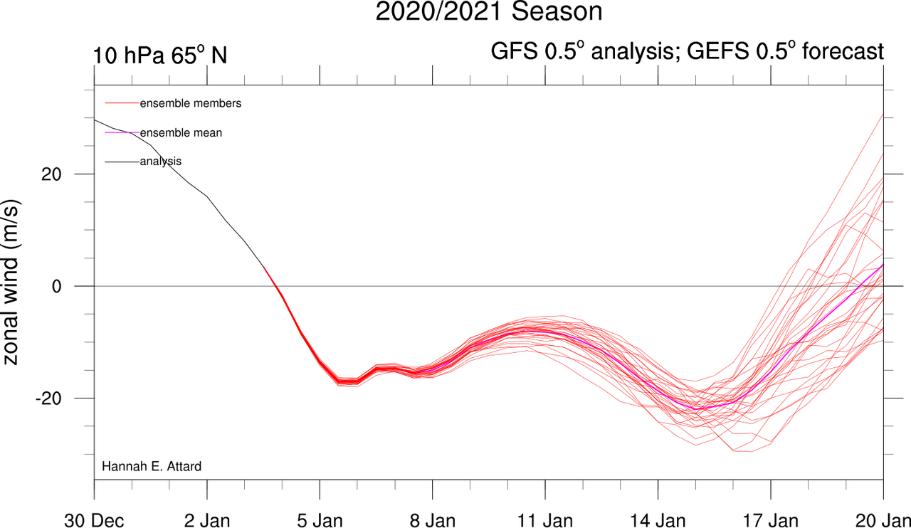
1/ I pointed this out in the yesterday's blog. I don't recall ever seeing the maximum of positive polar cap geopotential anomalies successfully complete a "U" shape in the stratosphere before. I know this is complicated but potentially very significant. pic.twitter.com/tPDuykTgvg
— Judah Cohen (@judah47) January 5, 2021
This screams Polar Vortex Disruption that could have 30-60 days affects if it lasts this long
_________________
Mugs
AKA:King: Snow Weenie
Self Proclaimed
WINTER 2014-15 : 55.12" +.02 for 6 coatings (avg. 35")
WINTER 2015-16 Total - 29.8" (Avg 35")
WINTER 2016-17 : 39.5" so far
amugs- Advanced Forecaster - Mod
- Posts : 15093
Reputation : 213
Join date : 2013-01-07
Age : 54
Location : Hillsdale,NJ
Frank_Wx likes this post
Re: Long Range Discussion 20(20) (Ha!)
![]() by Frank_Wx Tue Jan 05, 2021 2:03 pm
by Frank_Wx Tue Jan 05, 2021 2:03 pm
The event on 1/9 is not going to pan out.
_________________
_______________________________________________________________________________________________________
CLICK HERE to view NJ Strong Snowstorm Classifications
Frank_Wx- Godzilla Seeker
- Posts : 21305
Reputation : 328
Join date : 2013-01-05
Age : 31
Location : Jersey City, NJ -
Re: Long Range Discussion 20(20) (Ha!)
![]() by Frank_Wx Tue Jan 05, 2021 2:04 pm
by Frank_Wx Tue Jan 05, 2021 2:04 pm
_________________
_______________________________________________________________________________________________________
CLICK HERE to view NJ Strong Snowstorm Classifications
Frank_Wx- Godzilla Seeker
- Posts : 21305
Reputation : 328
Join date : 2013-01-05
Age : 31
Location : Jersey City, NJ -
weatherwatchermom likes this post
Re: Long Range Discussion 20(20) (Ha!)
![]() by heehaw453 Tue Jan 05, 2021 2:10 pm
by heehaw453 Tue Jan 05, 2021 2:10 pm

heehaw453- Advanced Forecaster
- Posts : 3906
Reputation : 86
Join date : 2014-01-20
Location : Bedminster Township, PA Elevation 600' ASL
Judy Margolis likes this post
Re: Long Range Discussion 20(20) (Ha!)
![]() by essexcountypete Tue Jan 05, 2021 2:57 pm
by essexcountypete Tue Jan 05, 2021 2:57 pm
Frank_Wx wrote:Also, the mobile version of this forum is so much better than trying to use the desktop version on your phone. It only took me three years to figure that one out.
Mobile version, meaning there's an app?

essexcountypete- Pro Enthusiast

- Posts : 783
Reputation : 12
Join date : 2013-12-09
Location : Bloomfield, NJ
Re: Long Range Discussion 20(20) (Ha!)
![]() by Frank_Wx Tue Jan 05, 2021 6:26 pm
by Frank_Wx Tue Jan 05, 2021 6:26 pm
essexcountypete wrote:Frank_Wx wrote:Also, the mobile version of this forum is so much better than trying to use the desktop version on your phone. It only took me three years to figure that one out.
Mobile version, meaning there's an app?
No app.
But if you’re on the desktop version using your phone, in the bottom right of the page you should see a mobile version option. If you’re already using mobile version then in the upper right you should see a menu where you can select web version. But mobile >>> web
Frank_Wx- Godzilla Seeker
- Posts : 21305
Reputation : 328
Join date : 2013-01-05
Age : 31
Location : Jersey City, NJ -
Re: Long Range Discussion 20(20) (Ha!)
![]() by Frank_Wx Tue Jan 05, 2021 7:16 pm
by Frank_Wx Tue Jan 05, 2021 7:16 pm
https://www.washingtonpost.com/weather/2021/01/05/polar-vortex-split-cold-snow/?outputType=amp
_________________
_______________________________________________________________________________________________________
CLICK HERE to view NJ Strong Snowstorm Classifications
Frank_Wx- Godzilla Seeker
- Posts : 21305
Reputation : 328
Join date : 2013-01-05
Age : 31
Location : Jersey City, NJ -
Page 18 of 30 • 1 ... 10 ... 17, 18, 19 ... 24 ... 30 ![]()
|
|
|