
 Search
DECEMBER 16th 17th 2020 Snow Threat???
Page 16 of 24 •  1 ... 9 ... 15, 16, 17 ... 20 ... 24
 ![]()
Re: DECEMBER 16th 17th 2020 Snow Threat???
![]() by jmanley32 Mon Dec 14, 2020 9:29 am
by jmanley32 Mon Dec 14, 2020 9:29 am
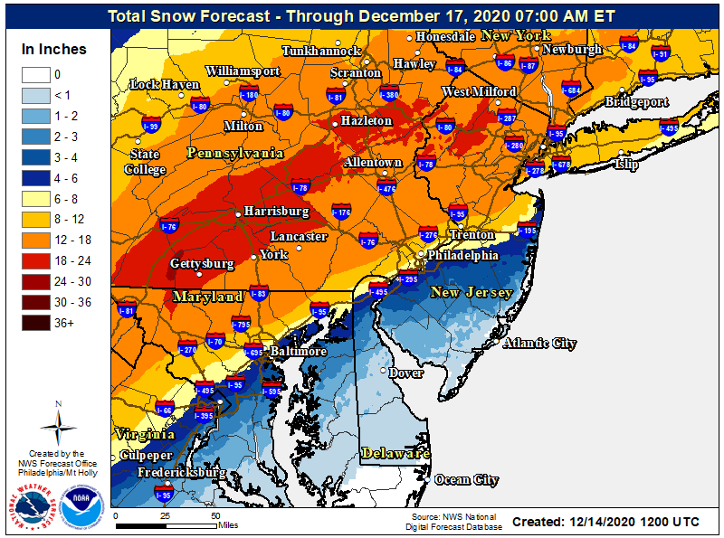
Wow, where did you get that? I do not even care that I am not in the red, 12-18 is amazing, even 6-12 is awesome to be talking area wide. I just have a hinkering that it will be widespread 12+.Frank_Wx wrote:NWS is not messing around. Area wide Godzilla
jmanley32- Senior Enthusiast

- Posts : 20513
Join date : 2013-12-12
Re: DECEMBER 16th 17th 2020 Snow Threat???
![]() by nutleyblizzard Mon Dec 14, 2020 9:29 am
by nutleyblizzard Mon Dec 14, 2020 9:29 am
nutleyblizzard- Senior Enthusiast
- Posts : 1952
Join date : 2014-01-30
Re: DECEMBER 16th 17th 2020 Snow Threat???
![]() by SoulSingMG Mon Dec 14, 2020 9:30 am
by SoulSingMG Mon Dec 14, 2020 9:30 am
jmanley32 wrote:Yeah thats the K ratio, I would take that with less than a grain of salt, the movement of the Euro to take the city into the 6-8 inch range makes it very hard for be to believe 24+ on rgem, but who knows maybe the SR know something the LR do not, we are getting into SR soon.SoulSingMG wrote:
6z RGEM drops the hammer on NYC.

Definitely a pipe dream snow map, buuuut I like the RGEM at this range and it’s been wicked consistent for 24 hrs. Big 12z runs coming; NAM already looks like she’s finding her way back south this run due to >er confluence.

SoulSingMG- Senior Enthusiast
- Posts : 2853
Reputation : 74
Join date : 2013-12-11
Location : Long Island City, NY
Re: DECEMBER 16th 17th 2020 Snow Threat???
![]() by jmanley32 Mon Dec 14, 2020 9:32 am
by jmanley32 Mon Dec 14, 2020 9:32 am

jmanley32- Senior Enthusiast
- Posts : 20513
Reputation : 108
Join date : 2013-12-12
Age : 42
Location : Yonkers, NY
Re: DECEMBER 16th 17th 2020 Snow Threat???
![]() by bobjohnsonforthehall Mon Dec 14, 2020 9:34 am
by bobjohnsonforthehall Mon Dec 14, 2020 9:34 am
jmanley32 wrote:At hr 60 NAM is a bit more east of the 06z, I think that could bode well.
Indeed. Confluence seems better. If NAM moves a fair amount I would discount looking at it at all until maybe 36 hours out. When it is very consistent this far out it needs to be considered. If it waffles, toss it until it is in close range.

bobjohnsonforthehall- Posts : 311
Reputation : 19
Join date : 2016-10-02
Location : Flemington NJ
Re: DECEMBER 16th 17th 2020 Snow Threat???
![]() by billg315 Mon Dec 14, 2020 9:34 am
by billg315 Mon Dec 14, 2020 9:34 am

billg315- Advanced Forecaster - Mod

- Posts : 4462
Reputation : 185
Join date : 2015-01-24
Age : 50
Location : Flemington, NJ
Re: DECEMBER 16th 17th 2020 Snow Threat???
![]() by Frank_Wx Mon Dec 14, 2020 9:36 am
by Frank_Wx Mon Dec 14, 2020 9:36 am
_________________
_______________________________________________________________________________________________________
CLICK HERE to view NJ Strong Snowstorm Classifications

Frank_Wx- Godzilla Seeker

- Posts : 21305
Reputation : 328
Join date : 2013-01-05
Age : 31
Location : Jersey City, NJ -

rb924119 likes this post
Re: DECEMBER 16th 17th 2020 Snow Threat???
![]() by billg315 Mon Dec 14, 2020 9:37 am
by billg315 Mon Dec 14, 2020 9:37 am
billg315- Advanced Forecaster - Mod
- Posts : 4462
Reputation : 185
Join date : 2015-01-24
Age : 50
Location : Flemington, NJ
Re: DECEMBER 16th 17th 2020 Snow Threat???
![]() by algae888 Mon Dec 14, 2020 9:43 am
by algae888 Mon Dec 14, 2020 9:43 am
It's still the nam at 60 plus hours. I'll take it more seriously tomorrow at 12 Z sometimes it does get systems right but most of the time it's too amped up it is definitely the Western edge of guidance which would be a good thing because I still think the entire Tri-State area gets at least 6 inches of snow whether or not we mix or change to rain or dry slot that is a significant snow storm for DecemberFrank_Wx wrote:In my opinion, the small shift S-SE on the NAM was not enough. The general idea is we get very heavy snow before dry slotting and/or changeover to mix. It's still a big difference compared to just 24 hours ago.
Last edited by algae888 on Mon Dec 14, 2020 9:45 am; edited 2 times in total

algae888- Advanced Forecaster

- Posts : 5311
Reputation : 46
Join date : 2013-02-05
Age : 61
Location : mt. vernon, new york
Re: DECEMBER 16th 17th 2020 Snow Threat???
![]() by rb924119 Mon Dec 14, 2020 9:44 am
by rb924119 Mon Dec 14, 2020 9:44 am
Frank_Wx wrote:In my opinion, the small shift S-SE on the NAM was not enough. The general idea is we get very heavy snow before dry slotting and/or changeover to mix. It's still a big difference compared to just 24 hours ago.
Agree, Frank. The surface depictions are wrong, I don’t know what else to say. You have mid-level closed lows passing to our west/overhead and then even northwest of us at H5, embedded in deep-layer southwesterly flow; you aren’t going to magically see those circulations stop dead and jump due east. Sorry. If anything, they will eventually arc, but not before they reach and/or exceed our latitude. And this is actually projected quite well on the QPF maps getting the banding well to our north and west with the dry slot showing up for us. People can say that it shifted east and colder, but dynamically speaking it didn’t at all. And, in these setups, warm air advancement aloft always outpaces modeling, so I would a quicker transition from snow to slop.
rb924119- Meteorologist

- Posts : 6889
Reputation : 194
Join date : 2013-02-06
Age : 32
Location : Greentown, Pa
Re: DECEMBER 16th 17th 2020 Snow Threat???
![]() by jmanley32 Mon Dec 14, 2020 9:45 am
by jmanley32 Mon Dec 14, 2020 9:45 am
Southern westchester which is like 10-15 miles north of NYC on the snow map sees close to 12, thats nothinbg to scoff at but it is def razor thin, but the mix never actually makes it up that far on TT anyways.billg315 wrote:12z NAM keeps the surface Low tucked in over the Delmarva and right on the NJ coast with significant mixing issues all the way up to just north of NYC proper and Long Island. Most significant accumulations limited to north of I-78. Still brings about 6-12" of snow to most people north of I-78, but the cut-off goes from like a foot of snow north to about a couple inches in about a 5-10 mile range. That is sharp.
jmanley32- Senior Enthusiast
- Posts : 20513
Reputation : 108
Join date : 2013-12-12
Age : 42
Location : Yonkers, NY
Re: DECEMBER 16th 17th 2020 Snow Threat???
![]() by jmanley32 Mon Dec 14, 2020 9:47 am
by jmanley32 Mon Dec 14, 2020 9:47 am
No slop lease, theres nothing i hate more in terms of weather. Well a cold nasty rain i guess. If its super windy slop could also mean power outages and wind maps are impressive, not sure how with such a weak LP but many see gusts 40-55mph for a period Wed Night.rb924119 wrote:Frank_Wx wrote:In my opinion, the small shift S-SE on the NAM was not enough. The general idea is we get very heavy snow before dry slotting and/or changeover to mix. It's still a big difference compared to just 24 hours ago.
Agree, Frank. The surface depictions are wrong, I don’t know what else to say. You have mid-level closed lows passing to our west/overhead and then even northwest of us at H5, embedded in deep-layer southwesterly flow; you aren’t going to magically see those circulations stop dead and jump due east. Sorry. If anything, they will eventually arc, but not before they reach and/or exceed our latitude. And this is actually projected quite well on the QPF maps getting the banding well to our north and west with the dry slot showing up for us. People can say that it shifted east and colder, but dynamically speaking it didn’t at all. And, in these setups, warm air advancement aloft always outpaces modeling, so I would a quicker transition from snow to slop.
Last edited by jmanley32 on Mon Dec 14, 2020 9:53 am; edited 1 time in total
jmanley32- Senior Enthusiast
- Posts : 20513
Reputation : 108
Join date : 2013-12-12
Age : 42
Location : Yonkers, NY
Re: DECEMBER 16th 17th 2020 Snow Threat???
![]() by jmanley32 Mon Dec 14, 2020 9:50 am
by jmanley32 Mon Dec 14, 2020 9:50 am

jmanley32- Senior Enthusiast
- Posts : 20513
Reputation : 108
Join date : 2013-12-12
Age : 42
Location : Yonkers, NY
Re: DECEMBER 16th 17th 2020 Snow Threat???
![]() by aiannone Mon Dec 14, 2020 9:55 am
by aiannone Mon Dec 14, 2020 9:55 am
_________________
-Alex Iannone-

aiannone- Senior Enthusiast - Mod
- Posts : 4813
Reputation : 92
Join date : 2013-01-07
Location : Saint James, LI (Northwest Suffolk Co.)
Re: DECEMBER 16th 17th 2020 Snow Threat???
![]() by jmanley32 Mon Dec 14, 2020 9:56 am
by jmanley32 Mon Dec 14, 2020 9:56 am
This seems to be going from a godzilla to maybe a mothreazilla for a lot of people....I hope it changes.aiannone wrote:Bernie's latest video saying 3-6" for LI due to significant mixing and NYC hes concerned won't see more than 6"
jmanley32- Senior Enthusiast
- Posts : 20513
Reputation : 108
Join date : 2013-12-12
Age : 42
Location : Yonkers, NY
Re: DECEMBER 16th 17th 2020 Snow Threat???
![]() by Frank_Wx Mon Dec 14, 2020 9:58 am
by Frank_Wx Mon Dec 14, 2020 9:58 am
aiannone wrote:Bernie's latest video saying 3-6" for LI due to significant mixing and NYC hes concerned won't see more than 6"
On the low side for sure, but at this juncture, I agree there will be either significant mixing or dry slotting that occurs for the coast unless trends today quickly reverse.
_________________
_______________________________________________________________________________________________________
CLICK HERE to view NJ Strong Snowstorm Classifications
Frank_Wx- Godzilla Seeker
- Posts : 21305
Reputation : 328
Join date : 2013-01-05
Age : 31
Location : Jersey City, NJ -
rb924119 likes this post
Re: DECEMBER 16th 17th 2020 Snow Threat???
![]() by nutleyblizzard Mon Dec 14, 2020 10:01 am
by nutleyblizzard Mon Dec 14, 2020 10:01 am
I have to disagree with you RB. We have a strong high along with a powerhouse 50/50 low. I can’t see a primary low plow right into that. The Nam showed some improvements with stronger confluence and a bit better H5 setup. I take it as a positive for us. Man I love this hobby. Onto the Gfs.rb924119 wrote:Frank_Wx wrote:In my opinion, the small shift S-SE on the NAM was not enough. The general idea is we get very heavy snow before dry slotting and/or changeover to mix. It's still a big difference compared to just 24 hours ago.
Agree, Frank. The surface depictions are wrong, I don’t know what else to say. You have mid-level closed lows passing to our west/overhead and then even northwest of us at H5, embedded in deep-layer southwesterly flow; you aren’t going to magically see those circulations stop dead and jump due east. Sorry. If anything, they will eventually arc, but not before they reach and/or exceed our latitude. And this is actually projected quite well on the QPF maps getting the banding well to our north and west with the dry slot showing up for us. People can say that it shifted east and colder, but dynamically speaking it didn’t at all. And, in these setups, warm air advancement aloft always outpaces modeling, so I would a quicker transition from snow to slop.

nutleyblizzard- Senior Enthusiast
- Posts : 1952
Reputation : 41
Join date : 2014-01-30
Age : 58
Location : Nutley, new jersey
SoulSingMG likes this post
Re: DECEMBER 16th 17th 2020 Snow Threat???
![]() by bobjohnsonforthehall Mon Dec 14, 2020 10:02 am
by bobjohnsonforthehall Mon Dec 14, 2020 10:02 am
bobjohnsonforthehall- Posts : 311
Reputation : 19
Join date : 2016-10-02
Location : Flemington NJ
Re: DECEMBER 16th 17th 2020 Snow Threat???
![]() by jmanley32 Mon Dec 14, 2020 10:07 am
by jmanley32 Mon Dec 14, 2020 10:07 am
Even syracuse sees 6 plus inches!!bobjohnsonforthehall wrote:I don't see how those totals in Upstate NY verify. That high is no joke. Tough for me to see Albany get anywhere near the 14/15 inch line.
jmanley32- Senior Enthusiast
- Posts : 20513
Reputation : 108
Join date : 2013-12-12
Age : 42
Location : Yonkers, NY
Re: DECEMBER 16th 17th 2020 Snow Threat???
![]() by dsix85 Mon Dec 14, 2020 10:09 am
by dsix85 Mon Dec 14, 2020 10:09 am
dsix85- Pro Enthusiast

- Posts : 349
Reputation : 8
Join date : 2014-01-01
Location : New York
Re: DECEMBER 16th 17th 2020 Snow Threat???
![]() by aiannone Mon Dec 14, 2020 10:14 am
by aiannone Mon Dec 14, 2020 10:14 am
_________________
-Alex Iannone-
aiannone- Senior Enthusiast - Mod
- Posts : 4813
Reputation : 92
Join date : 2013-01-07
Location : Saint James, LI (Northwest Suffolk Co.)
Re: DECEMBER 16th 17th 2020 Snow Threat???
![]() by aiannone Mon Dec 14, 2020 10:16 am
by aiannone Mon Dec 14, 2020 10:16 am
_________________
-Alex Iannone-
aiannone- Senior Enthusiast - Mod
- Posts : 4813
Reputation : 92
Join date : 2013-01-07
Location : Saint James, LI (Northwest Suffolk Co.)
Re: DECEMBER 16th 17th 2020 Snow Threat???
![]() by nutleyblizzard Mon Dec 14, 2020 10:17 am
by nutleyblizzard Mon Dec 14, 2020 10:17 am
Models have a tendency to underestimate confluence. I expect continued corrections South and east although I believe the GFS is too far south.dsix85 wrote:Any chance we are seeing the windshield wiper effect? Models inconsistent?
nutleyblizzard- Senior Enthusiast
- Posts : 1952
Reputation : 41
Join date : 2014-01-30
Age : 58
Location : Nutley, new jersey
Re: DECEMBER 16th 17th 2020 Snow Threat???
![]() by aiannone Mon Dec 14, 2020 10:18 am
by aiannone Mon Dec 14, 2020 10:18 am
aiannone wrote:ICON mostly rain for NYC and LI. Mixing in NNJ and SCT otherwise jackpot is up towards 684

_________________
-Alex Iannone-
aiannone- Senior Enthusiast - Mod
- Posts : 4813
Reputation : 92
Join date : 2013-01-07
Location : Saint James, LI (Northwest Suffolk Co.)
Re: DECEMBER 16th 17th 2020 Snow Threat???
![]() by Irish Mon Dec 14, 2020 10:25 am
by Irish Mon Dec 14, 2020 10:25 am
SoulSingMG wrote:jmanley32 wrote:Yeah thats the K ratio, I would take that with less than a grain of salt, the movement of the Euro to take the city into the 6-8 inch range makes it very hard for be to believe 24+ on rgem, but who knows maybe the SR know something the LR do not, we are getting into SR soon.SoulSingMG wrote:
6z RGEM drops the hammer on NYC.
Definitely a pipe dream snow map, buuuut I like the RGEM at this range and it’s been wicked consistent for 24 hrs. Big 12z runs coming; NAM already looks like she’s finding her way back south this run due to >er confluence.
Could the GFS been right on their call of this storm? Models look to be veering toward a more SE run, which makes sense with the blocking.

Irish- Pro Enthusiast
- Posts : 788
Reputation : 19
Join date : 2019-01-16
Age : 45
Location : Old Bridge, NJ
Re: DECEMBER 16th 17th 2020 Snow Threat???
![]() by aiannone Mon Dec 14, 2020 10:27 am
by aiannone Mon Dec 14, 2020 10:27 am

_________________
-Alex Iannone-
aiannone- Senior Enthusiast - Mod
- Posts : 4813
Reputation : 92
Join date : 2013-01-07
Location : Saint James, LI (Northwest Suffolk Co.)
Re: DECEMBER 16th 17th 2020 Snow Threat???
![]() by rb924119 Mon Dec 14, 2020 10:33 am
by rb924119 Mon Dec 14, 2020 10:33 am
nutleyblizzard wrote:I have to disagree with you RB. We have a strong high along with a powerhouse 50/50 low. I can’t see a primary low plow right into that. The Nam showed some improvements with stronger confluence and a bit better H5 setup. I take it as a positive for us. Man I love this hobby. Onto the Gfs.rb924119 wrote:Frank_Wx wrote:In my opinion, the small shift S-SE on the NAM was not enough. The general idea is we get very heavy snow before dry slotting and/or changeover to mix. It's still a big difference compared to just 24 hours ago.
Agree, Frank. The surface depictions are wrong, I don’t know what else to say. You have mid-level closed lows passing to our west/overhead and then even northwest of us at H5, embedded in deep-layer southwesterly flow; you aren’t going to magically see those circulations stop dead and jump due east. Sorry. If anything, they will eventually arc, but not before they reach and/or exceed our latitude. And this is actually projected quite well on the QPF maps getting the banding well to our north and west with the dry slot showing up for us. People can say that it shifted east and colder, but dynamically speaking it didn’t at all. And, in these setups, warm air advancement aloft always outpaces modeling, so I would a quicker transition from snow to slop.
That’s fine, you can disagree, I won’t get upset
rb924119- Meteorologist
- Posts : 6889
Reputation : 194
Join date : 2013-02-06
Age : 32
Location : Greentown, Pa
Page 16 of 24 • 1 ... 9 ... 15, 16, 17 ... 20 ... 24 ![]()
|
|
|