
 Search
DECEMBER 16th 17th 2020 Snow Threat???
Page 9 of 24 •  1 ... 6 ... 8, 9, 10 ... 16 ... 24
 ![]()
Re: DECEMBER 16th 17th 2020 Snow Threat???
![]() by jmanley32 Sun Dec 13, 2020 1:30 pm
by jmanley32 Sun Dec 13, 2020 1:30 pm
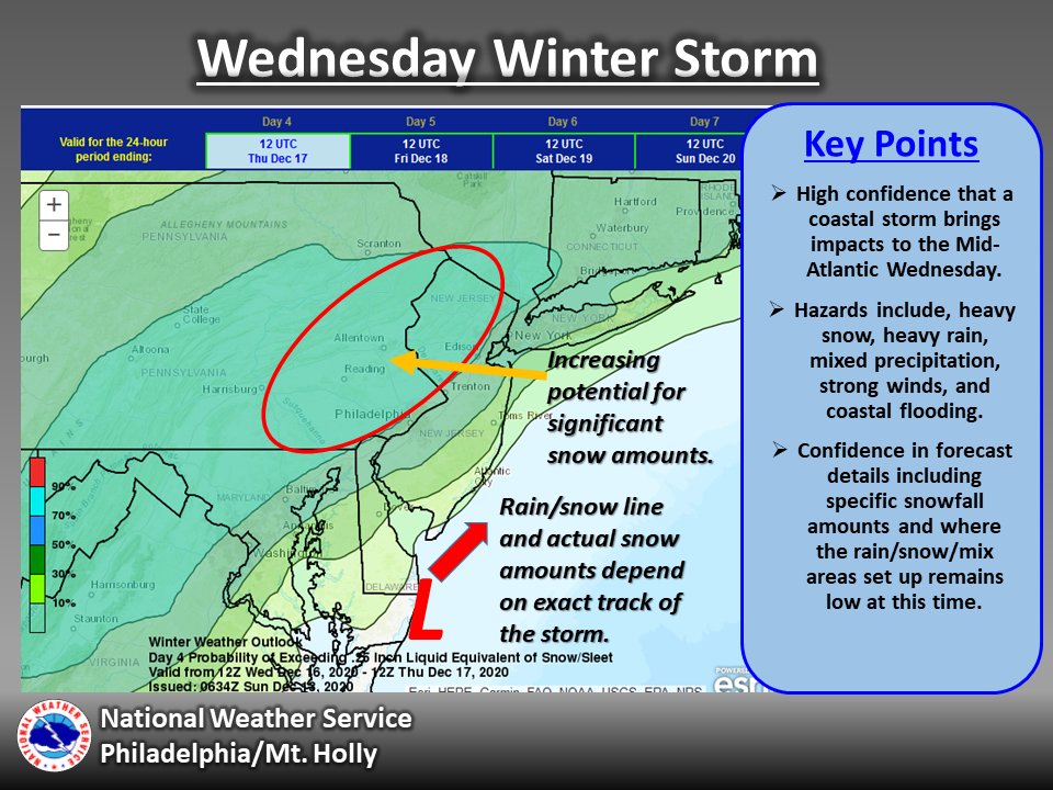
fRANK If I see 20.1 inches of snow on Wed which is right over me on that map I will not complain the rest of the winter, thats nearly our yearly average on one day!! You may have to put back the roidzilla potential if the Euro holds, if the GFS trends that way it would be even better!! Cannot wait to see the SR models in a day or 2.Frank_Wx wrote:That euro run was crazy. Wow
jmanley32- Senior Enthusiast

- Posts : 20513
Join date : 2013-12-12
Re: DECEMBER 16th 17th 2020 Snow Threat???
![]() by algae888 Sun Dec 13, 2020 1:32 pm
by algae888 Sun Dec 13, 2020 1:32 pm
algae888- Advanced Forecaster

- Posts : 5311
Join date : 2013-02-05
Re: DECEMBER 16th 17th 2020 Snow Threat???
![]() by Irish Sun Dec 13, 2020 1:34 pm
by Irish Sun Dec 13, 2020 1:34 pm

Irish- Pro Enthusiast

- Posts : 788
Reputation : 19
Join date : 2019-01-16
Age : 45
Location : Old Bridge, NJ
Re: DECEMBER 16th 17th 2020 Snow Threat???
![]() by jmanley32 Sun Dec 13, 2020 1:35 pm
by jmanley32 Sun Dec 13, 2020 1:35 pm

jmanley32- Senior Enthusiast
- Posts : 20513
Reputation : 108
Join date : 2013-12-12
Age : 42
Location : Yonkers, NY
Re: DECEMBER 16th 17th 2020 Snow Threat???
![]() by jmanley32 Sun Dec 13, 2020 1:37 pm
by jmanley32 Sun Dec 13, 2020 1:37 pm
It was stated it might only be 8:1, you think it'll be higher.algae888 wrote:Don't forget the snow Maps are 10 to 1 ratios there's going to be higher ratios with the CCB bands
jmanley32- Senior Enthusiast
- Posts : 20513
Reputation : 108
Join date : 2013-12-12
Age : 42
Location : Yonkers, NY
Re: DECEMBER 16th 17th 2020 Snow Threat???
![]() by nutleyblizzard Sun Dec 13, 2020 1:40 pm
by nutleyblizzard Sun Dec 13, 2020 1:40 pm

nutleyblizzard- Senior Enthusiast
- Posts : 1952
Reputation : 41
Join date : 2014-01-30
Age : 58
Location : Nutley, new jersey
Re: DECEMBER 16th 17th 2020 Snow Threat???
![]() by jmanley32 Sun Dec 13, 2020 1:42 pm
by jmanley32 Sun Dec 13, 2020 1:42 pm
I hope so, that would be fantastic. CMC as i said also was a good blow to the area with many seeing godzilla totals, I think this may still have roid potential especially where they Euro has the highest snows, gonna be a exciting few days of tracking, im just glad its 3 days out and not 7 or more. Not even 3 days, in 3 days it will be starting to snow if it is on time.nutleyblizzard wrote:Good to see the Euro back off with the tucked in solution. What the 12z Euro depicts is the perfect track. I expect the GFS to correct NW in time.
jmanley32- Senior Enthusiast
- Posts : 20513
Reputation : 108
Join date : 2013-12-12
Age : 42
Location : Yonkers, NY
Re: DECEMBER 16th 17th 2020 Snow Threat???
![]() by sroc4 Sun Dec 13, 2020 1:47 pm
by sroc4 Sun Dec 13, 2020 1:47 pm
jmanley32 wrote:It was stated it might only be 8:1, you think it'll be higher.algae888 wrote:Don't forget the snow Maps are 10 to 1 ratios there's going to be higher ratios with the CCB bands
It will be higher than 8:1 in most locations. Maybe near the RS line but that’s it. Once you are 20 miles away from the Rs line ratios jump. Very cold air mass. rs line sees the most QPF but just to the north sees the highest ratios.
_________________
"In weather and in life, there's no winning and losing; there's only winning and learning."
WINTER 2012/2013 TOTALS 43.65"WINTER 2017/2018 TOTALS 62.85" WINTER 2022/2023 TOTALS 4.9"
WINTER 2013/2014 TOTALS 64.85"WINTER 2018/2019 TOTALS 14.25" WINTER 2023/2024 TOTALS 13.1"
WINTER 2014/2015 TOTALS 71.20"WINTER 2019/2020 TOTALS 6.35"
WINTER 2015/2016 TOTALS 35.00"WINTER 2020/2021 TOTALS 37.75"
WINTER 2016/2017 TOTALS 42.25"WINTER 2021/2022 TOTALS 31.65"

sroc4- Admin

- Posts : 8331
Reputation : 301
Join date : 2013-01-07
Location : Wading River, LI
Re: DECEMBER 16th 17th 2020 Snow Threat???
![]() by heehaw453 Sun Dec 13, 2020 1:48 pm
by heehaw453 Sun Dec 13, 2020 1:48 pm
Look at the tilt of the 500 trough. Just throwing all the Atlantic moisture of a cold dome of air. Classic.
Euro 500 MB

Euro 850 MB

heehaw453- Advanced Forecaster
- Posts : 3906
Reputation : 86
Join date : 2014-01-20
Location : Bedminster Township, PA Elevation 600' ASL
Re: DECEMBER 16th 17th 2020 Snow Threat???
![]() by Frank_Wx Sun Dec 13, 2020 1:49 pm
by Frank_Wx Sun Dec 13, 2020 1:49 pm
algae888 wrote:Don't forget the snow Maps are 10 to 1 ratios there's going to be higher ratios with the CCB bands
Yes but also keep in mind the dry air at the onset of the storm
will eat some of the precip. It will take some time for the air
to get saturated.
_________________
_______________________________________________________________________________________________________
CLICK HERE to view NJ Strong Snowstorm Classifications

Frank_Wx- Godzilla Seeker
- Posts : 21305
Reputation : 328
Join date : 2013-01-05
Age : 31
Location : Jersey City, NJ -

Re: DECEMBER 16th 17th 2020 Snow Threat???
![]() by MattyICE Sun Dec 13, 2020 1:49 pm
by MattyICE Sun Dec 13, 2020 1:49 pm
MattyICE- Advanced Forecaster
- Posts : 249
Reputation : 6
Join date : 2017-11-10
Age : 38
Location : Clifton, NJ (Eastern Passaic County)
sroc4 likes this post
Re: DECEMBER 16th 17th 2020 Snow Threat???
![]() by Frank_Wx Sun Dec 13, 2020 1:49 pm
by Frank_Wx Sun Dec 13, 2020 1:49 pm
heehaw453 wrote:LOL! Euro closes at 850 and just meanders. That's a recipe for extreme accumulations given the cold and that track.
Look at the tilt of the 500 trough. Just throwing all the Atlantic moisture of a cold dome of air. Classic.
Euro 500 MB
Euro 850 MB
Can you post 700mb?
_________________
_______________________________________________________________________________________________________
CLICK HERE to view NJ Strong Snowstorm Classifications
Frank_Wx- Godzilla Seeker
- Posts : 21305
Reputation : 328
Join date : 2013-01-05
Age : 31
Location : Jersey City, NJ -
Re: DECEMBER 16th 17th 2020 Snow Threat???
![]() by Frank_Wx Sun Dec 13, 2020 1:51 pm
by Frank_Wx Sun Dec 13, 2020 1:51 pm
MattyICE wrote:I think ratios will be complicated. Lot of ifs, but if the 50/50 low ends up as strong as modeled and the High in SE Canada as well that CAD will not only be legit, it will be undermodeled by the globals as frequently happens. This is a true arctic-sourced high, so areas that end up benefiting from these processes can certainly exceed 10:1 ratios. Heavy winds could also cut down ratios but, again, we know how frequently they DON’T mix down to the surface. Is 8:1 possible? I suppose for more southern portions of the board...but I think 10:1+ is much more likely. These are all details that will be handled better by the mesoscale models and sounding analysis probably starting Monday evening and beyond. Just my two cents.
Great post and I agree
_________________
_______________________________________________________________________________________________________
CLICK HERE to view NJ Strong Snowstorm Classifications
Frank_Wx- Godzilla Seeker
- Posts : 21305
Reputation : 328
Join date : 2013-01-05
Age : 31
Location : Jersey City, NJ -
MattyICE and phil155 like this post
Re: DECEMBER 16th 17th 2020 Snow Threat???
![]() by heehaw453 Sun Dec 13, 2020 1:58 pm
by heehaw453 Sun Dec 13, 2020 1:58 pm
heehaw453- Advanced Forecaster
- Posts : 3906
Reputation : 86
Join date : 2014-01-20
Location : Bedminster Township, PA Elevation 600' ASL
Re: DECEMBER 16th 17th 2020 Snow Threat???
![]() by hyde345 Sun Dec 13, 2020 2:01 pm
by hyde345 Sun Dec 13, 2020 2:01 pm

hyde345- Pro Enthusiast
- Posts : 1082
Reputation : 48
Join date : 2013-01-08
Location : Hyde Park, NY
Re: DECEMBER 16th 17th 2020 Snow Threat???
![]() by SoulSingMG Sun Dec 13, 2020 2:03 pm
by SoulSingMG Sun Dec 13, 2020 2:03 pm

Depicts a legit b******* for NYC metro.

SoulSingMG- Senior Enthusiast
- Posts : 2853
Reputation : 74
Join date : 2013-12-11
Location : Long Island City, NY
Re: DECEMBER 16th 17th 2020 Snow Threat???
![]() by heehaw453 Sun Dec 13, 2020 2:03 pm
by heehaw453 Sun Dec 13, 2020 2:03 pm
Frank_Wx wrote:heehaw453 wrote:LOL! Euro closes at 850 and just meanders. That's a recipe for extreme accumulations given the cold and that track.
Look at the tilt of the 500 trough. Just throwing all the Atlantic moisture of a cold dome of air. Classic.
Euro 500 MB
Euro 850 MB
Can you post 700mb?

heehaw453- Advanced Forecaster
- Posts : 3906
Reputation : 86
Join date : 2014-01-20
Location : Bedminster Township, PA Elevation 600' ASL
Re: DECEMBER 16th 17th 2020 Snow Threat???
![]() by amugs Sun Dec 13, 2020 2:09 pm
by amugs Sun Dec 13, 2020 2:09 pm
_________________
Mugs
AKA:King: Snow Weenie
Self Proclaimed
WINTER 2014-15 : 55.12" +.02 for 6 coatings (avg. 35")
WINTER 2015-16 Total - 29.8" (Avg 35")
WINTER 2016-17 : 39.5" so far

amugs- Advanced Forecaster - Mod

- Posts : 15093
Reputation : 213
Join date : 2013-01-07
Age : 54
Location : Hillsdale,NJ
Re: DECEMBER 16th 17th 2020 Snow Threat???
![]() by heehaw453 Sun Dec 13, 2020 2:12 pm
by heehaw453 Sun Dec 13, 2020 2:12 pm
heehaw453- Advanced Forecaster
- Posts : 3906
Reputation : 86
Join date : 2014-01-20
Location : Bedminster Township, PA Elevation 600' ASL
Re: DECEMBER 16th 17th 2020 Snow Threat???
![]() by heehaw453 Sun Dec 13, 2020 2:14 pm
by heehaw453 Sun Dec 13, 2020 2:14 pm
amugs wrote:
That almost points to my house. lol
heehaw453- Advanced Forecaster
- Posts : 3906
Reputation : 86
Join date : 2014-01-20
Location : Bedminster Township, PA Elevation 600' ASL

SoulSingMG- Senior Enthusiast
- Posts : 2853
Reputation : 74
Join date : 2013-12-11
Location : Long Island City, NY
Re: DECEMBER 16th 17th 2020 Snow Threat???
![]() by amugs Sun Dec 13, 2020 2:19 pm
by amugs Sun Dec 13, 2020 2:19 pm


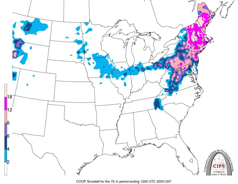
From Billy @ NSFWx
CIPS top analog for teh 500MB set up is...Dec 5, 2003
_________________
Mugs
AKA:King: Snow Weenie
Self Proclaimed
WINTER 2014-15 : 55.12" +.02 for 6 coatings (avg. 35")
WINTER 2015-16 Total - 29.8" (Avg 35")
WINTER 2016-17 : 39.5" so far
amugs- Advanced Forecaster - Mod
- Posts : 15093
Reputation : 213
Join date : 2013-01-07
Age : 54
Location : Hillsdale,NJ
Re: DECEMBER 16th 17th 2020 Snow Threat???
![]() by jmanley32 Sun Dec 13, 2020 2:19 pm
by jmanley32 Sun Dec 13, 2020 2:19 pm
Can't get much better confidence than that!!SoulSingMG wrote:ENS are stunning
jmanley32- Senior Enthusiast
- Posts : 20513
Reputation : 108
Join date : 2013-12-12
Age : 42
Location : Yonkers, NY
Re: DECEMBER 16th 17th 2020 Snow Threat???
![]() by amugs Sun Dec 13, 2020 2:21 pm
by amugs Sun Dec 13, 2020 2:21 pm
Last edited by amugs on Sun Dec 13, 2020 2:21 pm; edited 1 time in total
_________________
Mugs
AKA:King: Snow Weenie
Self Proclaimed
WINTER 2014-15 : 55.12" +.02 for 6 coatings (avg. 35")
WINTER 2015-16 Total - 29.8" (Avg 35")
WINTER 2016-17 : 39.5" so far
amugs- Advanced Forecaster - Mod
- Posts : 15093
Reputation : 213
Join date : 2013-01-07
Age : 54
Location : Hillsdale,NJ
Re: DECEMBER 16th 17th 2020 Snow Threat???
![]() by jmanley32 Sun Dec 13, 2020 2:21 pm
by jmanley32 Sun Dec 13, 2020 2:21 pm
What do the different shades mean? They do not color code with the bar, I am in the dark green, I presume thats good if I want a lot of snow.heehaw453 wrote:amugs wrote:
That almost points to my house. lol
jmanley32- Senior Enthusiast
- Posts : 20513
Reputation : 108
Join date : 2013-12-12
Age : 42
Location : Yonkers, NY
Re: DECEMBER 16th 17th 2020 Snow Threat???
![]() by jmanley32 Sun Dec 13, 2020 2:31 pm
by jmanley32 Sun Dec 13, 2020 2:31 pm
You just posted the ensemble snow map lol, 15 inches as a ensemble jesus that means there are some way higher dang!amugs wrote:EPS is a WOWZA
From Billy @ NSFWx
CIPS top analog for teh 500MB set up is...Dec 5, 2003
jmanley32- Senior Enthusiast
- Posts : 20513
Reputation : 108
Join date : 2013-12-12
Age : 42
Location : Yonkers, NY
Re: DECEMBER 16th 17th 2020 Snow Threat???
![]() by amugs Sun Dec 13, 2020 4:19 pm
by amugs Sun Dec 13, 2020 4:19 pm
_________________
Mugs
AKA:King: Snow Weenie
Self Proclaimed
WINTER 2014-15 : 55.12" +.02 for 6 coatings (avg. 35")
WINTER 2015-16 Total - 29.8" (Avg 35")
WINTER 2016-17 : 39.5" so far
amugs- Advanced Forecaster - Mod
- Posts : 15093
Reputation : 213
Join date : 2013-01-07
Age : 54
Location : Hillsdale,NJ
Page 9 of 24 • 1 ... 6 ... 8, 9, 10 ... 16 ... 24 ![]()
|
|
|