
 Search
DECEMBER 16th 17th 2020 Snow Threat???
Page 19 of 24 •  1 ... 11 ... 18, 19, 20 ... 24
 ![]()
Re: DECEMBER 16th 17th 2020 Snow Threat???
![]() by Irish Mon Dec 14, 2020 1:09 pm
by Irish Mon Dec 14, 2020 1:09 pm
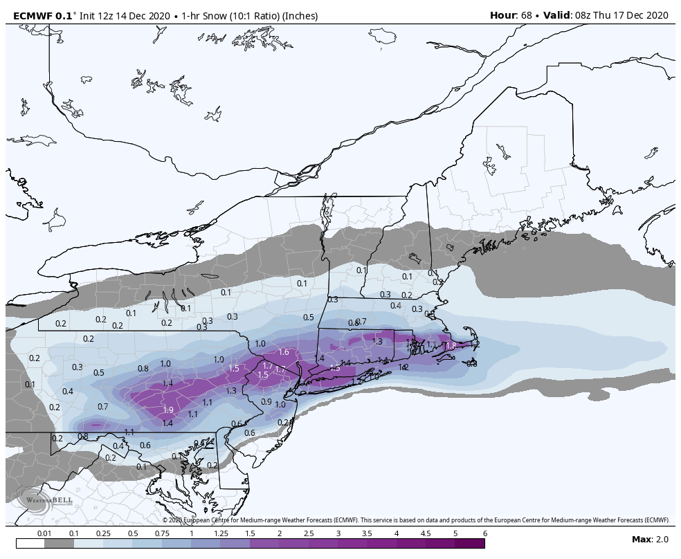
Frank_Wx wrote:Godzilla incoming

Just to learn, what is that showing?
Irish- Pro Enthusiast

- Posts : 788
Join date : 2019-01-16

aiannone- Senior Enthusiast - Mod

- Posts : 4813
Join date : 2013-01-07
Re: DECEMBER 16th 17th 2020 Snow Threat???
![]() by Frank_Wx Mon Dec 14, 2020 1:11 pm
by Frank_Wx Mon Dec 14, 2020 1:11 pm

_________________
_______________________________________________________________________________________________________
CLICK HERE to view NJ Strong Snowstorm Classifications

Frank_Wx- Godzilla Seeker

- Posts : 21305
Reputation : 328
Join date : 2013-01-05
Age : 31
Location : Jersey City, NJ -

Re: DECEMBER 16th 17th 2020 Snow Threat???
![]() by heehaw453 Mon Dec 14, 2020 1:13 pm
by heehaw453 Mon Dec 14, 2020 1:13 pm
Frank_Wx wrote:Wow, that was a huge run for our area. It is time to enter Godzilla Storm Mode
Please give me two helpings of what the Euro was dishing out just now. My goodness.
heehaw453- Advanced Forecaster

- Posts : 3906
Reputation : 86
Join date : 2014-01-20
Location : Bedminster Township, PA Elevation 600' ASL
Re: DECEMBER 16th 17th 2020 Snow Threat???
![]() by aiannone Mon Dec 14, 2020 1:14 pm
by aiannone Mon Dec 14, 2020 1:14 pm

_________________
-Alex Iannone-

aiannone- Senior Enthusiast - Mod
- Posts : 4813
Reputation : 92
Join date : 2013-01-07
Location : Saint James, LI (Northwest Suffolk Co.)
Re: DECEMBER 16th 17th 2020 Snow Threat???
![]() by Frank_Wx Mon Dec 14, 2020 1:16 pm
by Frank_Wx Mon Dec 14, 2020 1:16 pm

Godzilla Mode activated!
Write up and 1st call snow map will come tonight
_________________
_______________________________________________________________________________________________________
CLICK HERE to view NJ Strong Snowstorm Classifications
Frank_Wx- Godzilla Seeker
- Posts : 21305
Reputation : 328
Join date : 2013-01-05
Age : 31
Location : Jersey City, NJ -
heehaw453 likes this post
Re: DECEMBER 16th 17th 2020 Snow Threat???
![]() by sroc4 Mon Dec 14, 2020 1:16 pm
by sroc4 Mon Dec 14, 2020 1:16 pm
aiannone wrote:Godzilla mode must be activated!
Look at the 850mb closed low track and this is why the snow map shows what it does (South of LI). Not budging my stance. Off to surgery

_________________
"In weather and in life, there's no winning and losing; there's only winning and learning."
WINTER 2012/2013 TOTALS 43.65"WINTER 2017/2018 TOTALS 62.85" WINTER 2022/2023 TOTALS 4.9"
WINTER 2013/2014 TOTALS 64.85"WINTER 2018/2019 TOTALS 14.25" WINTER 2023/2024 TOTALS 13.1"
WINTER 2014/2015 TOTALS 71.20"WINTER 2019/2020 TOTALS 6.35"
WINTER 2015/2016 TOTALS 35.00"WINTER 2020/2021 TOTALS 37.75"
WINTER 2016/2017 TOTALS 42.25"WINTER 2021/2022 TOTALS 31.65"

sroc4- Admin
- Posts : 8331
Reputation : 301
Join date : 2013-01-07
Location : Wading River, LI
Re: DECEMBER 16th 17th 2020 Snow Threat???
![]() by bloc1357 Mon Dec 14, 2020 1:17 pm
by bloc1357 Mon Dec 14, 2020 1:17 pm
bloc1357- Pro Enthusiast
- Posts : 344
Reputation : 10
Join date : 2013-03-05
Age : 47
Location : West Babylon, NY - 11704
Re: DECEMBER 16th 17th 2020 Snow Threat???
![]() by SoulSingMG Mon Dec 14, 2020 1:18 pm
by SoulSingMG Mon Dec 14, 2020 1:18 pm


SoulSingMG- Senior Enthusiast

- Posts : 2853
Reputation : 74
Join date : 2013-12-11
Location : Long Island City, NY
Re: DECEMBER 16th 17th 2020 Snow Threat???
![]() by Frank_Wx Mon Dec 14, 2020 1:22 pm
by Frank_Wx Mon Dec 14, 2020 1:22 pm
Frontogenetically forced bands of heavy snow love to persist near a RN/SN line. Latent heat absorbed by melting snow in a warm nose offsets WAA while adjacent areas warm unabated >> enhanced local horizontal baroclinicity >> laterally prop. frontogenesis couples w/ rain-snow line pic.twitter.com/palS4gXarW
— Eric Webb (@webberweather) December 14, 2020
_________________
_______________________________________________________________________________________________________
CLICK HERE to view NJ Strong Snowstorm Classifications
Frank_Wx- Godzilla Seeker
- Posts : 21305
Reputation : 328
Join date : 2013-01-05
Age : 31
Location : Jersey City, NJ -
Re: DECEMBER 16th 17th 2020 Snow Threat???
![]() by Frank_Wx Mon Dec 14, 2020 1:24 pm
by Frank_Wx Mon Dec 14, 2020 1:24 pm
Do not bet against this high pressure. pic.twitter.com/sSYhrqccvN
— Mike Mostwill (@MikeMostwill) December 14, 2020
_________________
_______________________________________________________________________________________________________
CLICK HERE to view NJ Strong Snowstorm Classifications
Frank_Wx- Godzilla Seeker
- Posts : 21305
Reputation : 328
Join date : 2013-01-05
Age : 31
Location : Jersey City, NJ -
Re: DECEMBER 16th 17th 2020 Snow Threat???
![]() by bobjohnsonforthehall Mon Dec 14, 2020 1:27 pm
by bobjohnsonforthehall Mon Dec 14, 2020 1:27 pm
Frank_Wx wrote:700mb frontogenesis will be enhanced to a point of it leading to prolific snowfall rates of 2"+/hour. That is how the 1+ foot amounts will be realized. It is a fast moving system.Frontogenetically forced bands of heavy snow love to persist near a RN/SN line. Latent heat absorbed by melting snow in a warm nose offsets WAA while adjacent areas warm unabated >> enhanced local horizontal baroclinicity >> laterally prop. frontogenesis couples w/ rain-snow line pic.twitter.com/palS4gXarW
— Eric Webb (@webberweather) December 14, 2020
There does seem to be a stall for a few hours on the Euro.

bobjohnsonforthehall- Posts : 311
Reputation : 19
Join date : 2016-10-02
Location : Flemington NJ
Re: DECEMBER 16th 17th 2020 Snow Threat???
![]() by Frank_Wx Mon Dec 14, 2020 1:28 pm
by Frank_Wx Mon Dec 14, 2020 1:28 pm
Frank_Wx wrote:700mb frontogenesis will be enhanced to a point of it leading to prolific snowfall rates of 2"+/hour. That is how the 1+ foot amounts will be realized. It is a fast moving system.Frontogenetically forced bands of heavy snow love to persist near a RN/SN line. Latent heat absorbed by melting snow in a warm nose offsets WAA while adjacent areas warm unabated >> enhanced local horizontal baroclinicity >> laterally prop. frontogenesis couples w/ rain-snow line pic.twitter.com/palS4gXarW
— Eric Webb (@webberweather) December 14, 2020
Considering this is a 10:1 ratio map, I actually think snowfall rates might exceed 2 inches within this band on the EURO. This actually is starting to look more like a SWFE (southwest flow event) than a Nor'easter. No northern stream phasing, but the pressure gradients and WAA will induce incredible dynamics. Would not shock me to hear thundersnow.
_________________
_______________________________________________________________________________________________________
CLICK HERE to view NJ Strong Snowstorm Classifications
Frank_Wx- Godzilla Seeker
- Posts : 21305
Reputation : 328
Join date : 2013-01-05
Age : 31
Location : Jersey City, NJ -
Re: DECEMBER 16th 17th 2020 Snow Threat???
![]() by heehaw453 Mon Dec 14, 2020 1:29 pm
by heehaw453 Mon Dec 14, 2020 1:29 pm
Frank_Wx wrote:This is a nice tweet. It shows how the HP to the north has trended stronger in the last 12 hours on the EURO, hence why today's 12z run saw the track shift more S&E. If you notice on the snowfall maps, the extreme northern extent of our region, like NEPA into Binghamton, are no longer seeing the heaviest axis of snow.Do not bet against this high pressure. pic.twitter.com/sSYhrqccvN
— Mike Mostwill (@MikeMostwill) December 14, 2020
The cold press can often be underestimated. This 50/50 low is absolutely critical to the solution. Also, -AO helps so much with bleeding that cold air right out of Canada. Synoptically this setup looks good to me.
heehaw453- Advanced Forecaster
- Posts : 3906
Reputation : 86
Join date : 2014-01-20
Location : Bedminster Township, PA Elevation 600' ASL
Re: DECEMBER 16th 17th 2020 Snow Threat???
![]() by weatherwatchermom Mon Dec 14, 2020 1:33 pm
by weatherwatchermom Mon Dec 14, 2020 1:33 pm
Hope your day gets better..by the way I love my vet(her home number is in my phone) but if we lived closer I would bring my Fluffy(Brandy)to you!...you are so thorough! who would not trust your opinion..ps..these are bittersweet borrowed days with Brandy in the prep yourself stage of heart failure. Today is a great day, she wants to play!! I hope we get enough snow down here on Wed. She becomes a puppy on the boat and in the snow.. SO COME ON Mother Nature!sroc4 wrote:rb924119 wrote:sroc4 wrote:Man people ride models like its a carnival ride. Still two days out. No change to my relative thinking regarding the cold air doing its dirty work. middle of LI may be the cutoff between 6-12" and 3-6"
I been wondering where you were at
Im at work with a typical crazy ass Monday. People waiting for me instead of bringning Fluffy to the ER, I have almost no time to really follow along. I mean I am but I cant really join the convo. Don't people know my passion for winter storms? The nerve..lol
850mb ow positioning really will be key for my back yard. Euro rolling...its still king. I said it yesterday models at this lead time over correct N&W, thnen shift subtly back to the S&E. I still think a 6-12" for the northern half of LI is my call.

weatherwatchermom- Senior Enthusiast
- Posts : 3734
Reputation : 77
Join date : 2014-11-25
Age : 60
Location : Hazlet Township, NJ
sroc4 likes this post
Re: DECEMBER 16th 17th 2020 Snow Threat???
![]() by nutleyblizzard Mon Dec 14, 2020 1:39 pm
by nutleyblizzard Mon Dec 14, 2020 1:39 pm

nutleyblizzard- Senior Enthusiast
- Posts : 1952
Reputation : 41
Join date : 2014-01-30
Age : 58
Location : Nutley, new jersey
Re: DECEMBER 16th 17th 2020 Snow Threat???
![]() by billg315 Mon Dec 14, 2020 1:43 pm
by billg315 Mon Dec 14, 2020 1:43 pm

billg315- Advanced Forecaster - Mod
- Posts : 4462
Reputation : 185
Join date : 2015-01-24
Age : 50
Location : Flemington, NJ
Re: DECEMBER 16th 17th 2020 Snow Threat???
![]() by aiannone Mon Dec 14, 2020 1:45 pm
by aiannone Mon Dec 14, 2020 1:45 pm

_________________
-Alex Iannone-
aiannone- Senior Enthusiast - Mod
- Posts : 4813
Reputation : 92
Join date : 2013-01-07
Location : Saint James, LI (Northwest Suffolk Co.)
RJB8525 likes this post
Re: DECEMBER 16th 17th 2020 Snow Threat???
![]() by bloc1357 Mon Dec 14, 2020 1:47 pm
by bloc1357 Mon Dec 14, 2020 1:47 pm
aiannone wrote:lol news 12
Yeah, I think news12 is out to lunch. I feel like Rich Hoffman has been downplaying it a lot.
bloc1357- Pro Enthusiast
- Posts : 344
Reputation : 10
Join date : 2013-03-05
Age : 47
Location : West Babylon, NY - 11704
Re: DECEMBER 16th 17th 2020 Snow Threat???
![]() by dsix85 Mon Dec 14, 2020 2:00 pm
by dsix85 Mon Dec 14, 2020 2:00 pm
dsix85- Pro Enthusiast
- Posts : 349
Reputation : 8
Join date : 2014-01-01
Location : New York
Re: DECEMBER 16th 17th 2020 Snow Threat???
![]() by amugs Mon Dec 14, 2020 2:06 pm
by amugs Mon Dec 14, 2020 2:06 pm
I HAVE NEEVR SEEN GODZILLA MODE ON THIS BOARD ......EVERRRRRRRRRRRRRRRRR!!!!!!!!!!
AND FOR MY BIRTHDAY TOO BOOT ON TURSDAY FOR YA'LL!
_________________
Mugs
AKA:King: Snow Weenie
Self Proclaimed
WINTER 2014-15 : 55.12" +.02 for 6 coatings (avg. 35")
WINTER 2015-16 Total - 29.8" (Avg 35")
WINTER 2016-17 : 39.5" so far

amugs- Advanced Forecaster - Mod
- Posts : 15093
Reputation : 213
Join date : 2013-01-07
Age : 54
Location : Hillsdale,NJ
RJB8525 likes this post
Re: DECEMBER 16th 17th 2020 Snow Threat???
![]() by jmanley32 Mon Dec 14, 2020 2:06 pm
by jmanley32 Mon Dec 14, 2020 2:06 pm
No way this verifies this literally splits yonkers in half from 4-8 to 8-16, never have i seen one side of town double the amount.bloc1357 wrote:aiannone wrote:lol news 12
Yeah, I think news12 is out to lunch. I feel like Rich Hoffman has been downplaying it a lot.

jmanley32- Senior Enthusiast
- Posts : 20513
Reputation : 108
Join date : 2013-12-12
Age : 42
Location : Yonkers, NY
Re: DECEMBER 16th 17th 2020 Snow Threat???
![]() by Frank_Wx Mon Dec 14, 2020 2:07 pm
by Frank_Wx Mon Dec 14, 2020 2:07 pm
aiannone wrote:lol news 12
This is an embarrassing map.
_________________
_______________________________________________________________________________________________________
CLICK HERE to view NJ Strong Snowstorm Classifications
Frank_Wx- Godzilla Seeker
- Posts : 21305
Reputation : 328
Join date : 2013-01-05
Age : 31
Location : Jersey City, NJ -
bloc1357 likes this post
Re: DECEMBER 16th 17th 2020 Snow Threat???
![]() by Frank_Wx Mon Dec 14, 2020 2:08 pm
by Frank_Wx Mon Dec 14, 2020 2:08 pm
amugs wrote:Storm duration is about 16-18 hours peeps -worst is overnight 9-10PM to about 6-7 PM for NNJ and NYC Metro area - blizzard like conditions during that time frame.
I HAVE NEEVR SEEN GODZILLA MODE ON THIS BOARD ......EVERRRRRRRRRRRRRRRRR!!!!!!!!!!
AND FOR MY BIRTHDAY TOO BOOT ON TURSDAY FOR YA'LL!
You're the best. Happy birthday

_________________
_______________________________________________________________________________________________________
CLICK HERE to view NJ Strong Snowstorm Classifications
Frank_Wx- Godzilla Seeker
- Posts : 21305
Reputation : 328
Join date : 2013-01-05
Age : 31
Location : Jersey City, NJ -
amugs likes this post
Re: DECEMBER 16th 17th 2020 Snow Threat???
![]() by Frank_Wx Mon Dec 14, 2020 2:09 pm
by Frank_Wx Mon Dec 14, 2020 2:09 pm

_________________
_______________________________________________________________________________________________________
CLICK HERE to view NJ Strong Snowstorm Classifications
Frank_Wx- Godzilla Seeker
- Posts : 21305
Reputation : 328
Join date : 2013-01-05
Age : 31
Location : Jersey City, NJ -
Re: DECEMBER 16th 17th 2020 Snow Threat???
![]() by Frank_Wx Mon Dec 14, 2020 2:10 pm
by Frank_Wx Mon Dec 14, 2020 2:10 pm

_________________
_______________________________________________________________________________________________________
CLICK HERE to view NJ Strong Snowstorm Classifications
Frank_Wx- Godzilla Seeker
- Posts : 21305
Reputation : 328
Join date : 2013-01-05
Age : 31
Location : Jersey City, NJ -
Re: DECEMBER 16th 17th 2020 Snow Threat???
![]() by jmanley32 Mon Dec 14, 2020 2:10 pm
by jmanley32 Mon Dec 14, 2020 2:10 pm
What? Frank has done it b4 over the years, i remember roidzilla mode too. mugs your memory is fading lol jk, but awesome, the Euro is great for all, I cannot wait to see the rgem hdrps etc as we close in, those could add more surprises. I hope I get thundersnow, as I said a while back I only saw it once as a kid. 12-18 with 20+ in some areas is incredible for mid Dec. if it happens down here, weather stats guys when was last time NYC or just N & W like my area saw that much snow in mid Dec. My memory is going too mugs it may have been recent but may have forgot. I think most def WSW will be hoisted for the rest of the area tonight at latest tomorrow morning.amugs wrote:Storm duration is about 16-18 hours peeps -worst is overnight 9-10PM to about 6-7 PM for NNJ and NYC Metro area - blizzard like conditions during that time frame.
I HAVE NEEVR SEEN GODZILLA MODE ON THIS BOARD ......EVERRRRRRRRRRRRRRRRR!!!!!!!!!!
AND FOR MY BIRTHDAY TOO BOOT ON TURSDAY FOR YA'LL!
jmanley32- Senior Enthusiast
- Posts : 20513
Reputation : 108
Join date : 2013-12-12
Age : 42
Location : Yonkers, NY
Page 19 of 24 • 1 ... 11 ... 18, 19, 20 ... 24 ![]()
|
|
|